Why Ali Bedni Bugyal Trek is on every trekker's list
The Ali Bedni Bugyal trek is a 3-night, 4-day beginner-friendly Himalayan trek in Chamoli, Uttarakhand, reaching a maximum altitude of ~3,450 m with sweeping views of Trishul and Nanda Ghunti.
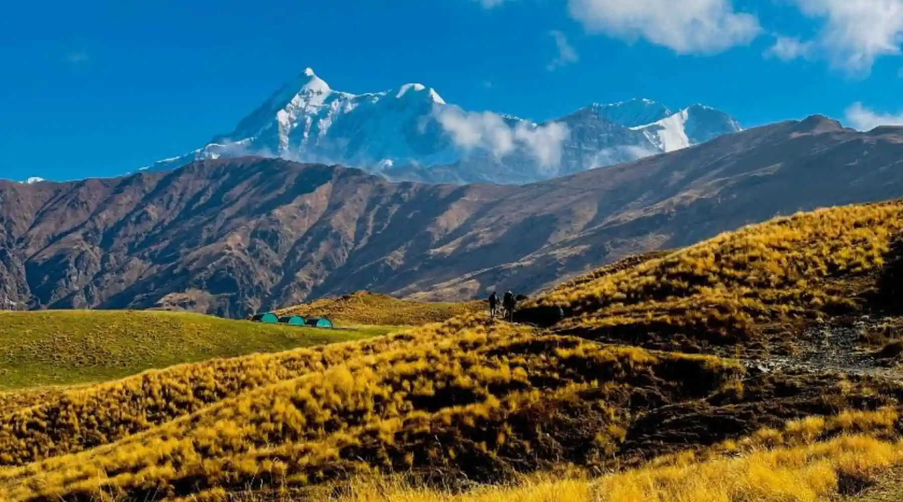
Imagine waking up inside a vast, rolling carpet of green — ringed on every horizon by the white teeth of the Himalaya, with Trishul's triple summit catching the first gold of dawn. That is precisely what greets you on the Ali Bedni Bugyal trek, a journey through two of Uttarakhand's most celebrated high-altitude grasslands in the Chamoli district. Bedni Bugyal sits at approximately 3,354 m and Ali Bugyal crowns the trail at around 3,450 m — yet the terrain remains gentle enough for first-time trekkers, making this one of the most rewarding weekend escapes in the Indian Himalaya.
A Meadow Like No Other
Bugyals — the vast sub-alpine and alpine grasslands of Garhwal — are Uttarakhand's best-kept secret, and Ali and Bedni together form one of the grandest of the lot. The payoff is immediate: within a day's walk from Wan village, you step out of oak-and-rhododendron forest into an ocean of grass that seems to roll directly into the sky.
Panoramic peaks: The trail frames Trishul (7,120 m), Nanda Ghunti (6,309 m), and the famous Roopkund ridge in a single sweeping view. On clear October mornings the visibility stretches to Mrigthuni and Hathi-Ghoda peaks.
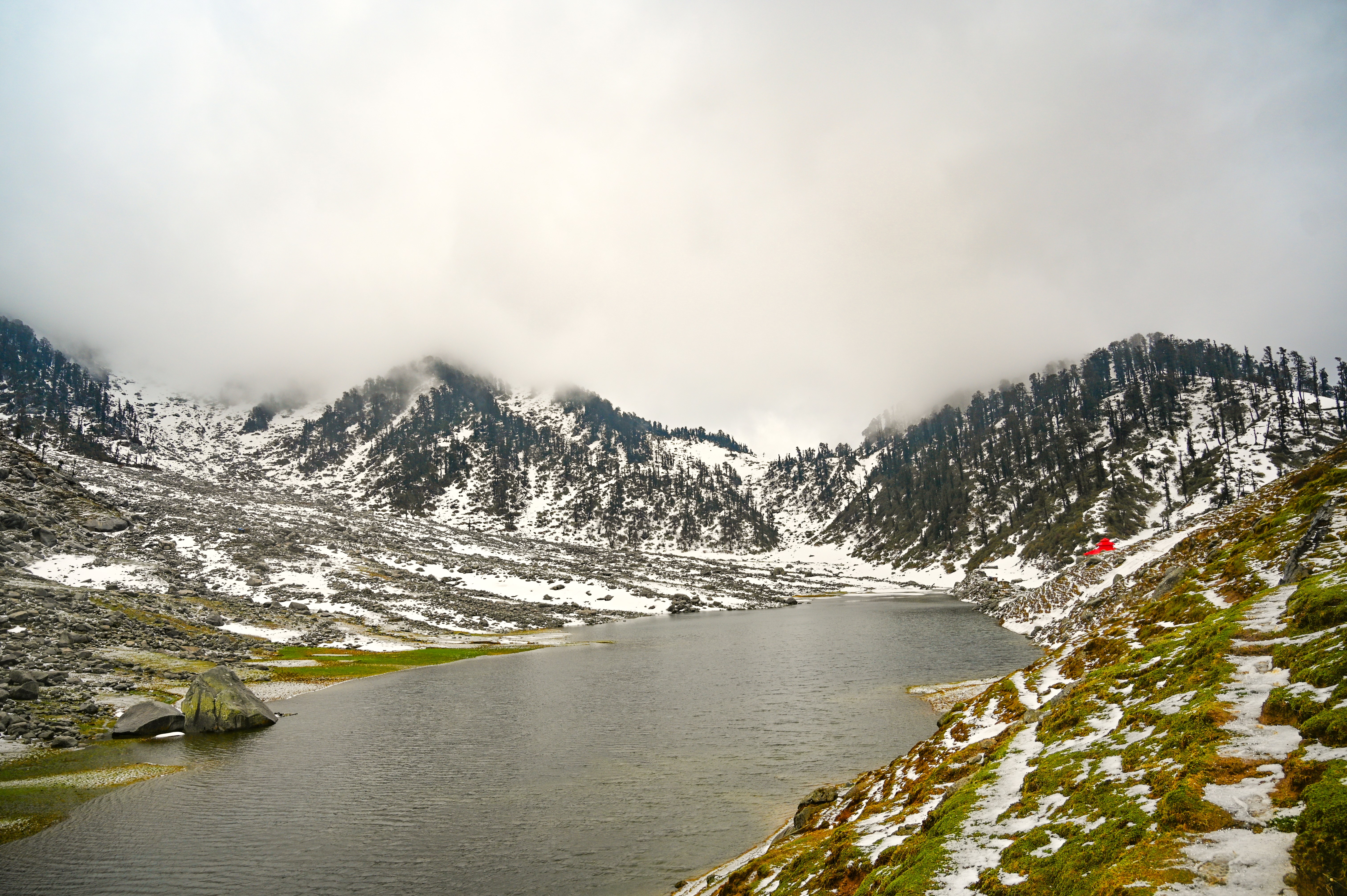
Bedni Kund: A small glacial lake nestled inside Bedni Bugyal, Bedni Kund is considered sacred by Hindu pilgrims on the Nanda Raj Jat Yatra — a religious procession held every twelve years. The lake's still waters mirror the surrounding peaks and add a spiritual depth rarely found on beginner-friendly treks.
Accessibility: Unlike the Roopkund trek, which demands multi-day high-altitude camping above 4,700 m, Ali Bedni Bugyal is a self-contained 3-night adventure with a maximum altitude of ~3,450 m. The base village of Wan is well-connected by road from Lohajung and Karanprayag.
Comparison with other bugyals: Dayara Bugyal in the Uttarkashi district offers comparable grassland beauty but a different mountain backdrop. Har ki Dun rewards with a glacial valley but is longer and more demanding. Ali Bedni Bugyal strikes the ideal balance — scenic intensity, spiritual character, and beginner suitability all in one package. See our full alpine meadow treks in India comparison for more options.
At a glance
The route at a glance
Trailhead: Wan Village (~2,400 m), Chamoli District, Uttarakhand
High point: Ali Bugyal (~3,450 m)
One-way distance: ~11 km
Round-trip distance: ~22 km
Total elevation gain: ~1,050 m
Key Waypoints
| Waypoint | Altitude (approx.) | Distance from previous point |
|---|---|---|
| Wan Village | 2,400 m | — |
| Ghairoli Patal | ~2,900 m | ~4 km |
| Bedni Bugyal (Bedni Kund) | ~3,354 m | ~4 km |
| Ali Bugyal | ~3,450 m | ~3 km |
The trail begins at the Wan check-post, where permits are verified. A well-worn path climbs steeply through mixed forest of oak and rhododendron — the rhododendrons blaze red in May. After roughly 4 km the gradient eases and you emerge at Ghairoli Patal, a small clearing used as a rest point and water source. The final push to Bedni Bugyal opens onto the meadow proper, with Bedni Kund visible from a short distance. A further 3 km of gentle undulating grassland connects Bedni Bugyal to Ali Bugyal, the higher of the two meadows and the finest viewpoint on the route.
Importantly, this trail is the lower section of the famous Roopkund trek complete trail, which continues north from Ali Bugyal to Pathar Nachauni, Bhagwabasa, and finally the skeleton lake at ~5,029 m. Trekking only as far as Ali Bugyal allows you to enjoy the best scenery while keeping the challenge within beginner reach.
Network coverage: Most telecom carriers lose signal above Ghairoli Patal. BSNL has marginally better coverage but is unreliable. Plan accordingly.
What each day actually looks like
Day 0 — Drive to Wan Village
From Rishikesh or Haridwar → Wan (~2,400 m)
Distance: ~230 km by road | Driving time: 8–10 hours
Depart Rishikesh early morning (5–6 AM) to ensure arrival in Wan before dark. The route follows National Highway 7 to Karanprayag, then turns toward Tharali and onward to Lohajung, from where a short motorable road descends to Wan. Shared jeeps and private taxis ply this route; no direct bus reaches Wan, but buses to Tharali or Lohajung are available. Overnight stay in Wan (homestay or basic guesthouse; budget ₹400–800 per room). Jolly Grant Airport near Dehradun is the nearest air hub — approximately 270 km from Wan.
Day 1 — Wan to Bedni Bugyal
Altitude gain: 2,400 m → ~3,354 m | Distance: ~8 km | Time: 5–6 hours
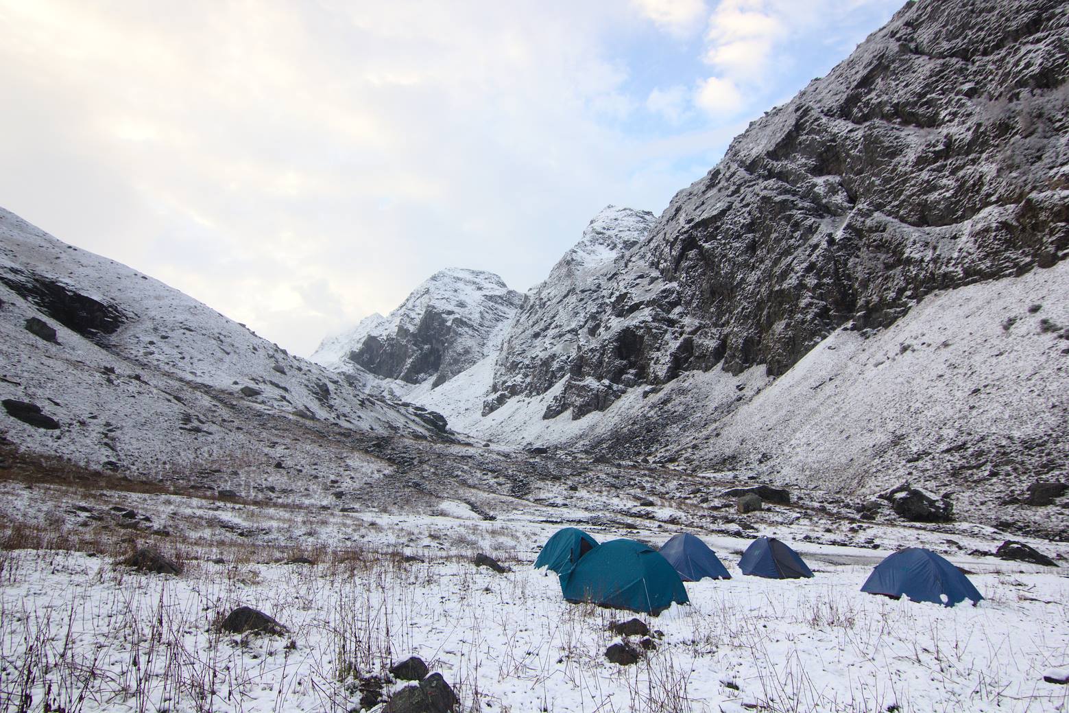
Start early (7 AM) to avoid afternoon cloud build-up. Register at the Wan check-post and collect/verify permits. The trail climbs steadily through forest, with short steep sections before Ghairoli Patal (~4 km, 2–3 hours). Take a 20-minute break here — this is the last reliable water source before the meadow. The final 4 km winds out of tree cover and onto open grassland. Arrive at the Bedni Bugyal campsite near Bedni Kund by early afternoon. Set up camp (bring your own tent or rent locally). Evening: explore the kund, attempt a short ridge walk for sunset views of Trishul. Meals: packed lunch from Wan; dinner at camp.
Day 2 — Explore Ali Bugyal, Bedni Kund, and Acclimatise
Distance covered: ~6 km (round trip to Ali Bugyal) | Rest/exploration day
This is the heart of the trek. Leave camp by 7:30 AM and walk the 3 km to Ali Bugyal — the higher meadow commands an extraordinary 270-degree Himalayan panorama. Spend 1–2 hours at Ali Bugyal before returning. Afternoon: circumambulate Bedni Kund, photograph wildflowers (May–June season), or simply rest and acclimatise. Evening star-gazing from the meadow is outstanding — no light pollution at this altitude. Meals: breakfast and dinner at camp; pack a lunch for the Ali Bugyal walk.
Day 3 — Bedni Bugyal to Wan
Altitude loss: ~3,354 m → 2,400 m | Distance: ~8 km | Time: 4–5 hours
Break camp after breakfast and descend to Wan. The descent is easier on lungs but harder on knees — trekking poles strongly recommended. Arrive Wan by early afternoon. Overnight stay in Wan homestay. Meals: breakfast at camp; lunch en route; dinner in Wan.
Day 4 — Drive Back to Rishikesh/Haridwar
Distance: ~230 km | Time: 8–10 hours
Depart Wan by 7 AM for the long return drive. You can break journey at Karanprayag or Rudraprayag for lunch. Reach Rishikesh by evening. See our guide on how to reach Rishikesh for onward travel options.
When to go
May–June ✅ Excellent
Snow from winter begins melting, revealing carpets of wildflowers — primulas, brahmakamal (in higher areas), and alpine asters. Views are generally clear in the mornings. Expect some lingering snow patches on the trail above Bedni Bugyal in early May. Temperatures at camp range from 2°C to 15°C. Highly recommended.
July–August ⚠️ Avoid
The southwest monsoon brings heavy rainfall to Chamoli. Leeches appear on the forest trail below Ghairoli Patal. Landslide risk on the approach road from Karanprayag increases significantly. The meadow itself becomes muddy and visibility is often poor. Most experienced operators suspend operations during this window.
September–October ✅ Best
Post-monsoon clarity delivers the sharpest mountain views of the year. The grass turns golden-amber, creating a photogenic contrast with the white peaks. Nights are cold (−2°C to 5°C at camp) but days are crisp and sunny. October is the single best month — stable weather, zero leeches, and spectacular light. Book early as demand peaks during this window.
November–April ❌ Closed/Dangerous
Heavy snowfall buries the trail and makes navigation hazardous for non-technical trekkers. The approach road can be blocked by snow beyond Lohajung. The route is effectively closed for most recreational trekkers during this period.
Is this trek right for you?
Overall rating: Easy–Moderate
The Ali Bedni Bugyal trek is widely regarded as one of the most beginner-friendly high-altitude treks in Uttarakhand. The maximum altitude of approximately 3,450 m keeps Acute Mountain Sickness (AMS) risk low compared to treks like Roopkund (5,029 m) or Kedarkantha (3,810 m in winter snow). That said, the cumulative elevation gain of ~1,050 m over 8 km still demands reasonable fitness.
Recommended pre-trek preparation:
- 3–4 weeks of daily 30-minute brisk walking or jogging
- Stair climbing (3–5 floors) to simulate ascent
- No prior trekking experience is strictly required
Age suitability: 10–60 years. Children under 10 should be assessed individually. Senior trekkers above 55 should consult a physician.
Medical caution: Not recommended for anyone with uncontrolled cardiac or respiratory conditions without explicit medical clearance. If you have a history of altitude sickness, consult a doctor and carry Diamox (acetazolamide) as per medical advice.
This is an ideal Ali Bedni Bugyal trek for beginners — the trail is well-worn, the altitude is manageable, the duration is short, and emergency descent to lower elevation is always feasible within a few hours.
For a broader list of beginner-suitable routes, see best treks in Uttarakhand.
What permits you need
The Ali Bedni Bugyal trail passes through the buffer zone of the Nanda Devi Biosphere Reserve, a UNESCO World Heritage landscape, and is regulated by the Uttarakhand Forest Department.
Required permits:
1. Forest Entry Permit — mandatory for all trekkers entering the reserve buffer zone.
2. Camping Permit — may be issued separately or bundled with the entry permit depending on current rules at the DFO Chamoli office.
Permit fee: Approximately ₹150–200 per person per day. (These figures are estimated based on recent Forest Department schedules. Verify the 2026 rate directly at the DFO Chamoli office or at chamoli.nic.in before your trek.)
How to obtain:
- At the trailhead: Register and pay at the Wan Village check-post on Day 1 of your trek. Carry original government-issued photo ID (Aadhaar, passport, or voter card).
- In advance: Visit or contact the DFO Chamoli office in Gopeshwar. Some registered guided tour operators arrange permits as part of their package — confirm this before booking.
Important: Regulations under the Nanda Devi Biosphere Reserve are subject to periodic revision. Always verify the latest requirements at the forest office or via our comprehensive Uttarakhand trek permits guide before departure.
What this trek will cost you
DIY Trek Cost Breakdown (Per Person)
| Item | Estimated Cost (₹) |
|---|---|
| Transport: Rishikesh ↔ Wan (shared jeep/taxi) | 1,500 – 2,500 |
| Forest entry/camping permit (2–3 days) | 300 – 600 |
| Accommodation in Wan (2 nights homestay) | 800 – 1,600 |
| Food (Wan meals + packed lunches) | 1,000 – 1,500 |
| Tent rental at campsite (2 nights) | 600 – 1,000 |
| Local guide from Wan | 1,600 – 2,400 (₹800–1,200/day × 2 days) |
| Porter (optional) | 1,400 – 2,000 (₹700–1,000/day × 2 days) |
| Total DIY estimate | ₹5,000 – 8,000 |
Note: Porter hire is optional but recommended for first-timers carrying full camping gear.
Guided Package (All-Inclusive)
| Package type | Estimated Cost (₹ per person) |
|---|---|
| Budget group package (8–12 trekkers) | 6,500 – 9,000 |
| Standard package (4–8 trekkers) | 9,000 – 12,000 |
| Private/customised package | 12,000 – 18,000 |
Guided packages typically include: transport from Rishikesh or Haridwar, permits, tents, sleeping bags, all meals on trek, guide, and porter. Verify inclusions carefully before booking.
(All cost figures are estimates for 2026. Transport fares and package prices may vary with fuel costs and operator pricing. Confirm with operators and the forest department before finalising.)
What to pack
Clothing
- Base layer: Moisture-wicking thermal inner (top and bottom)
- Mid layer: Fleece jacket or down vest
- Outer layer: Waterproof, windproof shell jacket
- Rain poncho: Lightweight, essential May–June and September
- Trekking trousers: Quick-dry; avoid denim
- Warm gloves and a sun hat (UV exposure is high at altitude)
- Wool or synthetic buff/balaclava for cold mornings
- Spare socks (2–3 pairs, merino wool preferred)
Footwear
- Ankle-support trekking shoes with Vibram or equivalent sole — waterproofed if possible
- Camp sandals or flip-flops for the evenings
- Gaiters: Optional but useful in May when snow patches remain
Gear
- Trekking poles (collapsible, 2 recommended for descents)
- Headlamp with spare batteries
- Sleeping bag rated to −5°C (essential; nights at Bedni Bugyal can drop close to freezing even in October)
- Daypack 30–40 L
- Dry bags or heavy-duty plastic bags to waterproof contents
Essentials
- Water bottles (1 L × 2) or hydration bladder; water purification tablets/filter
- Sunscreen SPF 50+ and UV-protective sunglasses
- Lip balm (wind and cold desiccate lips quickly at altitude)
- First-aid kit: bandages, antiseptic, blister pads, paracetamol, antacid, ORS sachets
- High-energy snacks: trail mix, energy bars, dark chocolate
- Trekking map or offline GPS app (no cell signal above Ghairoli Patal)
Documents
- Original government-issued photo ID
- Copies of permits
- Emergency contact card (laminated)
- Travel insurance document
For a more detailed checklist applicable to all Himalayan treks, see our trekking packing list India guide.
Recommended gear for this trek
Staying safe on the mountain
Altitude & AMS
At 3,450 m, the risk of Acute Mountain Sickness is relatively low, but not zero. Symptoms include persistent headache, nausea, loss of appetite, and fatigue. If symptoms appear, do not ascend further — descend immediately if they worsen. Hydrate well (3–4 litres per day), avoid alcohol on the first night at altitude, and ascend gradually. The Day 2 acclimatisation day in the itinerary exists for this reason.
Weather
Afternoon thunderstorms are common between June and September. Always start your walking day before 8 AM to reach camp before storm clouds build (typically 1–3 PM). If caught in a thunderstorm on open meadow, descend below the treeline and avoid standing under isolated trees or near water bodies.
Stream Crossings
Several small seasonal streams cross the trail, especially in May–June snowmelt season. Use trekking poles for balance; do not attempt crossings if water levels look unusually high after heavy rain.
Wildlife
No dangerous large predators are commonly encountered on this trail. Mule trains carrying supplies are frequent — step aside on the uphill side of the trail and let them pass. Keep food sealed in camp to avoid attracting scavenging animals.
Communication & Emergency
- No reliable mobile network above Ghairoli Patal on most carriers (Airtel, Jio, Vi). BSNL may work intermittently at Bedni Bugyal.
- Inform a responsible person of your full itinerary, expected return date, and emergency contact before leaving Wan.
- District Hospital Tharali: 01363-240200 (Verify this number is current in 2026 — provided as best available information.)
- SDRF Chamoli: Contact through local police or Chamoli District Emergency Control Room.
- Nearest major hospital: Government Medical College, Srinagar (Garhwal) — approximately 3–4 hours from Wan by road.
Responsible Trekking
The Ali Bedni Bugyal lies within the Nanda Devi Biosphere buffer zone. Carry all waste out — no littering. Use designated campsites only. Avoid picking wildflowers, especially brahmakamal, which is a protected species under Uttarakhand law.
Similar treks to explore
Kareri Lake Trek: Complete Guide for 2026
Plan your Kareri Lake trek with our 2026 guide covering route, difficulty, permits, cost, packing list, best time to visit, and day-wise itinerary.
Buran Ghati Trek: Complete Guide 2026
The Buran Ghati Trek is a difficult 40 km trail in Himachal Pradesh crossing a 4,700 m pass with India's only glacier rappel descent on a mainstream trek.
Indrahar Pass Trek: Routes, Difficulty & Best Time
Indrahar Pass trek is a moderate-to-difficult 4-day route in the Dhauladhar range, starting from McLeod Ganj and reaching 4,342 m (14,245 ft). Best done September–October.
Common questions answered
Yes — the Ali Bedni Bugyal trek is rated Easy–Moderate and is one of the best Himalayan introductory treks available. The maximum altitude of approximately 3,450 m means AMS risk is low, the trail is well-marked, and the total trekking duration is only 2 days (up and down). No prior trekking experience is strictly required, but 3–4 weeks of daily cardio preparation — brisk walking, jogging, or stair climbing — will make the experience far more enjoyable.