Why Kolahoi Glacier Trek is on every trekker's list
In a region increasingly crowded by Instagram-famous trails, the Kolahoi Glacier Trek remains refreshingly uncrowded. While routes like the Kashmir Great Lakes Trek draw heavy footfall each season, Kolahoi sees a fraction of those numbers — making it ideal for trekkers who value solitude over spectacle.
What sets this trek apart:
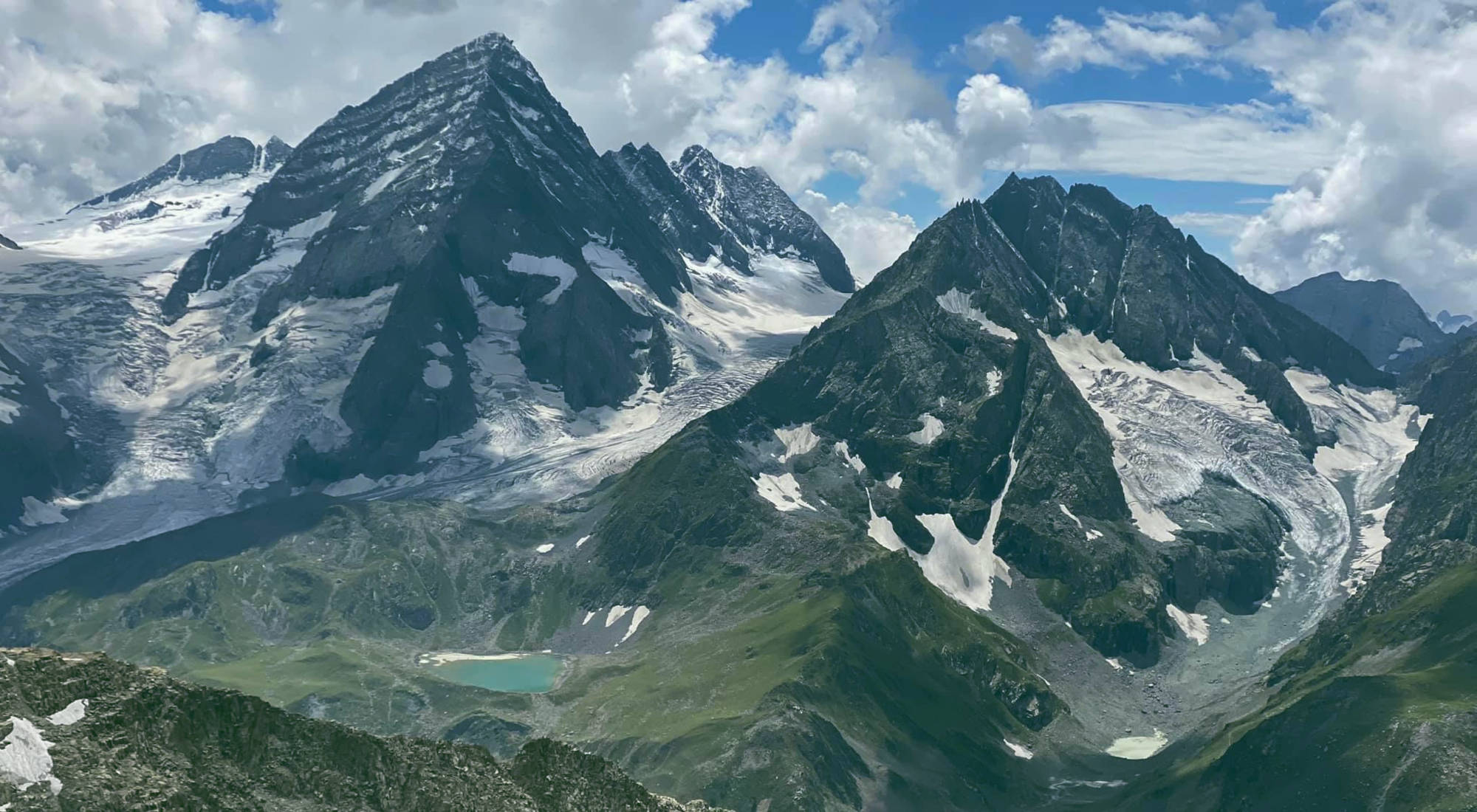
- Kolahoi Peak views: Standing at 5,425 m, Kolahoi (also called the "Lightening Peak") is the highest summit in the Kashmir Valley and a serious mountaineering objective. From the base camp, the views of its jagged ridgeline and hanging glaciers are extraordinary.
- Source of the Lidder River: The Kolahoi Glacier is the primary feeder of the Lidder River, which flows through Pahalgam and sustains the entire valley. Reaching the glacier's snout feels like finding the origin of a lifeline.
- Remote alpine meadows: The trail passes through Lidderwat and Sekiwas — open, flower-carpeted meadows that are far less visited than Baisaran Valley or the meadows immediately around Pahalgam.
- Cultural richness: The route passes seasonal encampments of the Gujjar and Bakarwal communities, Kashmir's semi-nomadic herding groups, who migrate with their livestock to these high pastures each summer. Interactions with them offer a rare glimpse into a centuries-old transhumance lifestyle.
- Proximity to Pahalgam: The trek starts from one of Kashmir's most accessible hill stations, making logistics simple. Pahalgam is just ~96 km from Srinagar (see our Pahalgam Travel Guide).
For anyone serious about Kashmir glacier trekking, Kolahoi delivers a complete experience: technical enough to be rewarding, accessible enough not to require mountaineering credentials.
At a glance
Ask TrekSage about Kolahoi Glacier Trek
Get instant answers grounded in verified trek data — beginner-friendliness, best months, permits, packing, and more.
The route at a glance
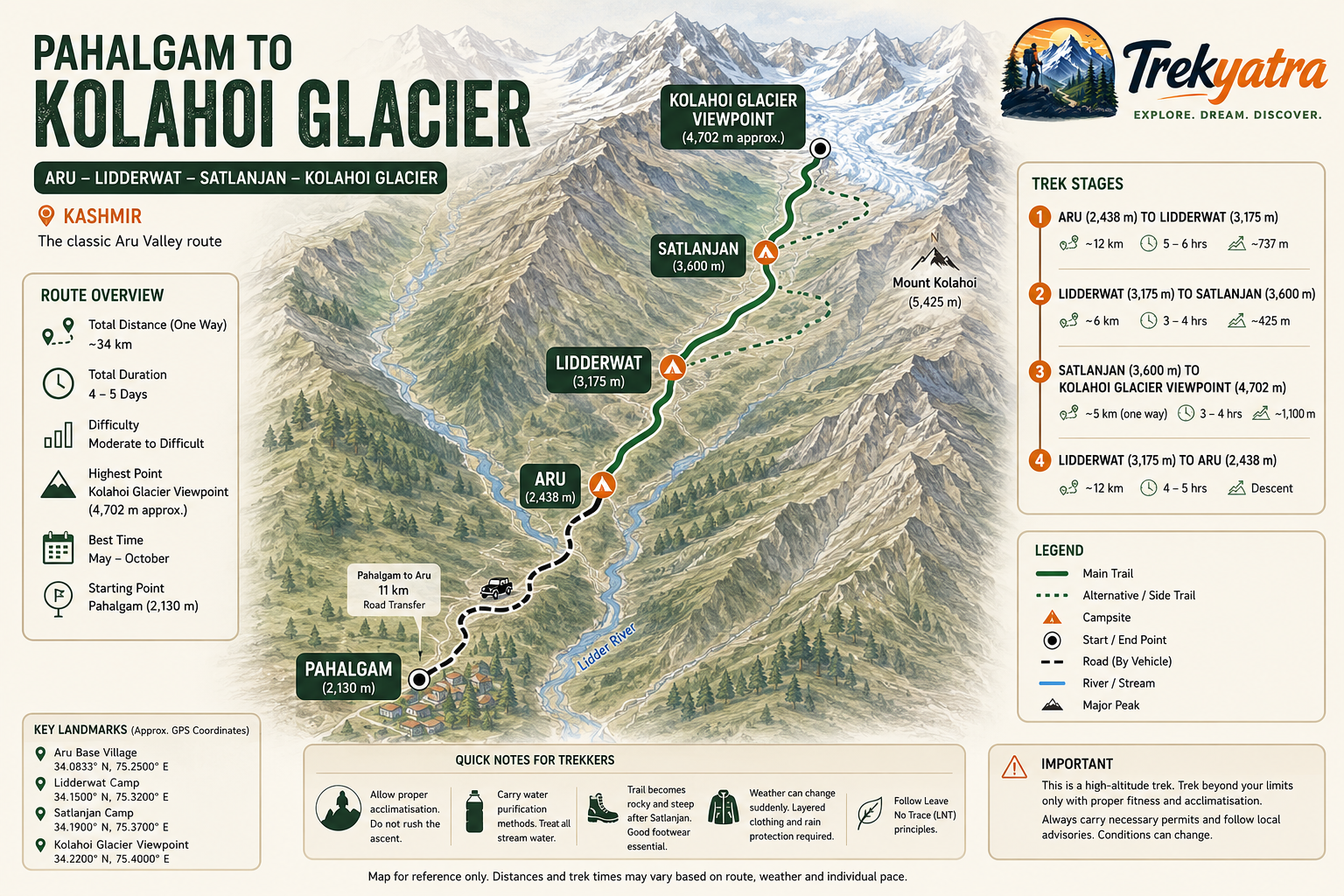
The standard Aru Valley to Kolahoi Glacier trek follows the Lidder River valley upstream, gaining elevation gradually before the final push to the glacier. The full round-trip distance is approximately 40–45 km, depending on the exact campsite positions and any exploration at the glacier.
Trail Sequence: Pahalgam → Aru Valley → Lidderwat → Sekiwas → Kolahoi Glacier Base Camp
📍 Map Note: We recommend embedding a route map graphic or interactive map widget here showing the trail from Aru Village to Kolahoi Base Camp with campsite markers. A Kolahoi Glacier Trek route map significantly aids first-time trekkers in visualising the terrain.
Key landmarks along the route:
- Pahalgam town — base logistics hub, last reliable ATM and pharmacy
- Aru Village — trailhead, last settlement with guesthouses
- Lidderwat meadow — first major camping ground, wide open pasture beside the Lidder
- Sekiwas — high-altitude meadow, final camping before glacier
- Kolahoi Glacier Base Camp — end point of the standard trek, with views of the glacier and Kolahoi Peak
- Great Himalayan National Park buffer zone — portions of the route pass through or adjacent to this protected area
The elevation profile rises steadily rather than sharply, with the steepest section occurring between Sekiwas and the base camp on the moraine terrain.
Elevation Profile at a Glance
| Campsite / Location | Approximate Altitude | Cumulative Distance from Pahalgam |
|---|---|---|
| Pahalgam | 2,130 m | 0 km |
| Aru Village | 2,400 m | ~11 km (by road/trail) |
| Lidderwat | 3,050 m | ~22 km |
| Sekiwas | 3,600 m | ~30 km |
| Kolahoi Base Camp | 4,100 m | ~37–40 km |
Maximum altitude: ~4,100 m at base camp (Kolahoi Peak summit at 5,425 m is a mountaineering objective, not part of the standard trek)
Total ascent: approximately 1,970 m from Pahalgam to base camp
What each day actually looks like
The following Kolahoi Glacier Trek itinerary is designed for trekkers arriving in Srinagar and spending 6 days on the route. A 5-day fast-paced version is possible for experienced trekkers by combining Day 1 and Day 2.
Day 1: Arrive Srinagar / Drive to Pahalgam — Acclimatise
- Altitude: 1,585 m (Srinagar) → 2,130 m (Pahalgam)
- Drive: ~96 km, approximately 2.5–3 hours
- Highlights: Settle into Pahalgam, explore the Lidder River banks, stock up on supplies and snacks, confirm permits at the Forest Department office
- Overnight: Hotel or guesthouse in Pahalgam
Use this day to acclimatise and avoid any strenuous activity. Sort gear, confirm porter/guide bookings, and rest.
Day 2: Pahalgam to Aru Valley
- Distance: ~11 km (partly by road, partly trail) or direct drive to Aru (~12 km by road)
- Altitude gain: 2,130 m → 2,400 m
- Duration: 3–4 hours trekking or 30 minutes by vehicle + short hike
- Highlights: Aru village, Aru Valley meadows, views of surrounding ridgelines, Lidder River crossing on wooden bridges
- Overnight: Guesthouse or campsite at Aru
Most organised groups take a shared jeep from Pahalgam to Aru to save time and energy. Check our How to Reach Pahalgam guide for transport details.
Day 3: Aru to Lidderwat
- Distance: ~10–11 km
- Altitude gain: 2,400 m → 3,050 m
- Duration: 5–6 hours
- Highlights: Dense conifer forest, Lidder River crossings, gradual meadow opening into Lidderwat, Gujjar herder encampments, first views of snow peaks
- Overnight: Campsite at Lidderwat
This is a moderate day with sustained uphill stretches. The forest canopy provides shade in the morning, but the final push to Lidderwat is exposed.
Day 4: Lidderwat to Sekiwas
- Distance: ~8–9 km
- Altitude gain: 3,050 m → 3,600 m
- Duration: 4–5 hours
- Highlights: Open alpine meadows, wildflower carpets (June–August), Bakarwal camps, dramatic views of rock faces above, Sekiwas meadow arrival
- Overnight: Campsite at Sekiwas
Rest at Sekiwas in the afternoon. Do not push further on Day 4 — altitude acclimatisation here is critical before the glacier push.
Day 5: Sekiwas to Kolahoi Glacier Base Camp and Return to Lidderwat
- Distance: ~14–16 km round trip from Sekiwas
- Altitude gain: 3,600 m → 4,100 m (and descent)
- Duration: 7–9 hours total
- Highlights: Moraine terrain, lateral glacier views, Kolahoi Peak (5,425 m) close-up, glacier snout, Lidder River origin point, return to Lidderwat by evening
- Overnight: Campsite at Lidderwat
This is the most demanding day. Start early (by 6 AM) to avoid afternoon weather changes and the risk of afternoon storms common in August. Glacier moraine is loose and slow-going.
Day 6: Lidderwat to Aru / Pahalgam
- Distance: ~21–22 km
- Altitude loss: 3,050 m → 2,130 m
- Duration: 6–7 hours trekking (or trek to Aru and jeep to Pahalgam)
- Highlights: Retracing the Lidder Valley, forest walk, arrival in Pahalgam, celebration dinner
- Overnight: Hotel in Pahalgam or onward travel to Srinagar
Campsite Details
For more on Kolahoi Glacier Trek camping logistics, here's a breakdown of each campsite:
Aru Village (2,400 m)
- Surface: Flat grassy meadow and designated camping ground
- Water: Lidder River tributary; boil or filter before drinking
- Facilities: Basic guesthouses available, toilet blocks in village, some tea shops
- Type: Fixed camps available through operators; independent camping permitted
Lidderwat (3,050 m)
- Surface: Open meadow, slightly uneven in places
- Water: Lidder River — clean but treat before drinking
- Facilities: No permanent structures; porter camps set up toilet tents; no guesthouses
- Type: Wild camping / operator tent camps; no fixed infrastructure
Sekiwas (3,600 m)
- Surface: Rocky meadow, less flat than Lidderwat — require careful tent placement
- Water: Seasonal stream from snowmelt; may be reduced in October
- Facilities: Wilderness camping only; no facilities
- Type: Wild camping; operators bring all equipment
When to go
Choosing the right window is critical, as Kolahoi Glacier Trek weather varies dramatically by season.
June – July
- Conditions: Higher sections may still have residual snow, especially approaching Sekiwas and the base camp. Lush meadows are at their most vivid green, with wildflowers in bloom.
- Temperatures: Daytime 12–18°C at Lidderwat; nights drop to 2–5°C. At Sekiwas, nights can approach 0°C.
- Suitability: Good for trekkers comfortable with snow underfoot on upper sections. Stunning photography. Rivers are higher due to snowmelt — some crossings need extra care.
August – September (Peak Season)
- Conditions: Best overall weather window. Skies are clearest, trails are fully snow-free, glacier is accessible. This is the most popular period.
- Temperatures: Daytime 15–20°C at lower camps; nights 3–8°C at Lidderwat, 0 to -3°C at Sekiwas.
- Suitability: Recommended for all experience levels meeting fitness requirements. Expect afternoon thunderstorms in August — start summit days early.
October
- Conditions: Cold nights, risk of early snowfall above 3,500 m. Fewer trekkers on trail — genuine solitude possible. Landscape transitions to autumn gold.
- Temperatures: Daytime 8–12°C at lower camps; nights can drop to -5°C or below at Sekiwas.
- Suitability: Experienced trekkers with cold-weather gear only. Check current snow reports before committing.
November – May: AVOID
- Heavy snowfall renders the route impassable. The trail is effectively closed. Forest Department may restrict access. Do not attempt.
Is this trek right for you?
Difficulty rating: Moderate-to-Challenging
The Kolahoi Glacier Trek difficulty sits in a middle band — it is not a technical mountaineering route, but it demands genuine physical preparation and prior trekking experience.
What makes it challenging:
- Cumulative elevation gain of ~1,970 m over 3 days of ascent
- River crossings on slippery rocks (especially in June–July when meltwater is high)
- Glacier moraine terrain on Day 5 — loose, unstable, energy-sapping
- Altitude exposure above 3,500 m, where AMS (Acute Mountain Sickness) risk increases meaningfully
- Long Day 5 (up to 9 hours of walking)
Who can do it:
- Trekkers with prior experience of at least 2–3 multi-day hikes at altitude are strongly recommended
- Those who have completed shorter Kashmir treks (like Tarsar Marsar — see our Tarsar Marsar Trek Guide) are well-positioned
- Physically fit first-timers with a local guide can attempt it but should not underestimate the trail
Training recommendations (start 6–8 weeks before):
- Cardiovascular base: 30–45 minutes of aerobic exercise (running, cycling, swimming) 4–5 days a week
- Leg strength: Squats, lunges, step-ups with a loaded pack
- Loaded backpack walks: Weekend hikes with a 10–12 kg pack on hilly terrain
- Read our Altitude Sickness Prevention Guide before departure
Altitude sickness note: AMS symptoms (headache, nausea, dizziness, fatigue) can appear above 3,500 m. Acclimatise at Sekiwas before the glacier push. If symptoms worsen, descend immediately — do not push on.
What permits you need
Sorting permits before you reach the trailhead is non-negotiable. Here is what the Kolahoi Glacier Trek permits situation looks like for the 2026 season:
Indian Nationals:
- No Inner Line Permit (ILP) required for this zone as of 2026
- A J&K Forest Department entry permit / nature permit is required for trekking into the protected buffer zones along this route
- Approximate fee: INR 50–100 per person per day
- Where to obtain: Pahalgam Forest Department office (located near the main market in Pahalgam town). Bring original government-issued ID (Aadhaar, passport, voter card).
- Organised tour operators typically handle permit procurement for their clients.
Foreign Nationals:
- This area of South Kashmir may carry additional access restrictions for foreign nationals. As of early 2026, the situation remained subject to change based on J&K government advisories.
- Carry a valid passport and relevant visa documents at all times on trail.
For a comprehensive overview of trekking permit requirements across Kashmir, see our Kashmir Trekking Permits Guide.
What this trek will cost you
Here is an honest breakdown of what the trek costs in the 2026 season.
DIY / Independent Budget (per person):
| Item | Estimated Cost (INR) |
|---|---|
| Srinagar → Pahalgam shared taxi/bus | 500–800 |
| Pahalgam → Aru Village shared jeep | 150–300 |
| Forest permit fees (~5–6 days) | 300–600 |
| Guide / local shepherd guide (per day) | 800–1,200 |
| Porter (per day, if required) | 700–1,000 |
| Tent rental (if not carrying own) | 300–500 per night |
| Food / ration on trail (per day) | 400–600 |
| Pahalgam accommodation (1–2 nights) | 800–2,000 per night |
| Estimated DIY Total (6 days) | ~INR 10,000–18,000 |
All DIY cost estimates are approximate and subject to seasonal variation. Porter and guide rates are typically higher in peak August–September season.
Organised Package (per person):
- A 6-day fully organised Kolahoi Glacier Trek package from a registered Pahalgam operator typically costs INR 8,000–15,000 per person, including guide, porter, all meals on trail, camping gear, and permit assistance.
- Group size affects per-person cost — smaller groups (2–4 people) will pay closer to the upper range.
- Budget operators may offer lower rates; always verify what is included before paying.
For context on how Kolahoi costs compare to other Kashmir routes, see our Best Treks in Kashmir comparison guide.
What to pack
A practical Kolahoi Glacier Trek packing list — marked with ✅ (essential) or ⚪ (optional but recommended).
Clothing:
- ✅ Moisture-wicking base layer (top and bottom) — synthetic or merino wool
- ✅ Mid-layer fleece or down jacket
- ✅ Waterproof and windproof outer jacket (hardshell)
- ✅ Waterproof trekking trousers or convertible pants
- ✅ Warm hat / beanie
- ✅ Sun hat or cap
- ✅ Trekking gloves (lightweight; add liner gloves for October)
- ✅ Thermal/wool socks × 3–4 pairs
- ⚪ Neck gaiter / buff
Footwear:
- ✅ Waterproof, ankle-support trekking boots (broken in before the trek)
- ✅ Camp sandals or lightweight shoes for evenings
- ⚪ Gaiters (highly recommended for June–July snow sections and moraine)
Gear:
- ✅ Trekking poles (pair)
- ✅ Headlamp + spare batteries
- ✅ Sleeping bag rated to -10°C (critical for Sekiwas nights)
- ✅ Sleeping mat / pad (if not provided by operator)
- ✅ Backpack 50–60L with rain cover
- ✅ Dry bags / waterproof stuff sacks for electronics and spare clothing
- ⚪ Trekking umbrella
Safety & Health:
- ✅ Personal first-aid kit (blister care, bandages, antiseptic, pain relief)
- ✅ AMS medication — Diamox (Acetazolamide) — consult your doctor before the trek
- ✅ Sunscreen SPF 50+ (UV intensity is high at altitude)
- ✅ Lip balm with SPF
- ✅ Water purification tablets or a filter
- ✅ ORS (Oral Rehydration Salts) sachets
- ⚪ Pulse oximeter (useful for monitoring oxygen saturation above 3,500 m)
Documents:
- ✅ Original government-issued ID (Aadhaar / Passport)
- ✅ Permit copies (keep digital and physical copies)
- ✅ Travel insurance documents (ensure policy covers high-altitude trekking up to 4,500 m)
- ✅ Emergency contact list including local guide, operator, and J&K Tourism helpline
Staying safe on the mountain
The Kolahoi Glacier Trek is a wilderness route with real hazards. Take these seriously.
Acute Mountain Sickness (AMS):
- AMS can affect anyone above 3,500 m regardless of fitness level
- Common symptoms: persistent headache, nausea, vomiting, dizziness, loss of appetite, disturbed sleep
- Rule: Never ascend with worsening AMS symptoms. Descend immediately.
- HACE (High-Altitude Cerebral Edema) and HAPE (High-Altitude Pulmonary Edema) are life-threatening and require emergency descent
- Read our dedicated Altitude Sickness Prevention Guide
Glacier and Moraine Safety:
- Do not venture onto the glacier surface without a guide and proper equipment — the Kolahoi Glacier has crevasses and unstable ice
- Stay on marked moraine trails approaching the base camp
- Avoid solo approach to the glacier snout
- Loose moraine rocks can shift underfoot — use trekking poles and move slowly
Kolahoi Glacier Trek Weather — Afternoon Storms:
- In August, afternoon thunderstorms are common above 3,000 m
- Always start summit/glacier days by 5:30–6:00 AM to be at base camp and returning by early afternoon
- If you see anvil-shaped clouds building, begin your descent immediately
- Kolahoi Glacier Trek weather can change within 30 minutes at altitude
River Crossings:
- Lidder River crossings are highest in June–July due to snowmelt
- Unbuckle your pack hip belt before crossing so you can shed your pack if you fall
- Use trekking poles for stability; cross at wide, shallow sections, never near waterfalls
Wildlife:
- Brown bears have been reported in the Aru Valley region and surrounding forests
- Make noise while walking through dense forest sections; do not trek at dawn or dusk alone
- Store food away from tent and never inside your sleeping area at camp
Hiring a Local Guide:
- A registered local guide is not just a navigation aid — they know weather patterns, safe crossing points, and emergency evacuation routes
- First-time visitors to this trail should always hire one
Emergency Contacts:
- J&K Tourism Helpline: 1800-180-7999 (verify this number is active before departure)
- Pahalgam Police Station: Contact number should be obtained locally upon arrival
- Your trek operator's 24-hour contact number
- Nearest hospital: District Hospital Anantnag (~45 km from Pahalgam)
Similar treks to explore

Mount Everest Trek Guide 2026: Everything You Need to Know
The Mount Everest trek to Base Camp (EBC) is a 130 km, 14–16 day trek reaching 5,364 m, best done in spring or autumn.
Snow Leopard Trek Hemis: The Ultimate 2026 Guide
The snow leopard trek in Hemis National Park, Ladakh, offers the world's best chance of spotting a wild snow leopard, with 70–80% guided sighting success rates
Padum to Darcha Trek: Complete High-Altitude Route Guide
The Padum to Darcha trek covers ~115–120 km in 8–9 days, crossing Shingo La (~5,060 m) between Zanskar and Lahaul.
Common questions answered
The Kolahoi Glacier Trek is rated moderate-to-challenging. It is suitable for trekkers with prior experience of multi-day hiking, particularly those comfortable with altitude above 3,500 m. The challenges include cumulative elevation gain of nearly 2,000 m, river crossings that require balance and care (especially in June–July), and the demanding moraine terrain on the approach to the glacier base camp. Complete beginners attempting it without a guide would be taking on unnecessary risk.
Kolahoi Glacier Trek — Latest News
Kolahoi Glacier hiking routes
New hiking route information released for Kolahoi Glacier Trek in Kashmir, helping trekkers plan safer, better-informed expeditions to this 4,892m alpine destin
J&K: CM Omar Abdullah Unveils 2025 Calendar and Trekking Maps
CM Omar Abdullah releases official 2025 trekking maps and calendar for Kashmir. Improved resources now available for Kolahoi Glacier Trek planning and navigatio
Live Conditions
Real-time weather & trail status
Trail Conditions
Crowdsourced reports from trekkers who've done this route
Sign in to add a trip report
Find a Trek Buddy
Connect with trekkers planning the same route
No buddies yet for this trek
Sign in and be the first to post a planning signal.