Why Lamayuru to Chilling Trek is on every trekker's list
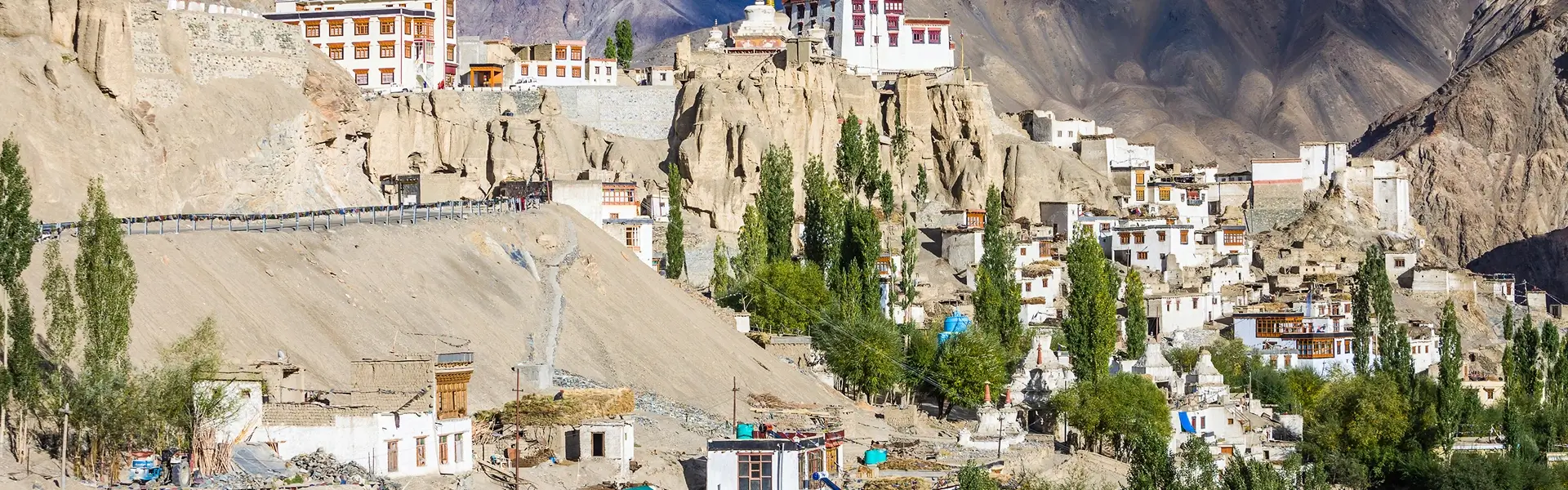
Few trails in the Indian Himalaya match the raw, untamed beauty of the Lamayuru to Chilling trek. Stretching approximately 75–80 km across the barren ridgelines and hidden gorges of Ladakh's Zanskar fringe, this six-to-seven-day journey connects two of the region's most evocative landmarks: the ancient cliff-top Lamayuru Monastery (3510m) and the riverside hamlet of Chilling (approximately 3100m) at the confluence of the Zanskar and Indus rivers.
While the Markha Valley trek has become a household name on the Ladakh circuit and the Chadar trek draws winter adventurers onto the frozen Zanskar River, the Lamayuru–Chilling route remains beautifully overlooked. You will cross three significant passes — Prinkiti La (3750m), Konzke La (4930m), and Dundunchen La (4650m) — traverse medieval villages that see fewer foreign trekkers in an entire season than Markha sees in a weekend, and wake each morning to silence broken only by wind and yak bells.
This is not a trail for first-timers. But for trekkers with solid high-altitude experience, it ranks among the finest wilderness routes in South Asia. Here is everything you need to plan it for the 2026 trekking season.
The honest answer is: choose this trek precisely because most people don't.
Ladakh's most-visited routes have become victims of their own fame. On a peak August weekend, Markha Valley campsites can feel crowded, and even the Stok Kangri base camp has a queue. The Lamayuru–Chilling corridor, by contrast, still operates at a pace that feels genuinely remote. Days can pass without encountering another trekking group, and the villagers of Sumdah Chenmo and Sumdah Chun welcome visitors with a warmth born from genuine rarity rather than tourist habit.
Beyond the solitude, the landscape itself is extraordinary. The trek begins in Lamayuru's famous moonland — a UNESCO-nominated lunar terrain of eroded mud pillars and cream-coloured sediment formations that looks like nothing else on Earth. From there, the trail weaves through the deeply incised gorges of the Yapola River tributaries before climbing to high pastures and the windswept saddle of Konzke La, where on a clear day the panorama encompasses peaks stretching toward the Karakoram.
Cultural immersion is another defining feature. The villages along this route — particularly Wanla, with its restored three-storey Sumtseg temple, and the twin Sumdah settlements — belong to Ladakh's pre-modern cultural fabric. Homestay hosts here still practice traditional agro-pastoral livelihoods, and the monasteries you encounter are working religious institutions, not museum pieces.
For trekkers who have already done Markha Valley or similar routes and are asking "what's next?", this is the answer.
At a glance
The route at a glance
The Lamayuru–Chilling route runs roughly south-east to south, cutting through the western arm of the Zanskar Range. It is best understood as three distinct terrain phases:
-
Moonland and gorge descent (Days 1–2): From Lamayuru, the trail drops through sculpted badlands toward the Yapola Valley and the village of Wanla, crossing the easy Prinkiti La (3750m). Elevation changes are moderate, and the trail is well-worn.
-
High-altitude heart (Days 3–4): The route climbs steadily through Hinju toward the crux of the trek — the long ascent to Konzke La (4930m). This is the most demanding section, with significant altitude gain and limited shelter. The descent leads into the hidden valley of Sumdah Chenmo.
-
Zanskar approach (Days 5–6): A gentler traverse through Sumdah Chun before a final pass — Dundunchen La (4650m) — delivers you into the Zanskar gorge system and down to Chilling.
Total distance: approximately 75–80 km
Maximum altitude: Konzke La, approximately 4930m
Net elevation change: descent overall (Lamayuru 3510m → Chilling ~3100m), but cumulative gain across passes is substantial
Map tip: Download offline maps via Gaia GPS or Maps.me before you leave Leh. Cellular signal is absent for the vast majority of this route. The Zanskar Valley travel guide has additional orientation context.
Key Passes and Villages Along the Route
| Waypoint | Approx. Altitude | Notes |
|---|---|---|
| Lamayuru | 3510m | Start point; monastery, basic guesthouses |
| Prinkiti La | 3750m | First pass; gentle ascent |
| Wanla | 3200m | Village with Wanla Gompa (Sumtseg temple) |
| Hinju | ~3500m | Small settlement; last reliable water before Konzke La |
| Hanupata La | ~4200m | Intermediate high point |
| Konzke La | 4930m | Highest point of trek; crux day |
| Sumdah Chenmo | ~3950m | Hidden valley village; homestays available |
| Sumdah Chun | ~3800m | Twin village; quieter |
| Dundunchen La | 4650m | Final major pass |
| Chilling | ~3100m | End point; Zanskar–Indus confluence nearby |
River crossings: The trail involves multiple crossings of Yapola River tributaries, particularly between Wanla and Hinju. Crossings are typically manageable in August–September but can be thigh-deep and swift during peak snowmelt in June–July. Use trekking poles and unbuckle your pack hipbelt before wading.
Leh to Lamayuru
- Distance: approximately 127 km on NH1 (National Highway 1, the Srinagar–Leh highway)
- Duration: 2.5–3 hours depending on road conditions and checkpost queues
- Options:
- Shared jeep/sumo: ₹800–1200 per seat from Leh's main bus stand area (shared with other passengers heading toward Kargil)
- Private taxi: ₹2500–3500 for the full vehicle
- Local bus: JKRTC buses run the Leh–Kargil route via Lamayuru, but schedules are limited and unreliable. Not recommended if you have a fixed trek start date.
- Early-season note: NH1 through the Fotu La and Namika La sections can be closed by rockfall or late snowfall in early June. Check with locals or your operator before booking non-refundable transport.
Chilling to Leh
- Distance: approximately 80 km via the Nimmu–Chilling road along the Zanskar River gorge
- Duration: approximately 2–2.5 hours
- Options: Private taxi (pre-arranged) ₹2000–3000. There is no reliable public transport from Chilling. Pre-arrange your pickup before you begin the trek — signal is available in Leh but not at Chilling.
- Road condition: The Nimmu–Chilling road runs through the Zanskar gorge and is a dramatic but occasionally fragile route — check for closure status if there have been recent heavy rains.
Leh Airport
Kushok Bakula Rimpochee Airport (IXL) is connected to Delhi (multiple daily flights, ~1.5 hours), Mumbai, and several other Indian cities. Book flights well in advance for the July–September peak season. Weather diversions to Jammu or Chandigarh are common — build a buffer day before your trek start.
What each day actually looks like
Day 0: Arrive Leh — Acclimatisation Begins
Altitude: 3524m | Activity: Arrival and rest
Fly into Leh's Kushok Bakula Rimpochee Airport. Do very little. Hydrate constantly, avoid alcohol, and sleep as much as your body allows. Even fit, experienced trekkers are vulnerable to acute mountain sickness (AMS) in the first 24–48 hours at this altitude.
Day 1: Leh to Lamayuru — Drive and Explore
Drive: ~127 km, 2.5–3 hours on NH1 | Camp altitude: 3510m
After a second acclimatisation morning in Leh (see section below), take a shared jeep or private taxi to Lamayuru village. Arrive by early afternoon, leaving time to explore Lamayuru Monastery — one of the oldest and most atmospheric in Ladakh, perched dramatically above the moonland valley. Camp near the monastery or stay in a basic guesthouse. Organise your horseman and guide if not pre-arranged.
Day 2: Lamayuru to Wanla — Cross Prinkiti La
Distance: ~14 km | Altitude gain/loss: +240m / -550m | Camp altitude: ~3200m
The first trekking day is a manageable warm-up. The trail climbs gently through the moonland to Prinkiti La (3750m) — an easy pass offering your first panoramic views — then descends via a well-defined path to Wanla village. Explore the extraordinary Wanla Gompa, a three-storey temple complex. Camp near the village. A local family may offer meals.
Day 3: Wanla to Hinju
Distance: ~12 km | Altitude gain/loss: +300m / -100m | Camp altitude: ~3500m
A moderate day following the Yapola drainage upward. The trail narrows through gorge sections and involves one or two river crossings. Hinju is a tiny settlement — do not expect shops. Fill all water containers here; the section toward Konzke La is dry. Camp on flat ground near the village.
Day 4: Hinju to Sumdah Chenmo via Konzke La — The Crux Day
Distance: ~14 km | Altitude gain/loss: +1430m / -980m | Camp altitude: ~3950m
The hardest day of the trek by a significant margin. Start before 6am to avoid afternoon instability on the pass. The ascent to Konzke La (4930m) is long and relentless, gaining over 1400m from camp. Take it slow, breathe deliberately, and watch all group members for AMS symptoms. The views from the pass are extraordinary — a full panorama of the Zanskar and Ladakh ranges.
The descent to Sumdah Chenmo is steep on loose scree initially, then gentles into a beautiful hidden valley. Homestays are available here and are warmly recommended — a hot meal and a real bed after the hardest day is well earned.
Day 5: Sumdah Chenmo to Sumdah Chun
Distance: ~8 km | Altitude gain/loss: ~+100m / -150m | Camp altitude: ~3800m
A short, restorative day. The trail between the twin Sumdah villages is relatively flat, following the valley floor. Use this day to rest legs and re-examine gear for the final pass. The two villages are culturally fascinating — ask your guide about the local irrigation systems (kuls) and traditional barley cultivation.
Day 6: Sumdah Chun to Chilling via Dundunchen La
Distance: ~17 km | Altitude gain/loss: +850m / -1550m | Camp altitude: 3100m (end point)
The final big day. The ascent to Dundunchen La (4650m) is demanding but feels psychologically easier knowing the end is near. From the pass, the descent into the Zanskar gorge is dramatic — the canyon walls narrow and the trail becomes more technical before opening into the riverside village of Chilling. Your pre-arranged taxi should meet you here.
Day 7 (Option): Chilling to Leh by Road
Drive: ~80 km, approximately 2–2.5 hours via Nimmu–Chilling road
If you camp at Chilling village after arriving late on Day 6, a morning departure on Day 7 brings you back to Leh in time for lunch. This extra day also builds in a buffer for weather delays on the passes.
Acclimatisation Days in Leh: Why They Matter
Leh sits at 3524m. Most trekkers arrive by air from Delhi (216m) — an altitude gain of over 3300m in under two hours. This is physiologically brutal, regardless of fitness level.
Recommended: Minimum 2 full nights in Leh before beginning any strenuous activity. Three nights is better.
During acclimatisation days, take gentle walks (not above 4000m), drink 3–4 litres of water daily, eat light meals, avoid alcohol, and monitor yourself for AMS symptoms: persistent headache, nausea, vomiting, dizziness, and disturbed sleep. If symptoms are moderate to severe, descend rather than waiting to see if they pass.
Useful acclimatisation day trips include the Shanti Stupa walk, Leh Palace exploration, and the short hike to Namgyal Tsemo Gompa — all well below 4000m. Read more in our Leh acclimatisation guide.
Diamox (Acetazolamide): Consult your doctor before travel about prophylactic use. Standard preventive dosage is typically 125–250mg twice daily starting 24 hours before ascent, but individual medical advice is essential.
When to go
The Lamayuru–Chilling trek is a summer and early-autumn route. The window is tighter than some Ladakh treks due to the high passes involved.
June (early season): Trails are accessible but Konzke La and Dundunchen La may carry significant residual snow. River crossings run high and fast with snowmelt. Experienced trekkers with crampons and ice axes can manage, but conditions demand caution. Roads to Lamayuru may be affected by early-season closures on NH1.
July–August (prime season): The ideal window. Passes are clear of snow, wildflowers carpet the high pastures, and river levels stabilise as snowmelt slows. August is statistically the most stable month. Despite being Ladakh's nominal "monsoon" months, the region lies in the rain shadow of the Greater Himalayas and receives far less precipitation than the rest of India — though occasional instability and afternoon thunderstorms occur, particularly in late July.
September–early October (excellent): Many experienced Ladakh trekkers prefer this window. The crowds — such as they are — thin further, the skies turn a deeper blue, and the light is golden. Nights become genuinely cold by late September (sub-zero at high camps), so sleeping bag quality matters. The risk of early snowfall on passes increases from mid-October onward.
October (late season): Possible but risky. Konzke La can receive early snowfall that renders the trail dangerous without proper winter equipment. Not recommended unless you are monitoring conditions closely and have full winter gear.
November–May (closed): The high passes are snowbound and the route is not viable.
Recommendation: Trek between mid-July and mid-September for the 2026 season.
Is this trek right for you?
Overall rating: Strenuous / Difficult
This is not a beginner trek. The combination of sustained high altitude, significant daily elevation gain/loss, remote terrain with no evacuation infrastructure, and limited resupply options makes it appropriate only for trekkers who have already completed at least one multi-day high-altitude trek — ideally something like Markha Valley, the best treks in Ladakh, or a comparable 4000m+ Himalayan route.
The crux: Konzke La at 4930m is the defining challenge. The ascent gains over 1400m in a single push from Hinju camp, at altitude, on terrain that becomes loose and pathless in places. Fitness and acclimatisation are both non-negotiable.
Fitness preparation (8–10 weeks minimum before departure):
- Cardio base: running, cycling, or stair-climbing 4–5 times per week, building to 60+ minutes continuous
- Loaded pack walks: 10–15 km hikes with 8–10 kg pack on varied terrain
- Strength work: legs, core, and hip stability
Not recommended for: Complete trekking beginners, people with active cardiac or respiratory conditions, anyone who has not acclimatised properly in Leh, or solo trekkers without navigation and wilderness first-aid competency.
Age: No strict limit, but participants over 55 or under 16 should discuss the plan with a doctor and consider a medical fitness assessment.
What permits you need
This section is mandatory reading — incomplete or incorrect permits can result in being turned back at checkposts or facing fines.
Inner Line Permit (ILP)
The Lamayuru–Chilling route passes through areas of Ladakh that require an Inner Line Permit (ILP), administered by the LAHDC (Ladakh Autonomous Hill Development Council). This applies to both Indian nationals and foreign nationals, though the fee structure and process may differ.
- Cost (2026): Approximately ₹400–600 per person per zone per entry
- Where to obtain: The DC Office in Leh (near the main bazaar) or online via the LAHDC Leh permit portal. Your trekking agency can typically obtain this on your behalf with a copy of your ID.
- Documents required: For Indian nationals — Aadhaar card or passport. For foreign nationals — passport copy, Indian visa copy, and additional Protected Area Permit (PAP) may be required for certain zones.
- Processing time: Usually same-day at the DC Office; 1–2 days online.
- Carry: Print multiple copies. Checkposts on the NH1 and at entry points to restricted zones will inspect them.
For a full breakdown of Ladakh's permit system, see our Ladakh trekking permits guide.
Camping / Forest Permits
Additional camping permits may be required at certain sites within protected areas. Your guide or operator will be aware of current requirements — confirm this when booking. Fees are typically minimal (₹50–200 per night per tent).
What this trek will cost you
DIY Cost Breakdown (per person, 7 days, 2026 estimates)
| Item | Estimated Cost (INR) |
|---|---|
| ILP and permits | ₹500–800 |
| Leh to Lamayuru taxi/shared jeep | ₹800–1200 |
| Chilling to Leh return taxi | ₹2000–3000 (often split 3–4 ways) |
| Food and rations (self-catered, 6 trail days) | ₹600–800/day = ₹3600–4800 |
| Horseman/mule handler (1 horse, 6 days) | ₹1200–1800/day = ₹7200–10,800 |
| Local guide (6 days) | ₹1500–2000/day = ₹9000–12,000 |
| Gear rental (tent, sleeping bag if needed) | ₹500–1000 |
| Guesthouse in Leh (2 nights pre-trek) | ₹800–1500/night |
| Miscellaneous | ₹1000–2000 |
| Total DIY estimate | ₹18,000–25,000 per person |
Guided Package Cost (per person, all-inclusive)
| Package tier | Approx. Cost (INR) |
|---|---|
| Budget operator (basic camping, local guide) | ₹28,000–32,000 |
| Mid-range operator (quality tents, cook, support staff) | ₹35,000–40,000 |
| Premium operator (satellite phone, medical kit, gourmet meals) | ₹42,000–50,000+ |
What's typically included in a guided package: permits, all transport, guide, cook, camping equipment, meals on trail, horseman and pack horses. Leh hotel nights are sometimes excluded at budget tier.
What's not included: personal trekking gear, travel insurance (strongly recommended), tips for crew, personal snacks, and drinks.
What to pack
Trekking Gear
- 4-season tent (or confirm operator provides one)
- Sleeping bag rated to -10°C minimum
- Trekking poles — essential for river crossings and scree descent
- Headlamp with spare batteries
- Water purification — iodine tablets or a SteriPen; streams are generally clean but treat all water
- UV-400 sunglasses — UV intensity at altitude is severe
- Dry bags / pack liner — protect electronics and sleeping bag
Clothing (layering system)
- Moisture-wicking base layers (2 sets)
- Insulating mid-layer (fleece or down sweater)
- Down jacket (600-fill or better)
- Waterproof hardshell jacket and trousers
- Warm hat and buff
- Lightweight gaiters — useful in early season snow and scree
- Warm gloves (liner + outer shell)
- Sun hat or cap
Footwear
- Waterproof trekking boots — broken in before the trek. New boots will destroy your feet on this terrain.
- Lightweight camp sandals or flip-flops
- Wool or synthetic trekking socks (4–5 pairs)
Nutrition
- High-calorie trail snacks: nuts, dried fruit, energy bars, chocolate
- ORS sachets (oral rehydration salts) — use daily at altitude
- Instant noodles, oats, and soup for DIY trekkers
Medical Kit
- Diamox (Acetazolamide) — consult doctor for prescription and dosage
- Ibuprofen and paracetamol
- Blister care: moleskin, Compeed, antiseptic
- Antihistamines
- Diarrhoea medication (Loperamide)
- Elastic bandage and triangular sling
- Antibiotic course (on doctor's advice)
Documents
- ILP printout (multiple copies)
- Passport or Aadhaar (original + copies)
- Emergency contact card (laminated, carried separately from bag)
- Travel insurance documents including emergency evacuation cover
Electronics
- High-capacity power bank (20,000mAh+) — no charging on trail
- Smartphone with offline maps downloaded (Gaia GPS or Maps.me)
- Satellite communicator (Garmin inReach or similar) — strongly recommended for emergency messaging
- Camera and spare SD cards
For a more exhaustive Ladakh-specific packing list, see our what to pack for a Ladakh trek guide.
Recommended gear for this trek
Staying safe on the mountain
Altitude Sickness (AMS)
Recognise it early: Persistent headache, nausea, loss of appetite, fatigue beyond what is expected, and disturbed sleep are the primary warning signs. More serious symptoms — confusion, loss of coordination (ataxia), and pink frothy sputum — indicate High-Altitude Cerebral Oedema (HACE) or High-Altitude Pulmonary Oedema (HAPE), which are life-threatening emergencies.
Response: The only reliable treatment for moderate-to-severe AMS is immediate descent. Do not wait to see if symptoms improve at altitude. Even descending 300–500m can be life-saving. Diamox can help with prevention and mild symptoms but is not a substitute for descent when symptoms are serious.
Weather
Afternoon thunderstorms are most common in late July and August, typically building from around 1–2pm. Plan to be off high passes and exposed ridgelines by midday. Start each major pass day well before sunrise.
If caught in lightning weather above treeline, move away from ridgelines and summits, avoid lone trees or rock spires, and crouch low on insulating material (pack or sleeping mat) away from metal objects.
River Crossings
Never cross swollen rivers alone. Use a trekking pole for a third point of contact, face upstream at a slight angle, and undo your pack hipbelt and chest strap so you can ditch the bag if you fall. Early morning crossings are safer than afternoon — snowmelt peaks in the afternoon heat.
Emergency Contacts and Evacuation
- SNM Hospital Leh: The nearest major medical facility. Tel: contact via Leh district emergency services
- Nearest helipad: Chilling has a landing area used for rescue operations; Padum (further into Zanskar) is the nearest district helipad
- SDRF (State Disaster Response Force) Leh: Your operator or the DC Office can provide current contact details
General Safety Rules
- Do not trek alone on this route. At minimum, hire a local guide.
- Inform your Leh guesthouse or a trusted contact of your exact itinerary and expected return date.
- Carry a satellite communicator capable of SOS messaging and two-way texts.
- Ensure your travel insurance explicitly covers high-altitude trekking and helicopter evacuation in India.
Similar treks to explore
Tarsar Marsar Trek: Guide to Kashmir's Alpine Lakes
The Tarsar Marsar Trek is a 6–7 day, ~50 km alpine lake circuit in Kashmir's Pahalgam Wildlife Sanctuary, reaching 4,100 m via Tarsar Pass.
Kashmir Great Lakes Trek: Complete Guide 2026
The Kashmir Great Lakes Trek is an 8-day, 72 km moderate-difficult route from Sonamarg to Naranag, crossing 7 alpine lakes and 4 passes up to 4,191 m, open July-mid-September.
Shrikhand Mahadev Trek: The Ultimate Guide (2026)
The Shrikhand Mahadev trek is an extreme Himalayan pilgrimage in Kullu, Himachal Pradesh, reaching a sacred Shiva lingam at 5,227 m
Common questions answered
This trek is rated strenuous/difficult. The crux is the ascent to Konzke La (4930m), which involves over 1400m of altitude gain in a single day at high elevation. Prior multi-day trekking experience at altitude — Markha Valley or equivalent — is strongly recommended. Plan for 6–7 days and do not rush the itinerary.