Why Bhrigu Lake Trek is on every trekker's list
The Bhrigu Lake trek is a 26–30 km round-trip alpine trek near Manali, Himachal Pradesh, reaching a glacial lake at 4,300 m (14,100 ft) in 4 days, rated easy-to-moderate.
The Bhrigu Lake trek is one of the most accessible and visually spectacular high-altitude treks in Himachal Pradesh. Located just 22 km from Manali in the Kullu District, this trek leads you to a pristine glacial lake sitting at approximately 4,300 metres (14,100 feet) above sea level. Popularly called the 'floating lake' for the breathtaking optical illusion it creates above the treeline, Bhrigu Lake is a bucket-list destination for trekkers of all experience levels. In the 2026 trekking season, it remains one of the most searched and visited trails in the Indian Himalayas — and for very good reason.
There are dozens of treks in Himachal Pradesh, so what makes Bhrigu Lake stand out?
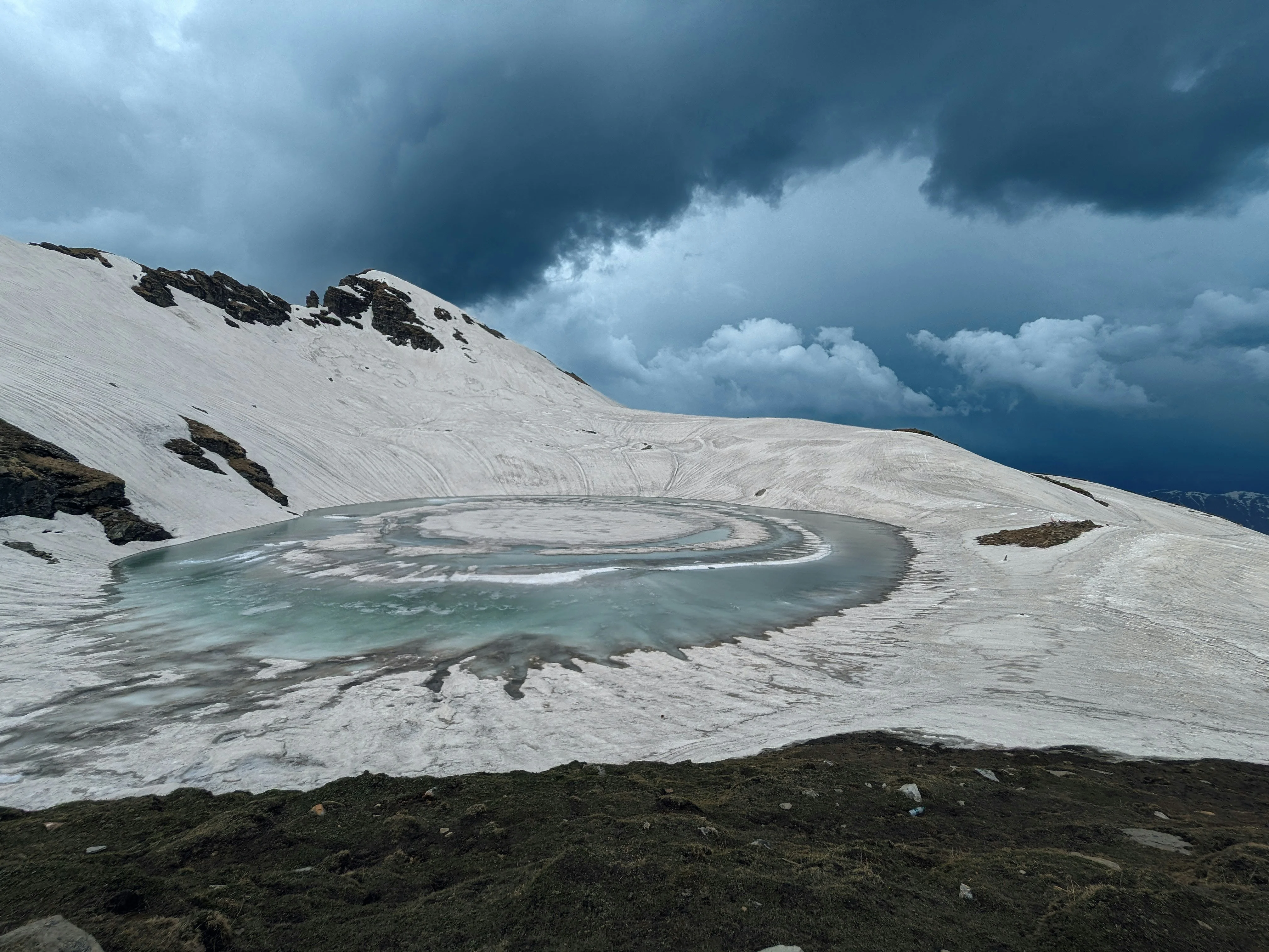
The floating lake phenomenon. The lake sits in a wide, flat highland meadow well above the treeline. When you arrive at the rim and look across, the still water appears to hover among the peaks with no visible basin — an optical illusion that has inspired wonder and mythology for centuries.
Proximity to Manali. The trailhead at Gulaba is only about 22 km from Manali town, making this an ideal extended weekend trek. You can leave Manali on a Friday evening and be back by Monday — a rarity for a trek that tops 4,300 m.
Panoramic mountain views. On clear days, the summit ridge offers sweeping views of the Pir Panjal Range, the Rohtang Pass corridor, and the broad Beas River Valley far below. Few short treks in the region deliver this quality of 360-degree panorama.
Mythological significance. The lake is named after the revered sage Bhrigu, one of the seven great sages (Saptarishis) in Hindu tradition. Local belief holds that Bhrigu meditated on the shores of this lake, and the waters are considered sacred. Many Hindu pilgrims include the lake in their spiritual itinerary during summer.
Beginner-friendly gradient. Despite reaching 4,300 m, the trail involves no technical climbing, glacier crossings, or roped sections. The paths through Jonker Thatch and Rola Kholi are well-worn and clearly marked during the summer season.
Diverse alpine landscapes. The route passes through dense oak and rhododendron forests, vast alpine meadows carpeted with wildflowers in early summer, and the spectacular Rohla Falls — a roaring cascade that is one of the trail's most photogenic highlights.
At a glance
The route at a glance
The Bhrigu Lake trek follows an out-and-back route, beginning and ending at Gulaba (2,990 m), a small settlement on the Manali–Rohtang highway. The total Bhrigu Lake trek distance is approximately 26–30 km round trip, spread comfortably over 4 days.
The Bhrigu Lake trek altitude gain is significant but gradual. From Gulaba at 2,990 m, the trail climbs steadily through forested ridges and open meadows to the summit lake at 4,300 m — a total elevation gain of roughly 1,310 m over two days of ascent. The daily elevation gains are manageable:
- Day 2: Gulaba (2,990 m) → Rola Kholi (3,600 m) — gain of ~610 m over ~8 km
- Day 3: Rola Kholi (3,600 m) → Bhrigu Lake (4,300 m) → return to Rola Kholi — gain of ~700 m over ~10 km (round trip)
- Day 4: Rola Kholi (3,600 m) → Gulaba (2,990 m) — descent of ~610 m over ~8 km
The trail is classified as a non-technical alpine trail, with no roped sections or glacier travel required in the standard summer season.
Key Waypoints on the Trail
- 📍 Gulaba — 2,990 m: The road-accessible trailhead on the Manali–Rohtang highway. Shared taxis and private cabs drop trekkers here. A small HPTDC check-post registers trekkers.
- 📍 Jonker Thatch — ~3,100–3,200 m (approx.): A broad alpine meadow shortly after Gulaba, popular with local shepherds. Offers the first open views of the surrounding ridgelines. (Exact altitude flagged for review.)
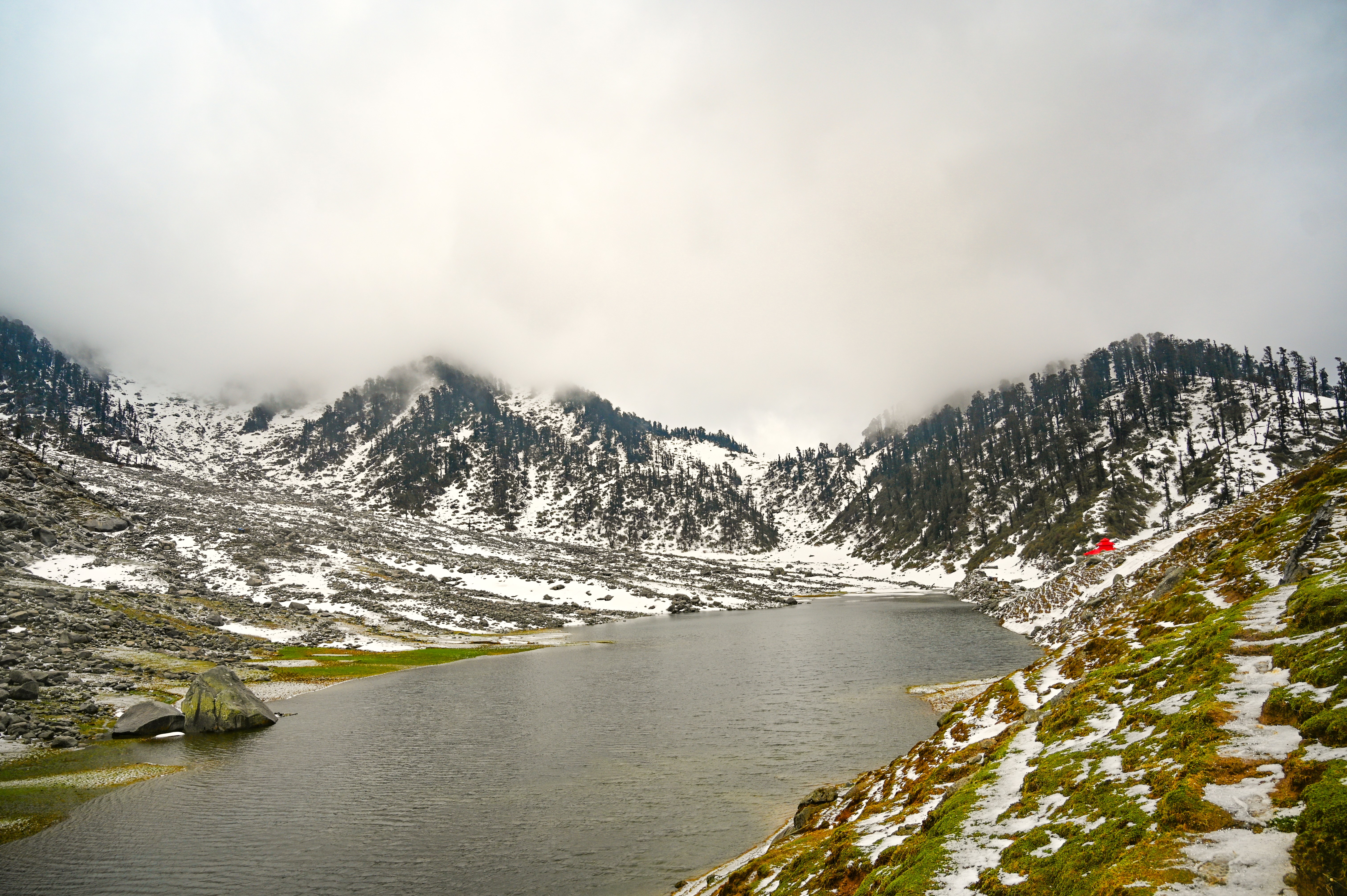
- 📍 Rohla Falls — en route to Rola Kholi: A stunning multi-tiered waterfall visible from the trail, especially dramatic in early summer when snowmelt is at its peak. A must-stop for photography.
- 📍 Rola Kholi — ~3,600 m: The primary campsite for multi-day trekkers. Set in an open meadow with stream water available nearby. Clear nights here offer excellent star-gazing.
- 📍 Bhrigu Lake — 4,300 m: The crown jewel of the trek. A pristine high-altitude lake surrounded by snow-dusted peaks, often partially frozen even in June. The 'floating' optical illusion is best appreciated from the ridge just above the lake.
What each day actually looks like
The standard itinerary for the Bhrigu Lake trek is 4 days, including travel from Manali. This pacing allows adequate acclimatisation and a comfortable Bhrigu Lake camping experience.
Day 1: Manali to Gulaba — Drive + Acclimatisation Walk
- Drive from Manali to Gulaba (~45 minutes to 1 hour, ~22 km)
- Register at the HPTDC/Forest check-post at Gulaba
- Short acclimatisation walk of 1–2 hours in the meadows around Gulaba
- Overnight at Gulaba (camp or basic guesthouse if available)
- Altitude: 2,990 m | Distance driven: ~22 km | Trek distance: ~2–3 km easy walk
Day 2: Gulaba to Rola Kholi (~8 km | 5–6 hours)
- Early morning start after breakfast
- Trail climbs through oak and rhododendron forests before opening into Jonker Thatch meadows
- Pass Rohla Falls — allow 20–30 minutes for photos and rest
- Continue ascending to Rola Kholi campsite (~3,600 m)
- Set up camp, hydrate well, and rest for the summit push
- Altitude gain: ~610 m | Camp altitude: ~3,600 m
Day 3: Rola Kholi to Bhrigu Lake and Back (~10 km | 7–9 hours)
- Summit day — start by 5:30–6:00 AM for best weather and light
- Trail climbs steadily through high alpine meadows; snow patches likely even in June
- Arrive at Bhrigu Lake (~4,300 m) — allow 1–2 hours at the lake for rest, photos, and to soak in the views of the Pir Panjal Range
- Descend the same route back to Rola Kholi for the second night
- Altitude gain: ~700 m | Max altitude: 4,300 m | Camp altitude: ~3,600 m
Day 4: Rola Kholi to Gulaba and Drive to Manali (~8 km descent | 4–5 hours)
- Morning descent through the meadows and forest back to Gulaba
- Arrange shared cab or pre-booked vehicle back to Manali
- Arrive Manali by early afternoon
- Altitude loss: ~610 m | Trek ends at Gulaba, 2,990 m
1-Day Express Option: Can You Do the Bhrigu Lake Trek as a Day Trip from Manali?
For the time-pressed and physically fit, a day-trip version of the Bhrigu Lake trek from Manali is technically possible — but demanding. The plan requires:
- Departure from Manali by 4:00 AM
- Reach Gulaba by 5:00 AM and begin trekking immediately
- Push to Bhrigu Lake and return to Gulaba in one continuous effort (~26 km, 12–14 hours of trekking)
- Back in Manali by evening
This option is NOT recommended for first-time trekkers. The rapid altitude gain without acclimatisation significantly raises the risk of Acute Mountain Sickness (AMS). It is also physically exhausting and leaves no buffer for weather deterioration. If you must attempt it, go with an experienced local guide, start well-hydrated, and turn back without hesitation if any AMS symptoms appear.
When to go
Choosing the right season is critical for both safety and experience. Here is a season-by-season breakdown for Bhrigu Lake trek weather:
Summer: May–June (Most Popular)
This is peak season and the most recommended window for most trekkers. Snow patches linger on the upper trail and around the lake, wildflowers blanket the meadows in colour, and Rohla Falls is at its most spectacular. Weather is generally stable in the mornings, though afternoon thunderstorms can develop. Expect the trail to be busy with fellow trekkers.
Monsoon: July–August (Avoid)
The southwest monsoon brings heavy rainfall, landslide risk on approach roads, leeches on the lower trail, and poor visibility. The Manali–Rohtang road corridor is particularly susceptible to road blockages. We strongly advise avoiding this window entirely.
Post-Monsoon: September–October (Best for Photography)
Skies are crystal clear after the monsoon washes the atmosphere clean. Views of the Pir Panjal Range are sharpest in this window. The meadows turn golden and russet, and temperatures are crisp but manageable. Snowfall can begin from late October — check forecasts closely.
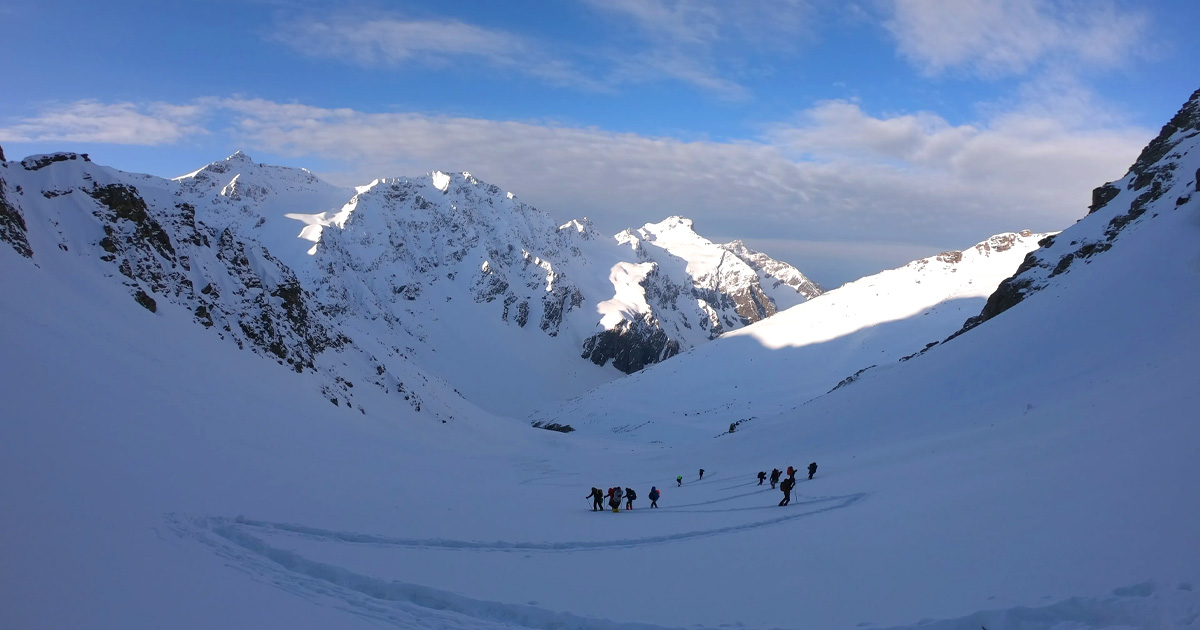
Winter: November–April (Expert Only)
The Bhrigu Lake trek in winter is dramatic — the lake freezes solid and the entire landscape transforms into a high-altitude snowscape. However, this window carries serious risks: trail route-finding requires experience and navigation skills, temperatures can drop to -20°C or below at camp, and avalanche risk exists on certain slopes. Only highly experienced winter trekkers with proper cold-weather gear should attempt this.
| Season | Months | Conditions | Recommended? |
|---|---|---|---|
| Summer | May–June | Snow patches, wildflowers, peak footfall | ✅ Best for most trekkers |
| Monsoon | July–August | Heavy rain, landslides, leeches | ❌ Avoid |
| Post-Monsoon | September–October | Crystal skies, golden meadows | ✅ Best for photography |
| Winter | November–April | Frozen lake, -20°C, avalanche risk | ⚠️ Experts only |
Is this trek right for you?
The Bhrigu Lake trek difficulty is rated Easy-to-Moderate — making it one of the most approachable high-altitude treks in the Indian Himalayas.
Who can do it: Healthy adults with basic fitness and no prior trekking experience can complete this trek comfortably with the standard 4-day itinerary. There is no technical climbing, no glacier travel, and no exposed ridges.
Fitness preparation (recommended 4-week plan):
- Weeks 1–2: 30-minute brisk walks or jogs, 5 days a week; stair climbing
- Weeks 3–4: Increase to 45–60-minute runs or hikes on varied terrain; add loaded pack walks (8–10 kg) on weekends
Altitude concern: At 4,300 m, Acute Mountain Sickness (AMS) is a real possibility, especially for trekkers ascending from sea-level cities. The 4-day itinerary is designed to allow gradual acclimatisation. See our altitude sickness prevention guide for detailed advice on recognising and responding to AMS.
Children: Recommended minimum age is 12 years, with parental assessment of physical readiness. Younger children should not be taken above 3,500 m without medical guidance.
Senior trekkers: The trail is suitable for healthy seniors (up to approximately 65–70 years) with prior trekking experience. Consult your physician before departure and carry any prescribed medications.
What permits you need
The Bhrigu Lake trek permit process is straightforward — no Inner Line Permit (ILP) is required for this trek, as the trail does not enter a restricted border zone.
What you need:
- Forest/National Park Entry Fee: Payable at the Gulaba check-post. Approximately INR 50–100 per person for the forest area entry. (Exact 2026 fee flagged for review — verify at the Gulaba barrier on arrival.)
- HPTDC Check-Post Registration: Trekkers are logged at the Gulaba barrier. Carry a valid government-issued photo ID (Aadhaar card, passport, or driving licence) — this is mandatory.
- Camera/video fee: A nominal camera fee may apply if using professional equipment.
Where to get permits: All registration and fee payment happens on-site at the Gulaba check-post before you start trekking. No advance online booking is required.
For a broader overview of permits across Himachal Pradesh, see our Himachal Pradesh trekking permits guide.
What this trek will cost you
Here is a realistic Bhrigu Lake trek cost breakdown for both DIY and guided approaches in 2026:
DIY Budget Estimate (per person):
| Item | Estimated Cost (INR) |
|---|---|
| Shared cab, Manali to Gulaba (one way) | 300–500 |
| Shared cab, Gulaba to Manali (return) | 300–500 |
| Camping gear rental (tent, sleeping bag, poles) per day × 3 days | 1,500–2,000 |
| Food (meals + snacks) per day × 4 days | 2,000–2,500 |
| Forest entry permit | ~100 |
| Miscellaneous (porter tips, emergency snacks) | 500–1,000 |
| Total DIY estimate | ~4,700–6,600 |
(All cost figures are estimates for 2026 and flagged for review — actual costs may vary.)
Guided Package (per person):
Organised trek packages from reputable operators typically cost INR 6,000–12,000, inclusive of guide, camping equipment, meals, permits, and transport from Manali. Well-regarded operators for this trek in 2026 include:
- Indiahikes
- Trek The Himalayas
- The Hiking Tribe
(Operator package prices flagged for review — confirm current 2026 pricing directly with operators before booking.)
Budget Tips for Solo Trekkers
Addressing the Bhrigu Lake trek solo budget:
- Shared cabs from the Manali old bus stand are the cheapest way to reach Gulaba. Arrive early (6–7 AM) to share with other trekkers headed to Rohtang/Gulaba.
- Group joining: Platforms like Thrillophilia, local Facebook trekking groups (search 'Manali Trekkers 2026'), and the Indiahikes community board allow solo trekkers to join existing groups, reducing guide and transport costs.
- Renting vs. buying gear: For a 3–4 day trek, renting is almost always more economical. Multiple gear rental shops operate on Manali's Old Manali Road. A -10°C sleeping bag rents for approximately INR 200–300/day. See our best trekking shoes India guide for footwear advice — good boots are worth buying rather than renting.
What to pack
Pack smart for the Bhrigu Lake trek gear list — the goal is light but complete.
Clothing (layering system):
- Moisture-wicking thermal base layer (top and bottom)
- Mid-layer fleece or down jacket
- Waterproof and windproof outer shell jacket
- Trekking trousers (convertible zip-off style recommended)
- Warm hat, sun hat, and UV-protective sunglasses
- Lightweight gloves and a heavier pair for summit day
Footwear:
- Ankle-support waterproof trekking boots (broken in before the trek)
- Trekking gaiters (essential in snow patches, May–June)
- Camp sandals or light shoes for evenings
Camping:
- Sleeping bag rated to -10°C (mandatory for Rola Kholi camp)
- Trekking poles (highly recommended for descent)
- Headlamp with spare batteries
Navigation:
- Downloaded offline maps (Maps.me or Gaia GPS with Kullu District loaded)
- Basic compass
- Printed route overview as backup
Health & Safety:
- Personal first-aid kit (blister pads, antiseptic, bandages, pain relief)
- Diamox (acetazolamide) — consult your doctor before the trek; useful for AMS prevention above 3,500 m
- ORS sachets for rehydration
- Sunscreen SPF 50+ and lip balm (UV intensity is high at altitude)
- Water purification tablets or filter
Documents:
- Original government photo ID + photocopy
- Permit/registration receipt from Gulaba check-post
- Emergency contact card (carried separately from phone)
📦 Affiliate card slot: Best trekking shoes for Bhrigu Lake →
Recommended gear for this trek
Staying safe on the mountain
Safety on the Bhrigu Lake trek comes down to three pillars: altitude awareness, weather respect, and trail discipline.
Acute Mountain Sickness (AMS):
Symptoms include persistent headache, nausea, dizziness, fatigue, and loss of appetite. If symptoms appear above 3,500 m, do not ascend further. If symptoms worsen after 30–60 minutes of rest, descend immediately — this is the only reliable treatment in the field. Read our full altitude sickness prevention guide.
Weather changes:
Afternoon thunderstorms are common throughout the trekking season, particularly in June. Always aim to reach your campsite by 1:00–2:00 PM. If you are above 4,000 m and see storm clouds building, begin your descent without delay. Lightning on exposed ridges is a serious hazard.
Stay on the marked trail:
In early season (May), snow can obscure the trail above Rola Kholi. Do not proceed in whiteout or low-visibility conditions without an experienced guide or GPS navigation.
Trek buddy system:
Solo trekkers should strongly consider joining a group or hiring a local guide from Manali or Gulaba. If trekking solo, inform your accommodation in Manali of your exact itinerary and expected return date.
Emergency contacts:
- 🚨 Manali Police: 01902-252340
- 🚑 Zonal Hospital Manali: Located in Manali town — the nearest facility with emergency care capability
- HRTC helpline: Check the official HRTC website for the current 2026 helpline number
- Mountain Rescue (HPPDTSC/ITBP): Notify the Gulaba check-post if a trekker is missing or in distress
Similar treks to explore
Kareri Lake Trek: Complete Guide for 2026
Plan your Kareri Lake trek with our 2026 guide covering route, difficulty, permits, cost, packing list, best time to visit, and day-wise itinerary.
Buran Ghati Trek: Complete Guide 2026
The Buran Ghati Trek is a difficult 40 km trail in Himachal Pradesh crossing a 4,700 m pass with India's only glacier rappel descent on a mainstream trek.
Indrahar Pass Trek: Routes, Difficulty & Best Time
Indrahar Pass trek is a moderate-to-difficult 4-day route in the Dhauladhar range, starting from McLeod Ganj and reaching 4,342 m (14,245 ft). Best done September–October.
Common questions answered
Bhrigu Lake sits at approximately 4,300 metres (14,100 feet) above sea level in the Kullu District of Himachal Pradesh. It is one of the highest easily accessible lakes in the Manali region and is considered a high-altitude alpine lake by trekking standards.