Why Dayara Bugyal Trek is on every trekker's list
The Dayara Bugyal trek is a 22 km round-trip trail in Uttarkashi, Uttarakhand, reaching 3,660 m (12,000 ft) — rated Easy to Moderate and accessible year-round including winter snowshoeing.
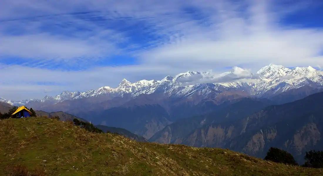
There are alpine meadows in the Garhwal Himalayas, and then there is Dayara Bugyal. Sprawling across a tilted plateau at approximately 3,660 m (12,000 ft) in Uttarkashi district, Uttarakhand, this vast grassland is one of the most photogenic and accessible high-altitude destinations in India. On clear days the meadow's open bowl frames a stunning arc of peaks—Bandarpunch, Draupadi ka Danda, and the Gangotri group—in a panorama that stops experienced trekkers in their tracks.
What makes Dayara Bugyal unusual is that it draws trekkers across all four seasons. In spring, rhododendron forests burn red and pink on the lower slopes. In autumn, the golden meadow glows under crystal-clear Himalayan skies. And from December through February, the entire plateau disappears under deep snow, transforming into a snowshoeing destination unlike almost anything else in North India. Whether you are lacing up your boots for the first time or returning for a winter adventure, the Dayara Bugyal trek deserves a place on your itinerary.
If you are browsing Uttarakhand treks and trying to narrow down your options, here is why Dayara Bugyal consistently earns top marks.
Panoramic views without the technical climb. From Bakaria Top (~3,810 m), the optional high point of the trek, you get a near-360° view of the western Garhwal Himalayas. Bandarpunch (6,316 m) and Draupadi ka Danda dominate the north, while the Gangotri peaks form a jagged wall to the northeast. Very few beginner-accessible treks in Uttarakhand offer this quality of Himalayan vista.
Easy access from Dehradun. The trailhead at Barsu village is roughly 7–8 hours by road from Dehradun via Uttarkashi. No internal flights, no multi-day bus marathons—a single long drive and you are at the start line. For details on reaching Uttarkashi, see our how to reach Uttarkashi guide.
Genuine beginner-friendliness. Unlike technically demanding Uttarakhand treks such as Kedarkantha (which involves steeper snowfields) or Har Ki Dun (longer daily distances), Dayara Bugyal asks only for consistent effort over moderate gradients. First-time trekkers with a few weeks of preparatory fitness work manage it comfortably.
The meadow-plus-snow combination. Even in the trekking shoulder seasons (late November, early April), patches of snow sit alongside open green meadow. In full winter, the entire Bugyal becomes a snowscape. This is the rare trek where you can choose your version of the same landscape.
Solitude on a weekday. While Dayara Bugyal has grown in popularity, mid-week and off-season windows still offer the silence of an open sky above treeline—a sensation increasingly hard to find on more commercialised Uttarakhand trails.
At a glance
The route at a glance
The standard route begins and ends at Barsu village (~2,800 m), roughly 26 km from Uttarkashi town by road. The trail climbs through dense forest, opens into intermediate meadows, passes the serene Barnala Tal lake, and then crests onto the broad plateau of Dayara Bugyal. The optional extension to Bakaria Top adds modest extra altitude and significant panoramic reward.
- Total distance: ~22 km round trip
- Altitude range: ~2,800 m (Barsu) to ~3,660 m (Dayara Bugyal) / ~3,810 m (Bakaria Top)
- Trail character: Mixed forest, stream crossings, open meadow, gentle but sustained ascent
For a full comparison with similar meadow treks, see our Brahmatal Trek Guide.
Barsu Village to Gui Meadow
Distance: ~4 km | Altitude gain: ~2,800 m to ~3,100 m | Time: 2.5–3 hrs
The trail leaves Barsu on a well-worn path that quickly enters a mixed forest of oak, rhododendron, and Himalayan maple. This section is the most botanically rich of the trek—in April and May, rhododendrons flower in vivid reds and pinks overhead. There are two or three small stream crossings (straightforward in most seasons; exercise care in monsoon). The forest thins progressively and the trail emerges at Gui Meadow, a sloping grassland with good water sources and a natural first campsite. Gui is also where porters and mule teams from Barsu typically pause.
Gui Meadow to Barnala Tal
Distance: ~3 km | Altitude gain: ~3,100 m to ~3,500 m | Time: 2–2.5 hrs
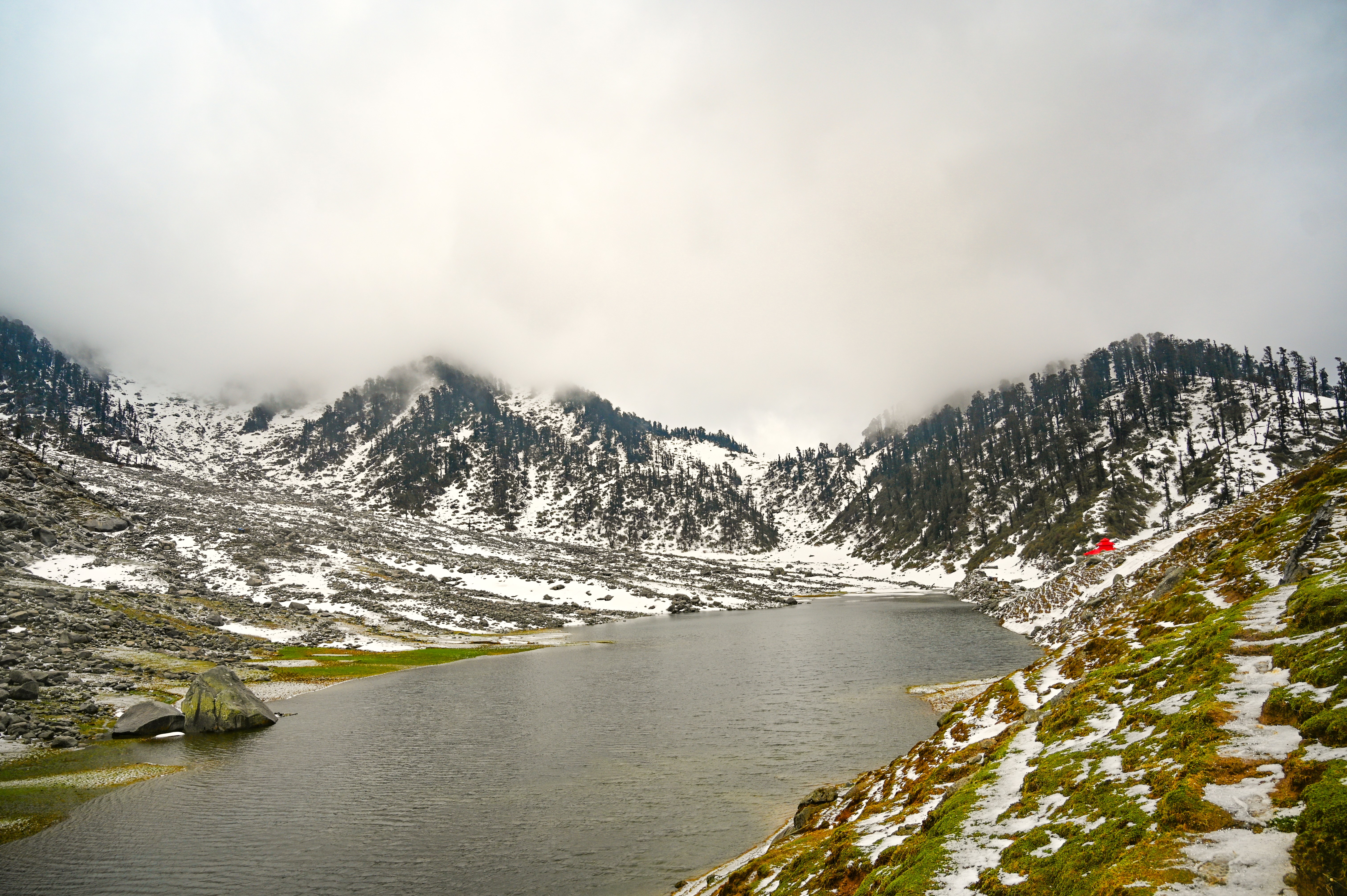
From Gui the treeline recedes and the trail climbs more openly through high pasture. The gradient is steady but never severe. Barnala Tal is a small lake (the name translates roughly to 'forest lake') sitting at approximately 3,500 m. On calm mornings, it reflects the surrounding peaks in near-perfect mirror images—one of the most photographed spots on the trek. Camping near the lake is popular and the site is well established. Water from the lake should be purified before drinking.
Barnala Tal to Dayara Bugyal and Bakaria Top
Distance: ~2 km | Altitude gain: ~3,500 m to ~3,660 m (Dayara) / ~3,810 m (Bakaria Top) | Time: 1.5–2 hrs to Dayara; add 45–60 min return for Bakaria Top
This final section is the most dramatic. The trail leaves Barnala Tal and climbs the last ridge onto the Dayara plateau—and suddenly, the world opens up. The meadow rolls away in all directions, bounded by peaks rather than ridgelines. Most trekkers pause here for photographs and a long rest.
For Bakaria Top, a further climb of roughly 150 m of altitude from the meadow edge leads to the highest accessible viewpoint on this route. The 360° panorama from Bakaria Top includes Bandarpunch massif, Draupadi ka Danda, peaks of the Gangotri group, and on clear days, hints of the Kedarnath range far to the south. The side trip is highly recommended if weather and energy permit. Descend back to Barnala Tal or Gui for the night.
What each day actually looks like
The following 4-night / 5-day plan (plus a Day 0 travel day) is the standard format for most trekkers and operators.
Day 0 — Dehradun to Barsu Village
- Drive: Dehradun → Uttarkashi (~5–6 hrs on NH34/NH108) → Barsu (~1.5 hrs by local jeep)
- Total drive: ~7–8 hrs
- Arrive Barsu (2,800 m); check into guesthouse or camp; acclimatise and rest
- Dinner and early sleep recommended
Day 1 — Barsu to Gui Meadow Camp
- Distance: ~4 km | Altitude: 2,800 m → ~3,100 m
- Walking time: 2.5–3 hrs
- Morning start after breakfast; permit check at Barsu check post
- Forest trail through oak and rhododendron; stream crossings
- Camp at Gui Meadow (~3,100 m); afternoon free to explore
Day 2 — Gui Meadow to Barnala Tal Camp
- Distance: ~3 km | Altitude: ~3,100 m → ~3,500 m
- Walking time: 2–2.5 hrs
- Short but meaningful ascent through open high pasture
- Arrive Barnala Tal by late morning; ample time for photography and rest
- Camp at Barnala Tal (~3,500 m); watch the sunset on surrounding peaks
Day 3 — Barnala Tal to Dayara Bugyal & Bakaria Top, return to camp
- Distance: ~4 km round trip from Barnala Tal | Max altitude: ~3,810 m (Bakaria Top)
- Walking time: 4–5 hrs including Bakaria Top detour
- Summit day: early start, push to Dayara Bugyal plateau then Bakaria Top
- Return to Barnala Tal or descend to Gui for camp (teams vary in preference)
Day 4 — Descent to Barsu
- Distance: ~7–9 km (Barnala/Gui to Barsu) | Altitude: ~3,500/3,100 m → 2,800 m
- Walking time: 3–4 hrs
- Steady descent through forest; arrive Barsu by early afternoon
- Overnight in Barsu guesthouse
Day 5 — Drive back to Dehradun
- Depart Barsu after breakfast
- Uttarkashi → Dehradun: ~5–6 hrs
- Arrive Dehradun by early evening
When to go
Dayara Bugyal is a genuine four-season destination, though each window offers a dramatically different experience.
Spring (April–June): Rhododendron forests at Barsu and along the Gui trail are in full bloom by mid-April, creating vivid colour contrasts against lingering snow patches at higher elevations. Skies are generally clear in the early morning. June can bring pre-monsoon clouds and afternoon haze. This is an excellent window for trekkers who want colour and relatively moderate temperatures.
Monsoon (July–August): The Uttarakhand monsoon brings heavy rainfall, landslide risk on the road between Uttarkashi and Barsu, and leeches in the forest section. Most experienced guides advise against the trek in this window. The meadow is lush green but visibility of peaks is severely limited. We recommend avoiding this season.
Autumn (September–November): Widely regarded as the finest window for the Dayara Bugyal trek. Post-monsoon skies are exceptionally clear, meadow grasses turn golden, and the surrounding peaks appear in razor-sharp detail. October and early November offer near-perfect conditions. This is peak season—expect more company on the trail and book campsites in advance. See also our Kedarkantha Trek Guide for comparison in this season.
Winter — The Dayara Bugyal Winter Trek (December–March): This is where Dayara Bugyal earns a separate chapter in any serious trekker's notebook. From late December, the entire plateau fills with snow, and the trail between Barnala Tal and the Bugyal becomes a snowshoeing route. Temperatures at camp can drop to -10°C or below overnight. The meadow under snow—empty, white, and ringed by Himalayan giants—is genuinely surreal. A guided winter trek is strongly recommended; see our best winter treks in Uttarakhand roundup for context. Microspikes or snowshoes, a -10°C rated sleeping bag, and layered thermals are essential.
| Season | Months | Experience | Recommended? |
|---|---|---|---|
| Spring | April–June | Rhododendron blooms, mixed skies | ✅ Yes |
| Monsoon | July–August | Lush but poor visibility, landslide risk | ❌ Avoid |
| Autumn | September–November | Clear skies, golden meadows, peak views | ✅ Best |
| Winter | December–March | Snow-covered plateau, snowshoeing | ✅ Yes (guided) |
Is this trek right for you?
Overall rating: Easy to Moderate
The maximum altitude of the standard route is ~3,660 m at Dayara Bugyal, rising to ~3,810 m at Bakaria Top. Daily walking is 3–7 km over 2.5–5 hours on most days, with gradients that are sustained but rarely steep. There is no technical climbing, no scrambling, and no route-finding complexity on clear days.
This profile makes Dayara Bugyal one of the most beginner-appropriate treks in Uttarakhand. The main challenge is the combination of sustained walking and moderate altitude—not the terrain itself.
Recommended preparation (4 weeks before the trek):
- 30–40 minutes of brisk walking or light jogging daily
- Stair climbing sessions (3 × per week) to build leg endurance
- Basic stretching for calves, hamstrings, and lower back
Who can attempt this trek?
- First-time trekkers with reasonable cardiovascular fitness
- Children above 10 years (with parental supervision and a conservative pace)
- Adults below 60 years in good general health (seniors above 60 should consult a doctor and consider fitness carefully)
- Trekkers with no prior high-altitude exposure should read about AMS before departing
For comprehensive gear guidance, see our high-altitude trekking gear guide.
What permits you need
A forest entry permit from the Uttarkashi Forest Division is required for the Dayara Bugyal trek. As of the 2026 trekking season, the fee is approximately INR 150–200 per person per day.
Where to obtain:
- At the Barsu village check post on the morning of Day 1 (most common method)
- At the Uttarkashi Forest Division office in Uttarkashi town (advisable if trekking independently in off-season when the check post may be unstaffed)
What you need:
- Original government-issued photo ID (Aadhaar, passport, or driving licence)
- Passport-size photographs (carry 2 spares)
- Camping permit is included in or issued alongside the forest entry permit for overnight stays
No separate AMAI or IMF mountaineering permit is required for this trek, as Dayara Bugyal does not cross any restricted or high-altitude mountaineering zone.
Permit rules can change seasonally. For the most current information, see our Uttarakhand forest permits guide or call the Uttarkashi Forest Division directly before your trip.
What this trek will cost you
DIY vs. Guided Package — Cost Comparison
The table below reflects estimated 2026 costs. DIY figures assume a group of 2–3 sharing transport and camping gear rentals. Guided package rates are indicative of mid-range operators; budget and premium operators will vary.
Note: All costs flagged for review — 2026 rates should be verified with operators and transport providers closer to your travel date.
| Cost Head | DIY (INR) | Guided Package (INR) |
|---|---|---|
| Transport (Dehradun–Barsu–Dehradun) | 2,500–3,500 | Included |
| Permits (4 days) | 600–800 | Included |
| Accommodation / Camping | 1,200–1,500 (tent rental ~300/night) | Included |
| Food (4 days on trek) | 1,600–2,400 | Included |
| Guide / Porter | 800–1,500 (optional) | Included |
| Gear Rental (poles, sleeping bag etc.) | 500–1,000 | Partially included |
| Total (per person) | ~6,000–9,000 | ~8,000–14,000 |
DIY: Best for experienced trekkers comfortable with navigation, self-camping, and managing permits independently. Saves money but requires advance planning.
Guided Package: Recommended for first-timers, solo trekkers, and winter season trekkers. Operators handle permits, camping logistics, meals, and emergency protocols. The price premium buys significant peace of mind.
What to pack
Clothing (layering system)
- Moisture-wicking base layer (synthetic or merino wool)
- Mid-layer fleece or down jacket
- Waterproof and windproof outer shell
- Thermal innerwear (essential for winter trek)
- Trekking trousers (convertible zip-off recommended for spring/autumn)
- Warm hat, sun hat, neck gaiter, gloves (liner + outer for winter)
Footwear
- Ankle-support waterproof trekking shoes (broken in before the trek)
- Gaiters (essential in winter and early spring for snow sections)
- Camp sandals / flip-flops
Trekking Gear
- Trekking poles (highly recommended on descent)
- 40–50 L daypack with rain cover
- Sleeping bag (-10°C rated for winter; -5°C adequate for autumn/spring)
- Headlamp with spare batteries
- Microspikes or crampons (mandatory for winter trek)
- Snowshoes (if attempting winter trek with heavy snow cover — usually provided by operators)
Documents
- Original government-issued photo ID
- Forest permit (carry copy and original)
- Travel/trekking insurance documents
- Emergency contact list (printed copy)
Health & Essentials
- Sunscreen SPF 50+ (UV intensity is high at altitude)
- Lip balm with SPF
- Water purification tablets or filter
- Personal first-aid kit (bandages, antiseptic, blister plasters, ORS sachets)
- Personal medications (consult doctor about Diamox for altitude)
- Energy bars, nuts, and trail snacks for summit day
- Minimum 2 × 1-litre water bottles or a hydration bladder
For a detailed gear checklist, visit our high-altitude trekking gear guide.
Recommended gear for this trek
Staying safe on the mountain
Acclimatise on arrival night. Spend Day 0 at Barsu (~2,800 m) without rushing upward. A light walk around the village in the evening helps your body begin adjusting.
Hydrate consistently. Drink 3–4 litres of water per day on the trail. Dehydration accelerates Acute Mountain Sickness (AMS) symptoms and is the most common preventable mistake on Himalayan treks.
Know AMS warning signs. The early symptoms of AMS include persistent headache, nausea, fatigue disproportionate to effort, and loss of appetite. Confusion, loss of coordination, or breathlessness at rest are serious warning signs requiring immediate descent. The golden rule: never ascend with unresolved AMS symptoms.
Diamox (Acetazolamide): Some trekkers use this prescription medication to aid acclimatisation. Use only on a doctor's explicit advice and prescription—it is not a substitute for proper acclimatisation.
Weather changes rapidly above treeline. Even in October, afternoon clouds can build quickly and bring rain, hail, or snow. Always carry your waterproof shell in your daypack, regardless of the morning forecast.
Inform someone of your itinerary. Leave a day-wise plan with a responsible contact at home and with your guesthouse owner in Barsu. Mobile coverage is limited beyond Barsu village—do not rely on your phone for navigation or emergency communication above the trailhead.
Emergency contacts:
- Uttarkashi District Hospital: +91-1374-222026
- SDRF (State Disaster Response Force) Uttarkashi: +91-1374-222032
- Local trek guide or operator's emergency line (obtain before departure)
Similar treks to explore
Kareri Lake Trek: Complete Guide for 2026
Plan your Kareri Lake trek with our 2026 guide covering route, difficulty, permits, cost, packing list, best time to visit, and day-wise itinerary.
Buran Ghati Trek: Complete Guide 2026
The Buran Ghati Trek is a difficult 40 km trail in Himachal Pradesh crossing a 4,700 m pass with India's only glacier rappel descent on a mainstream trek.
Indrahar Pass Trek: Routes, Difficulty & Best Time
Indrahar Pass trek is a moderate-to-difficult 4-day route in the Dhauladhar range, starting from McLeod Ganj and reaching 4,342 m (14,245 ft). Best done September–October.
Common questions answered
Approximately 22 km round trip from Barsu village. Each one-way leg covers roughly 10–11 km spread across 2–3 days of trekking, making daily distances very manageable for beginners.