
Why Deoriatal Chandrashila Trek is on every trekker's list
Few short Himalayan treks pack as many memorable moments into a single route as the Deoriatal Chandrashila trek. In just four to five days you will stand at the edge of Deoriatal lake — its glassy surface mirroring the snow-draped Chaukhamba peaks — then push through rhododendron forests to the ancient Tungnath temple at 3680m, and finally scramble to the Chandrashila summit at 4090m for a 360-degree panorama that stretches from Kedarnath to Nanda Devi.
Located in Rudraprayag district, Uttarakhand, the trail covers approximately 26 km one way and gains roughly 1740m in elevation. With no technical climbing sections and a gradual ascent profile, it sits comfortably in the easy-moderate bracket — making it one of the best beginner-friendly Himalayan treks in India. Delhi is roughly 450 km away, Rishikesh just 220 km, and the 2026 trekking season is already drawing enthusiastic crowds. Read on for everything you need to plan your trip.
There are hundreds of Himalayan trails, so what makes this one stand out?
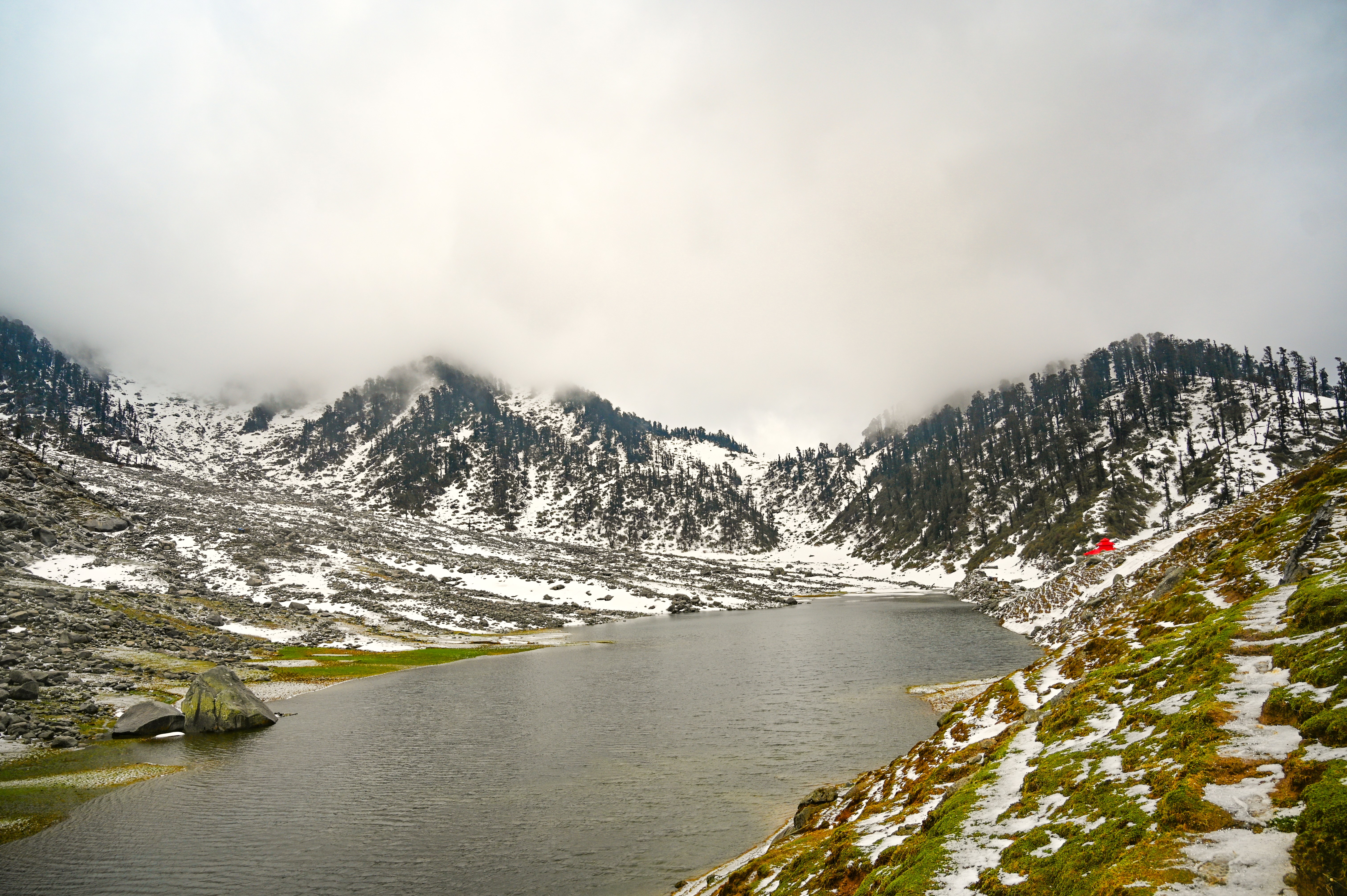
1. The Deoriatal lake reflection — At 2438m, this small forest lake produces one of the most photographed reflections in the Indian Himalayas: the Chaukhamba massif shimmering on the water at dawn. Arrive early and you will have it almost to yourself.
2. World's highest Shiva temple — Tungnath temple at 3680m is widely cited as the highest Shiva temple on Earth. Built in the Nagara architectural style, it is one of the Panch Kedar shrines and carries enormous cultural and religious significance for pilgrims and trekkers alike.
3. Chandrashila summit panorama — The 4090m summit offers unobstructed sightlines to Kedarnath Peak, Nanda Devi, Trishul, Neelkanth, and Chaukhamba. On clear autumn mornings the view extends over 200 km of Himalayan ridgeline.
4. Accessibility — Base village Sari is roughly 220 km from Rishikesh (7–8 hours by road) and about 450 km from Delhi. No flights or trains into remote territory — just a highway drive and a shared taxi.
5. Beginner-friendly — Gradual elevation gain, well-marked trails, established camping and guesthouse infrastructure, and the absence of any technical section mean that a fit first-timer can complete this trek safely.
6. Doable in a long weekend — The compressed 3-day option lets you experience Deoriatal, Chopta, Tungnath, and Chandrashila over a three-day holiday, though it is more demanding. Most trekkers prefer four to five days.
For a broader shortlist, see our guide to the best treks in Uttarakhand.
At a glance
The route at a glance
The classic route runs: Sari Village → Deoriatal Lake → Rohini Bugyal → Baniya Kund → Chopta → Tungnath → Chandrashila Summit.
Total one-way distance is approximately 26 km, though most trekkers treat it as a point-to-point route with vehicle return or a partial loop. Elevation rises from Sari village at 2350m to the Chandrashila summit at 4090m — a net gain of about 1740m spread over three to four walking days.
The trail character changes distinctly with altitude:
- Sari to Deoriatal (0–3 km): Paved/stone steps through oak and rhododendron forest. Short and steep but quickly rewarding.
- Deoriatal to Rohini Bugyal (3–9 km): Dense mixed forest gives way to open meadows. The trail undulates gently through the Kedarnath Wildlife Sanctuary.
- Rohini Bugyal to Baniya Kund (9–15 km): Descending section through forest, crossing small streams before a gradual climb resumes.
- Baniya Kund to Chopta (15–18 km): Motor road proximity. Chopta is often called the "Mini Switzerland of Uttarakhand" — a cluster of meadow camps at 2680m.
- Chopta to Tungnath to Chandrashila (18–24 km): A 3.5 km stone-paved ascent climbs steeply to Tungnath, then a further 1 km rocky scramble to the summit.
📍 Route Map Visual: A downloadable GPX track and illustrated trail map are available on our Chopta trek guide page. Offline, use Maps.me with the Uttarakhand region downloaded in advance.
Key Waypoints and Elevation Profile
| Waypoint | Elevation | Cumulative Distance (approx.) |
|---|---|---|
| Sari Village | 2350m | 0 km |
| Deoriatal Lake | 2438m | 3 km |
| Rohini Bugyal | 3200m | 9 km |
| Baniya Kund | 2800m | 15 km |
| Chopta | 2680m | 18 km |
| Tungnath Temple | 3680m | 21.5 km |
| Chandrashila Summit | 4090m | 23 km |
Note: Distances are approximate field measurements. Actual GPS tracks may vary by ±5–10% depending on trail conditions and seasonal route variations. Figures flagged for verification.
The base camp is Sari Village, Rudraprayag district, Uttarakhand.
By Road (Recommended)
Haridwar → Rishikesh → Devprayag → Srinagar (Garhwal) → Rudraprayag → Ukhimath → Sari
- Distance from Rishikesh: approx. 220 km
- Drive time: 7–8 hours (road conditions and seasonal traffic apply)
- Options: Private taxi (₹3,500–5,000 per vehicle), shared sumo/taxi from Rishikesh bus stand
- See our detailed how to reach Chopta from Delhi guide
By Bus
GMOU or UPSRTC buses run from Rishikesh/Haridwar to Ukhimath. From Ukhimath, take a shared taxi or local vehicle to Sari (approx. 12 km, 30–40 minutes).
Nearest Railway Station
Haridwar Junction or Rishikesh Railway Station. Haridwar is better connected to major cities.
Nearest Airport
Jolly Grant Airport, Dehradun — approximately 240 km from Sari (4.5–5 hours by road). Delhi IGI Airport connects to Dehradun with multiple daily flights.
💡 Tip: If starting from Delhi, take an overnight train or bus to Haridwar/Rishikesh, arriving early morning. This allows you to begin the road journey to Sari immediately and reach Deoriatal the same evening.
What each day actually looks like
5-Day / 4-Night Recommended Itinerary
Day 1 — Travel Day: Haridwar/Rishikesh to Sari Village + Trek to Deoriatal
- Depart Haridwar or Rishikesh by 5–6 AM by shared taxi or private vehicle.
- Drive through Devprayag, Srinagar (Garhwal), Rudraprayag, and Ukhimath to reach Sari village (approx. 7–8 hours).
- After lunch at Sari, begin the 3 km ascent to Deoriatal through oak-rhododendron forest — allow 1.5 to 2 hours.
- Check into forest rest house or designated camping zone.
- Evening: walk to the lake edge for sunset reflections; night sky gazing (minimal light pollution).
- Camp altitude: 2438m. Walking time: 1.5–2 hours.
Day 2 — Deoriatal to Chopta via Rohini Bugyal
- Early start (6:30 AM) for dawn reflections at the lake, then breakfast and depart.
- Trail climbs through dense forest before opening into the spectacular Rohini Bugyal meadows at 3200m — a highlight in itself.
- Descend gradually through forest to Baniya Kund (2800m), a natural rest stop with a stream.
- Continue to Chopta (2680m), arriving by early afternoon.
- Check into guesthouse or tent camp; rest and acclimatise.
- Distance: approx. 12–15 km. Walking time: 5–6 hours. Moderate.
Day 3 — Chopta to Chandrashila Summit and Return to Chopta
- Wake at 4 AM; begin summit push by 4:30–5 AM to catch sunrise from Chandrashila.
- 3.5 km paved ascent to Tungnath temple (3680m) — allow 2–2.5 hours.
- Offer prayers at Tungnath, then take the rocky 1 km trail to Chandrashila summit (4090m) — 45 minutes to 1 hour.
- On a clear day: panoramic views of Kedarnath, Nanda Devi, Trishul, Neelkanth, and Chaukhamba.
- Descend before noon — afternoon clouds and changing weather are common above 3500m.
- Return to Chopta by midday; rest afternoon.
- Total distance: 6 km round trip. Walking time: 4–5 hours. Moderate-strenuous.
Day 4 — Chopta to Sari (Return Trek) or Rest/Explore
- Option A (full route): Retrace trail from Chopta back to Sari via Baniya Kund — a long but achievable day (approx. 15 km, 6–7 hours).
- Option B: Arrange vehicle pickup from Chopta (motor road accessible) and drive to Sari or directly to Ukhimath/Rishikesh.
- Stay overnight in Sari or begin drive back.
Day 5 — Drive Back to Haridwar/Rishikesh/Delhi
- Early morning departure from Sari.
- Reach Rishikesh by afternoon (7–8 hours), Delhi by evening.
Alternate 3-Day Itinerary for Long Weekend
For trekkers with limited time, a compressed version is possible — but note it is considerably more strenuous and leaves little buffer for bad weather.
| Day | Segment | Details |
|---|---|---|
| Day 1 | Haridwar → Sari → Deoriatal | Pre-dawn departure from Haridwar; arrive Sari by noon; trek to Deoriatal |
| Day 2 | Deoriatal → Chopta → Chandrashila → Chopta | Long day: trek to Chopta via Rohini Bugyal, then immediate ascent to summit and return to Chopta. 18–20 km, 8–10 hrs |
| Day 3 | Chopta → Haridwar (by vehicle) | Drive back via Ukhimath |
⚠️ The 3-day version is not recommended for people with no prior trekking experience. The middle day is exceptionally long and any weather delay could strand you at altitude.
When to go
Spring — April to June (Recommended ✅)
Rhododendrons bloom in vivid red and pink across the forest between Sari and Rohini Bugyal — arguably the most photogenic season. Skies clear after morning mist. Temperatures range from approximately 5°C at night to 20°C during the day at lower elevations. Tungnath temple reopens for the season, typically in late April or early May (auspicious date varies annually — verify the 2026 opening date with the Ukhimath temple committee).
Monsoon — July to August (Not Recommended ❌)
Heavy rainfall makes trails slippery and dangerous, particularly on the rocky ascent to Chandrashila. Leeches are prevalent below 3000m. Landslide risk on the road from Rudraprayag to Ukhimath. Views are almost entirely obscured by cloud. We strongly advise against this window.
Autumn — September to November (Best Overall ✅)
The post-monsoon window delivers the clearest skies, most stable weather, and best mountain panoramas of the year. Temperatures range from 0°C at night to 15°C in the afternoon. Trails are dry and well-graded. Widely considered the prime season for the Kedarnath trek and adjoining routes in the same corridor.
Winter — December to March (Snow Trek Experience ⚠️)
The trail is accessible but covered in snow, with sub-zero temperatures — sometimes dropping to -10°C or below near the summit. Tungnath temple closes for winter, usually in November, and re-opens around late April. Crampons and microspikes are essential; prior cold-weather trekking experience is strongly advised. See our winter treks in Uttarakhand guide for more detail.
Is this trek right for you?
The Deoriatal Chandrashila trek is rated easy-moderate on standard Indian trekking scales.
- Maximum elevation: 4090m (Chandrashila summit)
- Technical climbing: None
- Steepest section: Chopta to Tungnath (stone steps, 3.5 km at consistent gradient)
- AMS risk: Low but present above 3500m — particularly for trekkers coming directly from sea level
- Minimum recommended age: 10 years with adult supervision
- Not recommended without prior doctor clearance: Anyone with heart or respiratory conditions
Fitness preparation (2–3 weeks before trek):
- 30–45 minutes of brisk walking or jogging daily
- Stair climbing (10–15 floors) to simulate gradient
- Light backpack carries (5–8 kg) on weekends
For more beginner guidance, see our beginner treks in India resource.
What permits you need
Two permits are required for the Deoriatal Chandrashila trek. Both are straightforward to obtain at the trailhead.
1. Uttarakhand Forest Department Entry Permit (Deoriatal)
- Collected at the Sari check post at the base of the trail.
- Approximate fee: ₹150–200 per person (Indian nationals). ⚠️ Verify 2026 rate at the Ukhimath Forest Range Office before departure.
- Carry original government-issued photo ID (Aadhaar card or passport).
- Camera/video fees may apply separately — confirm at the check post.
2. Kedarnath Wildlife Sanctuary Permit (Chopta–Tungnath sector)
- Required to pass through the sanctuary zone, which covers the Rohini Bugyal–Chopta–Tungnath corridor.
- Approximate fee: ₹150 per person (Indian nationals). ⚠️
- This permit is typically checked at the Chopta or Mandal entry gate.
No special mountaineering permit is required for Chandrashila — it is not classified as a restricted peak.
📋 Pro tip: Carry two photocopies of your ID and permits. Permits are checked at multiple points and forest staff can be strict during peak season.
Where to verify 2026 fees: Ukhimath Forest Range Office, or the Kedarnath Wildlife Sanctuary division office in Gopeshwar.
What this trek will cost you
DIY Breakdown (Per Person, 4-Night Trek)
| Cost Head | Estimated Range |
|---|---|
| Transport (Haridwar–Sari–Haridwar, shared taxi) | ₹1,500–2,500 |
| Accommodation (4 nights, guesthouse/tent) | ₹1,200–3,200 |
| Food (5 days, trail meals + guesthouses) | ₹2,000–3,000 |
| Permits (Forest + Wildlife Sanctuary) | ₹300–400 |
| Guide (optional, 4 days) | ₹3,200–4,800 |
| Miscellaneous (tips, snacks, porters) | ₹500–1,000 |
| Total DIY (without guide) | ₹5,000–9,100 |
| Total DIY (with guide) | ₹8,200–13,900 |
⚠️ All cost figures are estimates for the 2026 season - Transport fares and accommodation rates fluctuate with fuel prices and peak-season demand.
Guided Package from Operators
₹7,000–14,000 per person all-inclusive (2026 season estimate)
Typically included: Transport from Rishikesh/Haridwar, guide, camping equipment, all meals on trail, permits, first-aid kit.
Typically excluded: Personal trekking gear, personal insurance, tips, any pre/post accommodation in Rishikesh.
For solo trekkers joining group departures, packages often come in cheaper at ₹7,000–9,000. Private groups see the higher end of the range.
What to pack
For a comprehensive general packing resource, see our trekking packing list India guide. Below are the specifics for Deoriatal Chandrashila.
Clothing
- Moisture-wicking base layer (top and bottom) × 2
- Mid-layer fleece or down jacket
- Waterproof/windproof outer shell jacket
- Trekking pants × 2 (one convertible)
- Warm hat (wool or fleece) and buff/neck gaiter
- Inner gloves + outer waterproof gloves
- Warm socks × 3–4 pairs (merino wool preferred)
- Gaiters (mandatory in winter/snow conditions)
Footwear
- Ankle-support waterproof trekking shoes (broken in before trek)
- Lightweight camp slippers
- Microspikes or crampons (winter/snow season only)
Gear
- 35–45L backpack with rain cover
- Trekking poles (highly recommended for descent)
- Headlamp + spare batteries
- Sleeping bag rated to -5°C (or -10°C for winter)
- Lightweight trekking towel
Essentials
- Sunscreen SPF 50+ and lip balm with SPF
- UV-protective sunglasses
- Two 1-litre water bottles or a 2-litre hydration bladder
- Water purification tablets or filter straw
- Energy bars, trail mix, electrolyte sachets
- Toilet kit and biodegradable soap
Documents
- Aadhaar card or passport (original + 2 photocopies)
- Trek permits (once obtained)
- Emergency contact card (laminated)
- Travel insurance policy copy
First Aid
- Basic kit: bandages, antiseptic, blister plasters, paracetamol, ibuprofen
- ORS sachets
- Diamox (acetazolamide) — carry only if prescribed by a doctor for AMS prevention
- Personal medications with extra supply
Recommended gear for this trek
Staying safe on the mountain
Acclimatisation
Spend your first night at Deoriatal (2438m) before pushing higher. Do not attempt Rohini Bugyal and Chandrashila on the same day as your arrival from the plains.
Hydration
Drink a minimum of 3 litres of water per day at altitude. Dehydration accelerates AMS symptoms and fatigue.
Summit Timing
Begin the Chandrashila summit push no later than 5 AM from Chopta. Descend below Tungnath before noon — afternoon weather above 3500m can shift rapidly from clear to stormy within an hour.
Buddy System
Do not trek alone, particularly above Rohini Bugyal. If you are a solo traveller, join a group at Chopta or hire a local guide.
Mobile Network
BSNL is the only network with partial coverage on this route. Signal is unreliable above Chopta and non-existent at the Chandrashila summit. Download offline maps (Maps.me or Gaia GPS) with the Rudraprayag/Ukimath region before departing.
Wildlife
The Kedarnath Wildlife Sanctuary is home to Himalayan black bears, leopards, and musk deer. Make noise on the trail, especially in dense forest sections. Do not carry or consume strong-smelling food in tent areas.
Emergency Contacts
- Ukhimath Police: 01364-263122 ⚠️ Confirm current contact before departure
- SDRF Rudraprayag: 1078 / 112 (national emergency)
- Nearest hospital: Community Health Centre, Ukhimath
Similar treks to explore
Kareri Lake Trek: Complete Guide for 2026
Plan your Kareri Lake trek with our 2026 guide covering route, difficulty, permits, cost, packing list, best time to visit, and day-wise itinerary.
Buran Ghati Trek: Complete Guide 2026
The Buran Ghati Trek is a difficult 40 km trail in Himachal Pradesh crossing a 4,700 m pass with India's only glacier rappel descent on a mainstream trek.
Indrahar Pass Trek: Routes, Difficulty & Best Time
Indrahar Pass trek is a moderate-to-difficult 4-day route in the Dhauladhar range, starting from McLeod Ganj and reaching 4,342 m (14,245 ft). Best done September–October.
Common questions answered
The trek is classified easy-moderate. Beginners with a reasonable level of cardiovascular fitness — able to walk 10–12 km on flat ground — can comfortably complete it over 4–5 days. The maximum altitude of 4090m is within reach without technical equipment, and the ascent is gradual. There are no rope sections, glacier crossings, or scrambles requiring hands-and-feet movement (except the last rocky 1 km to Chandrashila summit). Two to three weeks of cardio preparation before the trek is recommended.