Why Dodital Trek is on every trekker's list
Tucked deep in the Uttarkashi district of Uttarakhand, the Dodital Trek leads to one of the Himalayas' best-kept secrets — a jewel-blue lake sitting at 3,307 metres above sea level, surrounded by ancient oak, rhododendron, and deodar forests. Unlike the crowded corridors of Kedarkantha or Valley of Flowers, Dodital offers solitude, spirituality, and raw mountain beauty in equal measure.
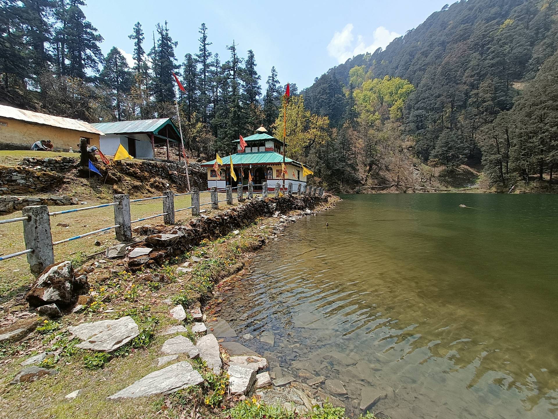
The lake holds deep mythological significance: it is widely believed to be the birthplace of Lord Ganesha, making it a site of quiet pilgrimage as much as a trekking destination. Its crystal-clear waters are home to the rare golden mahseer, a protected freshwater fish species that thrives in Dodital's undisturbed ecosystem. For nature lovers, moderate trekkers, and those seeking a Himalayan experience without the tourist crowds, the Dodital Trek delivers on every count.
In a state overflowing with celebrated trails, Dodital punches well above its weight. Here is why it deserves a spot on your 2026 trekking calendar:
- Pristine high-altitude lake: At 3,307m, Dodital Lake is one of the most accessible high-altitude lakes in Garhwal, yet remains remarkably unspoiled.
- Low crowd density: Compared to routes like Kedarkantha or Dayara Bugyal, Dodital sees a fraction of the footfall — ideal for trekkers who value silence and nature.
- Dense mixed forests: The trail winds through lush oak, rhododendron (spectacular in April–May bloom), and towering deodar stands along the Assi Ganga River valley.
- Wildlife sightings: The forests shelter the Himalayan Monal (Uttarakhand's state bird), musk deer, langurs, and various high-altitude bird species.
- Spiritual resonance: The sacred lake and its small Ganesha temple create a meditative atmosphere unlike purely recreational treks.
- Gateway to longer routes: Dodital connects to Darwa Top (4,110m) and the remote Agoda Lake, making it an ideal base for trekkers wanting to extend their adventure.
For a broader perspective on the region's options, browse our best treks in Uttarakhand guide.
At a glance
The route at a glance
The standard Dodital Trek route runs from Sangamchatti (the trailhead) to Dodital Lake, covering approximately 22 km one way (44 km return). The trail follows the Assi Ganga valley, climbing steadily through multiple forest zones before emerging at the lake.
Elevation profile:
- Sangamchatti: ~1,680m
- Agora Village: ~2,200m
- Bebra: ~2,500m (small rest point, tea available seasonally)
- Manjhi: ~2,700m
- Dodital Lake: 3,307m
- Darwa Top (optional): 4,110m
The dodital trek altitude gain from trailhead to lake is approximately 1,627m — moderate by Himalayan standards. Trail character includes well-defined forest paths, gentle river crossings over wooden bridges (exercise caution during monsoon), and rocky sections as you approach Manjhi and beyond. There is no technical climbing involved.
For trekkers interested in the optional extension, the Darwa Top Trek guide provides further detail on that high-altitude ridge.
How to Reach Sangamchatti (Dodital Trek Base) from Dehradun
The dodital trek from Dehradun logistics are straightforward. Dehradun serves as the primary gateway:
- Dehradun to Uttarkashi: ~160 km via Rishikesh–Chamba–Uttarkashi highway. Road journey takes approximately 5–6 hours by bus or shared taxi. Regular GMOU/GMVN buses depart from Dehradun's Mussoorie Bus Stand. Private taxis cost approximately ₹2,500–₹3,500 for the vehicle.
- Uttarkashi to Sangamchatti: ~20 km, approximately 45–60 minutes by local taxi or shared jeep. Sangamchatti sits at the confluence of the Assi Ganga and Bhagirathi rivers.
- Nearest railhead: Dehradun (Uttarakhand Express, Shatabdi from Delhi). Rishikesh is also usable but adds ~30 minutes.
- Nearest airport: Jolly Grant Airport, Dehradun (~25 km from city centre).
Overnight stay in Uttarkashi: Recommended before the trek begins. Several budget guesthouses and mid-range hotels are available near the main bazaar. GMVN's Tourist Rest House is a reliable option. See our Dehradun to Uttarkashi travel guide for detailed transport options.
Dodital Trek Elevation Table: Key Waypoints and Distances
| Waypoint | Altitude | Cumulative Distance (from Sangamchatti) |
|---|---|---|
| Sangamchatti (Start) | 1,680m | 0 km |
| Agora Village | ~2,200m | ~9 km |
| Bebra | ~2,500m | ~13 km |
| Manjhi | ~2,700m | ~17 km |
| Dodital Lake | 3,307m | ~22 km |
| Darwa Top (optional) | 4,110m | ~27 km |
Note: Distances are approximate and may vary slightly by source. Flag for field verification.
What each day actually looks like
The recommended format is a 4-night / 5-day schedule, though fit trekkers sometimes compress Day 2–3 into two shorter days.
Day 1 — Dehradun to Uttarkashi (Drive)
Distance: ~160 km | Duration: 5–6 hours driving
Depart Dehradun early (by 7:00 AM) to reach Uttarkashi by early afternoon. The drive follows the scenic Bhagirathi valley, passing through Chamba and Bhatwari. Use the afternoon to rest, acclimatise to Uttarkashi's altitude (~1,158m), sort permits, and stock up on supplies (dry fruits, energy bars, any medication). Overnight at Uttarkashi guesthouse.
Day 2 — Sangamchatti to Agora Village (Trek)
Distance: ~9 km | Altitude gain: ~520m (1,680m → 2,200m) | Walking time: 4–5 hours
Drive from Uttarkashi to Sangamchatti (~1 hour), collect your Forest Department permit at the checkpost, and begin the trek. The trail follows the Assi Ganga upstream through broadleaf forests. The path is relatively gentle on Day 2, making it ideal for settling into the rhythm. Agora village has basic guesthouses and a forest rest house. Camping is also possible in designated areas. Overnight at Agora.
Day 3 — Agora to Dodital via Manjhi (Trek)
Distance: ~13 km | Altitude gain: ~1,107m (2,200m → 3,307m) | Walking time: 6–8 hours
This is the most demanding day. The trail climbs through Bebra to Manjhi (~2,700m), where basic tea and snacks are sometimes available from seasonal dhabas. Beyond Manjhi, the trail steepens through rhododendron and birch forest before opening to the lake basin. Arrive at Dodital by early afternoon. Explore the Ganesha temple, observe the golden mahseer in the lake, and settle into camp. Forest Department campsites and a basic rest house are available at Dodital. Overnight at Dodital.
Day 4 — Dodital Exploration or Optional Darwa Top Hike
Distance: 0 km (rest) or ~10 km return to Darwa Top | Altitude: 3,307m–4,110m | Walking time: 5–6 hours return
Day 4 serves as an acclimatisation and exploration day. Option A (Rest day): Spend the morning by the lake, visit the Ganesha temple, birdwatch for Himalayan Monal, and take short walks around the lake basin. Option B (Darwa Top): Trek ~5 km to Darwa Top (4,110m) for panoramic views of Bandarpunch (6,316m) and Kalanag (6,387m) peaks. This is a non-technical high-altitude walk but requires good weather and an early start (by 6:00 AM). Return to Dodital campsite by early afternoon. Overnight at Dodital.
Day 5 — Dodital to Sangamchatti: Descent and Drive Back
Distance: ~22 km descent | Duration: 6–7 hours walking, then 1 hr drive to Uttarkashi
Begin the descent early to avoid afternoon fatigue. The return follows the same route. Many trekkers reach Sangamchatti by 2:00–3:00 PM and drive to Uttarkashi or continue onward to Dehradun (arriving late evening). Note: If pushing directly to Dehradun on Day 5, ensure you depart Sangamchatti by 2:00 PM at the latest.
Optional Extension: Darwa Top and Agoda Lake
If Day 4's Darwa Top hike (detailed above) has whetted your appetite, Agoda Lake represents a further extension for experienced trekkers willing to add 1–2 additional days. Agoda is a remote alpine lake beyond Darwa Top, at approximately 3,600–3,800m (exact altitude flagged for verification). Trails beyond Darwa Top are less marked and a local guide is strongly recommended. This extension is best suited to trekkers with prior high-altitude experience.
When to go
The dodital trek best time to visit depends on your priorities:
Spring / Early Summer (April – June) — Prime Season
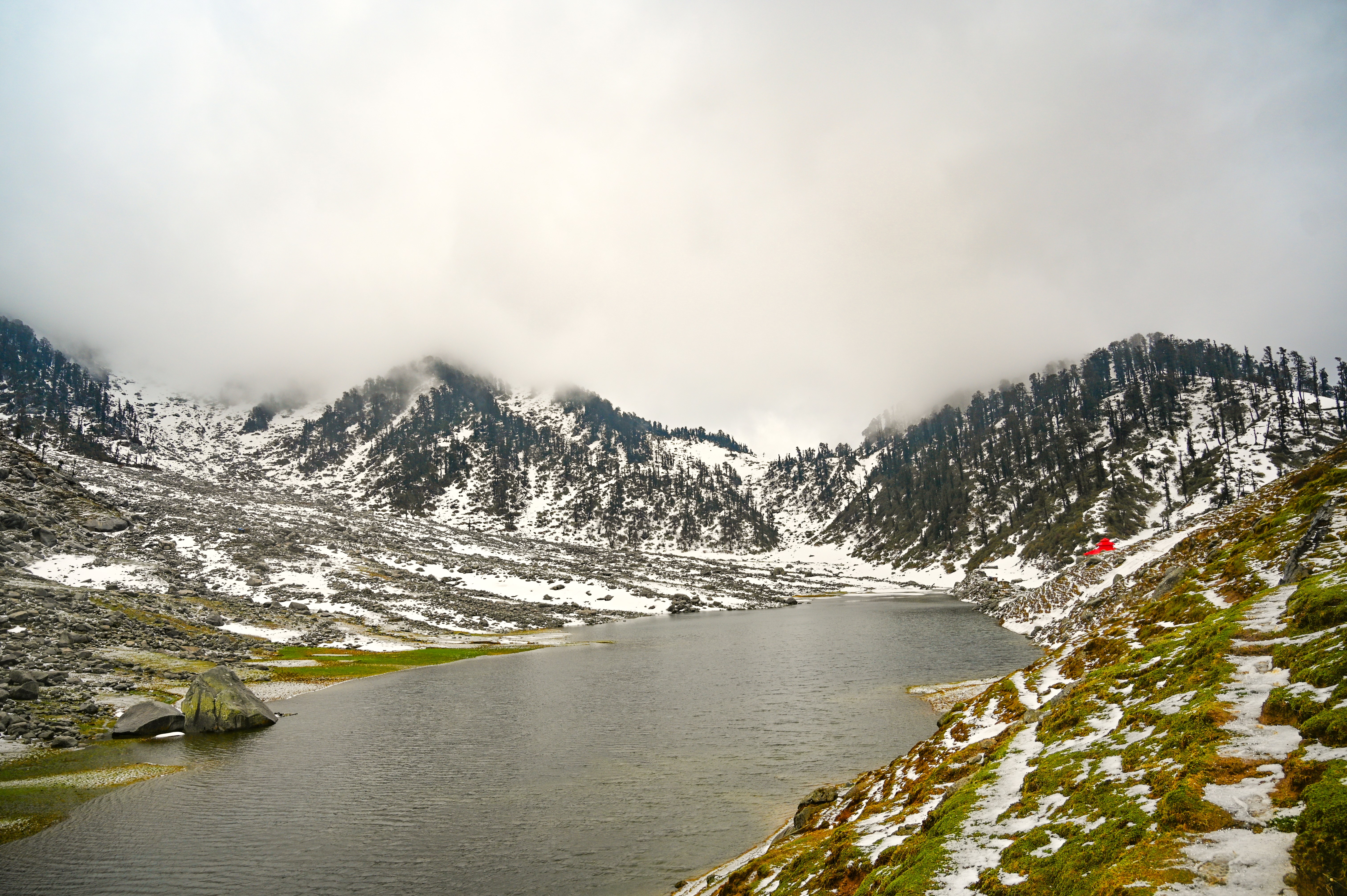
This is the most popular window. Rhododendrons paint the forest crimson and pink (peak bloom: mid-April to mid-May). Temperatures at the lake range from 5°C to 18°C during the day. Snow may linger on higher sections in April but is generally passable. Skies are mostly clear and wildlife is active.
Monsoon (July – September) — Not Recommended
Heavy rainfall makes trails slippery and risky. Leeches are prevalent below 2,500m. Landslide risk on the Uttarkashi highway is significant. Visibility is poor and river crossings become dangerous. Avoid unless you have extensive monsoon trekking experience.
Autumn (October – November) — Prime Season
Post-monsoon skies are crystal clear, offering excellent mountain views from Darwa Top. Forests turn golden and amber. Temperatures drop (nights at Dodital can reach -5°C to -8°C), so carry a warm sleeping bag. This is arguably the best season for photography.
Winter (December – March) — Expert Only
The route receives heavy snowfall and is effectively closed to casual trekkers. Experienced mountaineers with appropriate winter gear (snowshoes, crampons, avalanche awareness) can attempt it, but permits and local guidance are essential. Not recommended for general trekkers.
Is this trek right for you?
Difficulty Rating: Moderate
The dodital trek difficulty sits firmly in the moderate category. Here is the breakdown:
- Maximum altitude: 3,307m at Dodital Lake; 4,110m at Darwa Top (optional)
- Maximum daily ascent: ~1,100m (Day 3)
- Maximum daily distance: ~13 km (Day 3)
- Technical terrain: None — no ropes, fixed lines, or glacier crossings required
- Trail condition: Well-defined for most sections; some rocky patches near Manjhi and above
Fitness advice: Begin cardiovascular training (jogging, cycling, stair climbing) 4–6 weeks before the trek. No prior high-altitude experience is mandatory, though it is beneficial. The trek is suitable for fit beginners and intermediate trekkers aged approximately 12–60. Children below 12 and seniors above 60 should consult a physician and consider the shorter Agora-only itinerary.
For detailed guidance on altitude management, read our altitude sickness prevention guide.
What permits you need
A Forest Department entry permit is mandatory for the Dodital Trek.
- Where to obtain: At the Uttarkashi Forest Department checkpost at Sangamchatti. No advance online booking is available as of the 2026 season — permits are issued at the entry point.
- Cost: Approximately ₹150–₹200 per person per day.
- Camping fees: Additional camping fees may apply at GMVN / forest department campsites at Agora and Dodital. Estimate ₹100–₹200 per tent per night.
- Documents required: Government-issued photo ID (Aadhaar, passport, or driver's licence). Carry originals and photocopies.
- Guides: Hiring a guide registered with the Uttarkashi District Tourism Office is strongly recommended and may be required for groups. Confirm current regulations at the checkpost.
- Foreign nationals: Foreign trekkers should carry their passport and Indian visa copies. Additional registration may be required at Uttarkashi's Forest Department office.
For a comprehensive overview of permit rules across Uttarakhand, see our Uttarakhand trek permits guide.
What this trek will cost you
DIY Trek Budget (Per Person)
| Expense | Estimated Cost (INR) |
|---|---|
| Transport: Dehradun → Uttarkashi → Sangamchatti (shared) | ₹600–₹1,200 |
| Forest Department permits (3 days) | ₹300–₹600 |
| Accommodation / camping (4 nights) | ₹300–₹600 per night |
| Meals on trail (4 days) | ₹200–₹400 per day |
| Guide / porter (optional, per day) | ₹800–₹1,200 per day |
| Miscellaneous (water, snacks, porter tip) | ₹500–₹1,000 |
| Total DIY Estimate | ₹4,000–₹8,000 |
All costs are estimates for 2026. Prices may vary seasonally and with operator. Flag for verification.
Organised Package (4N/5D from Dehradun)
Estimated range: ₹7,000–₹15,000 per person
Typically included: Transport from Dehradun, all permits, guide, camping equipment, meals during trek, basic first-aid.
Typically excluded: Personal trekking gear, travel insurance, meals in Dehradun/Uttarkashi, porter charges beyond included porter-to-trekker ratio, tips.
Package rates vary significantly by operator quality. Always verify inclusions in writing before booking.
What to pack
Use this dodital trek packing list as your baseline. Adjust for season.
Clothing (Layering System)
- Moisture-wicking thermal base layer (top and bottom)
- Insulating mid-layer (fleece or down jacket)
- Waterproof and windproof outer shell / rain jacket
- Trekking pants (convertible zip-off recommended)
- Warm hat / balaclava and sun hat
- Fleece-lined gloves
- 3–4 pairs moisture-wicking trekking socks
Footwear
- Ankle-support waterproof trekking boots (broken in before trek)
- Camp sandals / lightweight shoes
- Gaiters (essential for monsoon season, useful in April snow)
Backpack and Carry
- 40–50L trekking backpack with rain cover
- Dry bags / stuff sacks for electronics and documents
Camping and Sleep
- Sleeping bag rated to -5°C (minimum; -10°C recommended for October–November)
- Trekking poles (collapsible, highly recommended for knee protection on descent)
- Head torch / headlamp with spare batteries
Essentials
- High-SPF sunscreen (SPF 50+)
- UV-protection sunglasses
- Water bottles (2 × 1L minimum) + water purification tablets or filter
- Energy bars, trail mix, electrolyte sachets
- Offline maps downloaded (Maps.me or Gaia GPS — no signal on trail)
Medical Kit
- AMS medication: Diamox (Acetazolamide) — consult doctor before use
- Paracetamol / ibuprofen
- Blister care (moleskin, antiseptic, bandages)
- Antihistamine (for insect bites and allergic reactions)
- ORS sachets
- Personal prescription medications
Documents
- Original government ID + 2 photocopies
- Permit copies
- Emergency contact card (written, not only digital)
- Travel insurance documents
For a deeper gear breakdown, see our trekking packing list for India.
Recommended gear for this trek
Staying safe on the mountain
Acute Mountain Sickness (AMS)
AMS symptoms (headache, nausea, dizziness) can appear above 2,500m. Plan a rest / acclimatisation day at Dodital (Day 4) rather than pushing immediately to Darwa Top. If symptoms worsen, descend immediately — do not sleep at altitude with AMS symptoms. Carry Diamox only after medical consultation. Read our full altitude sickness prevention guide.
Weather Changes
Weather above 3,000m can shift rapidly. Always carry your rain jacket, even on clear mornings. Check forecasts in Uttarkashi before departing for the trail.
River Crossing Safety
The Assi Ganga crossings use wooden bridges in most sections. During monsoon (not recommended season), water levels can make crossings hazardous. Never attempt a flooded crossing.
Mobile Network
BSNL has partial coverage near Uttarkashi town. There is no reliable mobile signal on the trail from Sangamchatti onwards. Download offline maps before leaving Uttarkashi. Share your itinerary with a trusted contact and inform your guesthouse of your plan and expected return.
Emergency Contacts
- Uttarkashi SDRF (State Disaster Response Force): 01374-222351
- Uttarkashi District Hospital: Available in Uttarkashi town
- Local guide association: Inquire at Uttarkashi District Tourism Office on arrival
Never Trek Alone
Always trek with at least one partner or hire a registered local guide. Inform the Sangamchatti checkpost of your planned itinerary and expected return date.
Wildlife Safety
Do not feed any animals. Maintain distance from musk deer habitats, especially in the forest zones near Manjhi. Keep food stored securely at camp to avoid attracting wildlife.
Similar treks to explore
Kareri Lake Trek: Complete Guide for 2026
Plan your Kareri Lake trek with our 2026 guide covering route, difficulty, permits, cost, packing list, best time to visit, and day-wise itinerary.
Buran Ghati Trek: Complete Guide 2026
The Buran Ghati Trek is a difficult 40 km trail in Himachal Pradesh crossing a 4,700 m pass with India's only glacier rappel descent on a mainstream trek.
Indrahar Pass Trek: Routes, Difficulty & Best Time
Indrahar Pass trek is a moderate-to-difficult 4-day route in the Dhauladhar range, starting from McLeod Ganj and reaching 4,342 m (14,245 ft). Best done September–October.
Common questions answered
The one-way dodital trek distance from Sangamchatti to Dodital Lake is approximately 22 km, making the return journey roughly 44 km in total. The lake sits at 3,307m above sea level. The optional high point is Darwa Top at 4,110m, approximately 5 km beyond the lake. (Distances flagged for verification — minor variations exist between sources.)