Why Gaumukh Tapovan Trek is on every trekker's list
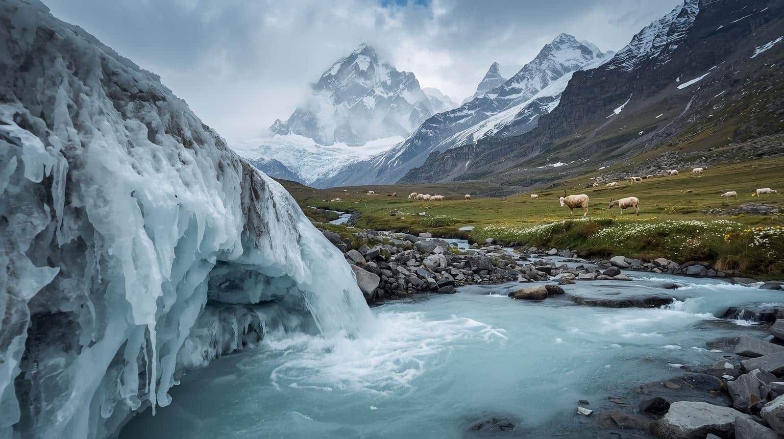
Few treks in India carry the combined weight of spiritual gravity and raw alpine grandeur that the Gaumukh Tapovan Trek does. Beginning at Gangotri (3,048 m), one of the four sacred Char Dham pilgrimage sites in Uttarakhand, the route follows the Bhagirathi River upstream through silver birch forests and boulder-strewn moraines to Gaumukh — the glacier snout that is venerated as the source of the River Ganga. From there, a steep, demanding ascent leads to Tapovan (4,463 m), a vast alpine meadow that sits in the shadow of the breathtaking Shivling peak (6,543 m).
The trek covers approximately 46 km round trip and is graded Moderate to Difficult. What sets it apart from most Himalayan routes is the rare fusion it offers: a living pilgrimage trail shared by sadhus and mountaineers alike, a glacier to cross, sky-piercing peaks on every horizon, and a solitude beyond Gaumukh that feels genuinely earned. In the 2026 trekking season, with growing interest in lesser-crowded high-altitude routes, Gaumukh Tapovan remains an essential experience for serious trekkers.
The reasons to choose this trek over hundreds of others in the Himalayas are both practical and profound.
Spiritual significance is woven into every kilometre. Gaumukh — literally cow's mouth in Sanskrit — is the glacial snout of the Gangotri Glacier, and Hindus believe the sacred Ganga originates here. Thousands of pilgrims make the journey to Gaumukh annually, giving the trail a unique energy unlike purely recreational trekking routes.
Peak panoramas at Tapovan are among the finest accessible without technical climbing. Standing on the meadow, you face the soaring granite spire of Shivling (6,543 m), the three-summited Bhagirathi massif (Bhagirathi I: 6,856 m, Bhagirathi II: 6,512 m, Bhagirathi III: 6,454 m), and the legendary Meru Peak (6,660 m) — the same wall that inspired some of the world's most celebrated mountaineering expeditions. [Note: Peak elevations flagged for verification — see fact-check log.]
Wilderness depth is another draw. The trail from Gangotri to Gaumukh is well-trodden, but beyond the glacier snout, crowds thin dramatically. Tapovan is used by mountaineering expeditions as a base camp, meaning the meadow sees serious climbers and committed trekkers — not day-trippers.
Adventure variety is exceptional. In a single itinerary you walk through dense Himalayan forest, traverse open moraine, cross an active glacier, scramble up loose scree, and arrive at a flowering meadow at over 4,400 m. Few treks in India pack this much terrain variety into six days.
For internal context, if you are considering shorter alternatives, see our guides to the Gangotri to Gaumukh Trek and Har Ki Dun Trek.
At a glance
The route at a glance
The route follows a single corridor: Gangotri → Chirbasa → Bhojbasa → Gaumukh Glacier → Tapovan, then retraces the same path on the return.
| Segment | Distance | Elevation |
|---|---|---|
| Gangotri | — | 3,048 m |
| Chirbasa | ~9 km from Gangotri | 3,600 m |
| Bhojbasa | ~14 km from Gangotri | 3,792 m |
| Gaumukh Glacier | ~18 km from Gangotri | 3,892 m |
| Tapovan | ~21 km from Gangotri | 4,463 m |
Total round trip: approximately 46 km. A printed route map is available at the Forest Department check post in Gangotri town; offline maps (Maps.me or Gaia GPS) should be downloaded before departure.
Gangotri to Chirbasa
Distance: ~9 km. This is the most forgiving section of the trek — a gradual, well-marked ascent through fragrant deodar and bhoj (silver birch) forest along the left bank of the Bhagirathi River. The trail is clear, signposted, and shared by pilgrims and trekkers. Elevation gain is approximately 550 m over 9 km, making it a comfortable warm-up day. Chirbasa has basic camping options and is used as a rest point rather than a serious overnight stop by most groups.
Chirbasa to Bhojbasa
Distance: ~5 km. The treeline ends abruptly here and the landscape shifts to open moraine — grey, rocky, and windswept. This transition marks your entry into the high-altitude zone. The first dramatic views of the Bhagirathi peaks appear to the north. Bhojbasa (3,792 m) has a GMVN (Garhwal Mandal Vikas Nigam) rest house where most trekkers overnight, a small dhaba, and tent camping space. Booking the GMVN hut in advance is strongly recommended during the May–June and September–October peak seasons.
Bhojbasa to Gaumukh Glacier
Distance: ~4 km. A rocky, undulating moraine path leads to the glacier snout. The scale of the Gangotri Glacier — one of the largest in the Himalayas — becomes apparent as you approach. The Gaumukh snout itself is a dramatic, ever-shifting ice wall from which the icy Bhagirathi River emerges. This is a sacred site; many pilgrims take a ceremonial dip in the freezing water. Photography opportunities are extraordinary. Note that the glacier is actively retreating, so conditions at the snout change year to year. [See also: Gangotri Travel Guide]
Gaumukh to Tapovan
Distance: ~3 km. This is the crux of the trek. After reaching Gaumukh, you must cross the glacier — a section that can require microspike crampons depending on conditions at the time of your visit. The crossing is followed by a brutally steep 600 m ascent on loose scree and snow slopes. The gradient and altitude combine to make this the most physically and mentally demanding section. However, once you crest the ridge and the Tapovan meadow opens before you — wide, green in season, and dominated by the vertical granite face of Shivling — the effort is entirely vindicated. There are no permanent structures at Tapovan; camping is the only option.
What each day actually looks like
This is the standard 6-day itinerary for the Gaumukh Tapovan Trek from Rishikesh or Haridwar.
Day 1 — Drive: Haridwar/Rishikesh to Gangotri
Approx. 250 km, 9–10 hours by road. The drive passes through Uttarkashi and the scenic Bhagirathi Valley. Arrive at Gangotri, check in, visit the Gangotri Temple, and acclimatise at 3,048 m. Rest is mandatory — avoid strenuous activity. Altitude gain: arrival at 3,048 m.
Day 2 — Gangotri to Bhojbasa (14 km, 5–6 hrs)
Early morning start after temple visit. Trek through Chirbasa (rest/snack stop) to Bhojbasa. Altitude gain: ~744 m. Stay at GMVN rest house or tented camp at Bhojbasa (3,792 m). Hydrate well and eat a warm dinner. This day's steady ascent is excellent for acclimatisation.
Day 3 — Bhojbasa to Gaumukh to Tapovan (7 km, 5–6 hrs)
Start by 6:00–7:00 am. Reach Gaumukh glacier snout (~4 km, 1.5 hrs), spend time at the sacred source, then tackle the glacier crossing and steep 600 m scree ascent to Tapovan (4,463 m). Altitude gain: ~671 m from Bhojbasa. Set up tents on the meadow. This is the most strenuous day — pack light and carry crampons/microspikes.
Day 4 — Acclimatisation and Exploration at Tapovan
A full rest and exploration day at Tapovan. This is arguably the most rewarding day of the trek. Options include hiking to the base of Shivling for closer views, exploring the upper meadow, watching mountaineering expeditions, or simply resting and absorbing the panorama of Shivling, Bhagirathi I/II/III, and Meru. No altitude gain required. Hydrate, eat well, and photograph extensively.
Day 5 — Tapovan to Gangotri (21 km, 7–8 hrs)
Long descent day. Retrace the route: Tapovan → Gaumukh (glacier crossing) → Bhojbasa (brief stop) → Chirbasa → Gangotri. Start no later than 6:00 am. Descent is hard on knees — use trekking poles. Arrive Gangotri by afternoon, hot meal and rest.
Day 6 — Drive Back to Rishikesh/Haridwar or Buffer Day
Departure drive to Rishikesh (~9–10 hrs) or use as a buffer day if Day 5 weather caused delays. A buffer day is recommended for trekkers with onward flight connections.
When to go
May–June (Peak Season — Best Weather)
The Gangotri Temple opens on Akshaya Tritiya (date varies in May each year), which also marks the official opening of the trekking season. Snowfields from winter begin to consolidate, skies are largely clear, and temperatures at Tapovan range from -5°C to 10°C. This is the busiest period — expect company on the trail but reliable conditions.
July–August (Monsoon — Avoid)
The Uttarakhand monsoon brings heavy rainfall, swollen river crossings, rockfall risk on moraine sections, and poor visibility. The Gangotri–Gaumukh trail becomes genuinely hazardous. Most experienced operators suspend departures. This window is strongly recommended to avoid.
September–October (Post-Monsoon — Ideal for Solitude)
Post-monsoon skies are crystalline, the meadows at Tapovan are at their greenest, and crowds thin considerably compared to May–June. Temperatures drop faster as October progresses, with sub-zero nights at Tapovan by mid-October. This is the preferred window for experienced trekkers. The Gangotri Temple closes around Diwali (October/November), after which the road and trail are progressively blocked by snow.
November–April (Closed)
Heavy snowfall makes the route impassable and genuinely dangerous. The region is inaccessible for most of this period. Do not attempt the trek outside the May–June or September–October windows.
[For more Uttarakhand trekking season planning, see our Uttarakhand Trek Permits Guide.]
Is this trek right for you?
Grade: Moderate to Difficult
The Gangotri-to-Gaumukh section alone (without Tapovan) is moderate — suitable for reasonably fit individuals with some trekking experience. The Gaumukh-to-Tapovan extension elevates the grade to difficult due to:
- Glacier crossing with crevasse risk and slippery ice
- 600 m ascent on loose scree and snow in a short 3 km stretch
- Maximum altitude of 4,463 m with genuine AMS risk
- Variable weather — afternoon thunderstorms can develop quickly above 4,000 m
Fitness Benchmarks: You should be comfortable walking 15–20 km per day with a 10–12 kg pack. Before the trek, a structured 8–12 week preparation programme is recommended:
- Cardio: Running 5–8 km daily, cycling, swimming
- Strength: Stair climbing with a loaded pack (best simulation for moraine terrain)
- Flexibility: Yoga and stretching to aid breathing at altitude
Altitude Mountain Sickness (AMS): Symptoms include headache, nausea, dizziness, and fatigue. If symptoms appear above Bhojbasa, rest and hydrate. If symptoms worsen — especially signs of HACE (High Altitude Cerebral Edema: confusion, loss of coordination) or HAPE (High Altitude Pulmonary Edema: breathlessness at rest, cough) — descend immediately and seek medical attention. Acclimatisation nights at Gangotri (Day 1) and Bhojbasa (Day 2) are built into the itinerary for this reason. [See our detailed Altitude Sickness Prevention Guide.]
Not suitable for: Complete beginners with zero trekking experience, those with cardiac or chronic respiratory conditions, or anyone who has experienced severe AMS previously without medical clearance.
What permits you need
Two permits are mandatory for the Gaumukh Tapovan Trek. Neither is available online as of 2026 — both must be obtained in person.
1. Gangotri National Park Entry Permit
- Indian nationals: INR 150 per person per day
- Foreign nationals: INR 600 per person per day
- Where: Forest Department check post at Gangotri town (located near the temple complex entrance)
- Documents required: Government-issued photo ID (Aadhaar, passport), 2–4 passport-size photographs
[Note: Permit fees flagged for 2026 verification — rates may have been revised by the Uttarakhand Forest Department. Confirm at the check post on arrival.]
2. Special Permission for Tapovan (Inner Line / Restricted Zone Permit)
- Required for trekking beyond Gaumukh to Tapovan
- Obtain via: DFO (District Forest Officer) Uttarkashi office, or coordinate through a registered trekking operator (operators handle this paperwork as part of organised packages)
- Documents required: Government ID, passport-size photos, sometimes a medical fitness declaration
- Address: DFO Uttarkashi, Forest Division Office, Uttarkashi town
GMVN Registration: If you plan to stay at the GMVN rest house at Bhojbasa, book and register in advance through GMVN Uttarkashi (contact: 01374-222-228).
Carry 4–6 passport-size photographs and photocopies of your ID throughout the trek — checkpoints may request them at multiple points. [For a full breakdown of permit procedures across Uttarakhand, see our Uttarakhand Trek Permits Guide.]
What this trek will cost you
Below is a realistic 2026 cost breakdown for a 6-day Gaumukh Tapovan Trek.
DIY Cost Breakdown (Per Person)
| Item | Estimated Cost (INR) |
|---|---|
| Transport: Rishikesh–Gangotri–Rishikesh (shared taxi) | 1,500–2,000 |
| National Park entry permit (6 days, Indian national) | 900 |
| Tapovan special permission | ~200–500 |
| GMVN Bhojbasa accommodation (1–2 nights) | 500–1,600 |
| Camping gear rental (tent, sleeping bag, mat) | 500–1,000/day |
| Food on trail (dhabas + self-cooked at Tapovan) | 300–500/day |
| Guide (Gaumukh–Tapovan section recommended) | 800–1,200/day |
| Porter (optional) | 800–1,200/day |
| Estimated DIY Total (6 days) | INR 8,000–14,000 |
Organised Package (Per Person)
Reputed operators such as Indiahikes and Trek The Himalayas offer all-inclusive packages covering transport from Rishikesh, permits, accommodation, meals, guides, and safety equipment.
| Package Type | Cost Range (INR) |
|---|---|
| Budget operator (group of 10+) | 12,000–15,000 |
| Premium operator (small group, quality gear) | 16,000–22,000 |
[Note: Operator prices are estimates based on 2025 season data; confirm 2026 pricing directly with operators. Flagged for review.]
DIY vs. Package — Quick Comparison
| Factor | DIY | Organised Package |
|---|---|---|
| Cost | Lower (INR 8k–14k) | Higher (INR 12k–22k) |
| Flexibility | High | Fixed itinerary |
| Permit handling | Self-managed | Operator handles |
| Safety support | Limited | Guide + first aid |
| Best for | Experienced trekkers | First-timers to route |
[For gear rental and purchase advice, see our Best Trekking Gear India guide.]
What to pack
Keep your pack under 12 kg (excluding water). A porter can carry an additional bag if needed.
Clothing & Layering
Layering is non-negotiable for Tapovan, where nights can drop to -10°C or below even in September. Use the three-layer system:
- Base layer: Moisture-wicking thermal top and bottom (merino wool or synthetic) — 2 sets
- Mid layer: Fleece jacket or down vest for insulation
- Outer shell: Hardshell waterproof/windproof jacket and waterproof trousers
- Trekking trousers: 2 pairs (one convertible)
- Footwear: Waterproof ankle-support trekking boots (broken in before the trek), camp sandals/shoes
- Extremities: Woollen/synthetic beanie, balaclava, liner gloves + waterproof over-gloves, neck gaiter, sun hat with brim
- Gaiters: Essential for moraine and snow sections above Gaumukh
- Socks: 4–5 pairs merino wool; change daily to prevent blisters
Camping & Shelter Gear
No permanent structures exist at Tapovan — a tent is mandatory for all nights there.
- Tent: 3-season, wind-rated to 50 kph minimum; freestanding preferred for rocky ground
- Sleeping bag: Rated to -10°C (comfort rating) — do not compromise on this for Tapovan nights
- Sleeping mat: Insulated foam or inflatable with R-value 4+
- Trekking poles: Adjustable, with spare tips
- Crampon microspikes: For glacier crossing at Gaumukh
- Headlamp: 200+ lumens with spare batteries
[See our curated Best Sleeping Bags for High Altitude India guide for 2026 recommendations.]
Safety & Medical Kit
- Diamox (Acetazolamide): Consult your doctor before use; standard prophylactic dose is 125–250 mg twice daily starting 24 hrs before ascent — do not self-prescribe
- Blister kit: Moleskin, antiseptic wipes, sterile dressings
- ORS sachets: Rehydration salts for hot and cold drinks
- Pain relief: Ibuprofen/paracetamol
- Altitude emergency: Dexamethasone (carry, do not use without medical direction)
- Emergency whistle and signal mirror
- Satellite communicator (e.g., Garmin inReach): Strongly recommended above Gaumukh where mobile signal is absent
- Water purification: Iodine tabs + portable filter; never drink unfiltered glacier meltwater
- Sunscreen: SPF 50+ (UV intensity at 4,000+ m is severe); lip balm SPF 30+
- Documents: Original ID, permit photocopies, emergency contact card, travel insurance details
- Electronics: Power bank (20,000 mAh minimum; cold kills battery faster), offline maps downloaded (Gaia GPS or Maps.me)
Recommended gear for this trek
Staying safe on the mountain
Altitude Sickness (AMS/HACE/HAPE)
The single greatest risk on this trek. Ascend gradually, follow the itinerary without rushing, and hydrate with 3–4 litres of water daily. Learn to distinguish AMS (manageable, rest and monitor) from HACE/HAPE (life-threatening, descend immediately). If a trekker becomes confused, loses coordination, or has persistent breathlessness at rest — do not wait for morning. Descend at once and call for help. [Full protocol: see our Altitude Sickness Prevention Guide.]
Glacier Crossing Safety
Never cross the glacier section alone. Use trekking poles for balance. Follow your guide's line — experienced local guides know the stable crossing points that shift with seasonal ice movement. Watch for crevasses, especially in warmer afternoon conditions. Wear microspike crampons.
Weather Windows
Start every trekking day by 6:00–7:00 am. High-altitude thunderstorms typically build in the afternoon. If you see anvil clouds developing over the peaks, find shelter immediately. Do not push on in deteriorating weather above Gaumukh.
Emergency Contacts (2026)
- Uttarkashi District Emergency: 01374-222-350
- GMVN Uttarkashi: 01374-222-228
- Nearest hospital: District Hospital Uttarkashi
[Note: Emergency numbers flagged for verification — confirm current numbers with local authorities before departure.]
Guide Requirement
Hire a registered local guide for the Gaumukh to Tapovan section at minimum. Route-finding on the glacier and scree above Gaumukh is non-trivial, and guides carry emergency equipment.
Register Your Trek
Leave your itinerary, emergency contact, and expected return date with the Forest Department check post at Gangotri and with your accommodation in Gangotri town.
Leave No Trace
Gangotri National Park is an ecologically sensitive protected area. Pack out all non-biodegradable waste from Tapovan — there is no waste collection service above Bhojbasa. Use designated toilet spots, carry waste bags, and avoid disturbing wildlife.
Water Safety
Always purify glacier meltwater before drinking. Giardia and other pathogens are present despite the apparent purity of glacial streams.
[This trek is one of several outstanding routes in the region — see also: Kedarnath Trek Guide, Roopkund Trek Guide, and Uttarkashi Treks.]
Similar treks to explore
Kareri Lake Trek: Complete Guide for 2026
Plan your Kareri Lake trek with our 2026 guide covering route, difficulty, permits, cost, packing list, best time to visit, and day-wise itinerary.
Buran Ghati Trek: Complete Guide 2026
The Buran Ghati Trek is a difficult 40 km trail in Himachal Pradesh crossing a 4,700 m pass with India's only glacier rappel descent on a mainstream trek.
Indrahar Pass Trek: Routes, Difficulty & Best Time
Indrahar Pass trek is a moderate-to-difficult 4-day route in the Dhauladhar range, starting from McLeod Ganj and reaching 4,342 m (14,245 ft). Best done September–October.
Common questions answered
The trek is graded Moderate to Difficult. The Gangotri-to-Gaumukh section is moderate and manageable for fit individuals with basic trekking experience. The Tapovan extension adds significant difficulty: a glacier crossing that may require microspike crampons, a sharp 600 m ascent on loose scree and snow in just 3 km, and a maximum altitude of 4,463 m where altitude mountain sickness is a genuine risk. Previous experience on multi-day high-altitude treks (ideally above 3,500 m) is strongly recommended before attempting the full Gaumukh Tapovan route.