Why Har Ki Dun Trek is on every trekker's list
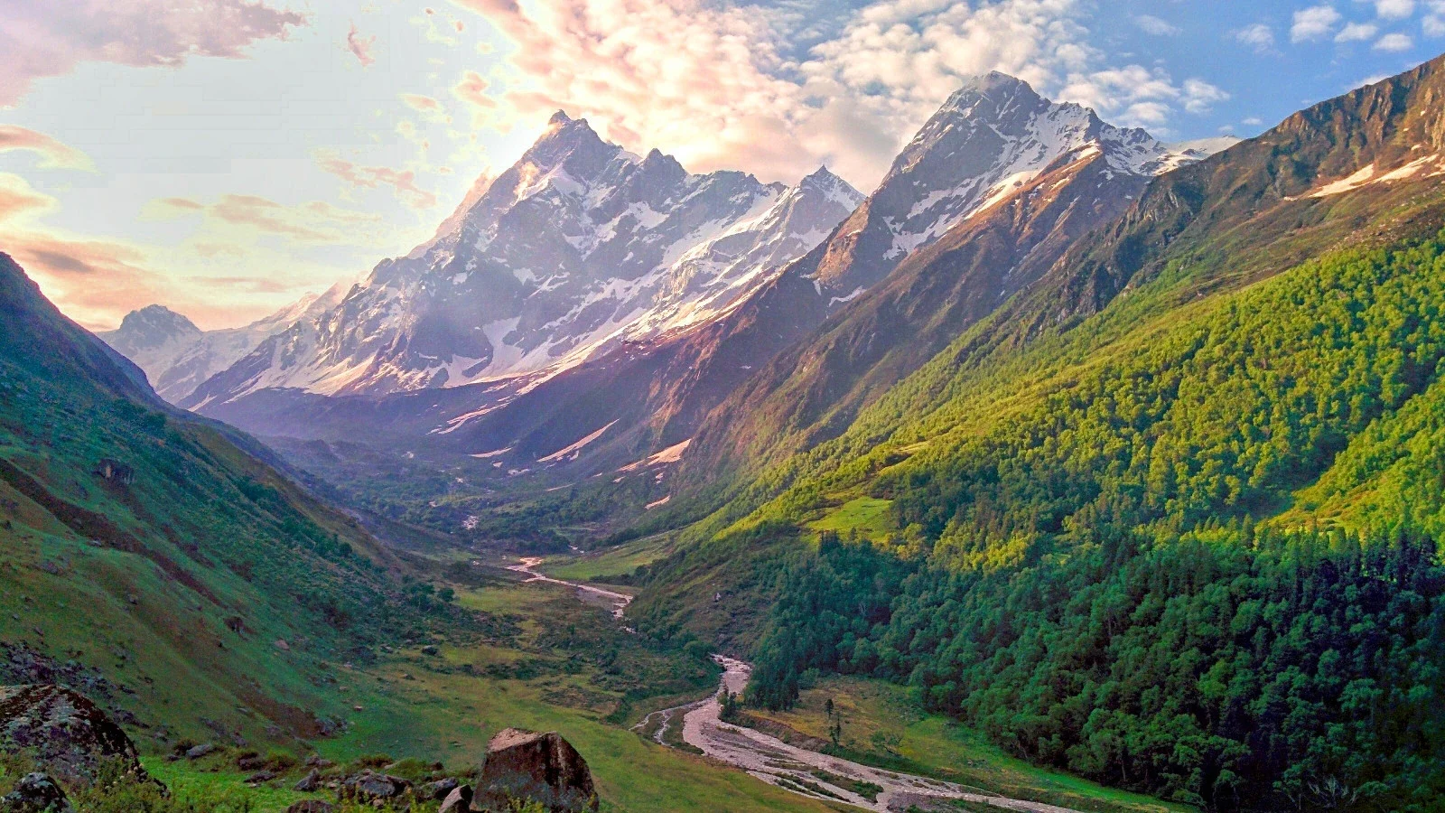
Tucked deep inside the Garhwal Himalayas, the Har Ki Dun valley sits at 3,566 m and carries a mythology older than most Himalayan trails. Local legend holds that the Pandavas chose this very valley as their final earthward path before ascending to heaven — earning the surrounding massif the name Swargarohini, literally "the stairway to heaven." Peer across the meadow on a clear October morning and the logic is hard to argue: a cathedral wall of snow peaks — Swargarohini (6,252 m), Bandarpunch (6,316 m), and Black Peak (6,387 m) — frames a broad glacial basin where the young Tons River gurgles its first notes.
Yet for all this drama, the Har Ki Dun trek remains one of Uttarakhand's most accessible multi-day routes. It demands no technical climbing, tops out below 3,600 m, and rewards beginners and seasoned trekkers alike. This guide covers everything you need for the 2026 trekking season: approach routes from Dehradun, a full day-wise itinerary, permit rules, costs, packing essentials, and safety advice.
In an era when Kedarkantha queues resemble Mumbai local trains in peak season, and the Valley of Flowers occasionally struggles with visitor pressure, Har Ki Dun offers something increasingly rare: genuine solitude without sacrificing scenery.
Mythological depth. Few Himalayan valleys carry as rich a narrative. Osla village still houses an ancient Duryodhana temple — yes, the Mahabharata villain is venerated here — and locals recount the Pandava ascent as lived history rather than legend.
Panoramic payoff. The amphitheatre of peaks visible from the valley head is arguably the finest sub-4,000 m viewpoint in Uttarakhand. Swargarohini's saw-toothed ridge, Bandarpunch's permanent ice cap, and Black Peak's dark pyramid create a panorama that rivals viewpoints twice as high.
Biodiversity. The trail passes through Govind Pashu Vihar National Park, a UNESCO-recognised biosphere reserve. Expect dense deodar and oak forests below, brilliant rhododendron blooms in spring, Himalayan monal pheasants flashing iridescent plumage, and, if you are fortunate, glimpses of snow leopard tracks in winter.
Beginner-friendly. Maximum altitude stays below 3,600 m, daily distances average 9–13 km, and the gradient is gentle enough for a fit first-timer. No ropes, no crampons in the standard season.
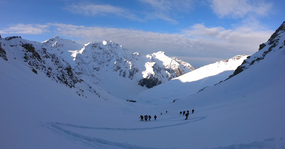
Winter option. From December to March the valley transforms into a snow-covered wilderness. For experienced trekkers comfortable with sub-zero camping, this is one of the best winter treks in India.
At a glance
The route at a glance
The standard round-trip trail runs approximately 47 km from Taluka (the official trek start point near Sankri) to the Har Ki Dun valley and back, with a total elevation gain of roughly 1,650 m.
| Point | Approximate Altitude |
|---|---|
| Sankri | 1,900 m |
| Taluka | 1,900 m |
| Osla | 2,560 m |
| Har Ki Dun Valley | 3,566 m |
Elevation profile: The trail climbs gradually from Taluka through the Tons river gorge, dense conifer forest, and scrub-covered slopes before opening into the broad sub-alpine meadows around Osla. The final section from Osla to the valley head crosses open terrain with alpine grassland and glacier-fed streams. There is no sudden altitude spike — the ascent is spread evenly across three walking days, which aids natural acclimatisation.
Terrain highlights: River crossings on log or suspension bridges over the Supin (a Tons tributary), boulder-hopped streams, rhododendron tunnels, and expansive bugyals (high-altitude meadows) characterise the route. Trail surface is mostly well-defined dirt path; some sections near Har Ki Dun can be boggy in monsoon or snowbound in winter.
Side trail — Jaundhar Glacier: A popular half-day detour from the valley camp leads north toward the Jaundhar Glacier snout. The trail is rough and unmarked in places; a local guide is recommended. The glacier is visibly receding — an important conservation reminder. [Exact distance to glacier snout: flagged for review — local guide confirmation advised.]
For those planning to extend their adventure, the trail onward from Har Ki Dun connects — for experienced mountaineers — to the Borasu Pass and the Kinnaur valley. This extension is beyond the scope of a beginner itinerary.
Har Ki Dun Trek from Dehradun
The journey from Dehradun to the trailhead at Sankri covers approximately 200 km by road and takes 8–9 hours depending on road conditions and seasonal traffic.
Route: Dehradun → Vikasnagar → Purola → Mori → Sankri
Transport options:
- Shared jeep: Daily departures from Dehradun's Parade Ground bus stand area (early morning, typically 05:00–06:00). Fare approximately ₹500–800 per seat. Book a day ahead in peak season.
- Private cab: ₹4,000–6,000 for the full vehicle one-way; more comfortable, allows overnight stops. [2026 rates: flagged for review — confirm with local operators.]
- GMOU/GMVN bus: Government buses operate on this corridor but are less frequent and slower. Check current schedules with GMVN Dehradun office before travelling.
- Overnight at Mussoorie: Some trekkers prefer to break the journey at Mussoorie (40 km from Dehradun), spending a night there before continuing to Sankri the following morning — a sensible option if arriving in Dehradun by afternoon or evening.
The road beyond Mori narrows considerably and passes through Govind Pashu Vihar buffer zone; mountain sickness (or carsickness) is common on the hairpin sections — travel light on the stomach.
Sankri is the best-serviced stop on the route, with a growing number of guesthouses and homestays offering hot water, basic Wi-Fi, and meal service. Expect to pay ₹300–600 per night for a room. See our Sankri base camp guide for specific recommendations.
Taluka has a small cluster of basic guesthouses catering primarily to trekkers. Rooms are simple but clean. No frills — you are here for one night.
Osla is the cultural highlight of the route. Village homestays offer a genuine window into traditional Garhwali mountain life. The Forest Rest House at Osla provides an alternative; booking is managed through the Uttarkashi District Forest Officer (DFO) office — advance reservation is strongly recommended in peak season.
Har Ki Dun Valley is where the trip earns its reputation. The GMVN Tourist Rest House provides basic dormitory and room accommodation; book through the GMVN website or Dehradun office well in advance for peak season. [GMVN booking availability for 2026: flagged for review — confirm online booking system status.]
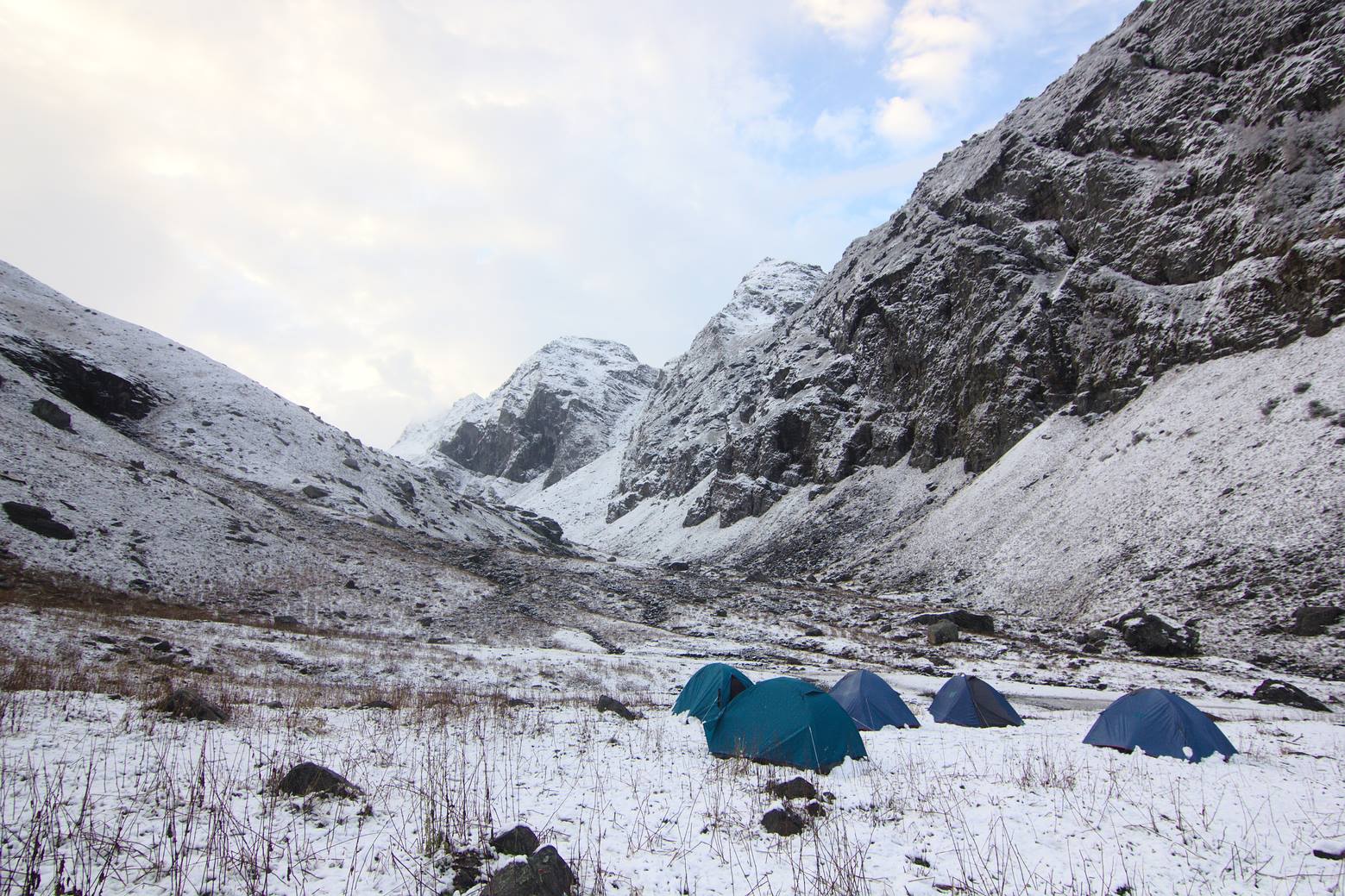
Camping in the designated meadow sites adjacent to the GMVN rest house is one of the trek's great highlights: the meadow is broad and flat, the Milky Way is vivid on clear nights, and the dawn alpenglow on Swargarohini's ridgeline is worth every layer of thermal clothing you packed. Follow eco-guidelines strictly — no open fires, no waste left behind.
What each day actually looks like
This 6-day itinerary starts and ends at Dehradun, the most common base city for this trek.
Day 1 — Dehradun to Sankri via Road
Drive: ~200 km, 8–9 hours | Overnight: Sankri (1,900 m)
Depart Dehradun early morning (by 05:30 if possible) to reach Sankri before dark. The drive through Purola and Mori offers increasingly dramatic mountain scenery. Sankri is a well-developed trekking hub with multiple guesthouses, a small market, and ATM access (the last ATM before the trail). Collect your forest permits here if not already arranged. Rest well — the walking begins tomorrow.
Day 2 — Sankri/Taluka to Osla
Drive to Taluka: 12 km by jeep/road (~30 min) | Trek Taluka to Osla: ~11 km, 5–6 hours | Overnight: Osla (2,560 m)
A short jeep ride from Sankri brings you to Taluka, the official trek check post where permits are verified. The trail immediately enters the Tons river gorge, crossing suspension bridges and hugging cliff-face paths above the roaring river. Forest cover is dense: pine, deodar, and oak. The village of Osla appears dramatically at a bend in the valley — a cluster of traditional Garhwali stone houses around the Duryodhana temple. Homestay accommodation is warm and the local food (dal, rice, roti) is simple and satisfying.
Day 3 — Osla to Har Ki Dun Valley
Trek: ~9 km, 4–5 hours | Overnight: Har Ki Dun (3,566 m)
This is the most scenic day. The trail leaves Osla's treeline behind and enters open sub-alpine terrain. Views of Swargarohini's western face begin to dominate the skyline ahead. The valley floor widens; the Supin stream braids across glacial gravel. Arrive at the GMVN Tourist Rest House and camping meadow by early afternoon, leaving the rest of the day for acclimatisation walks and photography. Sunsets on the peak faces from here are extraordinary.
Day 4 — Exploration Day / Jaundhar Glacier Side Trip
Trek: Variable (4–7 km depending on objective) | Overnight: Har Ki Dun (3,566 m)
Use this rest-acclimatisation day for one of two objectives: a gentle walk further up the valley for closer peak views, or a more ambitious push toward the Jaundhar Glacier snout. The glacier approach is rough — take a local guide, start early (by 07:00), and carry warm layers because cloud typically builds by early afternoon. Alternatively, explore the Ruinsara Lake trail (approximately 6 km one-way from the valley; note: this may require an additional permit — verify with the forest check post). Spend a second night at the valley to enjoy stargazing from one of Uttarakhand's lowest light-pollution zones.
Day 5 — Har Ki Dun to Taluka
Trek: ~20 km (combined Har Ki Dun to Osla + Osla to Taluka), 7–8 hours | Overnight: Taluka or Sankri (1,900 m)
A long descent day requiring an early start (by 06:30). The return trail follows the same route in reverse. Many trekkers skip the Osla overnight on the return and push all the way to Taluka, cutting the itinerary by a day if needed. Pace yourself on the descents — tired knees on loose trail are the most common injury on this route.
Day 6 — Taluka to Sankri, Drive to Dehradun
Trek Taluka to Sankri (or jeep): ~12 km | Drive Sankri to Dehradun: 8–9 hours
An early departure from Sankri (by 06:00) is essential to reach Dehradun before nightfall. Alternatively, spend a final night in Sankri and return to Dehradun the following morning at leisure — a good option if your schedule allows.
When to go
Spring — April to June (Recommended)
The valley's most popular window. Rhododendrons (Rhododendron arboreum) carpet the lower slopes in crimson from late March through April. By May, the valley floor is green, skies are largely clear, and temperatures are comfortable (daytime 12–18°C at the valley, colder at night). Note: afternoon thunderstorms become frequent in June — start each day's walk before 09:00.
Monsoon — July to August (Not Recommended)
Heavy rainfall triggers landslides on the Dehradun–Sankri road and makes trail sections dangerously slippery. Leeches infest lower forest sections. The Forest Department may temporarily close the trail during extreme weather events. Avoid unless you have specific experience with monsoon trekking.
Autumn — September to November (Recommended — Best for Photography)
Post-monsoon clarity delivers the sharpest peak views of the year. Meadows turn gold and amber. Temperatures are cooler (5–15°C daytime at the valley in September, dropping sharply by November). October is arguably the single best month: stable weather, low humidity, and excellent visibility. Trail traffic remains modest compared to Kedarkantha or popular Kumaon routes.
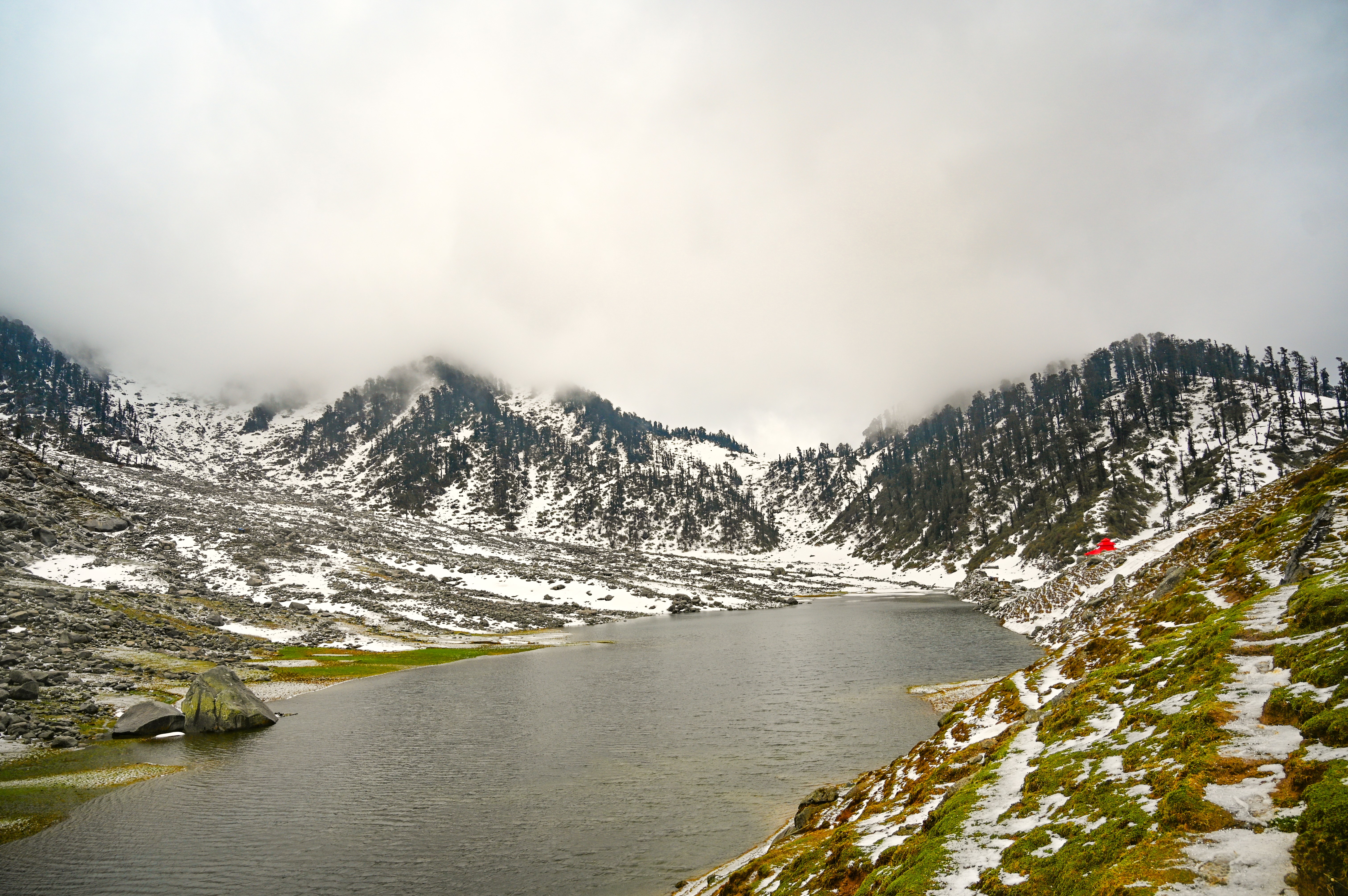
Winter — December to March (Experienced Only)
Snowfall transforms Har Ki Dun into a genuine snow trek. Temperatures drop to -10°C or lower at the valley; the GMVN rest house may be closed. Access requires snowshoes or microspikes, and the Sankri road can be blocked after heavy snowfall. Groups should be self-sufficient with winter camping gear and have cold-weather trekking experience. See our winter treks in India guide for preparation advice.
Recommendation for 2026 season: The windows of late April to early June and mid-September to late October offer the best combination of trail access, weather stability, and mountain views.
Har Ki Dun Trek Weather by Month
| Month | Daytime Temp (Valley) | Night Temp | Snowfall | Trail Status |
|---|---|---|---|---|
| April | 8–14°C | 0–4°C | Possible at higher elev. | Open |
| May | 12–18°C | 4–8°C | Unlikely | Open — Peak |
| June | 14–20°C | 6–10°C | None | Open, afternoon storms |
| July | 14–18°C | 8–12°C | None | Risky — landslides |
| August | 13–17°C | 7–11°C | None | Risky — landslides |
| September | 10–16°C | 4–8°C | None | Open |
| October | 6–14°C | -2–4°C | Unlikely | Open — Peak |
| November | 2–10°C | -5–0°C | Possible | Open with caution |
| December | -3–5°C | -10–-5°C | Heavy | Experienced only |
| January | -5–2°C | -12–-6°C | Heavy | Experienced only |
| February | -4–4°C | -11–-5°C | Heavy | Experienced only |
| March | 0–8°C | -6–0°C | Moderate | Transitional |
Temperature ranges are approximate. Verify current conditions with local operators before departure. [Flagged for review: monthly temperature data — confirm against 2026 IMD data.]
Is this trek right for you?
Overall rating: Easy to Moderate
Har Ki Dun is one of the most beginner-accessible multi-day treks in Uttarakhand. Here is why:
- Maximum altitude 3,566 m — well within comfortable acclimatisation range for most healthy adults
- No technical climbing, glacier crossing (on standard route), or fixed-rope sections
- Daily walking distances of 9–13 km on well-defined trails
- Gradual elevation gain spread over 3 ascent days reduces altitude sickness risk
- Suitable for ages 12–60 with basic cardiovascular fitness
Four-week preparation plan:
- Weeks 1–2: Daily 30-minute jogs or brisk walks; stair climbing (aim for 10 floors/day)
- Weeks 3–4: Increase to 45–60 minute runs or hikes with a 5–7 kg daypack; add squats and lunges for knee strength
- Practice wearing your trekking boots for at least two long walks before the trek to break them in
Trekkers with pre-existing cardiac, respiratory, or knee conditions should consult a physician before attempting this trek. Explore our acclimatisation guide for additional preparation tips.
What permits you need
A forest department permit is mandatory for all trekkers entering Govind Pashu Vihar National Park to access Har Ki Dun valley.
Where to obtain:
- Uttarkashi Forest Department office
- Sankri check post (most convenient for arriving trekkers)
- Taluka check post (last point before the trail proper)
Cost (2026 approximate rates):
- Indian nationals: ₹150–200 per person per day [Confirm 2026 fee schedule with Uttarkashi Forest Department before trekking]
- Foreign nationals: Higher fees apply — exact rate to be confirmed with the Forest Department
- Camera fees may apply for professional photography equipment
Documents required:
- Original government-issued photo ID (Aadhaar card, passport, or voter ID)
- Carry photocopies — check posts retain copies
Eco-tourism regulations:
- Single-use plastic is banned inside the national park — carry a reusable water bottle and cloth bag
- Campfires are prohibited except at designated fire zones (check current rules at Sankri)
- Camping only at designated sites; do not pitch tents in the buffer zone without permission
- All waste must be packed out — the "carry in, carry out" rule is enforced
For comprehensive permit information across Uttarakhand treks, see our Uttarakhand trekking permits guide.
Note: Permit rules, fees, and restricted area designations can change between seasons. Always verify current requirements directly with the Uttarkashi Forest Department before your trek.
What this trek will cost you
DIY Cost Breakdown (Per Person, 6 Days)
| Item | Estimated Cost (₹) |
|---|---|
| Transport: Dehradun–Sankri–Dehradun (shared jeep) | ₹1,000–1,600 |
| Accommodation: Sankri guesthouse (1 night) | ₹300–600 |
| Accommodation: Taluka guesthouse (1 night) | ₹200–400 |
| Accommodation: Osla homestay (1–2 nights) | ₹300–500/night |
| GMVN rest house / camping fee (1–2 nights at valley) | ₹200–500/night |
| Forest permits (5 trekking days × ₹150–200) | ₹750–1,000 |
| Local guide | ₹800–1,200/day |
| Porter (optional) | ₹700–1,000/day |
| Meals (trail food, guesthouses) | ₹400–600/day |
| Total DIY estimate (6 days, with guide) | ₹8,000–14,000 |
Porter hire adds approximately ₹4,200–6,000 to the total. Guide hire for 5 trekking days adds ₹4,000–6,000. [Flagged for review: all cost figures — confirm 2026 rates with local operators and Sankri guesthouses.]
Organised Package Cost
₹12,000–22,000 per person for a fully inclusive 6-day package from Dehradun, depending on operator quality, group size, and accommodation standard.
Packages typically include: transport, accommodation, guide, cook, camping equipment, all meals on trail, and permits.
DIY vs. Organised Package:
| Factor | DIY | Organised Package |
|---|---|---|
| Cost | Lower (₹8K–14K) | Higher (₹12K–22K) |
| Flexibility | Full | Fixed itinerary |
| Logistics burden | High | Minimal |
| Language/navigation | Guide required | Included |
| Best for | Experienced trekkers | First-timers, solo travellers |
For budget-conscious trekkers with prior Himalayan experience, DIY with a locally hired guide from Sankri is excellent value. First-timers or those short on time are better served by an organised package — the logistics between Dehradun, permits, accommodation bookings, and porters can be time-consuming to coordinate independently.
What to pack
For a full gear guide, see our trekking gear buying guide.
Clothing (Layering System)
- Thermal base layer (top and bottom) — merino wool or synthetic
- Mid-layer fleece or down jacket
- Waterproof and windproof outer jacket (Gore-Tex or equivalent)
- Trekking pants × 2 (quick-dry)
- Warm hat / balaclava
- Fleece-lined gloves
- Buff / neck gaiter
- Trekking socks × 4 pairs (wool recommended)
- Underwear × 3–4 (moisture-wicking)
Footwear
- Waterproof ankle-support trekking boots (broken in before the trek)
- Camp sandals or lightweight shoes
- Gaiters (essential for snow sections in winter and early spring)
Gear
- 50–60 L backpack with rain cover
- Trekking poles (pair — critical for river crossings and descents)
- Headlamp + spare batteries
- Sleeping bag rated to -10°C (do not compromise on this)
- Sleeping bag liner (adds 3–5°C warmth, lightweight)
- Sunglasses (UV400 or Category 3–4)
- Sunscreen SPF 50+
- Lip balm with SPF
- Water bottles × 2 (1L each) or hydration reservoir
- Water purification tablets or filter
Documents
- Original photo ID (Aadhaar / Passport)
- Photocopies of ID × 3
- Forest permits
- Emergency contacts list (laminated)
- Travel insurance documents
Medications & First Aid
- Diamox (Acetazolamide) for altitude sickness prevention — consult a doctor before use
- Ibuprofen / paracetamol
- Antihistamine
- Blister plasters / moleskin
- Antiseptic cream and bandages
- ORS / electrolyte sachets × 10
- Personal prescription medications
Food & Snacks
- Energy bars × 10–15
- Dry fruits and nuts (trail mix)
- Dark chocolate
- Instant noodles / meal sachets (backup)
- Electrolyte powder sachets
Recommended gear for this trek
Staying safe on the mountain
Altitude & Acclimatisation
- Ascend gradually — the itinerary above is designed to limit daily altitude gain to a safe rate
- Hydrate consistently: 3–4 litres of water per day on the trail
- Recognise AMS (Acute Mountain Sickness) symptoms: persistent headache, nausea, dizziness, loss of appetite, difficulty sleeping
- If symptoms worsen, descend immediately — do not ascend further with AMS
- Carry Diamox as a preventive measure (consult a doctor for dosage)
- Review our acclimatisation guide before departure
Weather & Daily Routine
- Afternoon thunderstorms are common in May–June; start each day's walk before 08:00 to reach camp by early afternoon
- Check weather forecasts at Sankri before departing each day (guides will have local updates)
- Carry a waterproof pack cover and emergency poncho at all times
Emergency Contacts
- Uttarkashi District Emergency Helpline: 1800-180-4236 []
- Nearest hospital: Purola (approximately 60 km from Sankri by road)
- Uttarkashi District Hospital: Available for serious emergencies
- Carry a satellite communicator (e.g., Garmin inReach) if trekking in off-peak months when mobile signal is absent
- Inform your guesthouse owner or guide of your daily plan and expected return time
General Safety
- Do not trek solo in the Har Ki Dun valley without prior high-altitude experience — conditions can change rapidly
- Keep a safe distance from Himalayan wildlife: Himalayan brown bear (rare but present in the national park), Himalayan monal, snow leopard (very rare)
- River crossings should be attempted only when water levels are manageable — after heavy rain, wait for levels to drop
- Follow Leave No Trace principles rigorously inside Govind Pashu Vihar National Park
Similar treks to explore
Kareri Lake Trek: Complete Guide for 2026
Plan your Kareri Lake trek with our 2026 guide covering route, difficulty, permits, cost, packing list, best time to visit, and day-wise itinerary.
Buran Ghati Trek: Complete Guide 2026
The Buran Ghati Trek is a difficult 40 km trail in Himachal Pradesh crossing a 4,700 m pass with India's only glacier rappel descent on a mainstream trek.
Indrahar Pass Trek: Routes, Difficulty & Best Time
Indrahar Pass trek is a moderate-to-difficult 4-day route in the Dhauladhar range, starting from McLeod Ganj and reaching 4,342 m (14,245 ft). Best done September–October.
Common questions answered
Har Ki Dun is rated easy to moderate. The maximum altitude of 3,566 m is well within the safe range for most healthy adults, and the trail requires no technical climbing. Daily distances of 9–13 km are manageable for anyone with basic cardiovascular fitness. The trek is suitable for ages 12–60 and is an excellent first Himalayan multi-day experience.