Why Lamkhaga Pass Trek is on every trekker's list
Lamkhaga Pass Trek connects Chitkul in Himachal Pradesh to Harsil in Uttarakhand via a 5,282 m glaciated crossing — a 7–8 day, Grade D route for experienced Himalayan trekkers only.
At 5,282 metres (17,329 feet), Lamkhaga Pass cuts through the greater Himalayan range in one of the least-visited corridors in the Indian Himalaya. It is the thread that joins the Baspa Valley in Kinnaur district, Himachal Pradesh to the Bhagirathi Valley in Uttarkashi district, Uttarakhand — a geographic and cultural seam where Kinnauri architectural traditions give way to Garhwali stone villages almost overnight.
This is not a trail for beginners. Lamkhaga Pass demands glaciated terrain navigation, altitude resilience, multi-day self-sufficiency, and a willingness to operate far from rescue infrastructure. In return, it delivers the kind of raw, uncrowded Himalayan experience that is increasingly rare in 2026: no teahouse network, no cell signal, no crowds at the top. Just ice, rock, altitude, and the horizon.
The 2026 trekking season has seen growing interest in remote high-altitude crossings among India's experienced trekking community, making this guide more relevant than ever — even as the trail itself remains mercifully unknown to the masses.
In a decade where treks like Rupin Pass and Pin Parvati have become household names in trekking circles, Lamkhaga Pass occupies a different category entirely. It is the prestige route whispered about among serious Himalayan trekkers: technically engaging, culturally layered, and genuinely remote.
Extreme remoteness is the defining characteristic. From the moment you leave Chitkul — itself one of India's highest villages — you enter a valley where the last road is behind you and the next motorable point is Harsil, two states away. There are no rescue posts, no lodges, and no bail-out options for 3–4 days in the middle section.
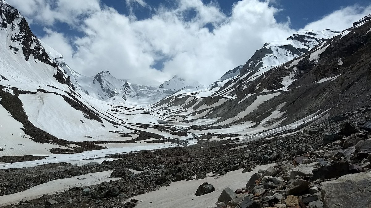
Glacier travel features prominently on the approach to the pass and on the descent towards Kyarkoti. The crossing itself traverses permanent snow and ice, requiring crampons, an ice axe, and the skill to use both. This is not a scree scramble with a snow patch at the top — it is genuine high-altitude mountaineering-adjacent travel.
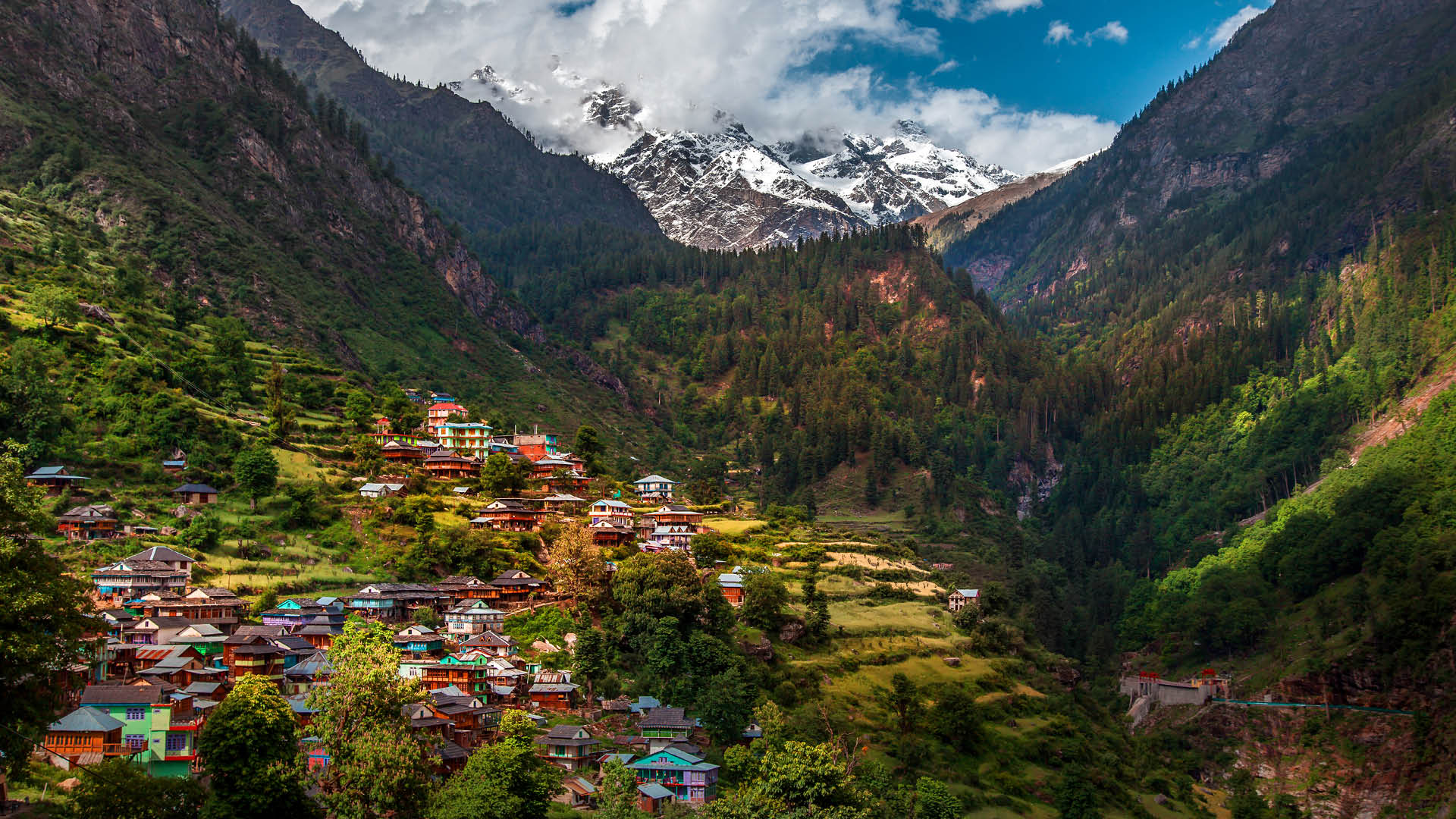
Cultural transition adds a dimension absent from single-state treks. You depart through the flat-roofed, poplar-lined villages of Kinnaur, cross a Himalayan watershed, and arrive in the green river gorges of Uttarakhand. The food, language, architecture, and even the colour of the prayer flags shift as you descend toward Harsil.
Near-zero crowd density sets it apart from even other 'remote' treks. On popular routes you share camps; on Lamkhaga, you may not see another trekking party for the entire crossing.
This trek appears consistently on lists of remote high-altitude treks in India alongside routes like Kang La and Miyar Valley — but it remains less documented and less guided than its peers, which is precisely part of its appeal.
At a glance
The route at a glance
The standard direction of travel is Chitkul to Harsil (west to east), although the reverse is possible. West-to-east is preferred because the longer, more gradual ascent up the Baspa Valley allows better acclimatisation before the technical pass crossing, while the descent into the Bhagirathi Valley is steep but shorter.
Full route: Chitkul (Baspa Valley, Himachal Pradesh) → Nagasthi → Lamkhaga Base Camp → Lamkhaga Pass (5,282 m) → Kyarkoti → Harsil (Bhagirathi Valley, Uttarakhand)
Total distance: Approximately 65–70 km
The trail crosses glacial moraines, permanent snowfields, boulder fields, and several unbridged stream crossings in the lower valleys. The glacier section between base camp and the pass requires roped travel when snow bridges are present in early season. On the Uttarakhand side, loose scree and a steep initial descent demand careful footwork and trekking poles.
Route maps with GPS waypoints are not commercially available in standardised form as of 2026. Teams are strongly advised to load a topo map onto a dedicated GPS device (not just a phone) and carry a printed 1:50,000 Survey of India sheet for the region. A local guide who has crossed recently is the most reliable navigation resource.
Elevation Profile at a Glance
| Campsite / Waypoint | Altitude |
|---|---|
| Chitkul (start) | 3,450 m (11,319 ft) |
| Nagasthi | ~3,700 m (~12,139 ft) |
| Lamkhaga Base Camp | ~4,600 m (~15,092 ft) |
| Lamkhaga Pass (high point) | 5,282 m (17,329 ft) |
| Kyarkoti | ~3,200 m (~10,499 ft) |
| Harsil (finish) | ~2,620 m (~8,596 ft) |
Key Landmarks and Camping Sites
Chitkul (3,450 m): The last village of the Baspa Valley and the traditional end of the motorable road. Camping is possible near the village on flat ground by the river. Freshwater is available from streams. The site accommodates small to medium groups easily. Basic provisions (dry food, eggs, local staples) can be purchased here in 2026, though supply is limited and unreliable — carry full rations from Reckong Peo or Sangla.
Nagasthi (~3,700 m): A meadow campsite in the upper Baspa Valley, roughly a day's walk above Chitkul. The terrain is grassy with reliable stream water in July–September. Capacity is moderate. This is a good camp for groups that need a shorter first day or arrive at Chitkul late.
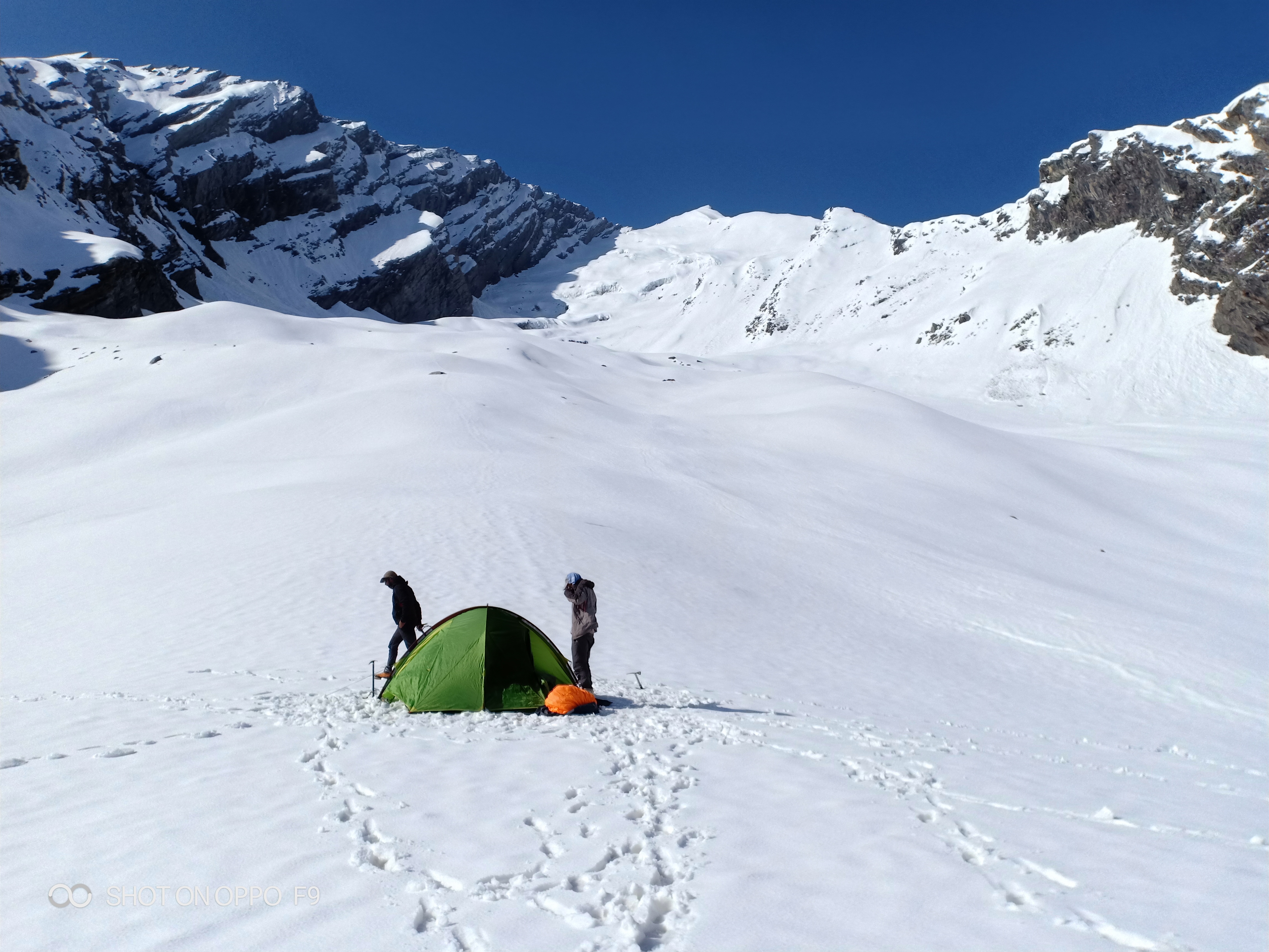
Lamkhaga Base Camp (~4,600 m): The last flat campsite before the pass. Water availability depends on season — snowmelt is the primary source and should be treated. Moraine terrain; exposed to wind. Capacity is limited, and arriving early to secure a wind-sheltered tent position is wise. Acclimatisation walk to 4,900–5,000 m recommended the afternoon before pass day.
High Camp (optional, ~5,000 m): Some teams place a high camp to shorten summit day. This is only advisable for very experienced teams and when conditions permit. Not a fixed camp with infrastructure — just a tent platform on snow or moraine.
Kyarkoti (~3,200 m): The first significant campsite on the Uttarakhand side, after the steep descent from the pass. Shelter and flat ground available. Stream water from glacial melt. This camp represents a significant altitude drop and a major morale boost after the crossing.
Harsil (~2,620 m): Trek finish point. Harsil is a small military-adjacent settlement in the Bhagirathi Valley with basic guesthouses and access to taxis toward Uttarkashi. See the Harsil Valley guide for accommodation and local logistics.
Reaching Chitkul (Trek Start)
Chitkul is in the upper Baspa Valley, Kinnaur district, Himachal Pradesh.
- By bus: HRTC buses run from Shimla to Reckong Peo (approximately 8–9 hours). From Reckong Peo, take a shared taxi or local bus to Sangla (~1.5 hours) and then to Chitkul (~1 hour).
- By taxi/private vehicle: Delhi to Chitkul can be done in 2 days (Delhi → Shimla/Narkanda overnight → Chitkul via Reckong Peo). Shimla to Chitkul in one long day is possible with an early start.
- Nearest airport: Shimla (limited connectivity) or Chandigarh (more reliable). From Chandigarh, Reckong Peo is approximately 10–12 hours by road.
- Road conditions: The road beyond Sangla toward Chitkul is narrow and subject to seasonal damage. Check HRTC and local transport updates before travel, especially in June.
See the Chitkul village guide for accommodation options before the trek.
Exiting at Harsil
Harsil is in the upper Bhagirathi Valley, Uttarkashi district, Uttarakhand.
- Harsil to Uttarkashi: Approximately 2 hours by taxi/shared jeep. Uttarkashi has bus connections onward.
- Uttarkashi to Rishikesh: Approximately 5–6 hours by bus or taxi.
- Uttarkashi to Dehradun: Approximately 4–5 hours.
Critical logistics note: Harsil is a small settlement with limited transport. Arrange your pickup or onward transport in advance. Do not arrive at Harsil expecting to find a taxi immediately, particularly in late afternoon. Your trekking agency or guide should coordinate this. If doing the trek independently, call ahead to fix a vehicle from Uttarkashi to meet you at Harsil on your expected exit day.
Because this is a one-way trek, you will need to either position a second vehicle at Harsil before you start, or rely on your operator to manage the logistics across two states. This inter-state transport coordination is one practical advantage of using a registered agency for this particular route.
See also: Uttarakhand treks | Himachal Pradesh treks
What each day actually looks like
This 7–8 day itinerary includes an acclimatisation day at Chitkul and a buffer day. Both are non-negotiable on a route of this seriousness.
Day 1 — Drive to Chitkul / Acclimatisation
Arrive at Chitkul by road (see transport section). Altitude: 3,450 m. Rest, hydrate, and eat a light meal. Short acclimatisation walk of 1–2 hours above the village (gain 200–300 m, then descend). No alcohol. Organise permits, confirm guide and porter arrangements, and do a final gear check.
Day 2 — Chitkul to Nagasthi
Distance: ~10–12 km. Altitude gain: ~250 m. Walking time: 5–6 hours. The trail follows the Baspa River upstream through pastures and light forest, gradually opening into wider valley terrain. Relatively straightforward day. Camp at Nagasthi meadow. Water from stream.
Day 3 — Nagasthi to Lamkhaga Base Camp
Distance: ~10–12 km. Altitude gain: ~900 m. Walking time: 6–7 hours. The trail steepens significantly as you leave the valley floor and begin climbing moraine ridges. The landscape becomes increasingly glaciated. Camp at base camp (~4,600 m). This is the most demanding acclimatisation day — take it slowly, eat well, and hydrate aggressively.
Day 4 — Base Camp to Lamkhaga Pass, Descend to Kyarkoti
Distance: ~12–14 km. Altitude gain: ~682 m to pass; then descent ~2,082 m to Kyarkoti. Walking time: 9–12 hours. The longest and most critical day. Start at first light (by 4:00–5:00 am) to avoid afternoon weather. The ascent to the pass crosses snow and glaciated terrain — crampons and ice axe in use from approximately 4,900 m. The pass itself is narrow and exposed. Descent to Kyarkoti is steep on scree and loose rock. Arrive at Kyarkoti camp before sunset. This is a very long day; some teams break it with a high camp.
Day 5 — Kyarkoti to Harsil
Distance: ~18–20 km. Altitude loss: ~580 m. Walking time: 6–8 hours. A longer but lower-altitude day as you descend through the Bhagirathi drainage toward Harsil. Trail is more defined on this side. Celebrate on arrival — you have completed the crossing.
Day 6 — Buffer / Contingency Day
Built into every responsible itinerary for this route. Weather delays on pass day, a team member with AMS, an injury, or a stream crossing made impassable by overnight rain can all cause a one-day slip. This day also allows time to exit Harsil toward Uttarkashi without rushing.
Day 7/8 — Exit to Uttarkashi / Onward
Harsil to Uttarkashi by taxi (~2 hours). Onward to Rishikesh or Dehradun depending on your return route.
Acclimatisation Day: What to Do in Chitkul Before the Trek
Chitkul sits at 3,450 m — high enough that arriving from the plains and immediately starting upward movement is a risk. An acclimatisation day here is not optional; it is the foundation of your safety protocol for everything above.
What to do: Take a 1.5–2 hour hike on the trail above the village, gaining 200–300 vertical metres, then return. This activates the body's altitude adaptation without stressing it. Visit the Mathi temple, observe the village life, and eat carbohydrate-rich meals. Drink 3–4 litres of water. Avoid alcohol entirely.
How to reach Chitkul from Shimla: Shimla → Narkanda → Rampur → Reckong Peo by HRTC bus or hired taxi (approximately 8–9 hours). From Reckong Peo, shared taxis or private cabs run to Sangla (~1.5 hours) and onward to Chitkul (~1 hour). The road beyond Sangla is narrow and mountain conditions apply — confirm road status before travel, especially in June and after heavy rain. See also: Inner Line Permit guide for Himachal.
When to go
Mid-July to mid-September is the optimal window for the 2026 trekking season. This is when the pass is most consistently passable, stream crossings are manageable, and weather windows are long enough for a safe summit bid.
June – early July: The pass retains heavy winter snowpack. Crevasse risk on the glacier is elevated because bridging snow is still thick and unstable. Only teams with glacier travel experience and appropriate equipment should attempt this period. Days are long, which helps, but conditions require a higher technical skill level.
Mid-July to mid-September (optimal): Snow consolidates on the pass and the glacier surface is more predictable. Wildflowers are at their peak in the valley sections. Afternoons bring convective clouds and occasional thunderstorms — standard Himalayan behaviour — so early starts are essential. Expect sub-zero temperatures at base camp and the pass even in this window.
October: Early snowfall can close the pass rapidly. Temperatures at night near the pass drop to -15°C or below. The window is narrow and weather forecasting in this region is unreliable beyond 48 hours. October crossings have been turned back by sudden snowfall. Only consider this month if you are an experienced winter mountaineer with full cold-weather kit.
Avoid: Sustained heavy monsoon periods (usually late July–August peaks) can make lower valley stream crossings dangerous and unpredictable. The pass itself is above the monsoon's main influence, but the approaches through the Baspa Valley floor can be affected by flash flood events.
Year-round reality near the pass: Nights are sub-zero at base camp and above, in every season. A sleeping bag rated to -10°C comfort is minimum; -15°C is safer for the pass high camp.
Is this trek right for you?
Lamkhaga Pass is rated Grade D — Very Difficult under Indian trekking grading standards. This is the highest standard civilian trekking grade, placing it in the same category as routes that border technical mountaineering.
Why Grade D:
- Sustained glaciated terrain requiring crampons and ice axe
- Altitude above 5,000 m for multiple hours on summit day
- Extreme remoteness: no rescue or evacuation infrastructure for 3–4 days in the mid-section
- River crossings that can become dangerous after overnight rain
- High daily distances with significant elevation change
- Unpredictable high-altitude weather
Minimum experience required: At least two prior Himalayan treks above 4,000 m, including at least one with a technical pass crossing. Prior glacier travel experience and knowledge of self-arrest with an ice axe is mandatory, not recommended. Teams with no glacier experience should enrol in a basic mountaineering course (available at institutes in Manali or Uttarkashi) before attempting this route.
Physical preparation: Begin a minimum 3-month programme before departure. Combine cardiovascular endurance work (running, cycling, stair climbing with a weighted pack) with strength training focused on legs, core, and back. VO2 max improvements directly translate to altitude performance. Practice carrying a 15–18 kg pack on multi-hour hikes well before the trek.
AMS risk: Significant above 4,500 m. Carry Diamox (Acetazolamide) and understand its use and side effects. Carry a pulse oximeter to monitor oxygen saturation. Know the golden rule: if in doubt, descend. See our full guide to altitude sickness prevention.
This trek is not suitable for first-time Himalayan trekkers, those with unmanaged cardiac or pulmonary conditions, or anyone who cannot commit to the physical preparation programme.
What permits you need
Permit requirements for the Lamkhaga Pass corridor involve documentation from both states. This is a mandatory section of your pre-trek planning.
1. Inner Line Permit (ILP) — Chitkul / Kinnaur Area, Himachal Pradesh
Chitkul falls within the Inner Line zone of Kinnaur district. All non-resident Indian citizens and all foreign nationals require an ILP to access this area.
- Where to obtain: SDM office, Reckong Peo (the main hub). Also available at the DC office in Shimla. Some registered trekking operators can facilitate this in advance.
- Cost: Approximately ₹100–300 per person
- Documents needed: ID proof (Aadhaar/passport), passport-size photos, completed application form
- Processing time: Usually same-day at Reckong Peo
- See our detailed Inner Line Permit guide for Himachal Pradesh
2. Forest / Wildlife Clearance
Portions of the approach trail may pass through or near the buffer zone of the Great Himalayan National Park (GHNP). If your route enters GHNP buffer territory, a separate wildlife clearance or forest department permit may be required.
3. Uttarakhand Entry / Harsil Area Clearance
Harsil and the upper Bhagirathi Valley fall near the Nelang Valley restricted zone in Uttarkashi district. Entry regulations in this region have changed in recent years as restricted areas were partially opened to tourism.
- Where to check: DM office, Uttarkashi. Contact in advance of your trek to confirm current rules.
- Important: Regulations in this region change seasonally and can be updated at short notice. Do not rely on information from previous years.
4. Group / Police Registration
All trekking groups are strongly advised to register with the local police at both Chitkul (Kinnaur district police) and at Harsil / Uttarkashi (Uttarakhand police). This is not always a formal legal requirement but it creates a trail for search and rescue in the event of an emergency.
Permit rules change seasonally. Always verify current requirements on the official Himachal Pradesh and Uttarakhand government portals, or through a registered local guide, in the weeks before your trek.
What this trek will cost you
DIY Budget (per person, 7–8 days, 2026)
| Item | Estimated Cost (INR) |
|---|---|
| Transport (Shimla/Delhi to Chitkul + Harsil to Dehradun/Rishikesh) | ₹3,000–5,000 |
| Permits (ILP + other clearances) | ₹500–1,000 |
| Local guide (₹2,500–3,500/day × 7 days) | ₹17,500–24,500 |
| Porter (₹1,800–2,500/day × 7 days, per porter) | ₹12,600–17,500 |
| Food and camping consumables | ₹1,500–2,000/day × 7 days = ₹10,500–14,000 |
| Gear rental (crampons, ice axe, tent, sleeping bag if needed) | ₹2,000–4,000 |
| DIY Total (per person, shared porter) | ₹40,000–60,000 |
Note: Porter cost above is per porter shared across 2–4 trekkers. DIY total assumes a 2-person team sharing one guide and one porter.
Organised Agency Package
Reputed agencies offering the Lamkhaga Pass trek in 2026 charge approximately ₹25,000–45,000 per person all-inclusive (covering transport from a fixed pick-up point, permits, guide, porter, meals, and camping equipment). The lower end of this range typically requires you to bring your own sleeping bag and personal gear.
Solo unsupported attempts are strongly discouraged and potentially dangerous. The route's remoteness means a solo trekker in difficulty has no realistic prospect of timely rescue. A minimum group of 4 trekkers with a registered local guide is the responsible standard.
For Lamkhaga Pass trek agencies, look for Sangla Valley-based local operators, Shimla-based mountain travel companies, and national operators. Before booking, verify IMF registration of the agency, guide certification level, emergency/rescue protocol, and whether a satellite communicator is included. Also see the FAQ below for agency guidance.
What to pack
Clothing
- Down jacket (minimum 600-fill, temperature rated to -10°C)
- Waterproof and windproof outer shell (hardshell jacket and trousers)
- Thermal base layers (top and bottom), 2 sets
- Mid-layer fleece or softshell
- Trekking trousers (2 pairs)
- Gaiters (essential for snow and scree sections)
- Balaclava and warm hat
- Sun hat
- Lightweight gloves + warm insulated gloves
- Merino wool or synthetic trekking socks (4–5 pairs)
Footwear
- Crampon-compatible double or stiff single trekking boots (see best trekking boots for India)
- Crampons or microspikes (see technical gear note below)
- Camp footwear / light shoes
Gear
- Ice axe (70 cm, standard walking axe)
- Trekking poles (2, with snow baskets)
- 65L backpack with rain cover
- Four-season tent rated to -15°C (or specialist guide provides)
- Sleeping bag: -10°C comfort rating minimum; -15°C recommended for high camp
- Sleeping mat (insulated foam or inflatable)
- Headlamp + spare batteries
- Water bottles (2 × 1 litre) + hydration bladder
- Water purification (filter or chemical tablets)
- Sunglasses (glacier-rated, Category 4)
- Sun protection (SPF 50+ sunscreen, lip balm)
Navigation
- GPS device loaded with topo maps and waypoints
- Printed 1:50,000 topo map
- Compass
- Satellite communicator (Garmin inReach or equivalent — strongly recommended)
Medical
- Diamox (Acetazolamide) — for AMS prevention/treatment; consult doctor before trek
- Dexamethasone (for HACE emergency use) — carry even if you hope not to use it
- Nifedipine (for HAPE emergency use)
- Pulse oximeter
- First aid kit (blister care, wound dressings, Ibuprofen, ORS sachets, antidiarrheals)
- Personal prescription medications
Documents
- All permits (ILP, forest clearance, Uttarakhand entry if required)
- Government photo ID (Aadhaar, passport)
- Trek insurance policy document with helicopter evacuation cover
- Emergency contact list (printed, not just on phone)
See the full high-altitude gear checklist for a printable version.
Technical Gear for Glaciated Terrain: Crampons vs Microspikes
Crampons vs. microspikes: Microspikes are adequate for consolidated snow on moderate slopes. Above ~4,900 m on the Lamkhaga approach, where the gradient steepens and ice can be exposed beneath surface snow, full 12-point crampons are the correct tool. Do not attempt the pass crossing with only microspikes in early season (June–July) or after overnight freeze. If in doubt, crampons.
Ice axe: Non-negotiable for this route. The primary use is self-arrest — the ability to stop yourself if you slip on a snow slope. Every member of the team must know how to perform a self-arrest before departure. The axe also provides balance and a secure point of contact on steep traverses.
Roped glacier travel: If your route crosses an area with snow bridges over glacial crevasses — most likely in June and early July — the team should travel roped together with appropriate harnesses and glacier rescue gear. This is the standard safety protocol for glaciated terrain and requires knowledge of crevasse rescue techniques. If your team does not have this skill, your guide must provide it or you should wait for safer seasonal conditions.
Recommended gear for this trek
Staying safe on the mountain
Altitude and AMS: Acute Mountain Sickness (AMS) can affect anyone above 2,500 m regardless of fitness. Know the symptoms: headache, nausea, dizziness, fatigue, loss of appetite. Above 4,500 m, monitor your oxygen saturation daily with a pulse oximeter. SpO2 below 80% at altitude is a warning sign — descend and assess. HACE (High Altitude Cerebral Edema) and HAPE (High Altitude Pulmonary Edema) are life-threatening emergencies requiring immediate descent and medication. If in doubt, descend immediately.
Weather windows: Start pass-day at 4:00–5:00 am. Aim to cross and begin descent before noon. In July and August, convective cloud builds rapidly over the high Himalaya in the afternoon, often producing electrical storms. If you see significant cloud building before 11:00 am on summit day, seriously consider turning back. No summit is worth a lightning strike above 5,000 m.
Wildlife: Lower valleys below 4,000 m have bear populations. Use noise (talking, bells) to avoid surprise encounters. Store food in sealed containers, away from tents.
River crossings: Glacial streams are lowest in the early morning and highest in the late afternoon when melt is peak. Cross early. Unbuckle your pack hip belt and sternum strap before entering water so you can shed it if you fall.
No solo crossings. This bears repeating. The Lamkhaga corridor has no search-and-rescue infrastructure within 3–4 walking days. A solo trekker with an injury or severe AMS in the middle section has no realistic prospect of timely help without a team present.
Emergency contacts:
- SDRF Uttarkashi: +91-1374-222351
- Uttarkashi District Hospital
- Reckong Peo Civil Hospital (Kinnaur side)
- HRTC emergency helpline (Himachal Pradesh): 1800-180-8099
- Your trekking agency's 24-hour emergency contact
Always trek with a registered local guide. This is a safety requirement, not a tourism formality.
Similar treks to explore
Friendship Peak Base Trek: Complete 2026 Guide
The Friendship Peak Base Trek is a 5–6 day moderate-to-difficult trek in Himachal Pradesh, starting at Dhundi (2480m) near Manali and reaching base camp at 4800–5000m beneath the 5289m summit.
Tosh Valley Trek: Guide to Parvati Valley's Hidden Gem
The Tosh Valley trek is a 3–4 km hike from Barshaini to Tosh Village (2,400 m) in Himachal Pradesh's Parvati Valley, rated easy to moderate and best done April–June.

Sar Pass Trek: Complete Guide 2026 (Route & Tips)
Sar Pass Trek is a 49 km moderate Himalayan trek in Himachal Pradesh, reaching 4,250 m, best done May–June over 5–6 days from Kasol to Barshaini.
Common questions answered
Lamkhaga Pass stands at 5,282 metres (17,329 feet) above sea level. Starting from Chitkul at approximately 3,450 m, trekkers gain roughly 1,832 vertical metres over three days of ascent. It is one of the highest non-motorised crossings linking the Kinnaur region of Himachal Pradesh with the Uttarkashi district of Uttarakhand, and spends the majority of the approach day above 5,000 m.