
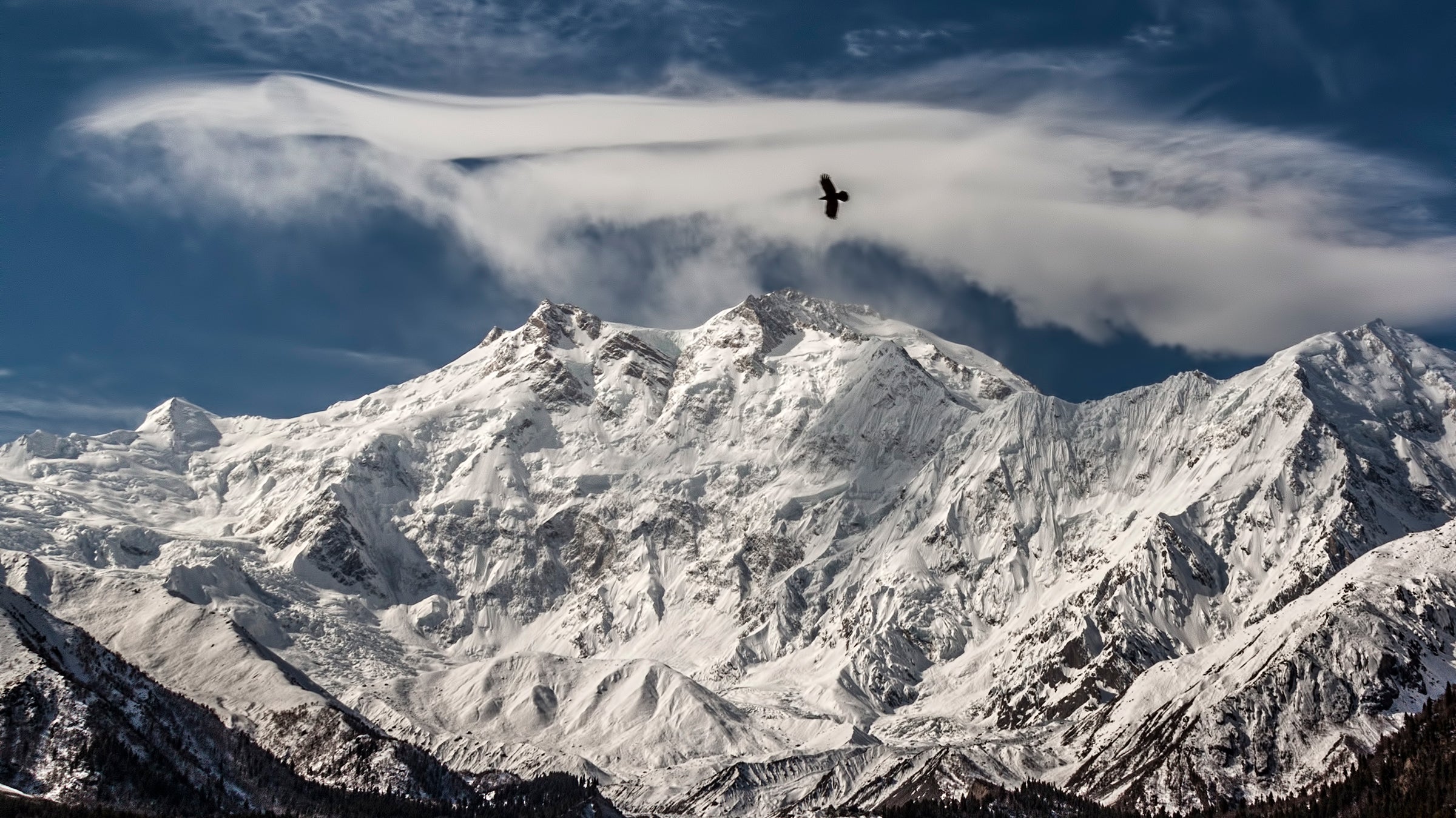
Why Nanga Parbat Trek is on every trekker's list
Standing at 8,126 metres, Nanga Parbat is the world's 9th highest peak and one of its most formidable. Nicknamed the Killer Mountain for its savage early climbing history, this giant in Pakistan's Gilgit-Baltistan region has claimed more lives per summit attempt than almost any other 8,000-metre peak. Yet for trekkers — not climbers — it offers something extraordinary: an approachable base camp journey through some of the Karakoram's most jaw-dropping landscapes.
The gateway is Fairy Meadows, a lush alpine plateau at around 2,865 metres that frames the mountain's immense Rakhiot face in a scene almost too cinematic to be real. Pine forests, wildflower meadows, and the sheer north wall of Nanga Parbat rising nearly 4,500 metres above you — it is, by any measure, one of the great mountain views on Earth.
This guide covers everything you need to plan a safe and unforgettable Nanga Parbat trek in 2026: the three main routes, a day-wise itinerary, the best seasons to visit, permit requirements, realistic costs in INR, a packing list, and critical safety information.
For trekkers who want an 8,000-metre experience without the technical demands of a K2 or Everest expedition, Nanga Parbat is a compelling answer. Here is why this destination continues to grow in popularity:
Legendary mountaineering history. In 1953, Austrian climber Hermann Buhl made one of the most audacious solo summit bids in history — 41 hours without oxygen, without a tent, at extreme altitude. Two decades later, Reinhold Messner completed the first solo ascent of an 8,000-metre peak here in 1978. Standing at base camp, you walk in the footsteps of giants.
Three distinct mountain faces. The Diamir face (west) is where Messner climbed and where most expeditions go today. The Rupal face (south) is the tallest mountain wall on Earth — a 4,500-metre rise of ice and rock. The Rakhiot face (north) is what trekkers see from Fairy Meadows, and it is astonishing.
Relatively accessible base camp. Compared to the K2 Base Camp trek, which demands 8–10 days of serious high-altitude hiking from Askole, the Fairy Meadows approach is logistically simpler and lower in maximum altitude. Fit beginners can reach Fairy Meadows itself; moderately experienced trekkers can push to Rakhiot Base Camp.
Diverse landscapes. The trail passes through dense Himalayan pine forests, open alpine meadows bursting with wildflowers in June, and raw moraines leading to the glacier. Few treks in Pakistan pack so much visual variety into such a compact journey.
Growing but not yet overcrowded. Nanga Parbat sees far fewer trekkers than the Annapurna or Everest circuits. In the 2026 season, visitor numbers are rising steadily, but the trails remain comparatively quiet — especially in September.
At a glance
Ask TrekSage about Nanga Parbat Trek
Get instant answers grounded in verified trek data — beginner-friendliness, best months, permits, packing, and more.
The route at a glance
There are three established trekking routes to Nanga Parbat's various base camps. Each offers a different perspective on the mountain.
1. Fairy Meadows / Rakhiot Base Camp Route (Most Popular)
- Start/End: Raikot Bridge (on the Karakoram Highway) → Tato Village → Fairy Meadows → Beyal Camp → Rakhiot Base Camp
- Approximate trekking distance: 18–22 km one way (Tato to Rakhiot Base Camp)
- Maximum altitude: ~3,969 m at Rakhiot Base Camp
- Elevation profile: Raikot Bridge (~1,000 m) → Tato Village (~2,230 m, jeep ride) → Fairy Meadows (~2,865 m) → Beyal Camp (~3,200 m) → Rakhiot Base Camp (~3,969 m)
- Character: Pine forest trail, alpine meadows, glacier moraine. Best for first-time visitors and moderately fit trekkers.
2. Rupal Valley Route (South Face)
- Start/End: Tarashing Village, Astore District → Rupal Base Camp
- Approximate trekking distance: 25–35 km one way
- Maximum altitude: ~3,900–4,100 m at base camp
- Elevation profile: Gradual ascent through the Rupal Valley, passing small shepherd settlements and crossing glacial streams before reaching the base of the world's highest mountain wall.
- Character: Remote, far fewer trekkers, requires prior high-altitude experience. Access from Astore District via Chilas or Gilgit.
3. Diamir Valley Route (West Face)
- Start/End: Diamir Valley, Diamer District → Diamir Base Camp
- Approximate trekking distance: 20–30 km one way
- Maximum altitude: ~4,100 m at Diamir Base Camp
- Elevation profile: Lower valley farmland transitions to high boulder fields and glacial terrain below the face where Messner climbed.
- Character: The least trekked of the three routes. Logistically more complex and requires a registered guide. Outstanding for those seeking total solitude.
For most trekkers visiting in 2026, the Fairy Meadows / Rakhiot route is the recommended choice. The rest of this guide focuses on this route.
What each day actually looks like
This 8-day itinerary covers the Fairy Meadows / Rakhiot Base Camp route, including travel days from Islamabad and Gilgit. Adjust based on your acclimatisation needs.
| Day | Stage | Altitude |
|---|---|---|
| 1 | Fly Islamabad → Gilgit; rest in Gilgit | ~1,500 m |
| 2 | Drive Gilgit → Raikot Bridge (Karakoram Highway, ~3–4 hrs); jeep Raikot Bridge → Tato Village; trek Tato → Fairy Meadows (2–3 hrs) | ~2,865 m |
| 3 | Acclimatisation day at Fairy Meadows; short walk to viewpoints; explore surroundings | ~2,865 m |
| 4 | Trek Fairy Meadows → Beyal Camp (4–5 hrs) | ~3,200 m |
| 5 | Acclimatisation day at Beyal Camp; explore moraine area; Nanga Parbat views | ~3,200 m |
| 6 | Trek Beyal Camp → Rakhiot Base Camp and return to Beyal (6–7 hrs round trip) | ~3,969 m |
| 7 | Descend Beyal → Fairy Meadows → Tato; jeep to Raikot Bridge | ~2,865 m |
| 8 | Drive Raikot Bridge → Gilgit; fly Gilgit → Islamabad | ~1,500 m |
Day 1 — Islamabad to Gilgit
Most trekkers fly into Islamabad and connect to Gilgit on PIA or Serene Air. Flights from Islamabad to Gilgit take approximately 50 minutes but are weather-dependent — allow a buffer day in your schedule. Rest in Gilgit, collect permits if not already arranged, and briefings with your guide.
Day 2 — Gilgit to Fairy Meadows (~2,865 m)
The drive along the legendary Karakoram Highway from Gilgit to Raikot Bridge takes 3–4 hours through spectacular gorge scenery. At Raikot Bridge, transfer to a 4WD jeep for the hair-raising drive up to Tato Village. From Tato, it is a 2–3 hour walk through pine forest to Fairy Meadows. Settle into your guesthouse or camp. The first view of Nanga Parbat at sunset is unforgettable.
Day 3 — Acclimatisation at Fairy Meadows
Do not rush higher on Day 3. Take a gentle exploratory walk around the meadows, photograph the mountain at dawn, and allow your body to adapt. Staying hydrated and resting well here pays dividends higher up.
Day 4 — Fairy Meadows to Beyal Camp (~3,200 m)
A 4–5 hour trek through thinning forest and across alpine terrain brings you to Beyal Camp, with Nanga Parbat's Rakhiot face filling the horizon. Basic camping facilities are available; some trekkers use tents.
Day 5 — Acclimatisation at Beyal Camp
Rest, explore the moraine ridges for closer glacier views, and prepare for the base camp push. Watch for ibex and golden eagles — Gilgit-Baltistan's wildlife is a genuine bonus.
Day 6 — Rakhiot Base Camp push (~3,969 m) and return to Beyal
An early start (5–6 am) is essential. The 6–7 hour round trip crosses glacial moraine and rocky terrain. At base camp, the scale of the Rakhiot face overhead is overwhelming. Return to Beyal for the night. This is the most demanding day — monitor yourself and your group for AMS symptoms.
Day 7 — Descent to Tato and Raikot Bridge
Descend steadily to Fairy Meadows, enjoy a final breakfast with the mountain view, then continue to Tato for the jeep ride down to Raikot Bridge. Transfer to Gilgit.
Day 8 — Gilgit to Islamabad
Depart Gilgit by air. Allow a half-day buffer for weather delays before any international connections.
For a detailed look at Gilgit-Baltistan travel logistics, including accommodation and local transport, see our regional guide.
When to go
May – June (Spring): The lower slopes are carpeted with wildflowers and the meadows are a vivid green. Some snow persists on higher trails toward Beyal Camp and Rakhiot Base Camp, and the path can be icy in early May. Temperatures are mild to cool. A beautiful time, though be prepared for occasional snowfall.
July – August (Peak Summer): The most popular window in the 2026 trekking season. Skies are generally clear, the base camp trail is snow-free, and accommodation in Fairy Meadows is fully operational. Expect more fellow trekkers. Mountain views are at their clearest. Daytime temperatures at Fairy Meadows are comfortable (10–18°C); nights drop to 0–5°C.
September (Post-Monsoon): An excellent alternative to peak season. Crowds thin noticeably, the air is crisp, and visibility can be exceptional. Temperatures are cooler than August. This is arguably the best month for photography.
October (Late Season): Still possible in early October but risky. Early snowfall can close the Tato–Fairy Meadows trail without warning. Only for experienced trekkers with flexible itineraries.
November – April (Closed Season): Heavy snowfall renders the routes impassable and accommodation is shut. Do not attempt the trek during this period.
For more on managing altitude at different times of year, see our altitude sickness prevention guide.
Is this trek right for you?
Overall rating: Moderate to Strenuous
The difficulty depends heavily on which route and how far you go:
- Fairy Meadows only (Day 1–3 of hiking): Accessible to reasonably fit beginners. The trail from Tato is well-marked, the altitude is manageable, and guesthouses provide comfortable rest. No technical skills required.
- Fairy Meadows to Rakhiot Base Camp: Moderate to strenuous. The moraine terrain above Beyal is rough and the maximum altitude of ~3,969 m will affect trekkers without prior high-altitude experience. AMS risk is real above 3,000 m.
- Rupal and Diamir routes: Strenuous. Prior experience on Himalayan or Karakoram treks above 3,500 m is strongly advised. Navigation is more complex and infrastructure is minimal.
Fitness preparation: Begin cardiovascular training 8–12 weeks before departure. Running, stair climbing, cycling, and loaded hiking are ideal. Practice with a loaded pack (10–15 kg) on hilly terrain.
Altitude: The maximum altitude on the standard Fairy Meadows / Rakhiot route is approximately 3,969 m — lower than many Himalayan treks but still high enough to cause acute mountain sickness (AMS) in unprepared trekkers. Extensions toward Rakhiot Glacier can push above 4,200 m.
Prior experience: At least one previous multi-day trek in mountainous terrain is strongly recommended before attempting the base camp extension. Consider a practice trek on routes detailed in our K2 Base Camp trek guide first if you want a longer high-altitude challenge.
What permits you need
This section is mandatory reading. Trekking without the required documents is illegal and will result in being turned back.
As of the 2026 trekking season, foreign nationals require the following documentation to trek in this area:
1. No-Objection Certificate (NOC)
- Issued by: Ministry of Interior, Government of Pakistan
- Required for: All foreign nationals trekking in restricted / sensitive zones in Gilgit-Baltistan
- Cost: Approximately PKR 600–1,000 (~INR 150–250)
- Processing time: 2–5 working days
- Where to obtain: Through a registered Pakistani tour operator (most efficient) or directly at the Ministry of Interior office in Islamabad
2. Gilgit-Baltistan Tourism Department Permit
- Issued by: GB Tourism Department, Gilgit
- Cost: Approximately PKR 1,500–2,500 (~INR 375–625)
- Where to obtain: GB Tourism office in Gilgit city, or arranged in advance through a registered operator
- Processing time: 1–3 working days in Gilgit
3. National Park / Protected Area Entry Fee
Parts of the Nanga Parbat area fall within protected conservation zones. An entry fee may apply depending on the route — confirm with the GB Tourism Department at the time of permit collection.
Practical advice: Arranging all permits through a registered tour operator is strongly recommended. Operators handle paperwork efficiently and are familiar with any 2026 regulatory changes. Carry multiple photocopies of your passport, Pakistani visa, and all permits — checkpoints on the Karakoram Highway and at Raikot Bridge will ask to see them.
Indian nationals: Pakistani visas are extremely difficult for Indian citizens to obtain and bilateral travel between the two countries remains subject to diplomatic conditions. Indian nationals should check current advisories with the Pakistan High Commission before making any plans. Most trekkers accessing Nanga Parbat are international travellers from Europe, North America, and East Asia.
See our Pakistan trekking permits guide for a comprehensive breakdown of the permit system across all major routes.
What this trek will cost you
DIY Breakdown (per person, approx. 10 days including travel days)
| Item | Estimated Cost (INR) |
|---|---|
| International flights to Islamabad (return, economy) | 25,000–40,000 |
| Islamabad–Gilgit flight (return, PIA/Serene Air) | 6,000–10,000 |
| Gilgit local transport and accommodation buffer | 2,000–4,000 |
| Jeep Raikot Bridge → Tato → Raikot Bridge (shared / private) | 1,500–2,500 |
| Fairy Meadows accommodation (guesthouses / camping, per night) | 500–1,500 per night |
| Registered guide | 2,500–3,500 per day |
| Porter (optional but recommended) | 1,500–2,500 per day |
| Food on trail | 500–1,000 per day |
| Permits (NOC + GB Tourism) | 200–500 total |
| Miscellaneous (gear, tips, contingency) | 3,000–5,000 |
| Estimated DIY Total (10 days) | ~INR 35,000–60,000 |
All INR figures are approximate 2026 estimates based on current PKR/INR exchange rates and should be verified close to departure.
Package Tours
All-inclusive guided packages from reputable Pakistani operators typically cost INR 80,000–1,50,000 per person (10 days), covering airport transfers, all ground transport, accommodation, guide, porter, permits, and meals on trek. International flights from India are generally not included.
Reputable operators to research include those registered with the Pakistan Tourism Development Corporation (PTDC) and the Adventure Tour Operators Association of Pakistan (ATOAP). Always verify operator credentials before booking.
Compare packing and cost strategies with our high-altitude trekking gear list to avoid overspending on equipment.
What to pack
Clothing
- Moisture-wicking base layers (top and bottom) × 2
- Mid-layer fleece or down jacket
- Insulated down jacket (essential for Beyal Camp and above)
- Waterproof and windproof shell jacket and trousers
- Trekking pants × 2
- Warm hat / beanie
- Sun hat or cap
- Lightweight gloves and heavier insulated gloves
- Merino wool or synthetic trekking socks × 4–5 pairs
- Thermal underwear for sleeping
Footwear
- Sturdy high-ankle waterproof trekking boots (broken in before the trip)
- Camp sandals or lightweight shoes
- Gaiters (useful above Fairy Meadows)
Gear
- Trekking poles (collapsible)
- Headlamp with spare batteries
- Sleeping bag rated to -10°C
- Daypack (25–35 L)
- Expedition duffel bag (60 L, for porter carry)
- Trekking umbrella (optional but useful for sun and light rain)
Documents
- Passport (with valid Pakistani visa)
- NOC and GB Tourism permits (multiple photocopies)
- Travel insurance documents (with helicopter evacuation cover — non-negotiable)
- Emergency contact card
Health & Safety
- Acetazolamide (Diamox) — consult your doctor before departure for AMS prevention dosage
- Personal first aid kit (blister care, antiseptic, bandages, pain relief, diarrhoea medication)
- Water purification tablets or a UV purification pen
- Sunscreen SPF 50+ (UV is intense at altitude)
- Lip balm with SPF
- Rehydration salts (ORS)
Electronics
- Power bank (large capacity — charging facilities are limited at Fairy Meadows and above)
- Offline maps downloaded (Maps.me or Gaia GPS with Gilgit-Baltistan maps)
- Satellite communicator (Garmin inReach or similar — strongly recommended)
- Camera with spare batteries
For a full breakdown of what to pack for high-altitude treks in the Karakoram, see our high-altitude trekking gear list.
Staying safe on the mountain
Acclimatisation
Ascend gradually. The classic rule — 'climb high, sleep low' — applies here. Do not skip the acclimatisation days built into the itinerary above. Drink 3–4 litres of water daily. Avoid alcohol in the first 48 hours at altitude.
Recognising AMS
Symptoms of acute mountain sickness include headache, nausea, dizziness, fatigue, and difficulty sleeping. If symptoms worsen or you develop High Altitude Pulmonary Oedema (HAPE) or High Altitude Cerebral Oedema (HACE) — characterised by breathlessness at rest, confusion, or loss of coordination — descend immediately. There is no altitude that is too low when life is at risk. See our detailed altitude sickness prevention tips.
Emergency Descent Plan
Before departing Fairy Meadows, agree with your guide on the emergency descent protocol. The route back to Tato and down to Raikot Bridge is the fastest way to lose altitude.
Local Rescue Services
The Aga Khan Agency for Habitat (AKAH) operates search and rescue services across Gilgit-Baltistan and is the primary emergency response organisation in the region. The nearest full hospital is in Gilgit city. Helicopter evacuation is available but expensive — travel insurance covering medical evacuation by helicopter is mandatory, not optional.
Security Situation
Gilgit-Baltistan has been generally safe for foreign trekkers in recent years, and the Nanga Parbat area around Fairy Meadows has seen significant improvement in the security environment since the 2013 Nanga Parbat Base Camp attack. That said, always check your government's current travel advisory before departure. Trek only with registered guides and inform your accommodation and guide of your daily plans.
Registered Guides
Never trek solo beyond Fairy Meadows. A registered guide not only enhances safety but is a legal requirement in some permit categories. Guides can be arranged in Gilgit through the GB Tourism Department or through your tour operator.
Weather Monitoring
Mountain weather changes rapidly. Check forecasts daily and be prepared to alter plans if conditions deteriorate. Your guide's local knowledge is invaluable here.
Pakistan Tourist Police
Tourist Police are present at key points along the Karakoram Highway and in Gilgit city. In an emergency, contact the local police or your tour operator's emergency line. Carry the number for AKAH rescue services.
Similar treks to explore
Snow Leopard Trek Hemis: The Ultimate 2026 Guide
The snow leopard trek in Hemis National Park, Ladakh, offers the world's best chance of spotting a wild snow leopard, with 70–80% guided sighting success rates
Padum to Darcha Trek: Complete High-Altitude Route Guide
The Padum to Darcha trek covers ~115–120 km in 8–9 days, crossing Shingo La (~5,060 m) between Zanskar and Lahaul.
Rumtse to Tso Moriri Trek: Complete Ladakh Trail Guide
The Rumtse to Tso Moriri trek is an ~80 km, 7–8 day strenuous Ladakh trail crossing Kyamar La (~5,460 m) and Polokongka La (~5,190 m), ending at Tso Moriri Lake
Common questions answered
Yes. Indian nationals require a valid Pakistani visa to enter Pakistan, which is currently very difficult to obtain due to the state of diplomatic relations between India and Pakistan. The bilateral travel situation has been complex for several years. Indian citizens interested in this trek should consult the Pakistan High Commission in New Delhi for the latest visa eligibility information and check the Government of India's travel advisories before making plans. Most trekkers visiting Nanga Parbat are nationals of other countries.
Nanga Parbat Trek — Latest News
GB reviews trekking rules after Broad Peak deaths
Gilgit-Baltistan reviews trekking regulations following Broad Peak fatalities. New safety protocols may affect Nanga Parbat trekkers planning expeditions.
Pakistan Roundup: Nanga Parbat, K2, Gasherbrum, Trango
Latest expedition reports for Nanga Parbat, K2, Gasherbrum, and Trango. Essential updates for trekkers planning Pakistan mountaineering expeditions.
Kili Pemba Sherpa completes all 14 eight-thousanders with Nanga Parbat summit
Sherpa climber achieves historic milestone summiting all 14 eight-thousanders via Nanga Parbat. Learn how this impacts trekkers planning Pakistan's challenging
Live Conditions
Real-time weather & trail status
Trail Conditions
Crowdsourced reports from trekkers who've done this route
Sign in to add a trip report
Find a Trek Buddy
Connect with trekkers planning the same route
No buddies yet for this trek
Sign in and be the first to post a planning signal.