Why Brahmatal Trek is on every trekker's list
The Brahmatal Trek is a 6-day easy-to-moderate winter trek in Uttarakhand reaching 3,682 m (12,090 ft), best done December–February for frozen lakes and Himalayan panoramas.
Imagine stepping onto a mirror-still frozen lake at dawn, surrounded by an amphitheatre of snow peaks — Trishul, Nanda Ghunti, and the distant massif of Mt. Kamet glowing gold in the early light. That is the promise of the Brahmatal Trek, one of Uttarakhand's best-kept winter secrets. Sitting at a maximum altitude of 3,682 m (12,090 ft), completed over six days, and graded easy-to-moderate, the Brahmatal Trek is a genuine gateway to Himalayan winter trekking. Whether you are a first-time trekker or a seasoned hiker looking for a quieter alternative to the crowds, this guide covers everything you need to know for the 2026 trekking season.
In a region packed with iconic trails, the Brahmatal Trek earns its place at the top of the list for several compelling reasons.
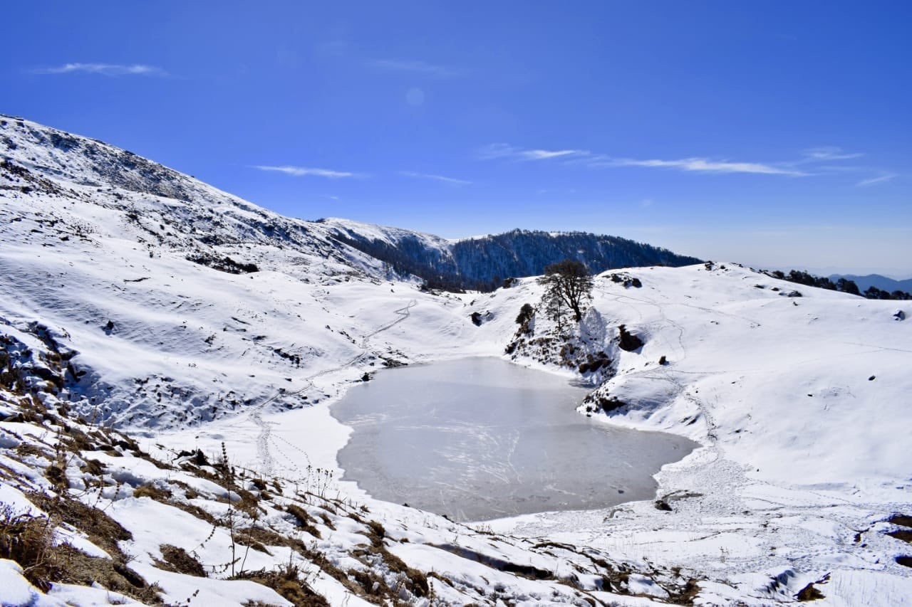
Frozen lakes that few treks offer. The twin lakes of Brahmatal (11,090 ft) and Bekaltal (9,800 ft) freeze solid in winter, creating ethereal icescape campsites that are genuinely rare among beginner-friendly Indian treks.
Unobstructed 360-degree Himalayan views. From Brahmatal Top, trekkers are rewarded with panoramic sightlines to Trishul (7,120 m), Nanda Ghunti (6,309 m), and the hulking Mt. Kamet (7,756 m) — a visual payoff that rivals treks twice as demanding.
A winter window when others close. Most Uttarakhand high-altitude treks shut from November to March. Brahmatal stays open and is, in fact, best during December to February when the snowfields are at their most spectacular.
Genuine solitude. Compared to the increasingly crowded Kedarkantha Trek, Brahmatal sees significantly fewer trekkers per season, preserving a more authentic wilderness experience.
Stunning forest corridors. The approach trails pass through dense stands of oak and rhododendron — rhododendron trees that burst into scarlet bloom by late March, offering a completely different kind of beauty in spring.
Trekker sentiment echoes consistently: Brahmatal is the trek that surprises you. Expectations are high, and the mountain still manages to exceed them.
At a glance
Ask TrekSage about Brahmatal Trek
Get instant answers grounded in verified trek data — beginner-friendliness, best months, permits, packing, and more.
The route at a glance
The standard Brahmatal Trek route is a roughly circular trail starting and ending at different points, with a total one-way distance of approximately 28 km. The classic circuit begins at Lohajung (2,320 m / 7,610 ft) and concludes at Wan Village, from where transport back to Lohajung or onwards to Kathgodam is arranged. Some operators run it as a full out-and-back for logistical simplicity.
Key waypoints:
- Lohajung Base Camp → Bekaltal Lake Camp → Brahmatal Lake Camp → Brahmatal Top → Daldum → Wan Village → Lohajung (drive)
Terrain profile: The trail opens through dense temperate forest for the first two days, transitioning into open alpine meadows and snowfields above 3,000 m. The final push to Brahmatal Top crosses exposed snowfields requiring careful footing in winter — microspikes or crampons are strongly advised.
A circular route option (Lohajung → Bekaltal → Brahmatal → Wan → Lohajung by road) is the most popular choice in 2026 and avoids retracing steps through the same forest sections.
For context on how this connects with the broader Uttarakhand trekking landscape, see our Roopkund Trek Guide — Roopkund's base area at Lohajung is shared with Brahmatal, making combination trips feasible for experienced trekkers.
Elevation Profile & Distance Breakdown
| Campsite / Waypoint | Altitude (ft) | Altitude (m) | Cumulative Distance from Lohajung | Terrain Type |
|---|---|---|---|---|
| Lohajung (Start) | 7,610 ft | 2,320 m | 0 km | Road head, village |
| Bekaltal Lake Camp | 9,800 ft | 2,987 m | ~6 km | Dense oak & rhododendron forest |
| Brahmatal Lake Camp | 11,090 ft | 3,380 m | ~10 km | Open meadow, snowfield |
| Brahmatal Top (Summit) | 12,090 ft | 3,682 m | ~14 km | Exposed snowfield, rocky ridge |
| Daldum Camp | ~10,500 ft | ~3,200 m | ~18 km | Forest edge, descending meadow |
| Wan Village (End) | ~7,800 ft | ~2,377 m | ~28 km | Village, terraced farmland |
Note: Brahmatal trek altitude figures and Brahmatal trek distance figures above are based on widely reported trail data. Cumulative distances are approximate — GPS readings vary by route variant. Flagged for verification.
Lohajung sits in Chamoli district, Uttarakhand, and is the shared base camp for both the Brahmatal Trek and the Roopkund Trek.
Nearest railhead: Kathgodam (~220 km, 8–9 hours by road). Well-connected to Delhi, Lucknow, and other major cities by train. See our How to Reach Kathgodam guide for train options.
Nearest airport: Pantnagar Airport (~240 km from Lohajung). Limited flight connectivity — primarily from Delhi. Most trekkers use rail to Kathgodam.
By road from Kathgodam: Shared taxis and private cabs operate regularly from Kathgodam's taxi stand to Lohajung via Karnprayag. Journey time is 8–9 hours depending on road and traffic conditions. UPSRTC buses also serve portions of this route (Kathgodam to Karnprayag), from where a connecting shared cab to Lohajung is available.
From Delhi: Overnight UPSRTC or private Volvo buses run from ISBT Anand Vihar to Kathgodam (~7–8 hours). Depart Delhi overnight, arrive Kathgodam at dawn, and connect to Lohajung for a same-day arrival.
Road conditions in winter: The mountain roads above Karnprayag can be icy or snow-affected in January–February. Check road conditions with local transport services 24 hours ahead of travel. Carry chains if driving a private vehicle.
⚠️ Transport fares cited are estimates. Verify current shared-cab fares at Kathgodam taxi stand or with your operator.
What each day actually looks like
The standard Brahmatal Trek itinerary runs across six days. Below is a detailed breakdown of each stage, including distance covered, altitude gain, difficulty rating, and key highlights.
Day 1 – Arrival at Lohajung & Acclimatisation
Altitude: 2,320 m (7,610 ft) | Drive from Kathgodam: ~220 km, 8–9 hours | Difficulty: Easy
Most trekkers depart Kathgodam or Rishikesh in the early hours to arrive at Lohajung by afternoon. The drive itself is spectacular — winding through the Kumaon hills along the Pindar valley road via Karnprayag. In winter, road conditions beyond Karnprayag can be icy; confirm conditions 24 hours before travel.
Lohajung is a small but well-equipped base camp village with guesthouses, hot meals, and basic medical facilities. Your first evening is for acclimatisation: explore the village, conduct a thorough gear check, confirm permits, and sleep early. Altitude here is modest enough that AMS is rarely a concern on Day 1, but hydration discipline should start immediately.
Highlight: First views of the high ridgeline above the village, and the friendly briefing from your trek leader or local guide.
Day 2 – Lohajung to Bekaltal Camp (9,800 ft)
Distance: ~6 km | Duration: 4–5 hours | Altitude Gain: ~1,190 ft | Difficulty: Easy-Moderate
The trek begins with a steady climb through magnificent oak and rhododendron forest. Trails are well-marked and the gradient is consistent — no dramatic scrambles, just a sustained uphill walk through increasingly beautiful woodland. In winter, frost clings to the branches and the forest is hushed.
Bekaltal Lake appears almost unexpectedly through the trees — a circular lake that sits in a forest clearing. In December and January, it is typically frozen solid, its surface a pale grey-blue sheet. Camp is pitched in the meadow beside the lake.
Highlight: The frozen Bekaltal Lake at sunset and your first genuinely remote Himalayan campsite.
Day 3 – Bekaltal to Brahmatal Lake Camp (11,090 ft)
Distance: ~4 km | Duration: 4 hours | Altitude Gain: ~1,290 ft | Difficulty: Moderate
A shorter day in distance but a meaningful altitude gain. The trail exits the dense forest and enters open alpine meadows — in winter, these are snow-covered blankets of white that make navigation dependent on your guide's familiarity with the route. Snow depth varies considerably: December typically sees 1–2 ft, January can bring 3–4 ft or more.
Brahmatal Lake camp, set beside the frozen lake at 3,380 m, is the highlight campsite of the trek. On clear nights — which are frequent in winter — the sky overhead is extraordinary. Temperatures will drop sharply after sunset; expect -5°C to -12°C at camp depending on the month.
Highlight: Stargazing from your sleeping bag porch with the frozen lake reflecting ambient starlight. An experience that repeatedly tops trekker reviews.
Day 4 – Summit Day: Brahmatal Top (12,090 ft) & Descent to Daldum
Distance: ~4 km to summit, ~8 km total with descent to Daldum | Duration: 6–8 hours | Altitude Gain/Loss: +1,000 ft / -1,590 ft | Difficulty: Moderate
An early start — typically 5:30–6:00 AM — is essential for summit day. The approach to Brahmatal Top crosses open snowfields where microspikes are non-negotiable in winter. The summit ridge offers the full panoramic reward: Trishul, Nanda Ghunti, and on clear days the enormous bulk of Mt. Kamet visible to the northwest.
Summit photography tips: Arrive at the top between 7:00–9:00 AM for the best light direction. The peaks face northeast-to-north from the summit, so early morning catches golden light on their faces. Carry lens-cleaning cloths — cold air and breath fog lenses quickly. Keep batteries warm in your inner pocket; cold kills camera battery life rapidly.
After summit time, the descent continues past Brahmatal Lake camp and down to Daldum, a forested campsite at approximately 3,200 m. The descent is steep in sections and can be slippery on packed snow — trekking poles are essential.
Highlight: The 360-degree Himalayan panorama from Brahmatal Top — the single most photographed moment of the trek.
Days 5–6 – Descent via Wan & Drive Out
Day 5 — Daldum to Wan Village: ~8 km, 4–5 hours | Difficulty: Easy-Moderate
The final descent takes you through rhododendron forest and eventually into the terraced fields around Wan Village (approximately 2,377 m). Wan is a traditional Garhwali village and a welcome reminder of the human landscape that exists below the snowline. Local tea stalls provide well-earned chai. Overnight in a village homestay or tent depending on your operator's arrangement.
Day 6 — Wan to Lohajung / Drive to Kathgodam: Drive 1–1.5 hours | Trek ends
A short shared-taxi or pre-arranged vehicle ride takes you back to Lohajung, or directly onwards toward Kathgodam. The drive from Lohajung to Kathgodam is 8–9 hours, typically arriving at Kathgodam by evening for onward train connections. Delhi-bound travellers can catch overnight trains from Kathgodam.
Highlight: The warm hospitality of Wan Village and the quiet satisfaction of a completed trek.
When to go
Unlike most Uttarakhand high-altitude trails, Brahmatal has a wide seasonal window — though each season offers a dramatically different experience.
Winter (December–February) — RECOMMENDED for 2026: This is peak season for the Brahmatal winter trek. Frozen lakes, deep snowfields, and the clearest mountain views of the year define this window. Nighttime temperatures at higher camps can plunge to -10°C to -15°C; daytime highs hover around 0°C to 5°C. Preparation and gear quality are critical. This is when Brahmatal is at its most iconic.
Spring (March–April): Snow begins melting, trails become muddier, but rhododendron forests burst into bloom. Views remain excellent. A good second choice for those unwilling to deal with deep snow camping.
Monsoon (July–September) — AVOID: The trail becomes dangerously slippery, leeches proliferate in the lower forest sections, and mountain views are almost entirely obscured by cloud. Not recommended.
Autumn (October–November): Crystal-clear skies and no snow. Beautiful for photography and comfortable for walking, but lacks the dramatic frozen-lake experience that defines Brahmatal's identity.
| Month | Avg. Daytime Temp (Top) | Avg. Night Temp (Camp) | Snow Cover | Crowd Level |
|---|---|---|---|---|
| December | 0°C to 3°C | -10°C to -13°C | Heavy | Moderate |
| January | -2°C to 2°C | -12°C to -15°C | Very Heavy | Moderate |
| February | 0°C to 5°C | -8°C to -12°C | Heavy | Low-Moderate |
| March | 4°C to 10°C | -3°C to -6°C | Melting | Low |
| April | 8°C to 15°C | 0°C to 4°C | Patches | Low |
| October | 5°C to 12°C | -1°C to -4°C | None | Very Low |
| November | 0°C to 6°C | -5°C to -8°C | Light | Very Low |
Temperature figures are approximate averages based on available trekking data. Actual conditions vary. Flagged for verification.
Is this trek right for you?
Overall difficulty: Easy-Moderate
The Brahmatal Trek is widely regarded as one of the most suitable winter treks for beginners in the Indian Himalayas. Here is why that rating holds:
- Maximum altitude of 12,090 ft (3,682 m) — high enough for a meaningful mountain experience, low enough that severe AMS is uncommon with proper acclimatisation.
- Gradual, manageable ascent profile — no single day demands more than 1,300 ft of altitude gain.
- No technical climbing — no roped sections, no ice axe work, though microspikes are required on summit day in winter.
- Well-marked trails with guide support widely available from Lohajung.
Fitness baseline for Brahmatal trek for beginners: A 30-minute jog (or brisk walk) three times per week for four weeks before the trek is sufficient preparation for most people. Core strength and ankle stability exercises are valuable additions.
Age range: Brahmatal has been completed successfully by trekkers aged 12 to 65. Children below 12 should be assessed individually given the cold-night camping demands in winter.
AMS risk: Altitude sickness remains a possibility above 3,000 m regardless of fitness level. Ascend slowly, hydrate well (3–4 litres per day), and never ignore persistent headache, nausea, or loss of coordination. Descend immediately if symptoms worsen. See our dedicated guide on altitude sickness prevention and our beginner's guide to Himalayan trekking for detailed preparation advice.
What permits you need
Trekking in the Brahmatal area requires a forest department entry permit issued by the Uttarakhand Forest Department. The trail passes through the buffer zone of the broader protected forest network in Chamoli district; some operators cite this under the Nanda Devi Biosphere Reserve administrative umbrella, though precise jurisdiction can vary — confirm current permit category at the Lohajung checkpoint or via the Uttarakhand Tourism portal before your trek.
Permit cost (2026 estimate): Approximately ₹150–₹250 per person per day of trekking. For a 5-day trekking portion (Days 2–6), this amounts to roughly ₹750–₹1,250 per person total.
⚠️ Exact 2026 permit fee rates should be confirmed directly with the Uttarakhand Forest Department or via the official Uttarakhand Tourism portal before travel, as permit fee structures are subject to revision.
Where to obtain permits:
- At the forest checkpoint in Lohajung — permits are routinely issued here for both individual and group trekkers.
- Online in advance via the Uttarakhand Tourism official portal (recommended to avoid morning queues in peak winter season).
Documents required: Government-issued photo ID (Aadhaar card, passport, or voter ID). Carry physical copies and digital backups.
Group size: No fixed group-size restriction is universally enforced on this trail, but commercial operators typically run groups of 8–15 people. Confirm any 2026 restrictions with the forest department.
For a comprehensive overview of permit processes across Uttarakhand treks, see our Uttarakhand Trek Permits Guide.
What this trek will cost you
Planning your Brahmatal trek budget for 2026? Here is a realistic breakdown across two approaches:
DIY Trek Budget (Per Person)
| Cost Head | Estimated Range (₹) |
|---|---|
| Kathgodam to Lohajung shared cab | ₹600–₹1,200 |
| Accommodation at Lohajung (1 night) | ₹500–₹800 |
| Camping gear rental (tent, sleeping bag, poles) per day | ₹300–₹600/day |
| Food (trail meals, Lohajung/Wan) per day | ₹400–₹600/day |
| Forest permit (5 trekking days) | ₹750–₹1,250 |
| Local guide (optional but recommended) | ₹800–₹1,200/day |
| Total DIY Estimate (6 days, without guide) | ₹8,000–₹14,000 |
DIY trekking requires strong route familiarity or local guide hire. In winter, navigating snow-covered trails without a guide significantly increases risk.
Guided Package (Per Person)
| Cost Head | Included? |
|---|---|
| All meals on trek | ✅ Yes |
| Tents and sleeping bags | ✅ Yes |
| Certified trek guide | ✅ Yes |
| Forest permits | ✅ Usually |
| Safety equipment | ✅ Yes |
| Transport (Kathgodam ↔ Lohajung) | ✅ Some operators |
| Personal gear (boots, clothing) | ❌ No — bring your own |
| Travel insurance | ❌ No — buy separately |
Package price range (2026): ₹12,000–₹18,000 per person for a full 6-day guided package from reputed operators.
⚠️ Package prices vary significantly between operators and can change seasonally. Confirm current 2026 pricing directly with operators before booking.
For gear you don't own, see our Trekking Gear Checklist India for rental vs. buy guidance.
What to pack
Packing correctly for Brahmatal's winter conditions is non-negotiable — inadequate gear is the single most common reason trekkers have a miserable or dangerous experience. Bold items are must-haves for winter.
Clothing
- Thermal base layer (top and bottom) — merino wool or synthetic
- Mid-layer fleece jacket
- Down jacket (600-fill or higher)
- Waterproof and windproof hard-shell jacket
- Waterproof trekking trousers
- Snow gaiters
- Wool or synthetic socks × 4 pairs minimum
- Balaclava or neck gaiter
- Insulated gloves (waterproof outer shell)
- Thin liner gloves for layering
- Warm trekking hat
- Sunglasses (UV400 minimum — snow glare is severe)
Gear
- Trekking poles × 2
- Microspikes or crampons (essential for summit day)
- 50L backpack with rain cover
- Sleeping bag rated to -10°C minimum (-15°C recommended for January)
- Headlamp with spare batteries
- Dry bags or pack liners
Footwear
- Waterproof high-ankle trekking boots (broken in before the trek)
Nutrition
- Energy bars or trail mix
- Oral Rehydration Salts (ORS)
- Dry fruits and nuts
- Electrolyte powder sachets
Documents
- Government-issued photo ID (original + copies)
- Permit copies (print and digital)
- Travel insurance documents
- Emergency contacts list
Pharmacy / First Aid
- Diamox (acetazolamide) — consult a doctor before use
- Ibuprofen or paracetamol
- Blister treatment kit
- Antiseptic cream and bandages
- Lip balm and sunscreen SPF 50+
Staying safe on the mountain
Brahmatal is beginner-friendly, but the Himalayas demand respect from every trekker regardless of experience. Follow these guidelines for a safe 2026 trek.
Altitude sickness (AMS): Symptoms include persistent headache, nausea, dizziness, fatigue, and loss of appetite. If any symptom worsens or is accompanied by confusion or loss of coordination, descend immediately — this is a medical emergency. Never ascend further if experiencing AMS symptoms. For detailed guidance, see our altitude sickness prevention tips.
Weather monitoring: Check the 48-hour forecast before summit day using IMD (India Meteorological Department) or reliable mountain weather apps. Snowfall during ascent significantly increases avalanche and trail-loss risk. Brahmatal trek weather can shift quickly — a clear morning can become a whiteout by afternoon.
Turnaround policy: Set a firm turnaround time for summit day — typically 10:00–11:00 AM regardless of how close to the top you are. Descent in fading winter light on snowfields is dangerous.
Do not trek alone: Always trek with a group or certified local guide. The trail above Brahmatal Lake camp is not reliably marked under heavy snow.
Register at checkpoint: Sign the register at the Lohajung forest checkpoint before departing. This creates an official record of your trek for rescue coordination.
Frostbite prevention: Cover all exposed skin at high camp. Watch for early signs — numbness, white or pale skin on fingers, toes, ears, and nose. Rewarm gently; never rub frostbitten skin.
Hydration: Drink 3–4 litres of water daily on trek. Cold air suppresses the thirst response — drink on a schedule, not just when thirsty.
Emergency contacts:
- SDRF (State Disaster Response Force) Uttarakhand: 1070 / 0135-2710334 (verify current number before travel)
- Lohajung local rescue coordination: enquire with your guesthouse or permit officer on arrival
- District emergency helpline Chamoli: verify with local authorities on arrival
Similar treks to explore
Nubra Valley Trek: Routes, Permits & Best Time (2026)
The Nubra Valley trek is a 65–90 km high-altitude route in Ladakh crossing Khardung La (5,359 m) into a cold-desert valley at 3,048 m, completed in 7 days.
Sham Valley Trek: Complete Beginner's Guide (2026)
The Sham Valley Trek is Ladakh's most beginner-friendly high-altitude trek, reaching a maximum of ~3,700m over 4–5 days.
Stok Kangri Trek: Complete Guide for Climbers
The Stok Kangri trek is a high-altitude mountaineering route in Ladakh, India, reaching a summit of 6,153 metres — one of India's most accessible 6,000m+ peaks.
Common questions answered
Yes — the Brahmatal Trek is one of the most beginner-friendly winter treks in Uttarakhand. The trail is well-marked (with a guide), the maximum altitude of 12,090 ft involves no technical climbing, and daily altitude gains are gradual. A basic fitness level — the ability to walk briskly for 4–5 hours — is sufficient. Trekkers aged 12 to 65 regularly complete this route. The main challenge for first-timers is the cold camping conditions in winter, which are manageable with correct gear.
Live Conditions
Real-time weather & trail status
Trail Conditions
Crowdsourced reports from trekkers who've done this route
Sign in to add a trip report
Find a Trek Buddy
Connect with trekkers planning the same route
No buddies yet for this trek
Sign in and be the first to post a planning signal.