Why Kedarkantha Trek is on every trekker's list
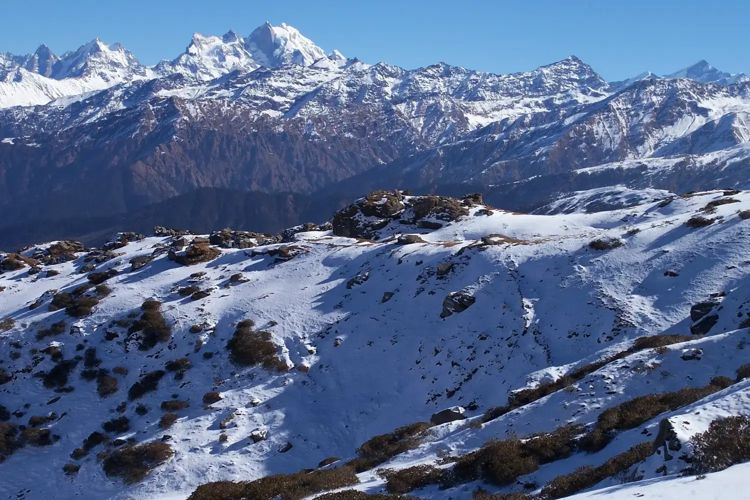
Imagine standing on a snow-blanketed summit at 12,500 ft as the first rays of sunrise ignite a panorama of Himalayan giants — Swargarohini, Bandarpoonch, Kedarnath, and Black Peak all visible in a single, breathtaking sweep. That moment is what draws thousands of trekkers to the Kedarkantha trek every winter season.
Nested in the Uttarkashi district of Uttarakhand and falling within the boundaries of Govind Pashu Vihar National Park, Kedarkantha is widely regarded as India's finest beginner winter trek. The numbers are reassuring: a summit altitude of 12,500 ft (3,810 m), a total round-trip distance of approximately 20 km, and a comfortable 4–6 day window that fits most working professionals' leave calendars. The gateway village of Sankri sits at roughly 6,400 ft (1,950 m) and is reachable from Dehradun — and by extension from Delhi — in about 12 hours.
This 2026 guide covers everything you need to plan a safe, well-budgeted, and truly memorable Kedarkantha trek.
With dozens of Himalayan treks competing for your attention, Kedarkantha earns its popularity for several compellingly practical reasons:
- Winter snow magic: From December through February the trail is buried under deep snow, transforming pine and oak forests into a fairy-tale landscape — rare among beginner-friendly treks.
- Beginner-accessible: Daily walking distances are short (4–6 km per stage), altitude gain is gradual, and the highest point is well within the range of most healthy adults.
- Close to Delhi: Sankri is roughly 500 km from Delhi. A comfortable overnight bus or a drive to Dehradun followed by a shared taxi puts you at the trailhead without a flight booking.
- Year-round availability: Unlike many high-altitude routes, Kedarkantha is trekable from October through June, with December–April being the sweet spot.
- Iconic summit sunrise: The pre-dawn summit push rewards trekkers with a 360-degree panorama that rivals treks costing twice as much.
- Varied terrain: Dense pine and oak forests give way to frozen alpine meadows, the jewel-like Juda Ka Talab frozen lake, and wide open snowfields near the summit.
- Strong trekking community: Operators like Indiahikes, Trek The Himalayas, and The Himalayan Plan run regular departures, making it easy to join a group.
Looking for other great winter options? Check out our guide to the best winter treks in India.
At a glance
Ask TrekSage about Kedarkantha Trek
Get instant answers grounded in verified trek data — beginner-friendliness, best months, permits, packing, and more.
The route at a glance
The classic Kedarkantha route is an out-and-back trail originating in Sankri (6,400 ft), the last motorable village in the Govind Wildlife Sanctuary zone. The trail climbs steadily through three distinct ecological zones before reaching the summit pyramid.
Trail character by zone:
- Lower forest belt (Sankri to Juda Ka Talab): Thick canopy of Himalayan pine, oak, and rhododendron. In winter the branches are weighed down with snow. Wildlife sightings of monal pheasant and Himalayan birds are common.
- Mid-alpine zone (Juda Ka Talab to Base Camp): Trees thin out, replaced by open meadows (locally called bugyal). Juda Ka Talab itself is a small glacial lake that freezes completely in winter — one of the trail's most photographed spots.
- Summit zone (Base Camp to Summit): Exposed ridge walking on packed snow. The final push is steep but short (~1.5 km). Crampons or microspikes are recommended in icy conditions.
The total round-trip distance is approximately 20 km with a cumulative elevation gain of roughly 6,100 ft from Sankri to the summit.
Kedarkantha Trek Distance and Altitude Breakdown
| Campsite / Waypoint | Altitude (ft) | Altitude (m) | Distance from Previous Point |
|---|---|---|---|
| Sankri (trailhead) | ~6,400 ft | ~1,950 m | — |
| Juda Ka Talab | ~9,100 ft | ~2,775 m | ~6 km |
| Kedarkantha Base Camp | ~11,250 ft | ~3,430 m | ~4 km |
| Kedarkantha Summit | ~12,500 ft | ~3,810 m | ~1.5 km |
| Descent back to Sankri | ~6,400 ft | ~1,950 m | ~11.5 km |
| Total round trip | — | — | ~20 km |
Note: Individual segment distances are approximate and may vary by 0.5–1 km depending on the exact trail variant used by your operator. Flag for on-ground verification.
What each day actually looks like
The following 6-day plan builds in adequate acclimatisation and a buffer day — ideal for the 2026 trekking season.
Day 1 — Delhi to Dehradun (or Mussoorie)
Board an overnight bus or train from Delhi to Dehradun (approx. 300 km, 6–7 hrs by express train). Arriving early morning gives you time to stock up on supplies, collect any pre-arranged gear, and rest before the long road journey ahead. Mussoorie is an optional overnight stop if you prefer a slower start.
Day 2 — Dehradun to Sankri (Drive ~200 km, 8–9 hrs) | 6,400 ft
Shared taxis or private cabs depart Dehradun for Sankri via Purola and Mori. The road winds through the Tons River valley — one of Uttarakhand's most scenic drives. Arrive in Sankri by late afternoon. Check into a guesthouse or campsite, meet your guide, and collect your Forest Entry Permit at the Sankri check post. Evening: acclimatisation walk around the village, early dinner, rest.
Camping note: Sankri has several basic guesthouses and homestays; most operators use designated camping zones.
Day 3 — Sankri to Juda Ka Talab | 6 km | 9,100 ft
An early start through dense pine forest. The trail is well-marked and gains altitude steadily. By mid-morning you'll break out into more open terrain. Juda Ka Talab's frozen surface (in winter) makes a stunning lunch and photography stop. Set up camp here.
Daily elevation gain: ~2,700 ft. Duration: 4–5 hrs.
Day 4 — Juda Ka Talab to Kedarkantha Base Camp | 4 km | 11,250 ft
A shorter but steeper day as tree cover disappears and alpine meadows open up. Arrive at Base Camp by early afternoon — this gives you precious time to rest, hydrate, and prepare summit-day gear. Weather briefing from your guide. Early dinner and lights out by 8 PM.
Daily elevation gain: ~2,150 ft. Duration: 3–4 hrs.
Day 5 — Summit Day: Base Camp → Summit (12,500 ft) → Descent to Sankri
Wake up at 3:00–4:00 AM. The summit push takes approximately 2–3 hours in good conditions. The final ridge is steep and can be icy — trekking poles and gaiters are essential. Reach the summit for sunrise; soak in the panorama of Swargarohini, Bandarpoonch, Kedarnath Peak, and Black Peak. Begin descent by 8–9 AM, aiming to clear Base Camp and Juda Ka Talab and reach back at Sankri by late afternoon.
This is the longest and most demanding day: ~13 km, 8–9 hrs total including descent.
Day 6 — Buffer / Return to Dehradun
Day 6 is built in as a buffer for weather delays or fatigue. If conditions allowed completion on Day 5, use Day 6 for the drive back to Dehradun (8–9 hrs) and onward connections to Delhi. If you require rest, Sankri guesthouses are comfortable enough for an extra night.
How Do I Get to Sankri for the Kedarkantha Trek?
Nearest airport: Jolly Grant Airport, Dehradun (approximately 25 km from Dehradun city centre). Multiple daily flights connect Delhi, Mumbai, and Bengaluru in the 2026 season.
Nearest railhead: Dehradun Railway Station — well-connected to Delhi (Shatabdi, Jan Shatabdi, and overnight trains), Haridwar, and other major cities.
Dehradun to Sankri by road (~200 km, 8–9 hrs):
- Shared taxis/jeeps depart from near Dehradun ISBT. Confirm departure point locally as pick-up points shift seasonally. Fare: approximately ₹600–₹900 per seat (flag for 2026 verification).
- Private cab: ₹4,000–₹6,000 for the full vehicle (flag for 2026 verification).
- GMOU/GMVN bus: Limited direct services; connections via Purola may be available.
Solo traveller tip: Join a WhatsApp or Facebook group for the specific trek batch — operators and fellow trekkers frequently coordinate shared taxis from Dehradun, cutting costs significantly. See our Dehradun to Sankri travel guide for updated transport options.
When to go
| Season | Months | Conditions | Verdict |
|---|---|---|---|
| Winter | Dec–Feb | Heavy snow, -15°C nights, magical landscapes | ⭐ Best for snow experience |
| Spring | Mar–Apr | Melting snow, clear skies, manageable cold | ⭐ Best overall balance |
| Summer | May–Jun | Lush green meadows, fewer crowds, no snow | Good for nature lovers |
| Monsoon | Jul–Sep | Leeches, slippery trails, landslide risk | ❌ Avoid |
| Autumn | Oct–Nov | Clear skies, minimal snow, cold nights | Decent, less dramatic |
Our recommendation for 2026: The December–April window remains the undisputed sweet spot. December and January deliver peak snow coverage and the iconic white-forest experience that makes Kedarkantha famous. February and March combine excellent snow with increasingly stable weather. April offers clear summit views and softening snow that is easier to walk on. Book early — popular December and January batch slots fill up months in advance.
For altitude acclimatisation best practices applicable across all seasons, read our guide to acclimatisation and altitude sickness.
Is this trek right for you?
Difficulty rating: Easy to Moderate
Kedarkantha is genuinely accessible for beginners — but that doesn't mean zero preparation. Here's an honest breakdown:
Why it's manageable:
- Maximum altitude of 12,500 ft is below the threshold where serious Acute Mountain Sickness (AMS) typically strikes
- Daily trekking distances of 4–6 km (except summit day)
- Well-defined, frequently trekked trail with abundant camping infrastructure
Where it challenges you:
- Summit day is long (8–9 hrs) with a steep, icy final climb
- Winter cold (-15°C at night at Base Camp) is the primary challenge — not altitude
- Sustained cardiovascular effort over 3–4 consecutive days
Recommended fitness preparation (4 weeks before trek):
- 30-minute jog or brisk walk daily
- Stair climbing with a loaded daypack
- Core strengthening and leg squats
Age range: Generally suitable for ages 10–60 with good health. Children and older adults should consult a physician.
Medical caution: Kedarkantha is not advisable for individuals with cardiac conditions, respiratory conditions (including severe asthma), or uncontrolled hypertension. Consult your doctor before booking.
New to Himalayan trekking? Our beginner's guide to Himalayan trekking will help you prepare.
What permits you need
⚠️ Mandatory — do not skip this section before your trek.
The Kedarkantha trail passes through Govind Pashu Vihar National Park, which falls under the jurisdiction of the Uttarkashi Forest Department. A Forest Entry Permit is required for all trekkers.
- Permit name: Forest Entry Permit (Govind Pashu Vihar / Uttarkashi Forest Department)
- Approximate cost: ₹200–₹500 per person (exact 2026 fee — flag for verification with local forest office before travel; fees are revised periodically)
- Where to obtain: At the Sankri check post (forest department counter) or through a registered trek operator who arranges it on your behalf
- Documents required: Government-issued photo ID (Aadhaar card strongly recommended)
- Camping permit: May be included in the forest entry fee or issued separately — confirm with the Sankri forest office
- Important note: Permit rules, fees, and procedures are subject to change by the Uttarkashi Forest Department. Always verify the current requirements with your operator or directly with the forest office before your departure date.
If you're travelling independently, arrive in Sankri with a printed or digital copy of your ID and budget extra time on Day 2 to sort the permit before hitting the trail.
What this trek will cost you
DIY Cost Breakdown (per person, 2026 estimates)
| Item | Estimated Cost (INR) |
|---|---|
| Transport: Delhi → Dehradun → Sankri → return | ₹3,000–₹5,000 |
| Food (meals in Sankri + trail) | ₹1,500–₹2,500 |
| Camping gear rental (sleeping bag, poles, etc.) | ₹1,000–₹2,000 |
| Forest entry permit | ~₹500 |
| Local guide (₹800–₹1,200/day × 4 days) | ₹3,200–₹4,800 |
| DIY Total | ~₹9,200–₹14,800 |
All cost figures are 2026 estimates and subject to market variation. Flag for review if booking significantly in advance.
Organised Package Cost
- Budget operators: ₹8,000–₹10,000 per person (basic accommodation, meals, permits, guide)
- Mid-range operators: ₹10,000–₹15,000 per person (better tents, meals, safety equipment, group leader)
- What's typically included: Transport from Dehradun, all meals on trail, camping equipment, guide and porter, permit fees
- What's typically excluded: Personal gear, travel insurance, Dehradun–Delhi transport, tips
Reputable operators for 2026: Indiahikes, Trek The Himalayas, The Himalayan Plan. Compare batch dates and group sizes before booking. Smaller groups (8–12 trekkers) generally offer a better experience.
For a full gear budget, see our best trekking gear guide for India.
What to pack
Clothing (Layer System)
- Base layer: Thermal top and bottom (merino wool or synthetic, NOT cotton)
- Mid layer: Fleece jacket or down sweater
- Outer shell: Waterproof and windproof hardshell jacket and trousers
- Extremities: Warm gloves (waterproof outer), thick woollen socks (3 pairs minimum), balaclava, thermal hat
- Footwear: Waterproof trekking boots with ankle support; gaiters essential in winter; microspikes or crampons recommended for summit day
Gear
- Trekking poles (adjustable)
- Headlamp + spare batteries
- Sleeping bag rated to -10°C (non-negotiable for winter treks)
- Daypack (25–30 L) and a larger duffel for porters
- UV400 sunglasses (snow blindness is a real risk)
- Fully charged power bank (cold drains batteries rapidly)
Documents
- Aadhaar card or passport (original + photocopy)
- Forest entry permit copy
- Emergency contact card (separate from phone)
- Travel insurance policy copy
Essentials
- Personal first-aid kit (blister plasters, ibuprofen, ORS sachets, antihistamine)
- Sunscreen SPF 50+ and lip balm (UV intensity is extreme on snow)
- Water purification tablets or filter
- Snacks: trail mix, energy bars, dark chocolate
- Insulated water bottle (1L) — standard bottles freeze at altitude in winter
Gear rental: Heavy items (sleeping bag, trekking poles, gaiters, crampons) can be rented in Sankri or in Dehradun. Confirm availability in advance during peak December–January season when rental stock runs low.
Staying safe on the mountain
Altitude and AMS:
- Learn to recognise AMS symptoms: persistent headache, nausea, dizziness, loss of appetite, difficulty sleeping
- If symptoms appear, do not ascend further — descend at least 500 m immediately
- Acclimatise properly: Day 2 in Sankri is a rest-and-acclimatise day — do not skip it
- Stay hydrated: aim for 3 litres of water per day on the trail
Weather:
- Check forecasts from reliable sources (India Meteorological Department, mountain-weather apps) the evening before each trekking day
- Do not attempt the summit if visibility is poor or a blizzard is forecast — turn back and retry the following morning
- Afternoon snowstorms are common in January–February; plan summit attempts for early morning
Solo trekking:
- Do not trek the summit section alone — always partner with at least one other trekker or hire a local guide
- Register your trek plan with your guesthouse owner in Sankri before departing
- Inform a trusted contact at home of your daily itinerary
Emergency contacts:
- National Emergency: 112
- SDRF Uttarakhand (State Disaster Response Force): Contact via 112 or local district emergency number
- Uttarkashi District Emergency: verify current number with your operator before departure
General hygiene and trail etiquette:
- Carry all waste out — Govind Pashu Vihar is a protected area with strict littering regulations
- Do not disturb wildlife or flora
- Respect local customs in Sankri village
For more detail on recognising and responding to altitude sickness, read our dedicated article on how to acclimatise and manage altitude sickness.
Similar treks to explore
Nubra Valley Trek: Routes, Permits & Best Time (2026)
The Nubra Valley trek is a 65–90 km high-altitude route in Ladakh crossing Khardung La (5,359 m) into a cold-desert valley at 3,048 m, completed in 7 days.
Sham Valley Trek: Complete Beginner's Guide (2026)
The Sham Valley Trek is Ladakh's most beginner-friendly high-altitude trek, reaching a maximum of ~3,700m over 4–5 days.
Stok Kangri Trek: Complete Guide for Climbers
The Stok Kangri trek is a high-altitude mountaineering route in Ladakh, India, reaching a summit of 6,153 metres — one of India's most accessible 6,000m+ peaks.
Common questions answered
Yes — Kedarkantha is classified as easy to moderate and is one of the most recommended first Himalayan treks. Daily distances are short (4–6 km per stage), the altitude gain is gradual, and the trail infrastructure is well-developed. The main challenge for beginners is the extreme cold (-15°C at night in December–January), not the altitude. With four weeks of basic cardio preparation — jogging, stair climbing, and bodyweight exercises — most healthy adults can complete this trek comfortably.
Live Conditions
Real-time weather & trail status
Trail Conditions
Crowdsourced reports from trekkers who've done this route
Sign in to add a trip report
Find a Trek Buddy
Connect with trekkers planning the same route
No buddies yet for this trek
Sign in and be the first to post a planning signal.