Why Milam Glacier Trek is on every trekker's list
The Milam Glacier trek is a 9-day, ~120 km round-trip wilderness trek in Uttarakhand's Kumaon Himalayas, starting from Munsiyari and reaching the glacier snout at ~3,870 m — requiring an Inner Line Permit (ILP).
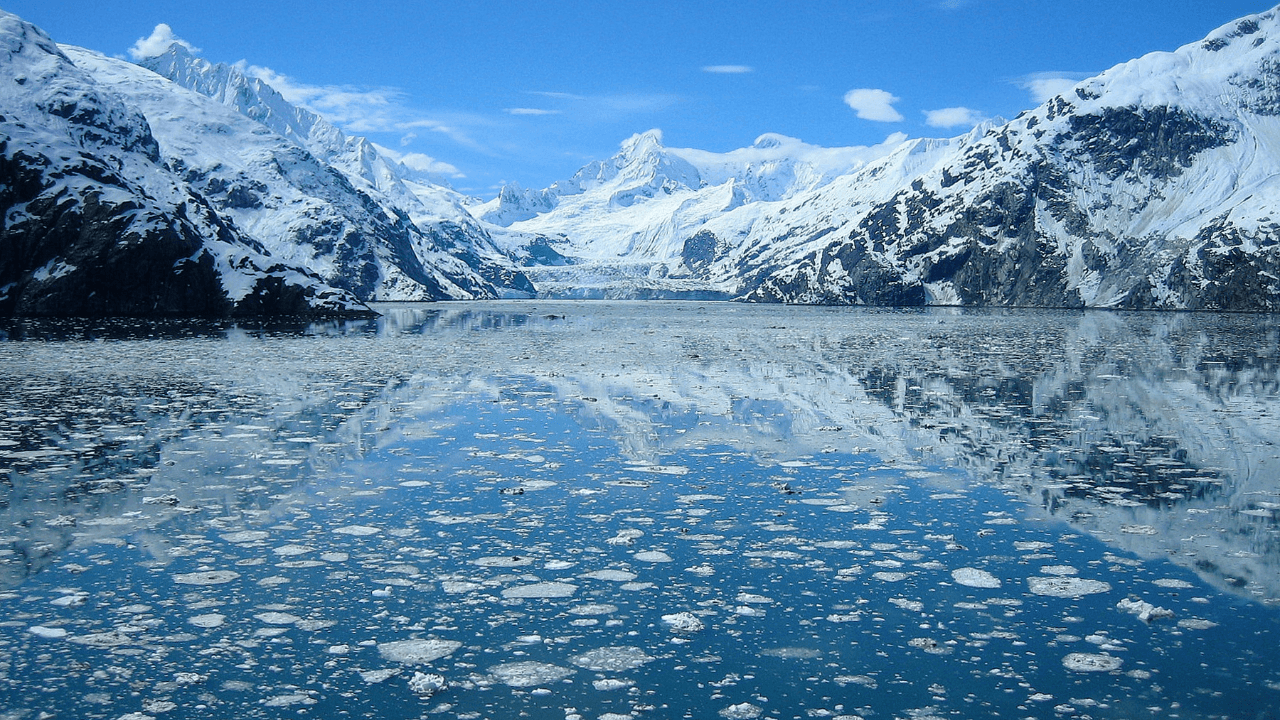
Few treks in the Indian Himalaya carry the weight of history quite like the Milam Glacier trek. For centuries, Bhotiya traders hauled salt, wool, and grain along this very corridor — a branch of the ancient Silk Route threading through the Kumaon Himalayas into Tibet. Today, the trail is one of Uttarakhand's best-kept secrets: a 9-day wilderness journey up the Gori Ganga valley that ends at the snout of the Milam Glacier, sitting at approximately 3,870 m above sea level, with the sheer faces of Nanda Devi East (7,434 m), Hardeol (7,151 m), and Trishuli (7,074 m) filling the skyline above.
Located in Pithoragarh district, the route passes through the buffer zone of the Nanda Devi Biosphere Reserve and brushes close to the Indo-Tibet border — which is precisely why it requires an Inner Line Permit (ILP) and why it has stayed refreshingly off the mass-trekking radar. If you are looking for an alternative to the crowded trails of Kedarkantha or Roopkund, the Milam Glacier trek in the 2026 season rewards the extra logistical effort with solitude, cultural depth, and mountain scenery that few routes in India can match.
Panoramas That Stop You in Your Tracks
The views on this trek are extraordinary even by Himalayan standards. On clear days from Milam Village and the glacier snout, you can see Nanda Devi East (the eastern satellite peak of India's second-highest mountain), Hardeol, Trishuli Peak, and the glaciated ridgelines of the Milam Himal stretching toward Tibet. These are not distant silhouettes — they are close, overwhelming, and completely unobstructed.
Remote and Genuinely Undiscovered
While treks like Pindari Glacier (compare here) and Valley of Flowers attract thousands of visitors each season, Milam sees a fraction of that footfall. The trail has no tea-stall culture, no crowded campsites, and no souvenir vendors. That remoteness is the point.
Living Bhotiya Heritage
Milam Village is one of the highest permanently inhabited settlements in Uttarakhand, home to the Bhotiya community — a Trans-Himalayan people whose ancestral trade with Tibet was severed in 1962 after the Sino-Indian war. Walking through Milam is walking through a frozen chapter of border history. Many families now welcome trekkers into their stone-and-wood homes as homestay guests.
The Indo-Tibet Border Edge
The trail's proximity to a sensitive international frontier adds a palpable sense of remoteness and adventure. The military presence at checkposts is a reminder that you are entering a zone few outsiders ever reach.
How Does Milam Compare to Other Uttarakhand Glacial Treks?
Compared to the Nanda Devi Sanctuary Trek (which has stricter access) or the popular Ralam Glacier Trek (a shorter neighbouring route), Milam strikes a rare balance of accessibility and raw wilderness. It is part of the broader Munsiyari trekking circuit and deserves far more attention than it gets.
Milam Glacier Trek at a Glance
| Feature | Details |
|---|---|
| Total Distance | ~60 km one way (~120 km round trip) |
| Maximum Altitude | ~3,870 m (Milam Glacier snout) |
| Duration | 7–10 days (9-day itinerary recommended) |
| Base Town | Munsiyari, Pithoragarh district |
| Difficulty | Moderate–Difficult |
| Best Season | May–June; September–mid-October |
| Permit Required | Yes — Inner Line Permit (ILP) |
| Trek Type | Out-and-back |
| Nearest Railhead | Kathgodam (~275 km) |
At a glance
Ask TrekSage about Milam Glacier Trek
Get instant answers grounded in verified trek data — beginner-friendliness, best months, permits, packing, and more.
The route at a glance
The trek follows a single linear valley — the Gori Ganga river gorge — northward from Munsiyari to the glacier, making navigation straightforward but the terrain anything but. The Gori Ganga is crossed multiple times on suspension bridges and stepping-stone fords, and the trail alternates between dense oak-rhododendron forest, open moraines, alpine meadows, and boulder fields.
Munsiyari → Lilam → Bogudiyar → Ganghar → Rilkot → Burphu → Milam Village → Milam Glacier
Munsiyari (2,200 m) is the sole practical starting point. There is no alternate trailhead — the jeep track ends here and the restricted zone begins shortly beyond Lilam checkpost. The trail initially descends from Munsiyari toward the Gori Ganga before gradually climbing through a series of small settlements and river crossings over the course of five days to reach Milam Village at 3,450 m.
Key landmarks include the dramatic gorge section between Lilam and Bogudiyar, the ruins of Ganghar (a settlement abandoned after a catastrophic landslide), the military outpost village of Burphu, and finally Milam — a ghost-town-like spread of stone houses that springs to life each summer when families return from lower-altitude winter homes.
Elevation Profile and Key Landmarks
| Stage | Altitude | Notes |
|---|---|---|
| Munsiyari | 2,200 m | Base town; start/end of trek |
| Lilam | ~1,800 m | First camp; ILP checkpost; note descent from Munsiyari |
| Bogudiyar | ~2,270 m | Road-end village; last motorable point |
| Ganghar | ~2,600 m | Largely abandoned; river crossing nearby |
| Rilkot | ~3,000 m | Forest rest house; good campsite |
| Burphu | ~3,200 m | Last village before Milam; army presence |
| Milam Village | ~3,450 m | Highest major camp; Bhotiya homestays |
| Milam Glacier Snout | ~3,870 m | Day-hike destination; return to Milam |
Note: The initial descent from Munsiyari to Lilam (~400 m drop) surprises many trekkers who expect constant climbing. The altitude is then recovered gradually over the next four days. This profile means the first day feels deceptively easy — do not rush.
Nearest Railhead: Kathgodam (approximately 275 km from Munsiyari). Kathgodam is well-connected to Delhi and other major cities by train.
By Road from Kathgodam:
- Shared jeep: Available from Kathgodam bus stand via Almora and Pithoragarh to Munsiyari. Fare approximately ₹600–₹1,200 per seat (⚠️ verify current fares). Journey time: 10–12 hours.
- Private taxi: ₹4,000–₹7,000 for the full vehicle (⚠️ verify current fares). More comfortable for groups.
- There is no direct bus service to Munsiyari from major cities. State buses from Pithoragarh to Munsiyari are available but infrequent.
Nearest Airport: Pantnagar Airport (approximately 280 km from Munsiyari). Flights connect Pantnagar to Delhi. From Pantnagar, hire a private taxi to Munsiyari.
Recommended: Break the road journey with an overnight halt in Almora or Pithoragarh to reduce fatigue and start the trek fresher. See our Munsiyari travel guide for accommodation recommendations.
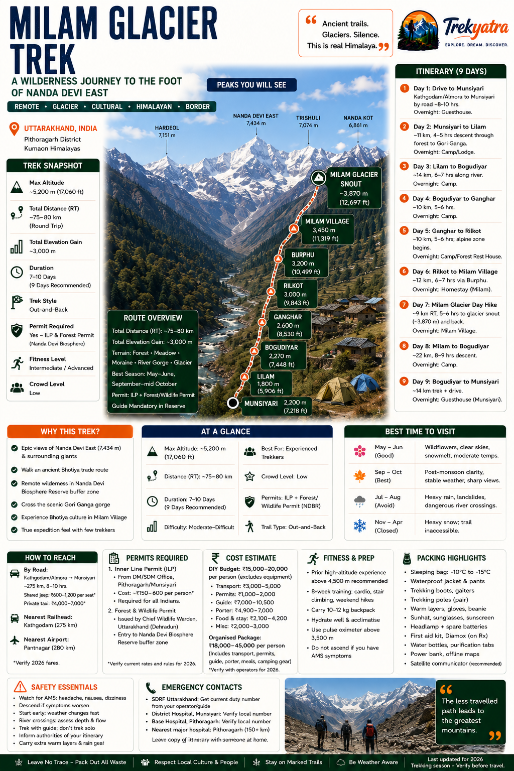
What each day actually looks like
Day 1: Drive — Kathgodam/Haldwani to Munsiyari
Distance: ~275 km by road | Duration: 10–12 hours | Altitude: Arrive at 2,200 m
Most trekkers catch an overnight train to Kathgodam (the nearest railhead) and begin the road journey early morning. The route passes through Almora and Pithoragarh before climbing steeply to Munsiyari. The drive is scenic but long — Birthi Falls is a worthwhile short stop. Arrive in Munsiyari by evening; collect your ILP if not arranged in advance. Stay: Hotel or guesthouse in Munsiyari (₹500–₹1,500/night).
Day 2: Munsiyari to Lilam
Distance: ~11 km | Altitude: 2,200 m → 1,800 m (descent) | Walking time: 4–5 hours
The trail drops through forests of oak and rhododendron toward the Gori Ganga. Lilam is a small hamlet with a forest checkpost where your ILP is verified. This is the point of no return if your permit is not in order. Stay: Basic guesthouse or camping at Lilam.
Day 3: Lilam to Bogudiyar
Distance: ~14 km | Altitude: 1,800 m → 2,270 m | Walking time: 6–7 hours
A long riverside walk with multiple trail sections cut into cliff faces above the Gori Ganga gorge. The scenery turns dramatic as the valley narrows. Bogudiyar is the last point reachable by jeep track (from the Munsiyari side) and usually has a small dhaba open in season. Stay: Camping or basic accommodation at Bogudiyar.
Day 4: Bogudiyar to Ganghar
Distance: ~10 km | Altitude: 2,270 m → 2,600 m | Walking time: 5–6 hours
The trail climbs steadily past waterfalls and through mixed forest. Ganghar is a largely deserted settlement — a sobering reminder of the landslide that displaced its residents. The meadows here make for a beautiful campsite. Stay: Camping at Ganghar.
Day 5: Ganghar to Rilkot
Distance: ~10 km | Altitude: 2,600 m → 3,000 m | Walking time: 5–6 hours
Altitude begins to make itself felt. The trail opens up into wider valley views and the first distant glacier glimpses appear. Rilkot has a PWD/forest rest house (booking advisable) and flat camping ground. Stay: Forest rest house or camping at Rilkot.
Day 6: Rilkot to Milam Village
Distance: ~12 km | Altitude: 3,000 m → 3,450 m | Walking time: 6–7 hours
Pass through Burphu (3,200 m), a small inhabited village with an army post — carry your ILP for inspection. The final stretch to Milam Village crosses alpine terrain with widening views of Hardeol and Trishuli. Milam Village itself is extraordinary — rows of stone houses, a small temple, and welcoming Bhotiya families. Stay: Homestay in Milam Village (₹300–₹600/night including meals) — strongly recommended for cultural experience.
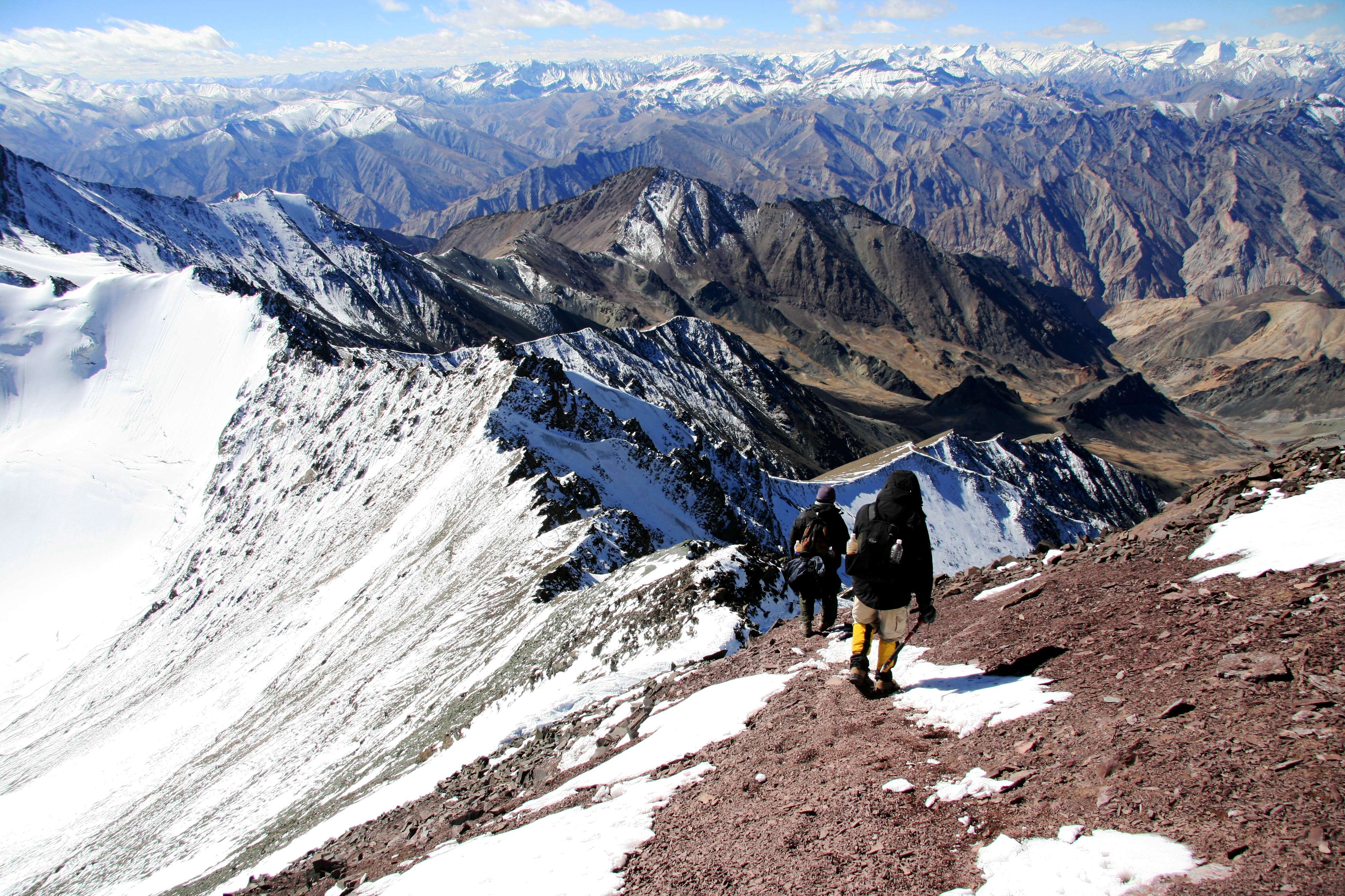
Day 7: Milam Village to Milam Glacier Snout and Return
Distance: ~9 km round trip | Altitude: 3,450 m → 3,870 m and back | Walking time: 5–6 hours
The highlight of the entire trek. The trail from Milam Village to the glacier snout crosses moraines and boulder fields. The snout itself is a dramatic chaos of ice, meltwater streams, and terminal moraine. Nanda Devi East dominates the head of the valley. Return to Milam Village by afternoon. Stay: Milam Village (second night).
Day 8: Milam Village to Bogudiyar
Distance: ~22 km | Altitude: 3,450 m → 2,270 m | Walking time: 8–9 hours
A long descent day — start early. The downhill is easier on lungs but demanding on knees; trekking poles are essential. You can split this into two days (stopping at Rilkot or Ganghar) if time allows. Stay: Bogudiyar.
Day 9: Bogudiyar to Munsiyari (Drive/Trek) and Departure
Distance: Trek ~14 km to Lilam then drive, or jeep from Bogudiyar | Duration: Half day trek + drive
Return to Munsiyari by afternoon. Freshen up, debrief with your guide, and begin the road journey back toward Kathgodam or stay an extra night in Munsiyari to visit Khaliya Top.
Acclimatisation and Rest Day Options
An optional rest day at Milam Village (between Days 6 and 7) is highly recommended for trekkers who feel any symptom of altitude sickness. Use it for a short acclimatisation hike toward Burphu viewpoint or the ridgeline north of the village — gain altitude, return lower to sleep.
Signs of AMS to watch for: persistent headache not relieved by paracetamol, nausea or vomiting, loss of coordination, confusion, and breathlessness at rest. If two or more symptoms appear, descend immediately — do not wait for morning. See our detailed altitude sickness prevention guide for Diamox dosage protocol.
When to go
Pre-Monsoon: May–June (Recommended)
This is the most popular window for the 2026 season. Skies are generally clear, wildflowers carpet the valley slopes, and snowmelt adds drama to the Gori Ganga crossings without making them dangerous. Expect cold nights at Milam (sub-zero) but comfortable daytime temperatures. Rhododendrons peak in mid-May at lower elevations.
Monsoon: July–August (NOT Recommended)
Heavy rainfall triggers landslides on the cliff-side trail sections between Lilam and Bogudiyar. The Gori Ganga swells to levels that make river crossings genuinely dangerous. Several years have seen the trail blocked for days. Avoid this window.
Post-Monsoon: September–mid-October (Recommended)
Many experienced trekkers prefer this window. The monsoon washes the sky clean, yielding the sharpest mountain views of the year. The Gori Ganga returns to safe levels, autumn foliage turns the valley gold and red, and trail conditions are dry and stable. Temperatures drop sharply after mid-October.
Winter: November–April (Inaccessible)
Heavy snowfall blocks the trail beyond Munsiyari from November onward. The road to Munsiyari itself can become treacherous. The glacier snout is buried under several metres of snow. Do not attempt this trek in winter without specialist mountaineering skills and equipment.
Is this trek right for you?
The Milam Glacier trek is graded Moderate–Difficult. Here is why the upper end of that range matters:
- Daily distances: 10–22 km depending on the day, on uneven rocky trail
- Cumulative elevation gain: approximately 2,500–3,000 m over the ascent days
- Trail quality: No paved sections; significant stretches across loose moraine and cliff-cut paths
- Rescue infrastructure: Essentially zero beyond Munsiyari. The nearest hospital with meaningful facilities is in Pithoragarh, 150+ km away
- Altitude: While 3,870 m is not extreme, the combination of altitude, remoteness, and daily effort demands respect
Recommended fitness baseline:
- Ability to walk 15 km/day on uneven terrain with a 10–12 kg pack
- Prior Himalayan trekking experience strongly preferred (at minimum, a moderate-altitude trek above 3,000 m)
- Not suitable for first-time Himalayan trekkers with zero altitude experience
Training (8 weeks prior):
- 3–4 cardio sessions/week (running, cycling, swimming)
- Stair climbing with a loaded daypack
- 15–20 km weekend hikes on uneven terrain
- Core and leg strengthening exercises
For Uttarakhand treks of similar grade, building up with a shorter route like Pindari Glacier first is advisable.
What permits you need
This is the most critical logistical step for the Milam Glacier trek — do not skip it.
Inner Line Permit (ILP)
Because the trail passes through a sensitive zone close to the Indo-Tibet border, all trekkers require an Inner Line Permit (ILP). This is a government-issued document controlling entry into protected border areas of Uttarakhand.
Issuing Authority:
- District Magistrate (DM) office, Pithoragarh
- Sub-Divisional Magistrate (SDM) office, Munsiyari (recommended — faster for trekkers already in Munsiyari)
Cost: Approximately ₹150–₹600 per person (⚠️ Verify 2026 rates with DM Pithoragarh or SDM Munsiyari before travel)
Documents Required:
- 2 passport-size photographs
- Copy of Aadhaar card (Indian nationals) or passport (foreign nationals)
- Filled application form (available at the issuing office)
Processing Time: Same-day in most cases at SDM Munsiyari; up to 2 days at DM Pithoragarh
For Foreign Nationals: ⚠️ Historically, this route has been restricted to Indian nationals only due to its proximity to the international border. Foreign trekkers must check the current 2026 regulations with the DM Pithoragarh office directly before planning travel. Rules have changed in the past and may change again.
Nanda Devi Biosphere Reserve Entry: An additional forest department entry fee may apply for the buffer zone sections of the trail. ⚠️ Confirm applicability and 2026 fee at the Munsiyari forest office.
Critical: Your ILP will be checked at the Lilam checkpost. Trekkers without a valid permit are turned back here, no exceptions.
See our full Inner Line Permit guide for Uttarakhand for a step-by-step walkthrough.
What this trek will cost you
DIY Trek — Per Person Cost Breakdown (9 Days)
| Item | Estimated Cost (INR) |
|---|---|
| Kathgodam → Munsiyari (shared jeep) | ₹1,200–₹1,800 |
| Accommodation in Munsiyari (2 nights) | ₹1,000–₹3,000 |
| ILP permit | ₹200–₹600 |
| Porter (7 days × ₹700–₹1,000/day) | ₹4,900–₹7,000 |
| Guide (7 days × ₹1,000–₹1,500/day) | ₹7,000–₹10,500 |
| Homestays/camping on trail (7 nights) | ₹2,100–₹4,200 |
| Meals on trail (included in most homestays) | ₹0–₹1,500 |
| Miscellaneous (tips, forest fees, etc.) | ₹500–₹1,000 |
| DIY Total Estimate | ₹8,000–₹14,000 |
Excludes: travel to/from Kathgodam, equipment rental, personal gear
⚠️ Costs are estimates based on regional benchmarks; verify current rates with local operators in Munsiyari. Costs have risen across Uttarakhand trekking in recent years.
Note on Porters: Porters are practically mandatory for the glacier section and strongly recommended throughout. The trail is remote enough that carrying a heavy pack yourself while managing altitude and river crossings significantly increases risk.
Organised Package — Per Person
| Package Type | Cost Range (INR) |
|---|---|
| Budget group package (6–8 pax) | ₹18,000–₹22,000 |
| Standard package (guide, porter, transport from Kathgodam, permits, accommodation) | ₹22,000–₹28,000 |
| Premium/small-group package | ₹28,000–₹35,000 |
Organised packages typically include transport from Kathgodam, all permits, guide, porters, meals on trail, and tent accommodation where homestays are unavailable.
What to pack
Clothing
- Moisture-wicking base layers (2 sets)
- Fleece mid-layer jacket
- Waterproof, windproof outer shell (essential for glacier section)
- Thermal innerwear top and bottom
- Trekking pants (2 pairs; one convertible)
- Warm beanie/wool hat
- Sun hat with wide brim
- Lightweight gloves + heavier insulated gloves for glacier day
- Neck gaiter or balaclava
- Woollen socks (4–5 pairs; merino recommended)
Footwear
- Sturdy waterproof trekking boots (broken in before the trek) — see our best trekking boots guide
- Gaiters (for snow and mud on glacier section)
- Camp sandals or lightweight shoes (for evenings)
Gear
- 50–60 L backpack with rain cover — see trekking backpack guide
- Sleeping bag rated to -10°C
- Trekking poles (pair; collapsible)
- Headlamp with spare batteries
- Dry bags/stuff sacks for electronics and documents
- Water bottles (2 × 1L) or hydration bladder
Safety & Health
- Personal first aid kit (blister pads, bandages, antiseptic, pain relief)
- Diamox (acetazolamide) — consult your doctor before travel
- ORS sachets (minimum 10)
- Sunscreen SPF 50+
- UV-protection lip balm
- Water purification tablets or filter
- Insect repellent
Documents
- ILP permit (carry 2 photocopies)
- Government-issued ID proof (original + copy)
- Emergency contact sheet (laminated)
- Travel insurance documents
Electronics
- Power bank (20,000 mAh minimum — no charging on trail)
- Offline maps downloaded on phone (Maps.me, Gaia GPS)
- Camera with spare batteries (cold kills battery life rapidly)
- Satellite communicator (SPOT/Garmin inReach — strongly recommended given no mobile coverage)
Staying safe on the mountain
Altitude & AMS
Do not ascend more than 300–500 m per day above 2,500 m. Carry Diamox (125–250 mg twice daily) as a preventive measure if advised by your doctor. The moment two or more AMS symptoms appear — descend. There is no shame and potentially no alternative.
River Crossings
The Gori Ganga crossings are on suspension bridges or stepping stones. After heavy rain, water levels rise rapidly. Never attempt a ford if the water looks waist-high or faster than walking pace. Wait for the level to drop or turn back.
Mobile Network
BSNL has intermittent signal in Munsiyari and occasionally at Bogudiyar. Beyond that, assume zero coverage. Carry a satellite communicator (Garmin inReach or SPOT device) for emergencies — this is not optional on a remote trek like Milam.
Nearest Hospital
Pithoragarh District Hospital is 150+ km from the trailhead. Evacuation by foot and road in an emergency would take many hours. This underscores why fitness, experience, a guide, and a satellite communicator are non-negotiable.
Register Your Trek
Before departure from Munsiyari, register your trek details (route, expected return date, emergency contacts) with the local police station or the SDM office. This is free and could save your life.
Never Trek Solo
The Milam trail is remote, poorly marked in sections, and subject to rapid weather changes. Always trek with at least one other person and preferably with a local guide.
Weather Turnaround Protocol
If clouds build rapidly, visibility drops, or thunder is heard, descend to the nearest safe camp immediately. High-altitude weather can shift from clear to dangerous in under 30 minutes.
Glacier Etiquette and Safety
Near the glacier snout, avoid walking on unstable moraine edges and keep well away from crevasse areas. Do not venture onto the glacier surface without crampons and a guide experienced in glacier travel. The snout viewpoint is accessible and rewarding without stepping onto the ice itself.
Similar treks to explore
Nubra Valley Trek: Routes, Permits & Best Time (2026)
The Nubra Valley trek is a 65–90 km high-altitude route in Ladakh crossing Khardung La (5,359 m) into a cold-desert valley at 3,048 m, completed in 7 days.
Sham Valley Trek: Complete Beginner's Guide (2026)
The Sham Valley Trek is Ladakh's most beginner-friendly high-altitude trek, reaching a maximum of ~3,700m over 4–5 days.
Stok Kangri Trek: Complete Guide for Climbers
The Stok Kangri trek is a high-altitude mountaineering route in Ladakh, India, reaching a summit of 6,153 metres — one of India's most accessible 6,000m+ peaks.
Common questions answered
Yes — an Inner Line Permit (ILP) is mandatory for all trekkers on this route due to its proximity to the Indo-Tibet border. The permit is issued by the District Magistrate (DM) office in Pithoragarh or the SDM office in Munsiyari (faster option). You will need passport-size photographs and a copy of your Aadhaar card (Indian nationals) or passport. The approximate cost is ₹150–₹600 per person (⚠️ verify 2026 rates). Your permit will be checked at the Lilam checkpost — entry is denied without it. Foreign nationals should separately verify whether they are currently permitted on this route; historically, it has been restricted to Indian citizens.
Live Conditions
Real-time weather & trail status
Trail Conditions
Crowdsourced reports from trekkers who've done this route
Sign in to add a trip report
Find a Trek Buddy
Connect with trekkers planning the same route
No buddies yet for this trek
Sign in and be the first to post a planning signal.