Why Nanda Devi East Base Camp Trek is on every trekker's list
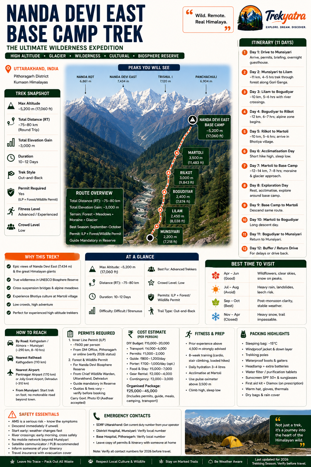
The Nanda Devi East Base Camp trek is a 10–12 day, 75–80 km round-trip wilderness trek from Munsiyari to ~5,200 m in Uttarakhand's Pithoragarh district, rated Difficult.
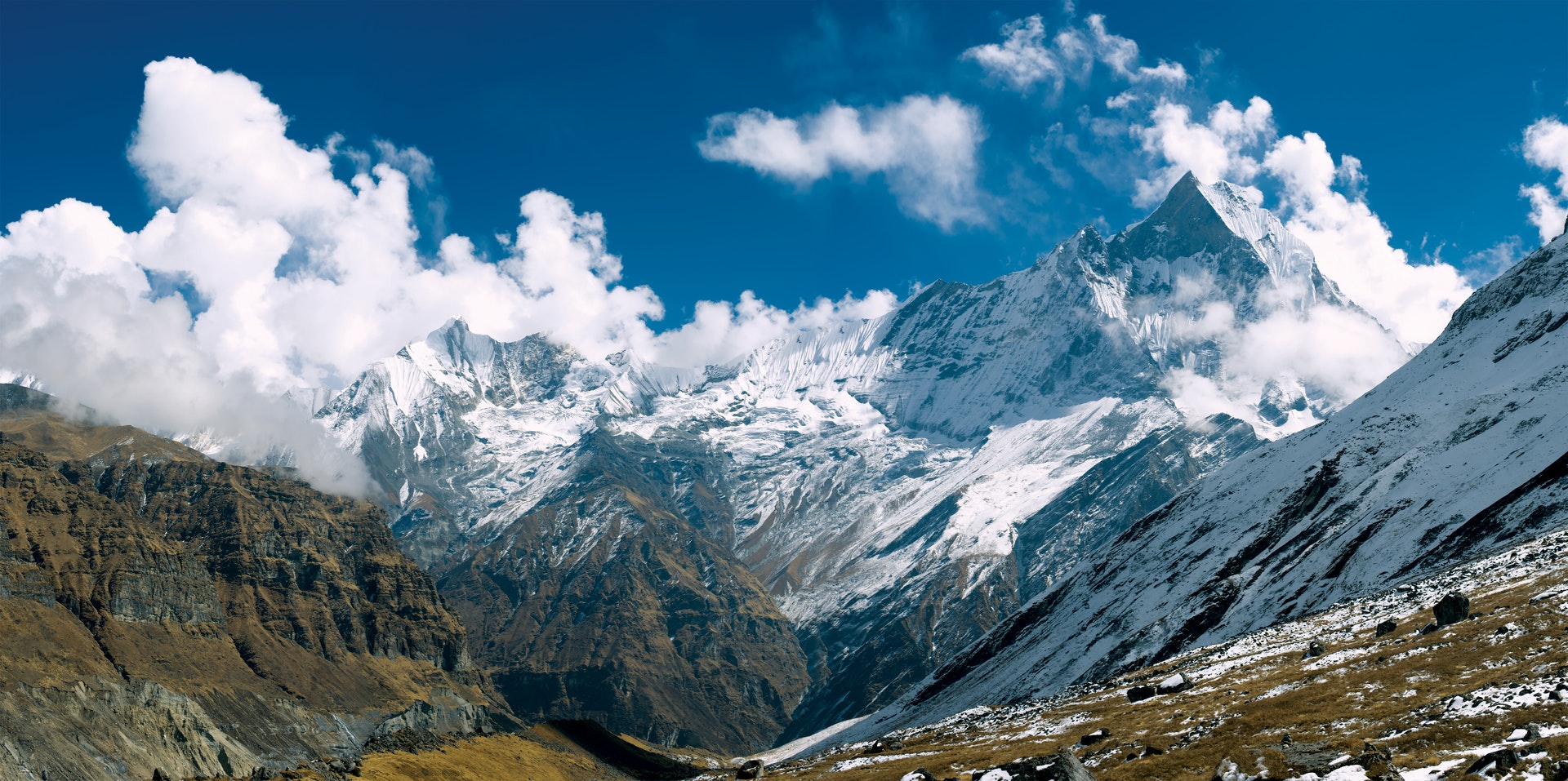
Deep in the Pithoragarh district of Uttarakhand, where the Gori Ganga carves a jade corridor through the Kumaon Himalayas, lies one of India's least-visited and most spectacular trekking destinations: the Nanda Devi East Base Camp. Sitting at approximately 5,200 m (17,060 ft) beneath the savage south face of Nanda Devi East (7,434 m), this is not a trek for the faint-hearted — nor for anyone seeking a crowded trail.
The route falls within the Nanda Devi Biosphere Reserve, a UNESCO-recognised wilderness that shelters snow leopards, Himalayan black bears, and ancient forests of birch and rhododendron. Unlike the more talked-about Nanda Devi main (west) base camp approach from Lata village in Chamoli district — which has faced access restrictions for decades — the eastern approach via Munsiyari remains accessible under strict permit conditions, offering a genuine expedition-style adventure that most Indian trekkers have never heard of.
What sets the eastern route apart? Fewer trekkers, wilder terrain, the cultural richness of Bhotiya villages like Martoli and Milam, and a glacial landscape that feels genuinely untamed. If you have high-altitude experience and a hunger for real wilderness, the 2026 trekking season on this route deserves your full attention.
In an era when popular Himalayan trails are beginning to feel like queues, the Nanda Devi East approach remains gloriously uncrowded. The reasons are straightforward: the permit process is more involved, the terrain is tougher, and the logistics require more planning. That is precisely the point.
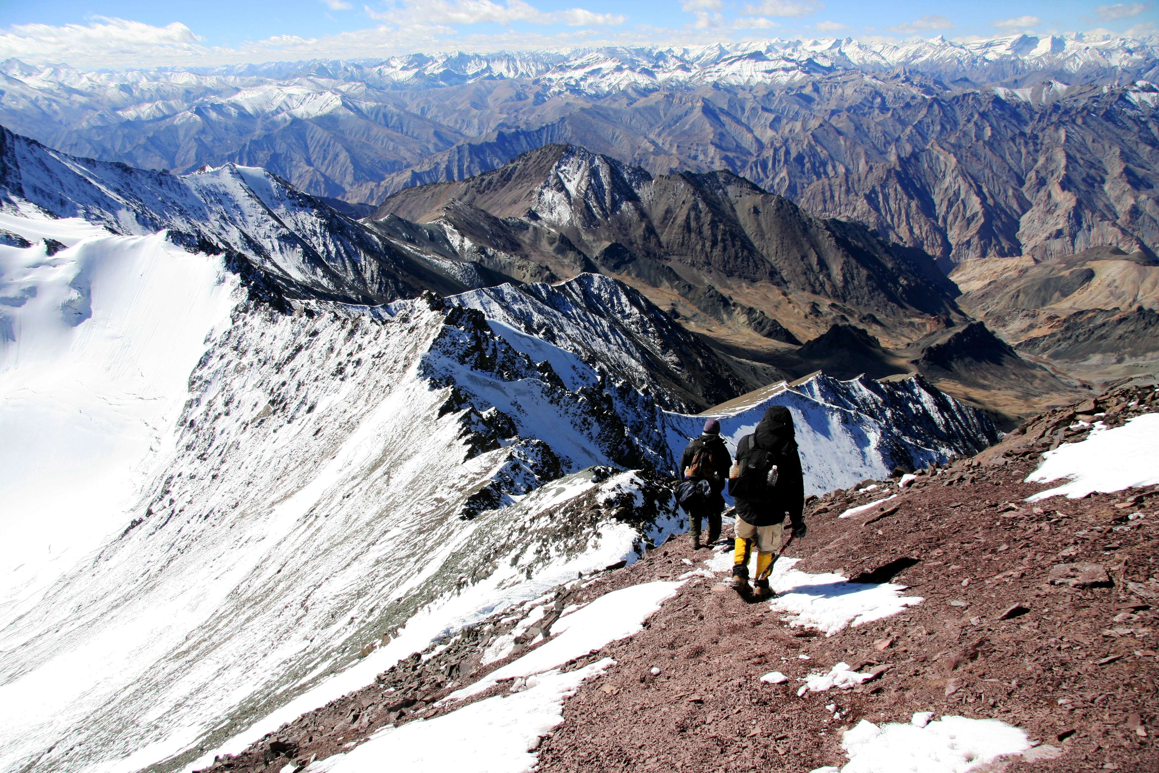
Raw, undiluted wilderness. The Gori Ganga Valley between Munsiyari and Martoli is a world unto itself — dense forests, river-sculpted gorges, suspension bridges, and meadows carpeted with Himalayan wildflowers in May and June. By the time you reach the moraines approaching base camp, the scale of the surrounding peaks is humbling.
Iconic mountain views. From the base camp and surrounding ridges you can look up at Nanda Devi East (7,434 m), across to Nanda Kot (6,861 m), and over the watershed toward Panwali Dwar. These are serious Himalayan giants, and viewing them from a true wilderness base camp — without another trekking group in sight — is a rare privilege.
Cultural depth. The trail passes through villages settled by the Bhotiya community, a trans-Himalayan trading people whose traditional route to Tibet followed this very valley. Martoli, once a thriving trade village, is one of the most evocative abandoned settlements in the Indian Himalayas. Speaking with the families who still summer here adds a human dimension that purely glacial treks often lack.
Expedition character. There are no tea-house trails here. You camp, you carry, you commit. For trekkers looking to bridge the gap between standard trekking and mountaineering expeditions, this route is an ideal proving ground.
Internal link: Considering other wild routes in the region? See our Milam Glacier Trek guide and Munsiyari Trekking Guide.
At a glance
Ask TrekSage about Nanda Devi East Base Camp Trek
Get instant answers grounded in verified trek data — beginner-friendliness, best months, permits, packing, and more.
The route at a glance
The standard route follows the Gori Ganga Valley northward from Munsiyari, ascending through progressively remote terrain before reaching the glacial amphitheatre below Nanda Devi East. The total round-trip distance is approximately 75–80 km, with the trail gaining around 3,000 m of net elevation from Munsiyari's roadhead at 2,200 m to base camp at ~5,200 m.
The trail in brief:
- Munsiyari (2,200 m): The last major town and logistics hub. Stock up on supplies, confirm permits, and brief your guide.
- Lilam (2,450 m): A small settlement at the valley entrance, approximately 11 km from Munsiyari. The trail hugs the Gori Ganga through dense mixed forest.
- Bogudiyar (2,400 m): A slight descent from Lilam before the valley begins its real climb. River crossings begin in earnest here.
- Rilkot (3,000 m): The forest opens into scrub and alpine meadow. Views of the surrounding ridgelines begin to appear.
- Martoli (3,500 m): The last significant settlement — and the emotional heart of the trek. An acclimatisation rest day here is non-negotiable.
- Nanda Devi East Base Camp (~5,200 m): A stark, morainic landscape beneath the peak's glaciated flanks. The Milam Glacier system is visible to the east.
River crossings and technical terrain: Several unbridged crossings exist between Bogudiyar and Rilkot; conditions are most challenging during snowmelt (May–June) and monsoon. The approach to base camp involves moraine scrambling and a short glacier-edge walk requiring good footing and trekking poles.
Digital route: A GPX file for this route is available through the Uttarakhand Tourism portal and select trekking operators. We recommend downloading and loading it to a GPS device or offline-capable app (such as OsmAnd or Gaia GPS) before departure. Do not rely solely on cellular signal, which is absent for most of the route above Munsiyari.
Internal link: For a broader overview of high-altitude routes in the state, visit our Uttarakhand High-Altitude Treks hub.
Elevation Profile & Key Waypoints
| Waypoint | Altitude | Notes |
|---|---|---|
| Munsiyari | 2,200 m (7,218 ft) | Roadhead; permits, supplies |
| Lilam | 2,450 m (8,038 ft) | Forest trail along Gori Ganga |
| Bogudiyar | 2,400 m (7,874 ft) | Slight descent; river crossings begin |
| Rilkot | 3,000 m (9,843 ft) | Alpine zone begins |
| Martoli | 3,500 m (11,483 ft) | Acclimatisation camp; Bhotiya village |
| Nanda Devi East Base Camp | ~5,200 m (17,060 ft) | Glacial moraine; expedition-style camp |
Net altitude gain (Munsiyari to Base Camp): ~3,000 m over approximately 37–40 km one way.
What each day actually looks like
The following is an indicative 11-day itinerary. Your registered guide may adjust daily stages based on group fitness, weather, and permit conditions.
Day 1 — Drive to Munsiyari
Kathgodam or Almora → Munsiyari by road (~8–10 hours). Arrive, check into guesthouse, confirm permit documents, and meet your local guide. Overnight: guesthouse, Munsiyari.
Day 2 — Munsiyari to Lilam (~11 km, 4–5 hrs)
Descend to the Gori Ganga and follow the river trail through dense oak and rhododendron forest. The path is well-defined but rocky in sections. Overnight: tent camp or basic rest house at Lilam.
Day 3 — Lilam to Bogudiyar (~10 km, 5–6 hrs)
The valley narrows and the trail crosses several tributary streams. The route dips slightly in elevation before Bogudiyar. Look out for langur monkeys and Himalayan birds. Overnight: tent camp, Bogudiyar.
Day 4 — Bogudiyar to Rilkot (~12 km, 6–7 hrs)
A longer day with more significant elevation gain. The forest thins and views of snow-dusted ridgelines appear. River crossings require care. Overnight: tent camp, Rilkot.
Day 5 — Rilkot to Martoli (~10 km, 5–6 hrs)
The trail enters true alpine terrain. Martoli's stone ruins and remaining inhabited structures come into view. Short day to allow rest and acclimatisation. Overnight: tent camp or seasonal homestay, Martoli.
Day 6 — Acclimatisation Day at Martoli
Do not ascend. Take a short hike to a nearby ridge (3,800–4,000 m) for views, then return to Martoli to sleep low. Monitor for AMS symptoms. (See section below.) Overnight: tent camp, Martoli.
Day 7 — Martoli to Nanda Devi East Base Camp (~12–14 km, 7–8 hrs)
A demanding day across alpine meadow, moraine, and glacier-edge terrain. The final 3–4 km are on unstable rock; trekking poles essential. First views of the base camp cirque are staggering. Overnight: high-altitude tent camp, ~5,200 m.
Day 8 — Exploration Day at Base Camp
Explore the moraine, photograph the peak faces, look for wildlife. Do not ascend further without a qualified mountaineer and additional permits. Rest, hydrate, and prepare for descent. Overnight: tent camp, base camp.
Day 9 — Base Camp to Martoli
Reverse Day 7 trail. Descend carefully on moraine sections. Overnight: tent camp, Martoli.
Day 10 — Martoli to Bogudiyar
Reverse Days 4–5. Longer descent day; knees will feel it. Trekking poles recommended throughout. Overnight: tent camp, Bogudiyar.
Day 11 — Bogudiyar to Munsiyari
Final long day combining the Lilam and Munsiyari stages if fitness allows, or split across two days using the buffer. Overnight: guesthouse, Munsiyari.
Day 12 (Buffer/Return): Drive back toward Kathgodam or onward travel. Use this day for any weather delays experienced earlier in the trek.
Acclimatisation & Rest Days: How Do You Avoid AMS on This Trek?
The rest day at Martoli (3,500 m) is not optional — it is the cornerstone of this trek's safety architecture. The jump from Rilkot to the eventual base camp altitude of 5,200 m is aggressive, and without adequate time at intermediate elevation, the risk of Acute Mountain Sickness (AMS) rises sharply.
Recognise AMS early: Persistent headache, nausea, loss of appetite, fatigue disproportionate to exertion, disturbed sleep, and dizziness are warning signs. Do not ascend if any of these are present. Descend immediately if symptoms worsen or if a trekker shows signs of HACE (confusion, ataxia) or HAPE (breathlessness at rest, gurgling cough).
The golden rule: Climb high, sleep low. Use your Martoli rest day to hike 300–400 m higher, then return to camp. This stimulates red blood cell production without the sustained stress of sleeping at altitude. Above 3,500 m, limit altitude gain to ~300–500 m per sleeping night.
Internal link: Read our detailed Altitude Sickness Prevention guide before departure.
When to go
May–June (Pre-monsoon): Trails are accessible from mid-May. Wildflowers — primula, potentilla, and Himalayan blue poppy — cover the meadows. Visibility is generally good, though afternoon clouds build frequently. River crossings are at their most challenging due to snowmelt volume. A solid second choice.
July–August (Monsoon — NOT recommended): The Gori Ganga Valley receives significant monsoon rainfall. Trails become treacherous with landslides, rock falls, and flooded river crossings. Leeches infest the lower forest sections. Most experienced operators suspend departures during this period.
September–October (Post-monsoon — Best season): This is the single best window. The monsoon retreats by early September, leaving skies washed crystal clear. Views of Nanda Devi East, Nanda Kot, and the surrounding massifs are at their sharpest. Temperatures are cold but stable; expect sub-zero nights at base camp but comfortable days. October closes quickly — snow can arrive above 4,000 m by late October.
September is the optimal month for this trek in 2026. Book permits and operators by July to secure your slot within the group-size quota.
November–April (Closed): Heavy snowfall renders the trail above Martoli impassable. The route is effectively closed from November through April.
Is this trek right for you?
Grade: Difficult / Strenuous
This trek is suitable only for trekkers with prior high-altitude experience above 4,500 m. If your highest previous camp has been below this threshold, consider completing the Pindari Glacier Trek or a similar Kumaon route first.
Daily walking: 6–8 hours on most stages, with the base camp approach day stretching to 8+ hours.
Technical challenges:
- Unbridged river crossings with significant flow (especially May–June)
- Moraine scrambling requiring balance and sure-footedness
- Glacier-edge approach with loose rock
- Sustained high altitude above 4,500 m for 2–3 consecutive days
Recommended 8-week training plan:
- Weeks 1–2: Daily 45-minute brisk walks; build to jogging 30 minutes 4x/week
- Weeks 3–4: Introduce stair climbing (15–20 floors daily); add loaded backpack walks (8–10 kg)
- Weeks 5–6: Weekend hikes of 4–6 hours; increase backpack weight to 12–15 kg
- Weeks 7–8: Full-day hikes on consecutive days to simulate trail conditions; focus on descents to protect knees
Not suitable for: Complete beginners, individuals with untreated cardiac or respiratory conditions, or those who have not trekked above 3,500 m previously.
What permits you need
This is one of the most regulation-intensive treks in Uttarakhand. Read this section carefully and verify all details with the relevant authorities before booking, as rules can change between trekking seasons.
1. Inner Line Permit (ILP)
Pithoragarh district shares a border with Nepal and China, making it a restricted area under the Inner Line regulations. All Indian nationals must carry a valid ILP; foreign nationals require additional clearance.
- Cost: Approximately ₹600 per person (flag for 2026 verification — fee structure subject to change)
- Where to obtain: District Magistrate (DM) office, Pithoragarh; also available through select Uttarakhand government online portals. Check the official Uttarakhand e-district portal for current online application status.
- Processing time: 1–2 working days in person; allow more time for online applications.
2. Nanda Devi Biosphere Reserve / Wildlife Permit
Entry into the buffer and restricted zones of the Nanda Devi Biosphere Reserve requires a separate forest and wildlife permit issued by the Chief Wildlife Warden, Uttarakhand, Dehradun.
- Cost and quota: These change annually. The permit system introduced post-2019 has seen multiple revisions. Do not rely on any fee or quota figure from previous years — verify directly with the Uttarakhand Forest Department before booking.
- Group size restrictions: Group size limits apply within the biosphere zone. Your operator must confirm the current cap.
- Local registered guide: Legally mandatory inside the biosphere. Self-guided entry is not permitted.
Internal link: See our comprehensive Uttarakhand Trekking Permits guide for step-by-step application instructions.
Important: Access rules for the Nanda Devi Biosphere Reserve inner zones have changed multiple times since 2019. Always confirm current regulations with the Uttarakhand Forest Department or a licensed local operator before finalising dates.
What this trek will cost you
All figures below are estimates for the 2026 trekking season. Costs vary by group size, operator, and season. Flag all figures for verification closer to your departure date.
DIY Budget (excluding operator fee): ₹15,000–₹20,000 per person
(Note: A local registered guide is legally mandatory; this is not truly DIY — budget accordingly.)
Organised/Guided Package: ₹25,000–₹45,000 per person
(Inclusive of guide, permits, camping, meals, and basic gear. Higher end reflects smaller groups and premium operators.)
| Expense Item | Estimated Cost (INR) |
|---|---|
| Transport (Kathgodam/Almora ↔ Munsiyari, return) | ₹3,000–₹5,000 |
| Permits (ILP + Forest/Wildlife) | ₹1,000–₹2,000 |
| Local registered guide | ₹800–₹1,200 per day |
| Porter (optional but recommended) | ₹700–₹1,000 per day |
| Food & accommodation (Munsiyari + trail) | ₹500–₹800 per day |
| Camping gear rental (sleeping bag, tent share, poles) | ₹2,000–₹4,000 total |
| Contingency / buffer | ₹2,000–₹3,000 |
Transport costs reflect approximate 2026 shared vehicle rates from Kathgodam; private vehicle hire will be significantly higher.
What to pack
Pack for a range of conditions: warm valley forests (15–20°C), cold alpine nights (-10 to -15°C at base camp), potential rainfall, and moraine scrambling. Every gram counts above 4,500 m.
Clothing
- Moisture-wicking base layers (top and bottom) × 2
- Mid-weight fleece jacket
- 700-fill down jacket (or synthetic equivalent rated to -10°C)
- Waterproof and windproof hardshell jacket and trousers
- Trekking trousers × 2
- Thermal socks × 4 pairs; wool preferred
- Lightweight liner gloves + waterproof outer gloves
- Warm beanie and balaclava
- Gaiters (essential on moraines and in light snow)
- Sun hat or cap
Footwear
- High-ankle waterproof trekking boots (broken in before the trek)
- Lightweight camp sandals or flip-flops
- Neoprene water socks (for river crossings in May–June)
Gear
- 45–55L trekking backpack with rain cover
- Trekking poles × 2 (collapsible)
- Sleeping bag rated to -15°C (base camp nights can be severe)
- Sleeping mat (if not provided by operator)
- Headlamp + at least 2 sets of spare batteries
- CE4-rated UV-protection sunglasses
- Satellite communicator or Personal Locator Beacon (PLB) — strongly recommended
- Dry bags / waterproof stuff sacks
- Water bottles (at least 2 × 1 L) + insulated thermos
Safety & Medical
- Pulse oximeter (monitor SpO2 and heart rate daily above 3,500 m)
- Diamox (acetazolamide) — carry only on prescription; consult your doctor before the trek
- Personal first-aid kit (blister care, antiseptic, bandages, pain relief, anti-diarrhoeal)
- Water purification tablets or a reliable filter straw
- Sunscreen SPF 50+ and UV-protective lip balm
- Hand sanitiser
Documents
- Original government-issued photo ID (Aadhaar, passport)
- Copies of all permits (ILP + forest permit)
- Travel and medical evacuation insurance documents (carry physical copy)
- Emergency contacts list (guide, operator, family, SDRF Uttarakhand)
Internal link: For a complete gear breakdown, see our High-Altitude Trekking Packing List.
Staying safe on the mountain
Altitude and AMS
Monitor blood oxygen saturation (SpO2) with your pulse oximeter at least twice daily above 3,500 m. An SpO2 reading below 85% at rest is a serious warning sign. Descend immediately if symptoms of HACE or HAPE appear — do not wait for morning.
Emergency contacts and evacuation
- Nearest hospital: District Hospital, Munsiyari; Pithoragarh Base Hospital (for serious cases)
- Helicopter evacuation: Contact SDRF Uttarakhand (State Disaster Response Force) — your operator or guide will have the current duty contact number; obtain this before leaving Munsiyari. Specific helpline numbers are subject to change — confirm locally.
- Munsiyari BDO office: Inform them of your trek plan before departure; they maintain records for emergencies. Contact number: verify locally on arrival in Munsiyari.
- Ensure your operator has a satellite phone or communicator; cellular coverage is absent above Munsiyari.
Weather
Mountain weather above 4,000 m can change within 30 minutes. Even in September, afternoon thunderstorms are possible. Always carry your hardshell in your day pack and begin high-altitude pushes before 7:00 AM to return before afternoon weather builds.
River crossing safety
During snowmelt (May–June), the Gori Ganga and its tributaries run fast and cold. Cross streams in early morning when overnight freezing has reduced meltwater flow. Never cross a fast-moving stream above knee height alone — link arms with your guide or porter.
Wildlife
The Nanda Devi Biosphere Reserve is active Himalayan black bear and snow leopard habitat. Do not approach wildlife. Store food securely at camp and maintain noise levels at dawn and dusk. Your guide will brief you on camp protocols.
Insurance
Travel insurance with medical evacuation cover to a minimum of ₹50 lakh equivalent is strongly recommended and may be required by some operators. Verify your policy covers trekking above 5,000 m — standard travel insurance often excludes this.
Similar treks to explore
Nubra Valley Trek: Routes, Permits & Best Time (2026)
The Nubra Valley trek is a 65–90 km high-altitude route in Ladakh crossing Khardung La (5,359 m) into a cold-desert valley at 3,048 m, completed in 7 days.
Sham Valley Trek: Complete Beginner's Guide (2026)
The Sham Valley Trek is Ladakh's most beginner-friendly high-altitude trek, reaching a maximum of ~3,700m over 4–5 days.
Stok Kangri Trek: Complete Guide for Climbers
The Stok Kangri trek is a high-altitude mountaineering route in Ladakh, India, reaching a summit of 6,153 metres — one of India's most accessible 6,000m+ peaks.
Common questions answered
Nanda Devi East Base Camp sits at approximately 5,200 m (17,060 ft). To put this in context, it lies in the shadow of Nanda Devi East (7,434 m) — India's third-highest peak — with Nanda Kot (6,861 m) visible to the south-east. The base camp itself is on glacial moraine, and the altitude is sufficient to cause AMS in inadequately acclimatised trekkers.
Live Conditions
Real-time weather & trail status
Trail Conditions
Crowdsourced reports from trekkers who've done this route
Sign in to add a trip report
Find a Trek Buddy
Connect with trekkers planning the same route
No buddies yet for this trek
Sign in and be the first to post a planning signal.