Why Panchachuli Base Camp Trek is on every trekker's list
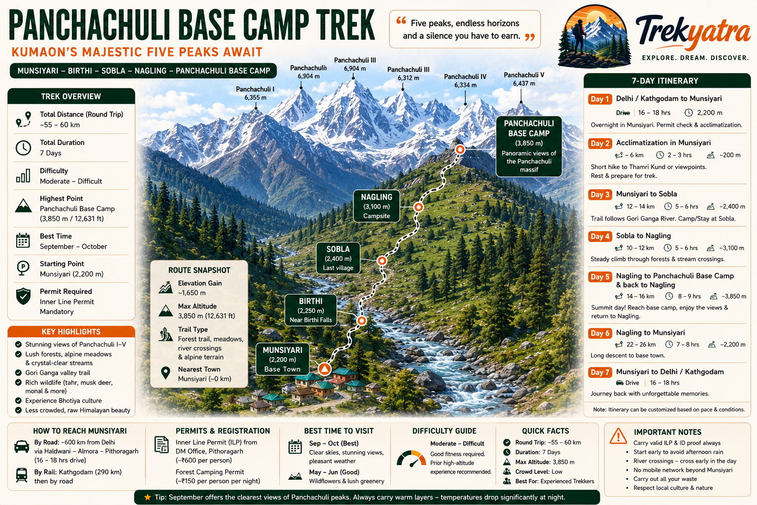
The Panchachuli Base Camp Trek is a 55–60 km round-trip trail in Pithoragarh, Uttarakhand, reaching 3,850 m at the foot of five Himalayan peaks. Best season: September–October. An Inner Line Permit is mandatory.
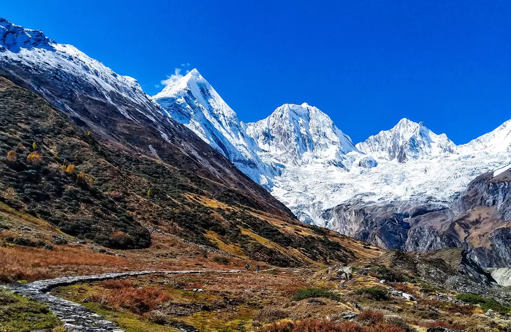
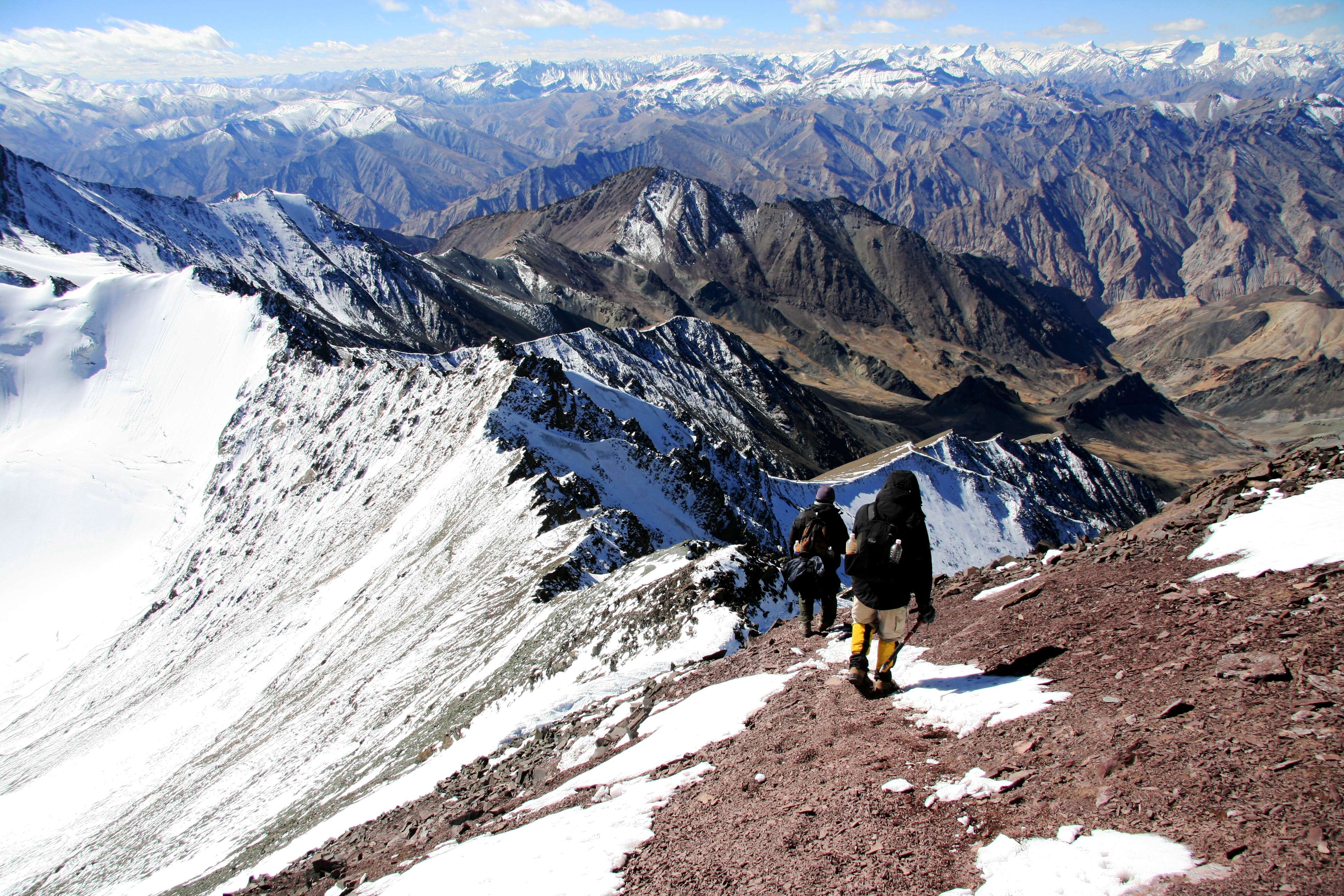
Tucked away in the high reaches of Pithoragarh district, Uttarakhand, the Panchachuli Base Camp Trek is one of the Kumaon Himalayas' best-kept secrets. The trek leads you to the foot of the Panchachuli massif — five snow-capped peaks that rise dramatically above the valley, the highest of which, Panchachuli II, tops out at 6,904 m. The base camp itself sits at approximately 3,850 m (12,631 ft), well within reach of fit, acclimatised trekkers yet far enough from the tourist circuit to feel genuinely wild.
While Kedarnath, Roopkund, and Valley of Flowers attract tens of thousands of visitors each season, the Panchachuli Base Camp sees a fraction of that footfall. The result is an experience that feels earned — pristine campsites, unhurried trails through oak and rhododendron forests, and a sky full of stars untainted by light pollution. If you are tired of shoulder-to-shoulder queues on famous Himalayan trails, this is the trek you have been looking for in the 2026 trekking season.
The case for Panchachuli Base Camp starts with the view and only gets stronger from there.
Five summits, one panorama. Panchachuli I (6,355 m), Panchachuli II (6,904 m), Panchachuli III (6,312 m), Panchachuli IV (6,334 m), and Panchachuli V (6,437 m) form a wall of ice and rock that dominates the skyline from the base camp. At sunrise, the alpenglow on those five peaks is routinely described by trekkers as one of the finest sights in the Indian Himalayas.
Mythology woven into the landscape. Local legend holds that the Pandavas cooked their last meal on these peaks before ascending to heaven — pancha means five and chuli means cooking hearth in Kumaoni. That spiritual resonance runs through every village on the route.
Cultural depth. The route passes through the villages of Dar, Sobla, and surrounding hamlets where Bhotiya communities have lived for centuries. Their distinctive architecture, traditional dress, and warm hospitality offer a cultural dimension that purely alpine treks often lack.
Wildlife. The upper reaches of this valley fall within snow leopard habitat. Sightings are rare but not unheard of. Himalayan tahr, musk deer, and dozens of bird species including the Himalayan monal are common companions.
Uncrowded. On a busy day at base camp you might share the space with one or two other groups. That kind of solitude is increasingly hard to find in the Himalayas.
At a glance
Ask TrekSage about Panchachuli Base Camp Trek
Get instant answers grounded in verified trek data — beginner-friendliness, best months, permits, packing, and more.
The route at a glance
The standard route runs: Munsiyari → Birthi → Sobla → Nagling → Panchachuli Base Camp, covering approximately 55–60 km round trip. The trail follows the Gori Ganga River valley for much of its length, climbing steadily through forest, alpine meadow, and finally open moraine to reach the base camp.
Key landmarks along the way include Birthi Falls, a spectacular 126-metre waterfall visible from the road near Munsiyari, and several river crossings over the Gori Ganga and its tributaries — some on wooden bridges, others requiring a careful ford. The final approach to base camp crosses loose scree fields with stunning views opening progressively as you gain altitude.
An alternate entry point exists via Dharchula to the south-east, joining the main trail near Sobla. This option suits trekkers arriving from Nepal or from the Dharchula side of Pithoragarh district, but adds a day of travel and requires the same Inner Line Permit.
Internal link: For more routes originating from Munsiyari, see our Munsiyari Trekking Guide. For a longer Kumaon adventure, consider the neighbouring Milam Glacier Trek.
Elevation Profile & Key Waypoints
| Waypoint | Altitude | Notes |
|---|---|---|
| Munsiyari | ~2,200 m | Trailhead town, last ATM and supplies |
| Birthi | ~2,250 m | Near Birthi Falls; road accessible |
| Sobla | ~2,400 m | Last village with basic guesthouse |
| Nagling | ~3,100 m | Established campsite, water source |
| Panchachuli Base Camp | ~3,850 m | Highest point of the standard route |
Cumulative ascent from Munsiyari to base camp is approximately 1,650 m. While that number is moderate by Himalayan standards, the daily distances and river crossings push the overall difficulty higher.
How Do I Get to the Panchachuli Base Camp Trailhead?
By road from Delhi: Munsiyari is approximately 600 km from Delhi via NH-9 and NH-309 through Haldwani, Almora, and Pithoragarh. The drive takes 16–18 hours by private vehicle or overnight bus. Shared jeeps operate from Pithoragarh to Munsiyari (5–6 hrs).
By rail: The nearest major railhead is Kathgodam Railway Station (~290 km from Munsiyari), well-connected to Delhi, Lucknow, and other major cities. From Kathgodam, take a bus or shared jeep via Almora and Pithoragarh.
By air: Pantnagar Airport (approx. 300 km from Munsiyari) has limited scheduled flights from Delhi. Hiring a vehicle from the airport to Munsiyari is the fastest option but expensive. Most trekkers use the train-jeep combination.
What each day actually looks like
This 7-day itinerary is designed to include adequate acclimatisation and buffer time for weather delays.
Day 1 — Delhi / Kathgodam to Munsiyari
Mode: Overnight bus or train to Kathgodam, then shared jeep or private vehicle
Altitude on arrival: ~2,200 m
Notes: Depart Delhi/Kathgodam in the evening or early morning. The road journey climbs through Haldwani, Almora, Pithoragarh, and finally to Munsiyari. Arrive by evening, check into guesthouse, sort permits and supplies. Rest well — the acclimatisation process starts tonight.
Day 2 — Acclimatisation in Munsiyari
Distance: 4–6 km (short hike)
Altitude gain: Minimal
Notes: Munsiyari is the ideal acclimatisation base. Hike up to the Thamri Kund lake or walk to viewpoints above town for your first close look at the Panchachuli massif. Finalise guide and porter arrangements, confirm Inner Line Permit, and recheck gear. Early night.
Day 3 — Munsiyari to Sobla
Distance: ~12–14 km
Altitude: 2,200 m → ~2,400 m
Campsite/Stay: Basic guesthouse or camp near Sobla
Notes: The trail descends initially to the Gori Ganga valley before following the river upstream. Pass through Birthi (stop at Birthi Falls if time permits) and continue to Sobla. This is the last village with any form of roofed accommodation. The gradient is gentle; it's a good day to find your trail legs.
Day 4 — Sobla to Nagling
Distance: ~10–12 km
Altitude: ~2,400 m → ~3,100 m
Campsite: Nagling campsite
Altitude gain: ~700 m
Notes: The trail climbs more assertively today through mixed forest. River crossings multiply — cross before noon if possible as glacial meltwater raises levels through the afternoon. The forest opens up near Nagling and the Panchachuli peaks begin to fill the view ahead. Set up camp early, drink plenty of water, and acclimatise.
Day 5 — Nagling to Panchachuli Base Camp and Back to Nagling
Distance: ~14–16 km (round trip)
Altitude: ~3,100 m → ~3,850 m → ~3,100 m
Altitude gain/loss: ~750 m each way
Notes: This is the summit day of the trek. Start no later than 6:00 am. The trail climbs through alpine meadows and scree to the base camp. The panorama of Panchachuli I–V from this point is the highlight of the entire route. Spend an hour at base camp before descending back to Nagling for the night. Do not rush the descent — scree can be treacherous.
Day 6 — Nagling to Munsiyari
Distance: ~22–26 km
Altitude: ~3,100 m → ~2,200 m
Notes: A long descent day. The route reverses Days 3–4, moving quickly with gravity on your side. Stop again at Sobla for tea. Aim to reach Munsiyari by late afternoon. Celebrate with a warm meal; your legs have earned it.
Day 7 — Munsiyari to Kathgodam / Delhi
Mode: Shared jeep or private vehicle, then bus or train
Notes: Depart Munsiyari early (shared jeeps typically leave by 5–6 am) for the long road journey back to Kathgodam or Pithoragarh. Overnight bus or train back to Delhi.
⚠️ Day-wise distances are estimates based on approximate trail data. GPS-verified stage distances should be confirmed with local guides or updated topo maps before publication.
When to go
Pre-monsoon: May–June (Good)
Trails are open, rhododendrons and wildflowers are in full bloom, and there is still enough residual snow to make the upper sections dramatic. Daytime temperatures at base camp can be pleasant (5–12°C) but cold fronts are possible. This window is popular with trekkers who cannot travel in autumn.
Monsoon: July–August (Avoid)
The southwest monsoon brings heavy rainfall to Kumaon from late June through August. Trails become slippery, river crossings turn dangerous, leeches emerge in force, and cloud cover obscures the peaks entirely. This window is strongly advised against.
Post-monsoon: September–October (Best — Top Recommendation)
After the monsoon clears in September, the Kumaon Himalayas enter their finest season. Skies turn a deep, crystalline blue. The peaks are freshly snow-dusted and razor sharp against the horizon. Temperatures are stable — cool but not extreme. September is the single best month for this trek: crowds are minimal, weather windows are reliable, and the views are as good as they get.
Winter: November–April (Closed / Dangerous)
Heavy snowfall closes the higher trails from November onwards. Below-zero temperatures, avalanche risk, and road closures make this period unsuitable for the Panchachuli Base Camp route. The trek is effectively closed from late November through April.
Is this trek right for you?
Difficulty grade: Moderate to Difficult.
The trek is not technically demanding — there is no fixed rope, glacier crossing, or high-altitude pass — but several factors push it above a straightforward moderate grade:
- Daily distances of 10–14 km (up to 26 km on the return day) on uneven terrain
- Altitude above 3,500 m on the summit day, requiring genuine acclimatisation
- River crossings that demand careful footwork and timing
- Loose scree on the final approach to base camp
- Remote location — evacuation in an emergency is slow
Recommended fitness preparation (4–6 weeks before departure):
- 30–45 minutes of cardio (running, cycling, swimming) five days a week
- Stair climbing with a loaded pack (10–12 kg) three times a week
- At least two day hikes of 15+ km in the weeks before the trek
- If possible, one prior multi-day Himalayan trek (Kedarkantha, Brahmatal, or similar) as experience baseline
Suitable for: Trekkers with at least one prior multi-day Himalayan trek experience. Not recommended for absolute beginners.
Internal link: See our full Altitude Sickness Prevention Guide before you go.
What permits you need
This section is mandatory reading — do not skip it.
Inner Line Permit (ILP)
Panchachuli Base Camp falls within a restricted zone close to the Indo-Nepal and Indo-Tibet border. All trekkers — Indian nationals and foreign nationals — must carry a valid Inner Line Permit (ILP) to enter this area.
- Issuing authority: District Magistrate (DM) Office, Pithoragarh
- Online option: Uttarakhand government's official ILP portal (check the current portal URL at the time of trekking — the system has been periodically updated)
- Cost: Approximately ₹600 per person (⚠️ 2026 fee — verify with DM Pithoragarh office)
- Documents required: Valid photo ID (Aadhaar card for Indian nationals; passport for foreign nationals), passport-size photographs, completed application form
- Validity: Typically issued for the duration of your trek; specify entry and exit dates on application
- Processing time: Same day if applied in person at the DM Office; allow 2–3 working days for online applications
Forest Department Camping Permit
Campsites within the forest zone require a separate Forest Department camping permit.
- Cost: Approximately ₹150 per person per night
- Where to obtain: Forest Range Office in Munsiyari or coordinated through your registered guide/operator
KMVN Guide Registration
Kumaon Mandal Vikas Nigam (KMVN) recommends — and for foreign nationals in border zones, effectively requires — trekking with a registered local guide. Guide registration details are confirmed at the KMVN office in Munsiyari. Always register your group and intended route with the local police post in Munsiyari before departure.
How to Apply for the Inner Line Permit — Step by Step
- Gather documents: Aadhaar/passport, 2 passport-size photos, trek dates and route description
- Online: Visit the Uttarakhand ILP portal, create an account, submit scanned documents, pay fee online, download permit PDF
- In person: Visit DM Office Pithoragarh (open on working days); submit form at the ILP counter; permit typically issued the same day
- At Munsiyari: In some cases a permit can be endorsed at the Munsiyari SDM office — confirm current procedure locally as administrative arrangements can change
- Carry physical copies of the permit on trail; digital copies are a backup, not a substitute, at remote checkposts
Internal link: Full step-by-step walkthrough at our Uttarakhand Inner Line Permit Guide.
What this trek will cost you
DIY Budget (per person, 7 days)
| Item | Estimated Cost (₹) |
|---|---|
| Transport (Delhi–Munsiyari–Delhi, bus + jeep) | 4,000–6,000 |
| Inner Line Permit | ~600 |
| Forest camping permit (3 nights × ₹150) | ~450 |
| Accommodation — Munsiyari (2 nights guesthouse) | 800–1,200 |
| Camping nights (3 nights, tent/sleeping gear rental) | 1,500–2,400 |
| Food (7 days × ₹600–800/day) | 4,200–5,600 |
| Registered local guide (5 trail days × ₹1,000–1,500/day) | 5,000–7,500 |
| Porter, if required (5 trail days × ₹800–1,200/day) | 4,000–6,000 |
| Miscellaneous (tips, emergency, sundries) | 1,000–2,000 |
| Total DIY estimate | ₹18,000–25,000 |
⚠️ All cost estimates are indicative for 2026 and should be verified with operators and local contacts before publishing. Transport fares in particular fluctuate with fuel prices.
Organised Package (per person, all-inclusive)
A reputable operator-led package covering transport, permits, accommodation, meals, guide, porter, and camping equipment typically costs ₹25,000–40,000 per person for a 7-day itinerary.
Operators worth considering:
- Indiahikes — well-structured itineraries, safety systems, experienced guides (⚠️ Confirm current Panchachuli offering)
- Trek the Himalayas — strong Kumaon presence (⚠️ Confirm current Panchachuli offering)
- Local Munsiyari guides — most cost-effective, genuine local knowledge; ask at KMVN Munsiyari for registered guide lists
Internal link: Also browse our roundup of Kumaon Himalaya Treks for multi-trek package ideas.
What to pack
Pack for a 3,850 m altitude environment with rapid weather changes.
Clothing (Layering System)
- Moisture-wicking thermal base layers (top and bottom)
- Mid-layer fleece or down jacket
- Waterproof and windproof outer shell jacket
- Trekking trousers × 2 (one lightweight, one insulated)
- Gaiters (essential for scree and snow patches)
- Warm hat, balaclava, sun hat
- Gloves (liner + waterproof shell)
- Trekking socks × 4–5 pairs (merino wool preferred)
Footwear
- Waterproof ankle-support trekking boots (broken in before the trek — non-negotiable)
- Lightweight camp sandals or crocs
Internal link: See our Best Trekking Boots India guide for 2026 recommendations.
Gear
- Trekking poles × 2 (critical for river crossings and scree)
- Headlamp + spare batteries
- Sleeping bag rated to -10°C (essential — Nagling and base camp nights are cold)
- Backpack 50–60 L (if DIY) or 35 L day pack (if porter used)
- Trekking tent (DIY trekkers; rentable in Munsiyari)
- Water bottles × 2 (1 L each) + water purification tablets or filter
- Sunglasses (UV400 or glacier glasses for base camp)
- Trekking map or downloaded offline GPS route
Documents
- Inner Line Permit (physical copy)
- Forest camping permit
- Aadhaar / Passport
- Travel insurance documents (emergency evacuation cover mandatory)
- Emergency contact card
Medical & Safety
- Diamox (Acetazolamide) — altitude sickness prophylaxis; consult a doctor before use
- Dexamethasone (emergency HACE/HAPE kit — guide should also carry)
- Ibuprofen, paracetamol, antihistamine, antidiarrheal
- Blister kit, bandages, antiseptic cream
- Personal prescription medications
- Pulse oximeter (highly recommended above 3,000 m)
Electronics
- Power bank (20,000 mAh minimum — no charging points beyond Munsiyari)
- Satellite communicator (e.g., Garmin inReach) — strongly recommended
- Camera
Internal link: Full gear breakdown at our Trekking Packing List India guide.
Staying safe on the mountain
Altitude Sickness & AMS
Acute Mountain Sickness (AMS) can affect anyone above 2,500 m regardless of fitness. Symptoms include headache, nausea, dizziness, and fatigue. Follow the golden rule: acclimatise properly, ascend gradually, never push through symptoms.
- If a trekker develops symptoms of HACE (High Altitude Cerebral Oedema) — severe headache, confusion, loss of coordination — or HAPE (High Altitude Pulmonary Oedema) — breathlessness at rest, pink frothy cough — descend immediately and call for emergency assistance. These conditions are life-threatening.
- Do not ascend more than 300–500 m per day above 2,500 m (the itinerary above respects this).
- Stay hydrated (3–4 litres of water daily).
- The Day 2 acclimatisation day in Munsiyari is not optional padding — it is a safety measure.
Weather
- Afternoon thunderstorms are common in the Kumaon Himalayas, even in the best seasons. Start trekking by 6:00 am to reach campsites before midday storms develop.
- Check the India Meteorological Department (IMD) forecast for Pithoragarh district before each day.
River Crossings
- Glacial rivers peak in the afternoon as meltwater flows increase. Always cross rivers before noon.
- Unbuckle your pack waist belt and chest strap before entering water so you can shed the pack if swept off your feet.
- Use trekking poles for balance; cross diagonally facing upstream.
Registration & Communication
- Register your trek with the local police post in Munsiyari before departure and sign out on return.
- BSNL is the only mobile network with any coverage beyond Munsiyari, and it is patchy. Carry a satellite communicator for genuine emergencies.
- Share your detailed itinerary and emergency contacts with someone at home.
Emergency Contacts
- SDRF (State Disaster Response Force) Munsiyari: Contact number to be confirmed with local SDRF office — (⚠️ Specific number not verifiable for 2026; check with SDRF Uttarakhand before publishing)
- Pithoragarh District Hospital: Main emergency hospital for the region
- Uttarakhand Emergency Helpline: 1070
Travel Insurance
Travel insurance with emergency helicopter evacuation cover is not optional on this trek — it is a necessity. Verify your policy explicitly covers high-altitude trekking above 3,500 m.
Similar treks to explore
Nubra Valley Trek: Routes, Permits & Best Time (2026)
The Nubra Valley trek is a 65–90 km high-altitude route in Ladakh crossing Khardung La (5,359 m) into a cold-desert valley at 3,048 m, completed in 7 days.
Sham Valley Trek: Complete Beginner's Guide (2026)
The Sham Valley Trek is Ladakh's most beginner-friendly high-altitude trek, reaching a maximum of ~3,700m over 4–5 days.
Stok Kangri Trek: Complete Guide for Climbers
The Stok Kangri trek is a high-altitude mountaineering route in Ladakh, India, reaching a summit of 6,153 metres — one of India's most accessible 6,000m+ peaks.
Common questions answered
The Panchachuli Base Camp sits at approximately 3,850 m (12,631 ft). This is the highest point reached on the standard trekking route. To provide context: the Panchachuli peaks themselves soar far higher — Panchachuli II, the highest, stands at 6,904 m — but those summits are the domain of technical mountaineering expeditions, not trekkers. The base camp offers a front-row view of all five peaks without the technical demands.
Live Conditions
Real-time weather & trail status
Trail Conditions
Crowdsourced reports from trekkers who've done this route
Sign in to add a trip report
Find a Trek Buddy
Connect with trekkers planning the same route
No buddies yet for this trek
Sign in and be the first to post a planning signal.