Why Pin Parvati Pass Trek is on every trekker's list
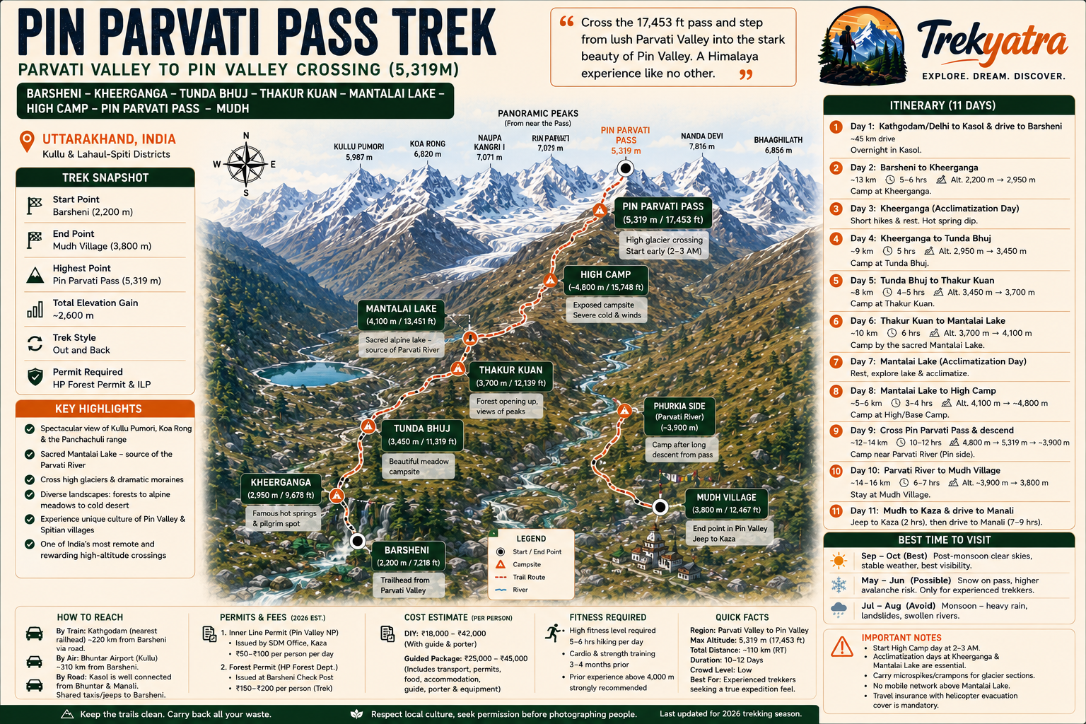
The Pin Parvati Pass trek is not a trail for the faint-hearted. At 5,319 metres above sea level, this high-altitude crossing connects two of Himachal Pradesh's most contrasting valleys — the verdant, river-carved Parvati Valley in Kullu district and the stark, cold-desert expanse of Pin Valley in Spiti. Covering approximately 110 km over 10 to 12 days, it is widely regarded as one of the hardest and most rewarding multi-day treks in India.
From the hot springs of Kheerganga to the ice-draped approach to the pass, from the sacred shores of Mantalai Lake to the Buddhist villages of Pin Valley, every kilometre of this route demands respect, preparation, and a genuine love for raw wilderness. If you have that, the Pin Parvati Pass will reward you with experiences that few Indian treks can match.
In an era when popular Himalayan treks are increasingly crowded, Pin Parvati remains blissfully remote. Trekker footfall on this route is a fraction of what you'll find on the Kedarkantha or Triund trails. That remoteness is the first and most compelling reason to choose it.
But the real magic lies in the dramatic landscape transition. You begin in the Parvati Valley — dense pine and oak forests, cascading waterfalls, the smell of cannabis in the air — and you emerge, after crossing the pass, into a completely different world: a high-altitude cold desert of browns, greys, and blues, where Buddhist prayer flags flap in the thin Spitian wind.
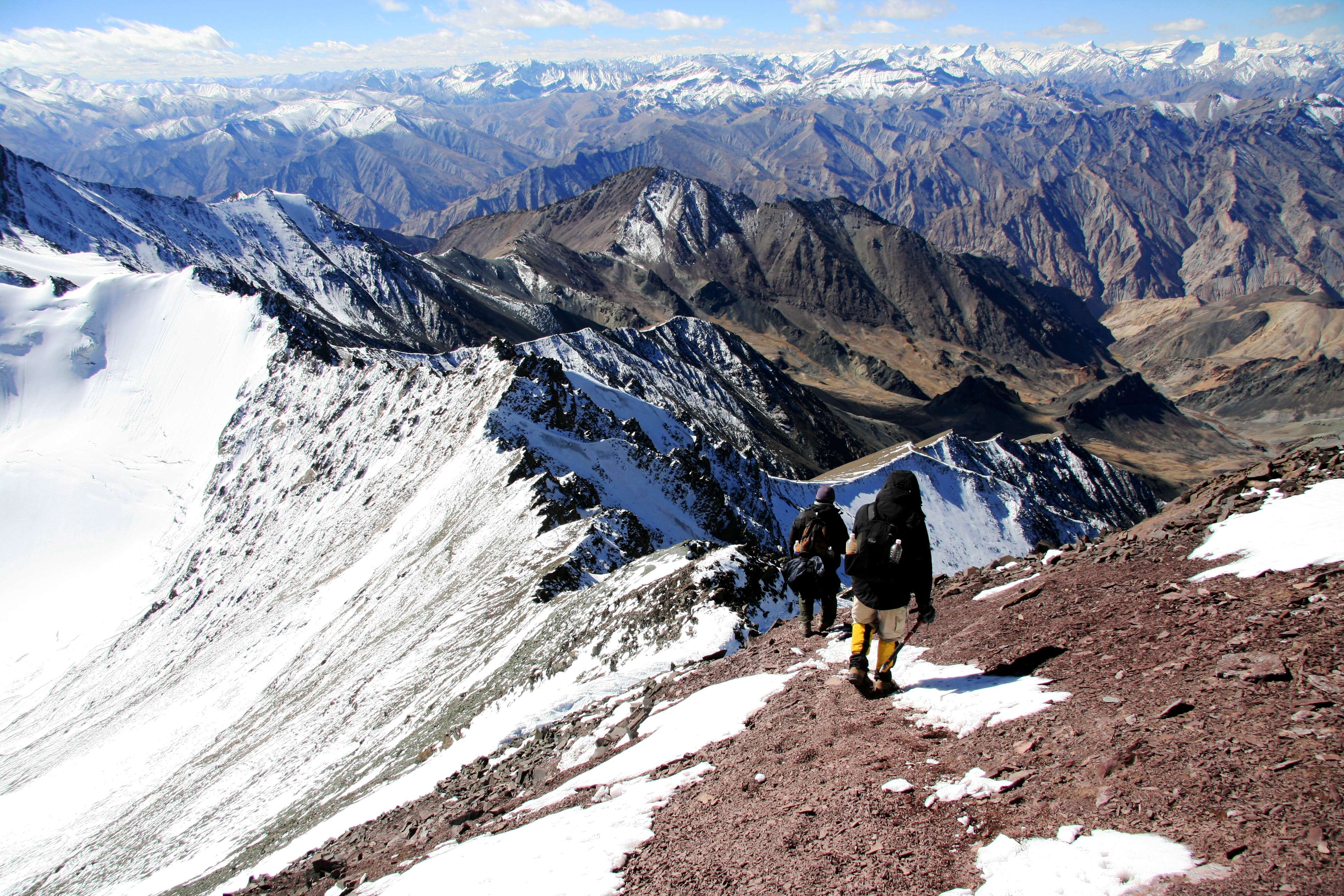
Along the way, the views are extraordinary. Peaks like Kullu Pumori and Koa Rong dominate the skyline near the pass, their flanks cloaked in glacial ice. The Mantalai Lake, sitting at over 4,100m, is one of the most serene high-altitude lakes in India and the source of the Parvati River — a deeply sacred site for Hindu pilgrims. The moraines, glaciers, boulder fields, and high meadows you traverse ensure that no two days feel the same.
For trekkers who have notched up a few moderate trails and are asking "what's next?", the Pin Parvati Pass is the definitive answer.
What Makes This Trek Unique
The contrast between the two valleys is not merely scenic — it is cultural and civilisational. The Parvati Valley side is rooted in Hindu tradition; the Parvati River is sacred, Mantalai Lake draws pilgrims, and the villages of Kasol and Barsheni have a well-worn trekkers' circuit. Cross the pass, and within a few hours you are in a world of Tibetan Buddhism — whitewashed monasteries, mani walls, and the quiet dignity of Spitian villages like Mudh.
Very few treks in India offer this kind of geographical and cultural duality in a single journey. Add to that the near-complete absence of phone network above Mantalai Lake, no tea-shop infrastructure beyond the lower reaches, and genuinely glaciated terrain that requires careful navigation, and you have a trek that delivers a truly expedition-grade experience.
At a glance
Ask TrekSage about Pin Parvati Pass Trek
Get instant answers grounded in verified trek data — beginner-friendliness, best months, permits, packing, and more.
The route at a glance
The standard direction is west to east: starting at Barsheni in Parvati Valley and ending at Mudh village in Pin Valley. This direction is preferred because the Parvati Valley side has a longer, more gradual elevation gain, giving your body more time to acclimatise before the glaciated high-altitude section.
The route follows the Parvati River upstream from Barsheni, passing through Kheerganga's famous hot springs, the dense rhododendron forests of Tunda Bhuj, and the boulder-strewn upper valley above Thakur Kuan. You reach Mantalai Lake — the spiritual and geographical high point before the pass — after roughly five days of trekking. From Mantalai, a high camp approach leads to the 5,319m pass, which involves crossing a significant glacier on both the Parvati and Pin sides. The descent into Pin Valley brings you to the Parvati River's upper tributaries, then downstream to the ancient village of Mudh, from where jeeps connect to Kaza and onward to Manali.
The total trekking distance is approximately 110 km, with the maximum elevation at 5,319m at the pass.
Elevation Profile and Key Waypoints
| Campsite | Approximate Altitude |
|---|---|
| Barsheni (start) | ~2,200m |
| Kheerganga | ~2,950m |
| Tunda Bhuj | ~3,450m |
| Thakur Kuan | ~3,700m |
| Mantalai Lake | ~4,100m |
| High / Base Camp | ~4,800m |
| Pin Parvati Pass | 5,319m |
| Mudh Village | ~3,800m |
Note: Altitudes for campsites other than the pass and Mudh are approximate and may vary by 50–100m depending on the source.
What each day actually looks like
This 11-day itinerary starts from Kasol/Bhuntar and ends at Kaza, with a buffer day built in for weather contingencies.
Day 1 — Kasol to Barsheni to Kheerganga
Distance: ~13 km trek | Altitude gain: 2,200m → 2,950m
Drive from Kasol to Barsheni (shared jeep, ~45 minutes). Begin the trek on the well-worn trail to Kheerganga, passing through Kalga, Pulga, and Rudra Nag waterfall. Arrive at Kheerganga's camping ground by late afternoon. Soak in the natural hot springs — a ritual that will feel even more earned on the return leg. Camp overnight.
Day 2 — Acclimatisation at Kheerganga
Altitude: 2,950m
A mandatory rest and acclimatisation day. Take short walks around the upper meadow, stay hydrated, and observe how your body responds to the altitude. This day pays dividends later on the glacier.
Day 3 — Kheerganga to Tunda Bhuj
Distance: ~9 km | Altitude gain: 2,950m → 3,450m
The trail leaves the tourist zone behind almost immediately. You enter dense birch and rhododendron forest, cross multiple streams, and begin to sense the true remoteness of the upper valley. Tunda Bhuj is a wide meadow — pitch camp here.
Day 4 — Tunda Bhuj to Thakur Kuan
Distance: ~8 km | Altitude gain: 3,450m → 3,700m
The landscape opens up as you gain elevation. The valley narrows, the Parvati River roars alongside, and the first glimpses of permanent snow appear on the ridgelines above. Thakur Kuan is a relatively flat campsite beside the river.
Day 5 — Thakur Kuan to Mantalai Lake
Distance: ~10 km | Altitude gain: 3,700m → 4,100m
This is one of the most demanding days of the trek's lower half. The trail involves significant boulder hopping, multiple stream crossings, and loose scree sections. Mantalai Lake appears suddenly — a vast, serene expanse at 4,100m. Camp here, close to the lake's edge. The silence is extraordinary.
Day 6 — Acclimatisation at Mantalai Lake
Altitude: 4,100m
Do not skip this day. Spend the morning exploring the lake's perimeter, check your SpO2 with a pulse oximeter (readings below 88–90% at rest warrant attention), and prepare your gear for the high-altitude push ahead. Eat well and sleep early.
Day 7 — Mantalai Lake to High Camp
Distance: ~5–6 km | Altitude gain: 4,100m → 4,800m
This short but gruelling day takes you across moraine fields and up onto the glacier's lower reaches. The terrain is loose and energy-sapping. High camp at approximately 4,800m is exposed — ensure tents are well-anchored. Winds can be severe. Sleep by 8 PM; tomorrow is a 2 AM start.
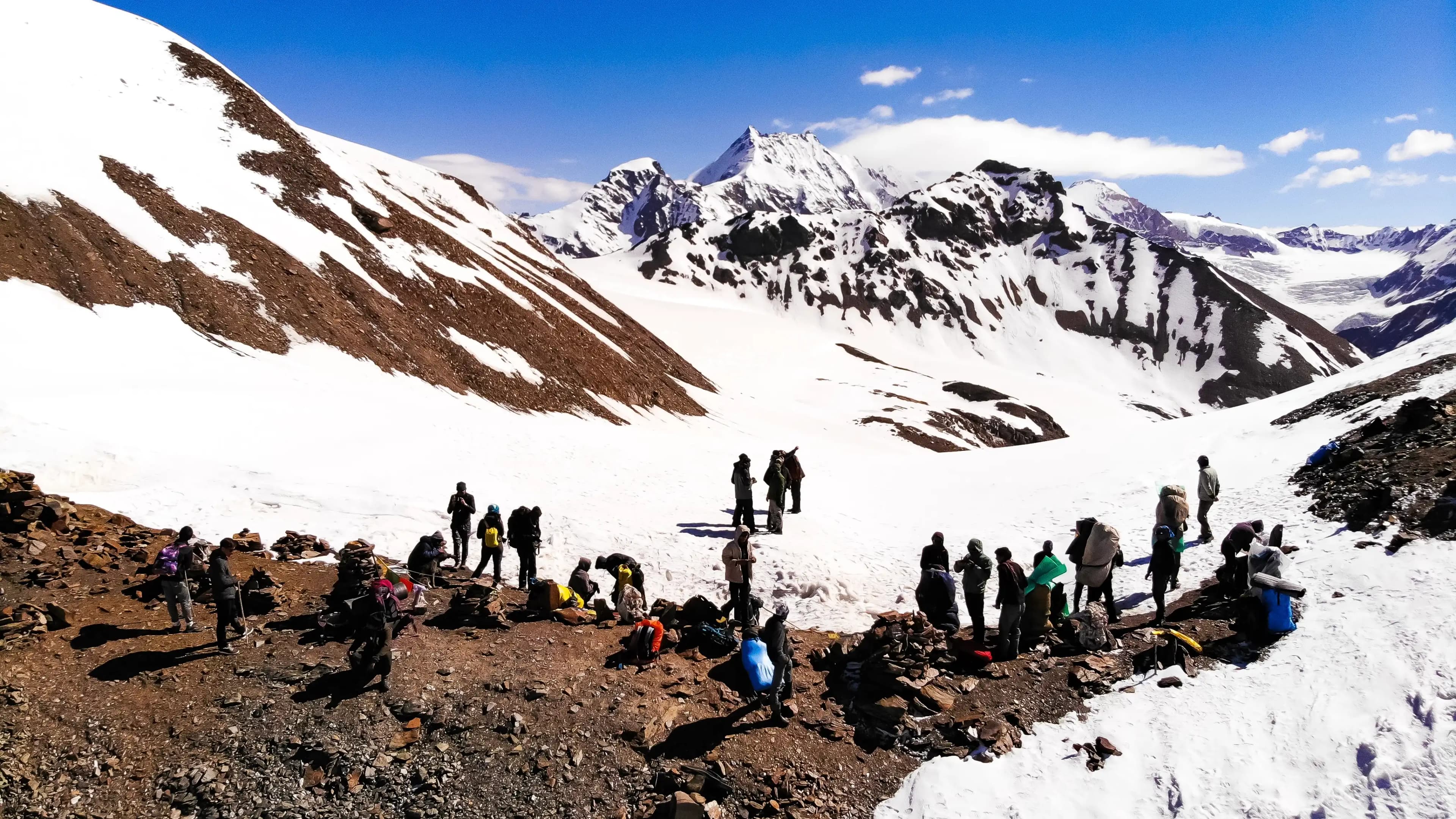
Day 8 — High Camp to Pass to Parvati River (Pin Valley side)
Distance: ~12–14 km | Altitude: 4,800m → 5,319m → ~3,900m
The crux of the entire trek. Wake at 2–3 AM, don your microspikes or crampons, and begin the glacier crossing by headlamp. The goal is to summit the 5,319m pass before midday, when warming temperatures destabilise snow and clouds build rapidly. The views from the top — across both valleys, with Kullu Pumori and Koa Rong flanking the horizon — are among the finest in the Indian Himalaya. The descent into Pin Valley is steep and technical on loose rock and snow. Camp near the Parvati River crossing on the Pin side.
Day 9 — Parvati River Crossing to Mudh Village
Distance: ~14–16 km | Altitude: descends to 3,800m
Cross the Parvati River early in the morning when water levels are lowest (glacial melt peaks in the afternoon). The trail follows the Pin River downstream through an alien, beautiful landscape of eroded cliffs and sparse vegetation. Mudh village — the last inhabited point in the upper Pin Valley — comes as a warm, welcome sight. Stay in a local homestay.
Day 10 — Buffer / Contingency Day
Built in for weather delays, injury, or fatigue. If not needed, use this day to rest in Mudh and explore its ancient monastery.
Day 11 — Mudh to Kaza to Manali
Jeep from Mudh to Kaza (approximately 45 km, ~2 hours on mountain roads). From Kaza, buses or shared taxis connect to Manali via the Kunzum Pass (open June–October) or via Shimla year-round. The journey to Manali takes 7–9 hours depending on route and road conditions.
When to go
The trekking window for Pin Parvati Pass is narrow. Getting the timing wrong is not just an inconvenience — it can be genuinely dangerous.
September to October (Recommended): The golden window. Post-monsoon skies are crystal clear, the Parvati Valley's vegetation is at its most vibrant, and the pass is reliably snow-consolidated enough for crossing. Mid-September to early October is the single best period. After mid-October, temperatures at high camp drop severely and early snowfall can block the pass unpredictably.
June (Experienced Trekkers Only): The pass may still hold significant snow from winter accumulation, increasing avalanche risk on the approach. Suitable only for rope-trained, experienced alpine trekkers. Not recommended for most trekkers.
July–August (Avoid): The southwest monsoon brings heavy rainfall to the Parvati Valley, making river crossings dangerous and triggering frequent landslides on the approach trails. Leeches are a persistent problem below 3,000m. Avalanche risk on the glacier is elevated. This window is not recommended.
November to May (Pass Closed): The pass is buried under winter snow and is inaccessible. Attempting this period is extremely dangerous.
Pin Parvati Pass Trek Weather Month by Month
- June: Partial snow on pass; cold nights (-5°C to -10°C at camp); experienced trekkers only; risk of avalanche on glacier
- July–August: Monsoon season; heavy rain on Parvati side; landslide risk; leeches; flooded river crossings; avoid
- September–October: Best conditions; stable weather; clear views; cool nights at altitude; strongly recommended
- November onwards: Pass closes; snowstorms; sub-zero temperatures at base camp; do not attempt
Note: High-altitude weather in the Himalaya is inherently unpredictable. Even in the ideal September–October window, sudden storms can pin trekkers at camp for 24–48 hours. Always carry an extra buffer day of rations.
Is this trek right for you?
Grade: Very Difficult / Expert Level
This is one of the hardest multi-day treks in India. Here is why:
- Altitude: The 5,319m pass pushes most trekkers close to their physiological limits. Acute Mountain Sickness (AMS) risk is significant.
- Glacier crossing: Both the Parvati and Pin Valley approaches to the pass involve glaciated terrain. Route-finding on ice in pre-dawn darkness is not trivial.
- River crossings: Multiple crossings of the Parvati River in its upper reaches. Water levels fluctuate dramatically with time of day.
- No rescue infrastructure: Above Mantalai Lake, there are no villages, no phone network, and no quick evacuation options. A helicopter is the only emergency exit — and weather often prevents flying.
- Duration: 10–12 consecutive days of physical exertion at altitude taxes the body cumulatively.
Who should attempt this trek:
- Trekkers with prior experience above 4,000m (e.g., Hampta Pass, Bhrigu Lake)
- Individuals who can sustain 6–8 hours of walking per day carrying a 10–15 kg pack
- Trekkers who have completed cardio and strength training for at least 3 months prior
Who should not attempt: Beginners, those with cardiac or respiratory conditions, anyone who has not trekked above 3,500m before. There are many excellent stepping-stone treks in Himachal that will build you toward this goal.
What permits you need
Two permits are mandatory for the Pin Parvati Pass trek. Carry physical copies of both at all times — checkposts on both sides will ask to see them.
1. Inner Line Permit (ILP) for Pin Valley National Park
Required for the Pin Valley (Spiti) side of the trek. Issued by the Sub-Divisional Magistrate (SDM) office in Kaza. The permit can also be applied for through the Himachal Pradesh government's official online portal (himachal.nic.in or the ePass HP portal — verify the current URL before travel).
- Cost: Approximately INR 50–100 per day per person
- Processing time: Same day if in person at Kaza SDM office; allow 2–3 days for online processing
- Validity: Covers the duration of your trek in the national park area
2. Forest Department Permit — Parvati Valley Section
Required for trekking through the upper Parvati Valley beyond Kheerganga. Obtained at the forest checkpost at Barsheni at the trailhead.
- Cost:
- Carry your Aadhaar card or passport for identity verification at this checkpost.
Foreigners: Non-Indian nationals should verify restricted area rules with the Himachal Pradesh Tourism office or the Indian embassy well in advance. Pin Valley has historically required additional documentation for foreign trekkers.
Tip: Most reputable trekking agencies in Kasol and Kaza handle permit paperwork as part of their package. If going DIY, sort permits before beginning the trek — you cannot obtain the Pin Valley ILP mid-route.
What this trek will cost you
DIY Budget (Per Person)
| Item | Approximate Cost (INR) |
|---|---|
| Bus/taxi Bhuntar to Kasol | 200–300 |
| Shared jeep Kasol to Barsheni | 150–200 |
| Permits (both) | 500–1,000 |
| Food (10–11 days, self-cooked + basic dhabas) | 5,500–8,800 (INR 500–800/day) |
| Local guide (10 days) | 15,000–20,000 (INR 1,500–2,000/day) |
| Porter (optional, 10 days) | 12,000–15,000 (INR 1,200–1,500/day) |
| Camping gear rental (if not owned) | 2,000–5,000 |
| Jeep Mudh to Kaza | 300–500 per seat |
| Transport Kaza to Manali | 500–800 per seat |
| DIY Total (without guide/porter) | ~INR 10,000–18,000 |
| DIY Total (with guide + porter) | ~INR 25,000–42,000 |
[Costs — INR figures are estimates based on 2025–2026 regional pricing trends; verify current rates locally]
Guided Package (Per Person)
All-inclusive packages from Kasol-based agencies range from INR 25,000 to INR 45,000 per person, depending on group size, agency reputation, and what is included (tent quality, food, guide experience, porter ratio). Smaller groups and premium agencies charge toward the higher end.
Worth splurging on: A quality local guide (non-negotiable on this route), a 4-season tent rated to at least -15°C, and a sleeping bag rated to -20°C. Cutting corners on shelter and warmth at 4,800m is a serious risk.
What to pack
Clothing
- Moisture-wicking base layer (top and bottom) × 2
- Mid-layer fleece jacket
- Hardshell waterproof and windproof jacket
- Down jacket (at least 600-fill power)
- Convertible trekking pants × 2
- Thermal innerwear (top and bottom)
- Wool or synthetic trekking socks × 5 pairs
- Lightweight gloves + heavyweight insulated gloves
- Balaclava
- Sun hat / wide-brim cap
- Gaiters (essential for snow and scree)
Footwear
- High-ankle waterproof trekking boots (broken in before the trek)
- Camp sandals or light shoes
- Microspikes or crampons (for glacier sections)
Equipment
- 4-season tent (freestanding, rated to -20°C wind chill)
- Sleeping bag rated to -20°C
- Trekking poles × 2
- 60L+ backpack with rain cover
- Dry bags for electronics and documents
- Headlamp + spare batteries (you will need this for the 2 AM summit push)
- Trekking rope (guide will carry; confirm before departure)
Safety & Health
- Comprehensive first-aid kit
- ORS sachets × 10+
- Diamox (acetazolamide) — consult your doctor before the trek [see altitude sickness section]
- Pulse oximeter
- Emergency whistle
- Ibuprofen and paracetamol
- Blister plasters and moleskin
- Sunscreen SPF 50+ and UV-protective sunglasses
Documents
- Aadhaar card / passport (originals + photocopies)
- Both permits (physical copies)
- Emergency contacts list (printed)
- Travel insurance policy (with helicopter evacuation cover)
Nutrition
- High-calorie snacks: nuts, energy bars, dark chocolate
- Electrolyte powder sachets
- Instant oats / noodles for camp meals
- Dried fruits and nut mixes
See our full trekking gear checklist for a more detailed breakdown.
Staying safe on the mountain
Acclimatise — do not rush. The built-in rest days at Kheerganga and Mantalai Lake are not optional padding; they are essential physiology. Skipping them dramatically increases your AMS risk.
River crossings — early morning only. Glacial rivers are at their lowest between 6–9 AM, before solar melt peaks in the afternoon. Never attempt a river crossing above knee depth without a trekking pole and an unclipped pack hip belt.
Glacier crossing — start at 2–3 AM. Aim to summit the pass before noon. Morning snow is firm and safe; afternoon warming creates unstable conditions, increasing crevasse and slip risk.
Weather windows. If clouds build or visibility drops to under 50m on the glacier approach, turn back. No summit is worth a white-out crossing on ice.
Mobile network: BSNL works intermittently up to Kheerganga and sporadically to Mantalai Lake. Above Mantalai, assume zero network. A satellite communicator (e.g., Garmin inReach) is strongly recommended.
Emergency contacts:
- District Hospital Kaza: +91-1906-222233
- Himachal Pradesh Police Emergency: 112
- High Altitude Rescue, Kaza: contact through Kaza SDM office
Always register at the forest checkpost at Barsheni before starting the trek. This ensures that authorities have a record of your party size, expected return date, and emergency contacts.
Travel insurance with helicopter evacuation cover is non-negotiable on this route. A helicopter rescue from above Mantalai Lake to Bhuntar or Kullu can cost INR 2–4 lakh or more — insurance is far cheaper than the alternative.
Always hire a local guide. Not legally mandated, but practically essential. Local guides from Kasol or Kaza know the glacier route, river crossing points, and weather patterns in ways that no map or app can replicate.
Altitude Sickness: Prevention and Response
Acute Mountain Sickness (AMS) can affect anyone above 2,500m, regardless of fitness level. Symptoms include headache, nausea, dizziness, fatigue, and loss of appetite. At higher elevations, more serious conditions can develop:
- HACE (High Altitude Cerebral Oedema): Confusion, loss of coordination, severe headache. Medical emergency — descend immediately.
- HAPE (High Altitude Pulmonary Oedema): Breathlessness at rest, pink frothy cough, crackling sounds in lungs. Medical emergency — descend immediately and seek evacuation.
Golden rule: If symptoms worsen rather than improve after rest, descend. No target justifies gambling with HACE or HAPE.
Diamox (acetazolamide): Commonly prescribed at 125–250mg twice daily as a preventative measure. Consult a doctor before your trek — it is not suitable for everyone and has side effects including increased urination and tingling in extremities. Read our detailed guide on altitude sickness prevention.
Hydration: Drink 4–5 litres of water per day at altitude, even if you don't feel thirsty. Dehydration accelerates AMS.
Pulse oximeter readings: A healthy SpO2 at 4,000–5,000m is typically 80–90%. Readings below 85% SpO2 at rest are a red flag and want serious attention. Below 75%, consider immediate descent.
Similar treks to explore
Nubra Valley Trek: Routes, Permits & Best Time (2026)
The Nubra Valley trek is a 65–90 km high-altitude route in Ladakh crossing Khardung La (5,359 m) into a cold-desert valley at 3,048 m, completed in 7 days.
Sham Valley Trek: Complete Beginner's Guide (2026)
The Sham Valley Trek is Ladakh's most beginner-friendly high-altitude trek, reaching a maximum of ~3,700m over 4–5 days.
Stok Kangri Trek: Complete Guide for Climbers
The Stok Kangri trek is a high-altitude mountaineering route in Ladakh, India, reaching a summit of 6,153 metres — one of India's most accessible 6,000m+ peaks.
Common questions answered
The Pin Parvati Pass trek is classified as Expert / Very Difficult — one of India's hardest multi-day treks. At 5,319m, with glacier crossings, multiple river fords, 10–12 consecutive days of high-altitude exertion, and virtually no rescue infrastructure above Mantalai Lake, this route demands prior experience on treks above 4,000m (such as Hampta Pass or Bhrigu Lake), excellent physical fitness, and strong mental resilience. It is not suitable for beginners under any circumstances.
Live Conditions
Real-time weather & trail status
Trail Conditions
Crowdsourced reports from trekkers who've done this route
Sign in to add a trip report
Find a Trek Buddy
Connect with trekkers planning the same route
No buddies yet for this trek
Sign in and be the first to post a planning signal.