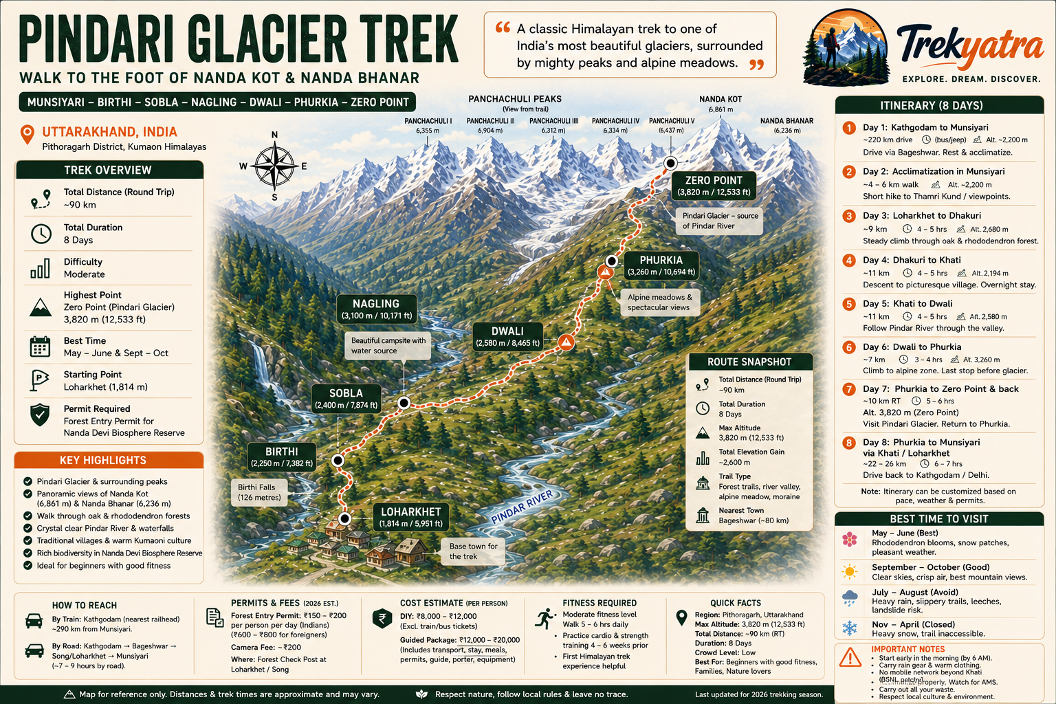
Why Pindari Glacier Trek is on every trekker's list
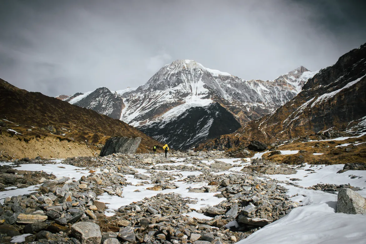
Imagine standing at Zero Point, the air thin and electric, as a vast tongue of ancient ice sweeps down between the flanks of Nanda Kot (6,861 m) and Nanda Bhanar (6,236 m). The Pindari Glacier — source of the turquoise Pindar River — stretches before you in a crescent of blue-grey ice, framed by some of the most dramatic peaks in the Kumaon Himalayas. This is your reward at the end of one of India's most beloved and approachable long-distance treks.
Located deep inside the Nanda Devi Biosphere Reserve in Uttarakhand, the Pindari Glacier trek covers approximately 90 km round trip, reaching a maximum altitude of roughly 3,820 m at Zero Point — high enough to feel genuinely Himalayan, yet well within reach of reasonably fit non-technical trekkers. Unlike many glacier treks in the Indian Himalayas, Pindari requires no ropes, crampons, or prior climbing experience. It is graded moderate, making it one of the best entry points to serious Himalayan trekking in India.
For the 2026 trekking season, Pindari remains one of the least commercialised glacier treks in the country. You will still encounter wooden PWD guesthouses, village women carrying firewood on the trails, and a quietude that has largely vanished from more famous routes. This guide gives you everything you need to plan a safe, rewarding, and budget-smart trek to the glacier.
With dozens of Himalayan treks competing for attention, why does Pindari continue to earn its loyal following year after year?
Accessibility without compromise. The Pindari Glacier is one of the few glaciers in India that a complete beginner can reach on foot. There is no technical terrain, no glacier crossing, and no altitude above 4,000 m. Yet the experience — walking beneath ice-capped peaks, crossing snowmelt streams, and sleeping in forest rest houses — feels entirely authentic.
The Kumaon landscape is unique. Unlike the rocky, treeless upper valleys of Lahaul-Spiti or Ladakh, the trail to Pindari passes through dense oak and rhododendron forests, terraced farmlands, and meadows thick with Himalayan wildflowers in spring. The biodiversity here, protected within the Nanda Devi Biosphere Reserve, is extraordinary — red-billed choughs, Himalayan monals, Himalayan black bears, and snow leopards (rarely glimpsed) all share this landscape.
Relative solitude. In 2026, Pindari sees far fewer trekkers than comparable routes like Kedarkantha, Triund, or even the Valley of Flowers. On many trail days, you may walk for hours meeting only local villagers and other trekkers heading in the opposite direction.
Cultural richness. The villages of Song, Loharkhet, Dhakuri, and especially Khati offer genuine encounters with Kumaoni mountain culture — stone houses, carved wooden doorways, local dals and rotis served on tin plates, and locals who have guided trekkers for generations.
Proximity to other great treks. Khati village is also the base for the Kafni Glacier trek and the Sundar Dhunga Glacier trek, making it possible to combine multiple glaciers in a single extended trip. See our guide to Nanda Devi Biosphere Reserve treks for multi-trek planning.
At a glance
Ask TrekSage about Pindari Glacier Trek
Get instant answers grounded in verified trek data — beginner-friendliness, best months, permits, packing, and more.
The route at a glance
The standard route follows a single valley corridor, making navigation straightforward. The trail begins at either Song (1,220 m) or Loharkhet (1,814 m) — most trekkers drive to Loharkhet to skip the lower road walk — and ascends steadily through the Pindar River valley to Zero Point at the glacier snout.
Starting point: Kathgodam (railhead) → Song or Loharkhet by road
Endpoint (turnaround): Zero Point, Pindari Glacier, 3,820 m
Total round-trip distance: ~90 km
Total elevation gain: ~2,600 m (from Song) or ~2,006 m (from Loharkhet)
Trek style: Out-and-back on the same trail
The trail follows the Pindar River upstream throughout, so navigation errors are rare. The path is well-marked by the Uttarakhand Forest Department and worn clear by decades of trekker and village foot traffic.
Trail Segments and Elevation Profile
| Segment | Distance (approx.) | Start Altitude | End Altitude | Gain/Loss |
|---|---|---|---|---|
| Song → Loharkhet | 12 km | 1,220 m | 1,814 m | +594 m |
| Loharkhet → Dhakuri | 9 km | 1,814 m | 2,680 m | +866 m |
| Dhakuri → Khati | 11 km | 2,680 m | 2,194 m | -486 m |
| Khati → Dwali | 11 km | 2,194 m | 2,580 m | +386 m |
| Dwali → Phurkia | 7 km | 2,580 m | 3,260 m | +680 m |
| Phurkia → Zero Point | 5 km | 3,260 m | 3,820 m | +560 m |
Note: The descent from Dhakuri to Khati (a net drop of ~486 m) is a notable feature of this trail — the path climbs over the Dhakuri ridge before dropping into the main Pindar valley. All distances and altitudes are approximates; flag for field verification.
📍 See our full Kumaon trekking guide for regional context, approach routes, and connecting treks.
What each day actually looks like
The following 8-day itinerary is the recommended pacing for most trekkers, allowing time for acclimatisation and unhurried walking.
Day 1 — Drive: Kathgodam to Song / Loharkhet
- Distance: ~220 km by road (approx. 7–9 hours)
- Overnight: Song (1,220 m) or Loharkhet (1,814 m)
- Depart Kathgodam early morning. The drive follows the Kosi and then Saryu rivers through Bageshwar, the district headquarters and nearest large town. Road quality improves significantly after Bageshwar. Most organised groups overnight at Loharkhet to reduce Day 2 walking. Acclimatise to the altitude on arrival; avoid strenuous activity.
Day 2 — Loharkhet to Dhakuri
- Distance: ~9 km
- Altitude gain: 1,814 m → 2,680 m (+866 m)
- Walk time: 4–5 hours
- Overnight: Dhakuri (PWD guesthouse or forest rest house)
- This is the hardest climbing day in terms of sustained ascent. The trail climbs steeply through oak and rhododendron forest. Dhakuri offers a memorable first view of the snow peaks, including Nanda Devi (7,816 m) on clear days.
Day 3 — Dhakuri to Khati
- Distance: ~11 km
- Altitude: 2,680 m → 2,194 m (net descent)
- Walk time: 4–5 hours
- Overnight: Khati (2,194 m) — village homestays and PWD guesthouse
- A pleasant, mostly downhill walk. Khati is the last village on the route and a cultural highlight. Stock up on snacks, fill water bottles, and check with locals about trail conditions ahead.
Day 4 — Khati to Dwali
- Distance: ~11 km
- Altitude gain: 2,194 m → 2,580 m (+386 m)
- Walk time: 4–5 hours
- Overnight: Dwali (PWD guesthouse)
- The trail follows the Pindar River closely. The valley narrows and the vegetation becomes more alpine. Dwali is the confluence of the Pindari and Kafni glacial streams — a beautiful campsite.
Day 5 — Dwali to Phurkia
- Distance: ~7 km
- Altitude gain: 2,580 m → 3,260 m (+680 m)
- Walk time: 3–4 hours
- Overnight: Phurkia (PWD guesthouse)
- The trail steepens and the treeline begins to thin. Phurkia is the last overnight stop before the glacier. Watch for signs of altitude sickness here — headache, nausea, loss of appetite. If symptoms are severe, descend to Dwali immediately. An early night and proper hydration are essential.
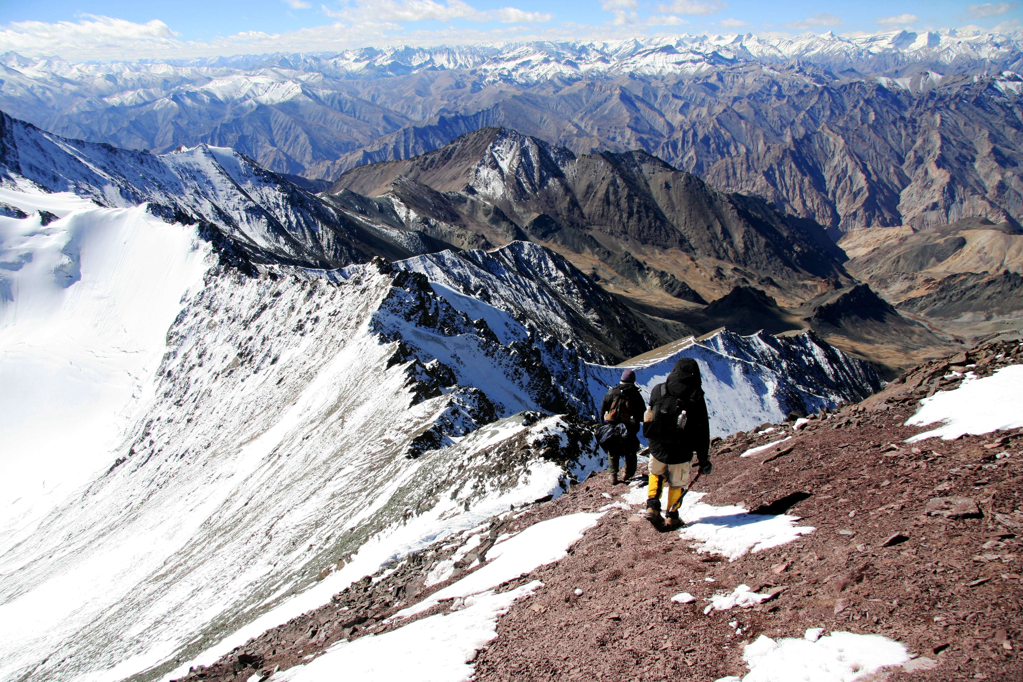
Day 6 — Phurkia to Zero Point and back to Phurkia
- Distance: ~10 km round trip
- Altitude: 3,260 m → 3,820 m → 3,260 m
- Walk time: 5–6 hours round trip
- Overnight: Phurkia
- The summit day. Start by 6:00 AM to maximise clear weather and avoid afternoon clouds. The trail crosses moraine and boulder fields before arriving at Zero Point — the snout of the Pindari Glacier. The views of Nanda Kot, Nanda Bhanar, and the glacier are the defining experience of the trek. Return to Phurkia for the night.
Day 7 — Phurkia to Dwali or Khati
- Distance: 7–18 km depending on stopping point
- Overnight: Dwali (2,580 m) or Khati (2,194 m)
- A long descent day. Most trekkers push through to Khati for a lower, more comfortable overnight and to reduce Day 8's walk. The forest feels welcoming after days above the treeline.
Day 8 — Khati/Dwali to Song, drive to Kathgodam
- Distance: 22–33 km on foot to Song; then ~220 km by road
- Many groups arrange a vehicle pickup from Loharkhet or Song. Aim to reach Song by early afternoon to catch a shared taxi or pre-arranged vehicle back to Kathgodam (arrive late evening or overnight if connecting to trains).
Alternate 6-Day Itinerary (Faster Pace)
Fit trekkers with prior high-altitude experience can compress the itinerary by combining stages:
- Day 1: Kathgodam → Loharkhet (drive)
- Day 2: Loharkhet → Dhakuri
- Day 3: Dhakuri → Khati → Dwali
- Day 4: Dwali → Phurkia → Zero Point → Phurkia
- Day 5: Phurkia → Khati
- Day 6: Khati → Song/Loharkhet, drive to Kathgodam
⚠️ Important: Combining Khati–Dwali–Phurkia into a single day (Day 3–4) significantly increases Acute Mountain Sickness (AMS) risk due to rapid altitude gain. This schedule is only suitable for trekkers who have recently completed treks above 3,000 m and are well-acclimatised. Do not attempt this pace if you are new to altitude. See our guide on how to prevent altitude sickness.
When to go
April to June (Pre-Monsoon) — Best Window
This is the prime trekking season. Rhododendrons bloom spectacularly in April and May, snow patches linger on the upper trail adding drama, and the skies are generally clear in the mornings. May and early June offer the most reliable weather. Temperatures at Phurkia and Zero Point can drop to 0°C at night even in May — come prepared.
July to August (Monsoon) — NOT Recommended
The southwest monsoon brings heavy rainfall to Kumaon, making the trail extremely slippery, leeches prevalent below Khati, and landslides a real danger on the road sections near Bageshwar and Song. Several sections of the trail can become impassable. We strongly advise against trekking Pindari during this period.
September to October (Post-Monsoon) — Excellent
The second-best window. Post-monsoon skies are exceptionally clear, offering some of the sharpest views of Nanda Devi, Nanda Kot, and the glacier. The trail is freshly green, temperatures are moderate, and the crowds (such as they are) have thinned from the peak May–June rush. October can turn cold quickly — be prepared for sub-zero nights at Phurkia by mid-October.
November to March (Winter) — Route Blocked
Heavy snowfall closes the upper trail above Khati and the access road beyond Loharkhet is often blocked. The route is not considered viable for standard trekking during these months.
🗓️ TrekYatra's top picks for 2026: Mid-May to mid-June, and the first two weeks of October.
Is this trek right for you?
Overall Grade: Moderate
The Pindari Glacier trek is classified as moderate difficulty. It is one of the best choices for beginner Himalayan trekkers in India who want a genuine glacial experience without technical climbing.
What makes it moderate (not easy):
- Daily distances of 7–16 km on mixed terrain (forest paths, rocky trails, moraine)
- The Loharkhet–Dhakuri climb involves ~866 m of sustained ascent in a single day
- Altitude at Zero Point (3,820 m) is sufficient to cause AMS in unacclimatised individuals
- No rescue vehicles beyond Khati — medical evacuation is on foot or by helicopter
Fitness preparation (4–6 weeks before):
- 30–40 minutes of brisk walking or jogging, 5 days a week
- Stair climbing with a loaded backpack (10–12 kg)
- Day hikes of 15–20 km on weekends to build foot conditioning
- Yoga or stretching to improve hip flexor and knee resilience
Who is this trek suitable for?
- Age range: approximately 12 to 60 years, subject to good general health
- No prior trekking experience required, though any previous hill walking is advantageous
- Not recommended for those with cardiac conditions, severe asthma, or recent surgery without medical clearance
AMS note: Phurkia (3,260 m) and Zero Point (3,820 m) are the two points where altitude sickness is most likely. The gradual ascent profile of this trek naturally assists acclimatisation, but do not rush the schedule.
What permits you need
⚠️ Permit requirements for 2026: The information below reflects our best current knowledge. Permit fees in Uttarakhand are periodically revised by the Forest Department. Verify current rates at the check post before your trek or contact the Uttarakhand Forest Department directly.
Forest Entry Permit — Required
All trekkers entering the Nanda Devi Biosphere Reserve must hold a valid Forest Entry Permit issued by the Uttarakhand Forest Department.
- Where to obtain: Forest check post at Loharkhet (most common) or Song. Permits are not available online as of our last confirmed information — obtain in person.
- Office hours: Typically 8:00 AM to 5:00 PM; arrive early during peak season as queues form.
- Fee (Indian nationals): Approximately ₹150–₹200 per person per day
- Fee (foreign nationals): Higher rate applies; approximately ₹600–₹800 per person per day
- Camera permit: Additional ₹200 approximately for still/video cameras
- Documents required: Original government-issued photo ID (Aadhaar, passport, voter ID). Carry photocopies.
- Duration: Permit covers the full trek duration; specify your intended number of days.
No Restricted Area Permit (RAP) required for Pindari Glacier — unlike the nearby Milam Glacier or Ralam treks which require Inner Line Permits.
See our comprehensive Uttarakhand trek permits guide for permit logistics across all major Kumaon treks.
What this trek will cost you
The Pindari Glacier trek can be done independently (DIY) at moderate cost, or through an organised operator for a fully managed experience.
⚠️ Cost note for 2026: All figures below are estimates based on prevailing rates and may vary with inflation, operator pricing, and seasonal demand. Treat these as planning benchmarks, not fixed quotes.
DIY Total Estimate: ₹8,000–₹12,000 per person (excluding Kathgodam travel)
Guided Package Total: ₹12,000–₹20,000 per person all-inclusive from Kathgodam
DIY vs. Guided Package Cost Comparison
| Cost Item | DIY Cost (INR) | Guided Package |
|---|---|---|
| Transport (Kathgodam–Song–Kathgodam) | ₹1,600–₹2,400 (shared taxi, both ways) | Included |
| Accommodation (7 nights PWD/guesthouse) | ₹1,400–₹4,200 (₹200–₹600/night) | Included |
| Meals (8 days, ~₹300/day) | ₹2,000–₹3,200 | Included |
| Forest Permits (~6 days) | ₹900–₹1,200 | Included |
| Porter (optional, ₹700–₹900/day × 7 days) | ₹4,900–₹6,300 | Included |
| Guide (optional, ₹800–₹1,200/day) | ₹5,600–₹8,400 (if hired) | Included |
| Gear Rental (poles, jacket if needed) | ₹500–₹1,500 | Often included |
| Total (without porter/guide) | ₹5,900–₹11,000 | ₹12,000–₹20,000 |
| Total (with porter, no guide) | ₹10,800–₹17,300 | ₹12,000–₹20,000 |
PWD guesthouses are basic but functional. During peak May–June season, book well in advance — especially Phurkia and Dhakuri rest houses which have limited capacity.
Gear can be rented in Kathgodam or Almora. See our trekking gear checklist for India for a full rental and buying guide.
What to pack
Clothing (layering system is essential):
- Moisture-wicking base layer (top and bottom) × 2
- Fleece or down mid-layer
- Waterproof and windproof shell jacket
- Trekking trousers × 2
- Thermal leggings for Phurkia/Zero Point nights
- Warm gloves and a wool or fleece hat
- Sun hat or cap
- Gaiters (especially useful in spring with snow patches)
- Merino wool or synthetic trekking socks × 4–5 pairs
- Leech socks (if trekking near or during shoulder monsoon months)
Footwear:
- Sturdy, ankle-supporting waterproof trekking boots (broken in before the trek)
- Lightweight camp sandals or flip-flops for guesthouse evenings
Trekking Gear:
- Trekking poles (collapsible, pair)
- 50–60L trekking backpack with rain cover
- Sleeping bag rated to at least -5°C (essential for Phurkia)
- Trekking towel (microfibre)
- Headlamp + spare batteries
- Sunglasses (UV400 or glacier glasses for Zero Point)
- Sunscreen SPF 50+ and lip balm
Health and Safety:
- Personal first-aid kit (blister plasters, antiseptic, bandage, ibuprofen, ORS sachets)
- Water purification tablets or filter
- Diamox (acetazolamide) — consult your doctor before carrying
- Hand sanitiser
- Insect repellent
Documents:
- Original government ID + 2 photocopies
- Permit copies
- Emergency contact list (printed)
Tech:
- Powerbank (10,000 mAh minimum — no charging points above Khati)
- Offline maps downloaded (Maps.me or Google Maps offline)
- Torch/headlamp backup
📦 For the complete gear list with brand suggestions and budget options, see our trekking gear checklist for India.
Staying safe on the mountain
Altitude Sickness (AMS)
The most significant health risk on this trek. The gradual ascent profile helps, but AMS can affect anyone regardless of age or fitness level.
- Use acclimatisation days at Dhakuri (if arriving from lower altitude quickly) and Khati.
- Follow the golden rule: ascend high, sleep low where possible.
- Drink 3–4 litres of water per day.
- Carry Diamox only if prescribed by a doctor — discuss dosage before the trek.
- Symptoms of AMS: persistent headache, nausea, vomiting, loss of coordination, confusion. Descend immediately if these appear.
- See how to prevent altitude sickness for our detailed protocol.
Weather
- Afternoon thunderstorms are common in the Kumaon Himalayas, even in the best months. Always aim to reach your camp by 1:00–2:00 PM.
- Start walking by 6:00 AM on the Zero Point day — morning clarity is your best chance for unobstructed glacier views.
Trail Safety
- Stream crossings on the approach to Dwali and Phurkia can be dangerous during or just after rain. Never cross a swollen glacial stream — wait or turn back.
- The moraine section approaching Zero Point is uneven; use trekking poles and watch your footing on loose rock.
- Leech socks are strongly recommended for any trek between July and September.
Solo Trekking
- The route is well-marked and solo trekking is possible, but carry a printed itinerary and inform the guesthouse manager of your planned next stage each morning.
- Cell coverage is unreliable from Khati onwards. BSNL has the widest network coverage on this route; Jio and Airtel signals are sparse above Khati.
- Download offline maps and save emergency contacts before departing Kathgodam.
Emergency Contacts (verify before travel):
- Bageshwar District Hospital: ~80 km from Song (nearest facility with inpatient care — flagged for verification of current operational status)
- SDRF Uttarakhand (State Disaster Response Force): 9557444486
- District Emergency: 1077 (Uttarakhand)
- Inform your hotel in Kathgodam of your expected return date.
Similar treks to explore
Nubra Valley Trek: Routes, Permits & Best Time (2026)
The Nubra Valley trek is a 65–90 km high-altitude route in Ladakh crossing Khardung La (5,359 m) into a cold-desert valley at 3,048 m, completed in 7 days.
Sham Valley Trek: Complete Beginner's Guide (2026)
The Sham Valley Trek is Ladakh's most beginner-friendly high-altitude trek, reaching a maximum of ~3,700m over 4–5 days.
Stok Kangri Trek: Complete Guide for Climbers
The Stok Kangri trek is a high-altitude mountaineering route in Ladakh, India, reaching a summit of 6,153 metres — one of India's most accessible 6,000m+ peaks.
Common questions answered
The Pindari Glacier trek is graded moderate. It is suitable for reasonably fit beginners with no prior technical climbing experience. Daily walking distances range from 7 to 16 km on well-marked forest and mountain trails. The main challenges are the sustained 866 m climb from Loharkhet to Dhakuri and the altitude at Phurkia (3,260 m) and Zero Point (3,820 m). With 4–6 weeks of basic fitness preparation, most healthy adults can complete this trek comfortably.
Live Conditions
Real-time weather & trail status
Trail Conditions
Crowdsourced reports from trekkers who've done this route
Sign in to add a trip report
Find a Trek Buddy
Connect with trekkers planning the same route
No buddies yet for this trek
Sign in and be the first to post a planning signal.