Why Ranthan Kharak Trek is on every trekker's list
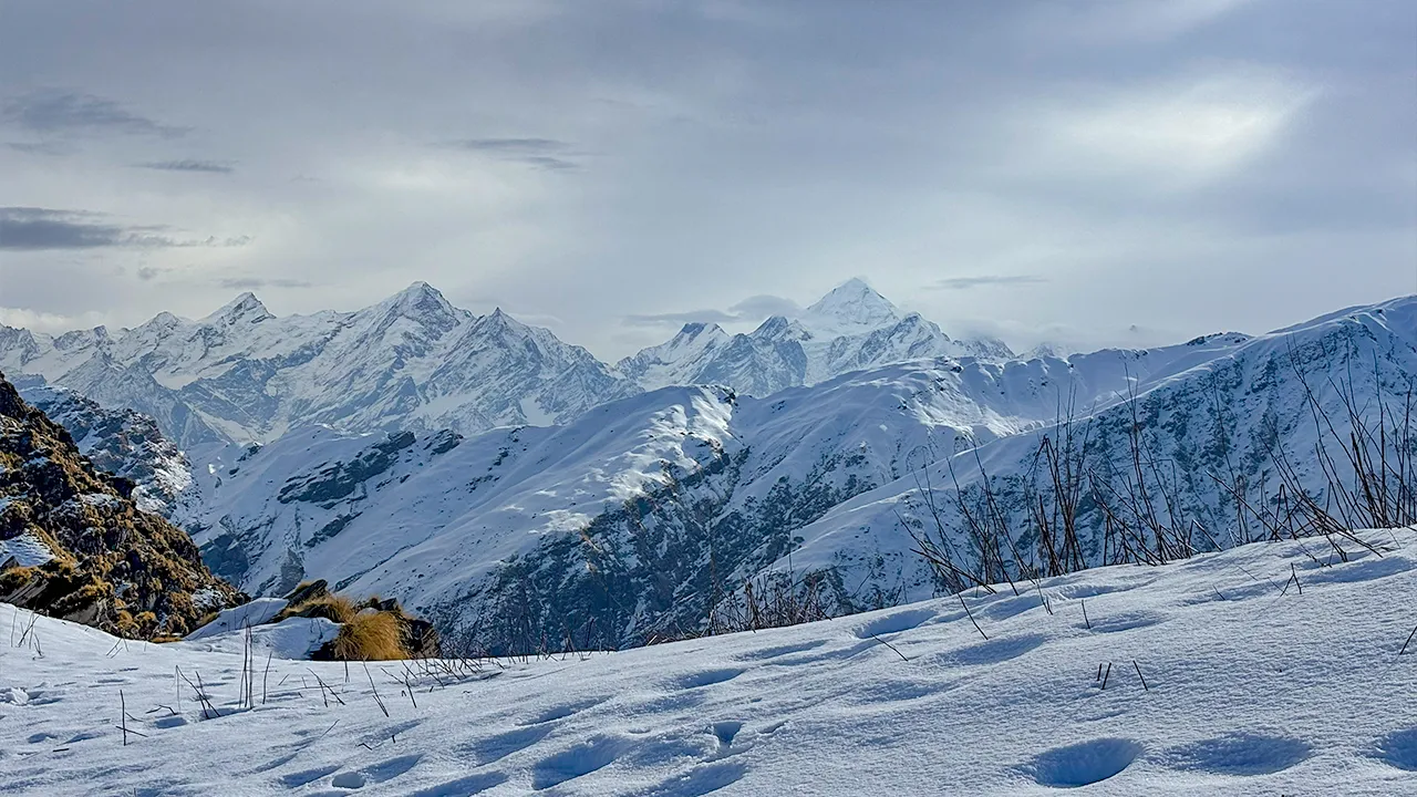
Tucked deep inside the Kedarnath Wildlife Sanctuary in the Garhwal Himalayas, the Ranthan Kharak trek is one of Uttarakhand's most rewarding and least-visited high-altitude adventures. Reaching a maximum altitude of approximately 3,800–4,000 m above sea level, this offbeat trail covers around 25–30 km round trip and winds through dense oak and rhododendron forests, sweeping alpine meadows (bugyals), and open ridgelines with jaw-dropping Himalayan panoramas. If you're a trekker craving solitude, wildlife encounters, and genuine wilderness — far from the overcrowded trails of Kedarnath or Valley of Flowers — Ranthan Kharak deserves a serious look.
In a region famous for pilgrimage routes and heavily trafficked trekking corridors, Ranthan Kharak stands apart. Here's why this trail is earning a devoted following among experienced offbeat trekkers:
Pristine Alpine Meadows with Almost No Crowds
Unlike Chopta or Deoriatal, which see hundreds of trekkers daily during peak season, Ranthan Kharak receives a fraction of that footfall. The meadows here feel genuinely wild — carpeted with wildflowers in summer and burnished gold in October.
Location Inside Kedarnath Wildlife Sanctuary
The trail passes through one of Uttarakhand's most biodiverse protected areas. Snow leopards, Himalayan black bears, musk deer, and a rich array of bird species inhabit this sanctuary. Trekking here is a naturalist's dream.
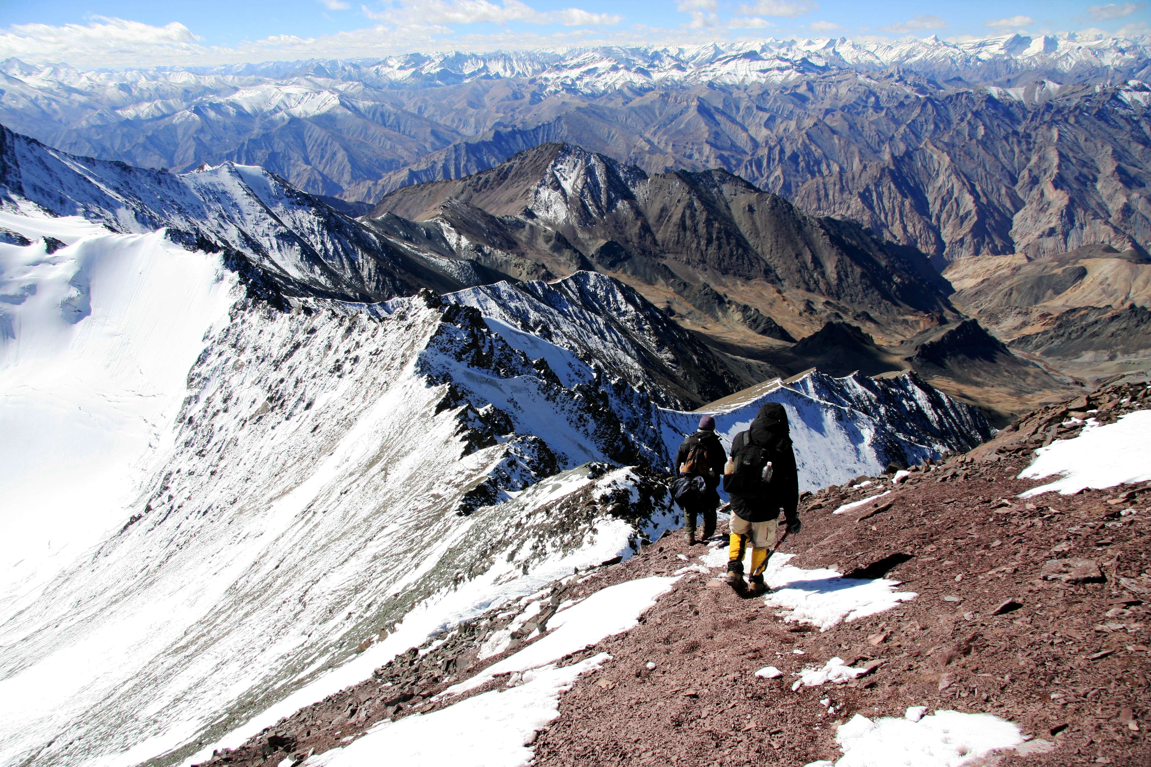
Spectacular Peak Views
From Rohini Bugyal and Ranthan Kharak, on a clear day you can see iconic Himalayan giants including Kedarnath Peak, Chaukhamba (one of Garhwal's most dramatic massifs), and several other peaks of the Gangotri and Kedarnath ranges. The ridgeline views are among the finest in this part of Garhwal.
An Ideal Extension or Alternative
Trekkers who've already done the Deoriatal–Chandrashila trek or the Chopta–Tungnath–Chandrashila route will find Ranthan Kharak a superb next step — familiar enough in approach, yet entirely different in character.
For a curated list of similar routes, see our guide to offbeat treks in Uttarakhand.
At a glance
Ask TrekSage about Ranthan Kharak Trek
Get instant answers grounded in verified trek data — beginner-friendliness, best months, permits, packing, and more.
The route at a glance
The trail typically begins at Sari Village (near Ukhimath) in Rudraprayag district, at an elevation of approximately 1,800 m. From Sari, the route ascends steadily through forested slopes to Deoriatal (~2,438 m), continues upward to the open meadows of Rohini Bugyal (~3,200–3,400 m), and finally reaches the broad alpine pastures of Ranthan Kharak (~3,800–4,000 m).
Total distance: ~25–30 km round trip
Elevation gain: ~2,000–2,200 m from base to highest point
Trail type: Out-and-back with camping at intermediate points
For a visual overview, search for the Ranthan Kharak trek route map — offline maps via apps like Gaia GPS or Maps.me are strongly recommended as the upper trail has no cellular coverage.
Trailhead to Deoriatal
Distance: ~3 km | Elevation gain: ~600 m | Time: 2–3 hours
The trek kicks off from Sari Village, a quiet settlement accessible by road from Ukhimath. The trail immediately enters a mixed forest of oak, rhododendron, and buransh trees. The path is well-worn and moderately steep in places — a solid warm-up that prepares your legs for the days ahead. You'll cross small streams and pass through terraced farmland at the lower sections before the forest closes in. Deoriatal, a serene lake surrounded by conifers, greets you at the top — and on a clear morning, its reflections of Chaukhamba are among the most photographed sights in Garhwal.
Deoriatal to Rohini Bugyal
Distance: ~6–8 km | Elevation gain: ~800–1,000 m | Time: 4–6 hours
This is where the landscape transforms dramatically. Beyond Deoriatal, the trail climbs through progressively thinning forest before breaking out into open alpine terrain. Rohini Bugyal is a series of gently undulating meadows at roughly 3,200–3,400 m, offering your first sweeping views of the high peaks. The gradient is sustained but rarely brutal — long switchbacks through rhododendron scrub give way to open grassy slopes. Look out for musk deer tracks and Himalayan monals (the state bird of Uttarakhand) along this section.
Rohini Bugyal to Ranthan Kharak
Distance: ~4–5 km | Elevation gain: ~400–600 m | Time: 3–4 hours
The final push to Ranthan Kharak is the most dramatic section of the trek. The trail follows the ridge above Rohini Bugyal, climbing steadily through open terrain with almost no tree cover. Wind exposure increases significantly here — pack your hardshell. The meadow at Ranthan Kharak (~3,800–4,000 m) is vast and flat, a high-altitude pasture used by local Gaddi shepherds during summer months. The panoramic views of Kedarnath Peak, Chaukhamba, and surrounding ridges from here are exceptional on clear days. This is the highest point of the trek.
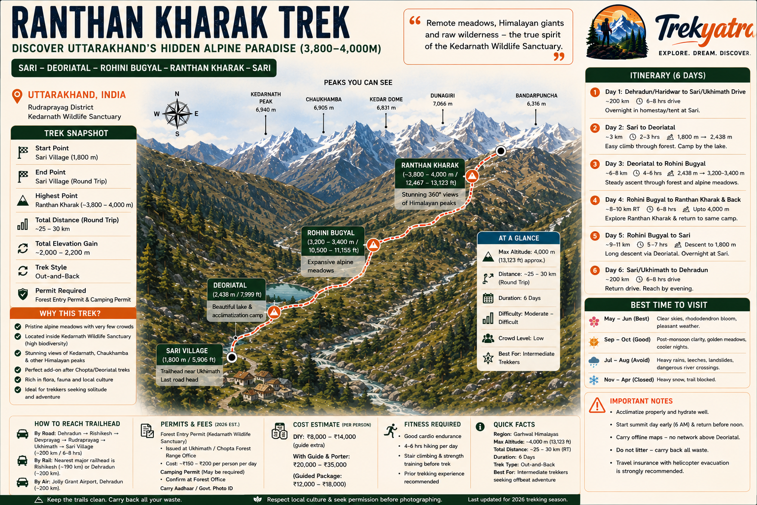
What each day actually looks like
This 6-day itinerary includes the road journey from Dehradun and is designed for trekkers with moderate-good fitness.
Day 1 — Dehradun to Sari/Ukhimath
Drive: ~200 km | Duration: 6–8 hours | Altitude: ~1,300–1,800 m
Depart Dehradun early morning. Route: Dehradun → Rishikesh → Devprayag → Rudraprayag → Ukhimath → Sari Village. The drive through the Garhwal valleys is scenic but winding after Rudraprayag — expect some slow sections. Arrive at Sari by afternoon. Overnight in homestay or tent at Sari. Use the evening to collect permits at the Ukhimath/Chopta Forest Range Office if not already arranged.
Day 2 — Sari to Deoriatal
Trek: ~3 km | Elevation gain: ~600 m | Max altitude: ~2,438 m | Time: 2–3 hours
A short acclimatisation day. Trek up to Deoriatal through forest, set up camp near the lake, and spend the afternoon exploring the lake trail and settling in. The early arrival allows genuine acclimatisation at this altitude before the harder days ahead. Overnight camping at Deoriatal.
Day 3 — Deoriatal to Rohini Bugyal
Trek: ~6–8 km | Elevation gain: ~800–1,000 m | Max altitude: ~3,200–3,400 m | Time: 4–6 hours
An early start is essential. The trail climbs steadily through forest and into open bugyal territory. Rohini Bugyal rewards you with sweeping meadow views and your first clear sightlines to the high peaks. Camp overnight at Rohini Bugyal. Spend the late afternoon acclimatising — short walks around camp rather than resting entirely.
Day 4 — Rohini Bugyal to Ranthan Kharak and Back
Trek: ~8–10 km round trip | Elevation gain/loss: ~400–600 m each way | Max altitude: ~3,800–4,000 m | Time: 6–8 hours
The summit day. Start by 6 AM to maximise clear-sky windows (clouds typically build by early afternoon at this altitude). Push to Ranthan Kharak, spend time taking in the panorama, and begin descent back to Rohini Bugyal for camp. This is the most physically demanding day — pace yourself carefully.
Day 5 — Rohini Bugyal to Sari
Trek: ~9–11 km | Elevation loss: ~1,400–1,600 m | Time: 5–7 hours
Full descent day. The knees will feel the cumulative effort — trekking poles are your best friends today. Back at Sari by early afternoon. Overnight at Sari homestay — a hot meal and a roof feel luxurious after nights under canvas.
Day 6 — Sari/Ukhimath to Dehradun
Drive: ~200 km | Duration: 6–8 hours
Return drive to Dehradun. Reach by evening. Consider a buffer night in Rishikesh if your onward travel is early the next morning.
When to go
Choosing the right season is critical for a safe and rewarding Ranthan Kharak trek experience.
May–June (Best Window — Pre-Monsoon Summer)
This is prime trekking season. Skies are largely clear, rhododendrons are in full bloom at lower elevations, and the bugyals are transitioning from winter snowmelt to lush green. Temperatures at Ranthan Kharak range from around 5°C to 15°C during the day, dropping to 0°C or below at night. Early May may still have snow on the upper sections — a bonus for most trekkers, but check conditions before departing.
July–August (Monsoon — Avoid)
The Southwest Monsoon brings heavy rainfall, turning trails slippery and unpredictable. Landslide risk on the Rudraprayag–Ukhimath road increases substantially. Leeches are prevalent in the lower forest sections. Stream crossings that are minor obstacles in May become genuinely hazardous. We strongly advise against trekking Ranthan Kharak during this period.
September–October (Second Best Window — Post-Monsoon)
Post-monsoon is arguably the most visually dramatic time to trek here. The atmosphere is crisp and washed clean, visibility extends to distant peaks, and the meadows turn warm amber and gold. Temperatures drop faster as October progresses — expect sub-zero nights by mid-October at Rohini Bugyal and above. Bring your warmest sleeping bag.
November–April (Winter — Experts Only)
The upper sections receive heavy snowfall from November onwards. Rohini Bugyal and Ranthan Kharak are typically buried under deep snow by December and remain so until March or April. Only experienced mountaineers with full winter camping gear, navigation skills, and avalanche awareness should attempt this route in winter.
Our pick for 2026 trekking season: Target the first two weeks of June or the last two weeks of September for the optimal balance of weather, visibility, and trail conditions.
Is this trek right for you?
Difficulty Rating: Moderate–Difficult
Do not let the relatively modest maximum altitude fool you — Ranthan Kharak is a genuinely demanding trek. Key factors elevating its difficulty:
- Sustained ascents: The climb from Deoriatal to Rohini Bugyal involves several hours of unrelenting uphill on remote trail
- Altitude above 3,500 m: The final section pushes into territory where altitude sickness is a real risk for those who ascend too quickly
- Remote trail: No rescue infrastructure, limited mobile connectivity, and no teahouses beyond Deoriatal — you carry what you need
- Variable weather: Afternoon storms are common even in the best seasons
Fitness Preparation (4–6 weeks before the trek):
- Cardiovascular training: Running, cycling, or swimming 4–5 days per week
- Stair climbing with a loaded pack (10–12 kg)
- Practice hikes of 10–15 km with elevation gain
- Yoga or stretching to improve flexibility and reduce injury risk
Suitable for: Fit beginners with solid hiking experience (prior overnight treks recommended), intermediate and experienced trekkers.
Not suitable for: Individuals with cardiac or respiratory conditions, children under 14 without medical clearance and experienced adult supervision, anyone who has not trekked above 2,500 m before without prior preparation.
What permits you need
Permits are mandatory for the Ranthan Kharak trek. The trail passes through the Kedarnath Wildlife Sanctuary, a protected area managed by the Uttarakhand Forest Department, and entry without a permit is illegal.
Forest Entry Permit — Kedarnath Wildlife Sanctuary
- Where to obtain: Ukimath/Chopta Forest Range Office (physical collection only — no online portal as of 2026)
- Cost: Approximately INR 150–200 per person per day (⚠️ 2026 rates not independently verified; confirm at the Range Office before departure)
- Documents required: Government-issued photo ID (Aadhaar card strongly recommended), one passport-size photograph
- Validity: Issued per day of sanctuary entry — factor in all trekking days
Camping Permit
A separate camping permit may be required for overnight stays within sanctuary boundaries, particularly at Rohini Bugyal. (⚠️ Camping permit requirement and cost needs confirmation at Range Office)
Foreigners / International Trekkers
Foreign nationals must carry their passport and Indian visa. Additional Inner Line Permit requirements should be verified with the Forest Range Office and Uttarakhand Tourism prior to the trek, as regulations in wildlife sanctuary zones can change.
Practical tip: Arrive at the Range Office early on Day 1 of your trek (or the evening before) — the office may have limited operating hours and queues during peak season. For a broader overview of trekking permit processes in Uttarakhand, see our complete permit guide.
What this trek will cost you
DIY Trek Budget (Per Person, 6 Days)
| Item | Estimated Cost (INR) |
|---|---|
| Transport: Dehradun to Sari (bus) | 500–800 |
| Transport: Dehradun to Sari (shared taxi) | 1,500–2,000 |
| Transport: Dehradun to Sari (private taxi) | 3,000–4,500 |
| Forest entry permits (5 days @ ~INR 150–200/day) | 750–1,000 |
| Camping gear rental (if needed, ~INR 500/day) | 2,000–2,500 |
| Food & supplies (self-catered, ~INR 500–700/day) | 3,000–4,200 |
| Local guide (recommended, ~INR 1,000–1,500/day) | 5,000–7,500 |
| Porter (optional, ~INR 800–1,200/day) | 4,000–6,000 |
| DIY Total (guide, no porter, bus transport) | ~INR 8,000–14,000 |
(⚠️ All cost figures subject to change in 2026 season)
Organised Package
INR 12,000–18,000 per person for a 6-day organised trek including transport from Dehradun, permits, guide, camping equipment, and meals. (⚠️ Operator pricing varies significantly; obtain current quotes from operators)
Organised packages make sense if you lack camping equipment, prefer guided navigation, or are trekking solo — the guide cost alone justifies it for many. Always verify that the package explicitly covers sanctuary permits.
🎒 Gear up smart: See our editors' picks for the best trekking boots in India before your trek. [Affiliate product card — trekking boots, sleeping bags, trekking poles]
What to pack
Packing correctly for Ranthan Kharak is non-negotiable — you'll be camping above 3,000 m with no resupply points beyond Sari. Travel light, but don't compromise on warmth or safety.
Clothing & Layering
- Base layer: Moisture-wicking synthetic or merino wool top and bottom (avoid cotton entirely)
- Mid layer: Fleece jacket or down sweater — essential above 3,000 m even in summer
- Outer/shell layer: Waterproof and windproof hardshell jacket and trousers
- Thermal innerwear: For cold nights at Rohini Bugyal and Ranthan Kharak
- Trekking trousers: Quick-dry, ideally with zip-off option
- Gloves: Thin liner gloves + waterproof outer gloves
- Balaclava or warm hat: Critical for summit day wind exposure
- Sun protection: UV-blocking sunglasses (glacier spec), wide-brim hat, SPF 50+ sunscreen
- Gaiters: Useful in early May (snow) and post-monsoon (mud)
- Rain cover / poncho: For sudden afternoon showers
Camping & Shelter Gear
- Tent: Three-season or four-season tent capable of handling wind — freestanding preferred
- Sleeping bag: Rated to at least -5°C (comfort rating); -10°C recommended for October trekking
- Sleeping mat: Insulated foam or inflatable pad — do not skip this
- Headlamp: LED headlamp with at least 200 lumens; carry spare batteries (cold kills battery life fast)
- Trekking poles: Highly recommended for the sustained descents
- Stuff sacks / dry bags: Keep sleeping bag and clothing dry in pack
Health & Medications
- Diamox (Acetazolamide): Consult your doctor before the trek — widely used for AMS prevention above 3,000 m; carry if prescribed
- ORS sachets: At least 10; critical for rehydration
- Blister kit: Moleskin, antiseptic, bandages
- Pain relief: Ibuprofen or paracetamol
- Antihistamine: For allergic reactions
- Water purification: Iodine tablets or a reliable filtration bottle (e.g., LifeStraw)
- HACE/HAPE awareness: Know the symptoms — severe headache, ataxia, wet cough. Descend immediately and seek help. See our altitude sickness prevention guide.
- Personal prescription medications: Sufficient supply plus a 2-day buffer
Documents & Admin
- Aadhaar/passport (original + photocopy)
- Sanctuary permits (carry physical copies)
- Travel insurance documentation (ensure policy covers high-altitude trekking)
- Emergency contact list
- Offline maps downloaded to phone + physical map if available
[Affiliate product card — sleeping bags, trekking poles, water filters]
Staying safe on the mountain
Ranthan Kharak's remote location and altitude demand rigorous safety awareness. Follow these guidelines — they could save your life.
Acclimatise Properly
Do not rush the ascent. The itinerary above is designed with acclimatisation built in — respect it. Never ascend more than 500 m of sleeping altitude gain per day above 3,000 m. The Day 2 rest at Deoriatal is not optional fluff; it's physiological preparation.
Recognise Acute Mountain Sickness (AMS)
Symptoms include persistent headache, nausea, dizziness, fatigue, and poor sleep. If symptoms worsen or you develop confusion, loss of coordination (HACE), or a wet cough with breathlessness at rest (HAPE), descend immediately. Do not wait to see if symptoms improve at altitude.
Weather Monitoring
Check forecasts before each day's climb — mountain weather can deteriorate rapidly. If dark clouds build before noon, consider turning back from the summit push. Lightning on open ridgelines is lethal. Carry a reliable weather app (Mountain Forecast or Windy) with data downloaded offline.
No Solo Camping Rule
The Kedarnath Wildlife Sanctuary is active wildlife territory. Bears and leopards are present. Never camp alone, and store food properly away from your tent. Trekking solo above Deoriatal without a local guide is strongly discouraged — the trail markers thin out significantly beyond Rohini Bugyal.
Stream Crossings
In May and early June, snowmelt swells streams considerably. Use trekking poles for balance, unbuckle your pack hipbelt before crossing, and never cross a stream that reaches above your knees without a guide's assessment.
Emergency Contacts
- Ukimath Forest Range Office: (contact number — flagged for review, confirm locally)
- Uttarakhand Tourism Helpline: 1364
- Nearest hospital: Ukhimath PHC (basic), Rudraprayag District Hospital (~2 hours from Sari by road)
- Police: 112
Satellite Communicator
For groups trekking without a fixed operator, a satellite communicator (Garmin inReach or similar) is strongly recommended. There is no mobile coverage above Deoriatal on most networks.
Similar treks to explore
Nubra Valley Trek: Routes, Permits & Best Time (2026)
The Nubra Valley trek is a 65–90 km high-altitude route in Ladakh crossing Khardung La (5,359 m) into a cold-desert valley at 3,048 m, completed in 7 days.
Sham Valley Trek: Complete Beginner's Guide (2026)
The Sham Valley Trek is Ladakh's most beginner-friendly high-altitude trek, reaching a maximum of ~3,700m over 4–5 days.
Stok Kangri Trek: Complete Guide for Climbers
The Stok Kangri trek is a high-altitude mountaineering route in Ladakh, India, reaching a summit of 6,153 metres — one of India's most accessible 6,000m+ peaks.
Common questions answered
The highest point of the Ranthan Kharak trek is the Ranthan Kharak meadow itself, situated at approximately 3,800–4,000 m above sea level. The exact figure varies slightly across sources, and the specific ridgeline or meadow edge where altitude is measured differs by route. Trekkers should treat this as a genuine high-altitude environment and acclimatise accordingly.
Live Conditions
Real-time weather & trail status
Trail Conditions
Crowdsourced reports from trekkers who've done this route
Sign in to add a trip report
Find a Trek Buddy
Connect with trekkers planning the same route
No buddies yet for this trek
Sign in and be the first to post a planning signal.