Why Rupin Pass Trek is on every trekker's list
In a range full of spectacular high-altitude treks, Rupin Pass stands apart for the sheer variety it packs into a single route. Within six trekking days you move through oak and rhododendron forests, open meadows carpeted with wildflowers (in May–June), remote Kinnauri villages, sheer canyon walls carved by the Rupin River, and finally the vast snowfields that guard the pass itself.
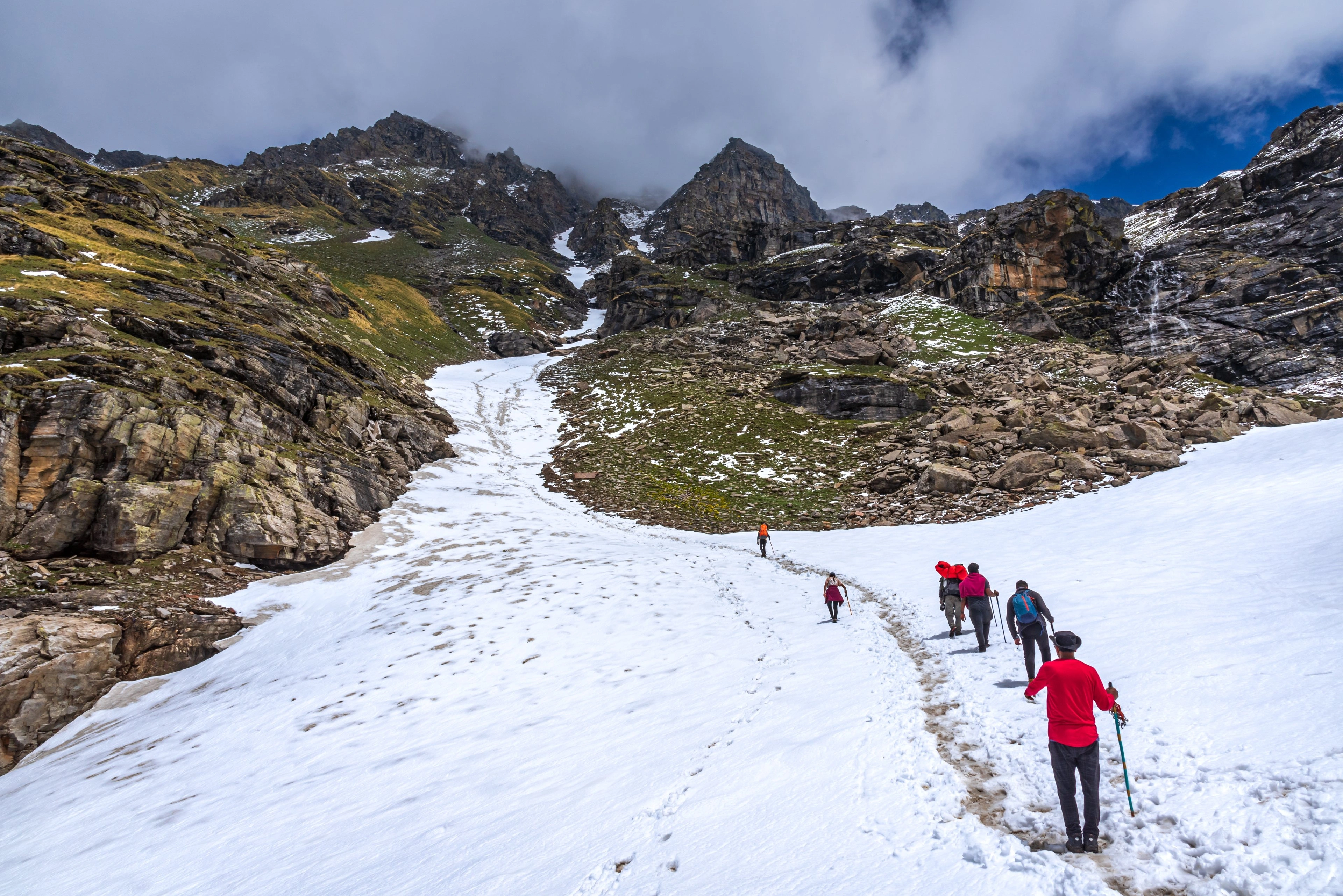
The iconic hanging waterfall — a multi-tiered cascade that appears to hang suspended from the cliff face — is perhaps the single most photographed natural feature on any Himalayan trek in North India. Trekkers camp at its base and wake to the sound of the falls echoing off the valley walls. Higher still, the snow bridge crossing is a genuine alpine experience that even seasoned trekkers find exhilarating.
Other reasons to choose Rupin:
- Cross-state journey — you begin in Uttarakhand and finish in Himachal Pradesh, genuinely crossing the Great Himalayan Range.
- Manageable group sizes — the trail is less crowded than Kedarkantha or Triund, especially in early season.
- Photography — the waterfall, snow bridge, and high-altitude snow bowl offer world-class compositions.
- Sense of accomplishment — the Difficult grade means completing it genuinely sets you apart.
- Remote villages — Jiskun and Dhaula offer authentic Kinnauri culture rarely seen on more commercialised trails.
What Makes Rupin Pass Unique Among Himalayan Treks?
Compare Rupin to other popular routes:
| Trek | Max Altitude | Waterfalls | Snow Bridge | Cross-State | Difficulty |
|---|---|---|---|---|---|
| Rupin Pass | 15,250 ft | Yes (iconic) | Yes | Yes (UK→HP) | Difficult |
| Kedarkantha | 12,500 ft | No | No | No | Moderate |
| Hampta Pass | 14,100 ft | No | No | Yes (HP→Lahaul) | Moderate–Difficult |
Kedarkantha is a perfect first high-altitude trek; Hampta Pass gives you the dramatic Spiti contrast. But Rupin Pass combines waterfalls at multiple altitudes, a genuine snow bridge, remote villages, and a demanding summit day that rewards only those who have prepared properly. There is nothing quite like it in the Indian Himalayan calendar.
At a glance
Ask TrekSage about Rupin Pass Trek
Get instant answers grounded in verified trek data — beginner-friendliness, best months, permits, packing, and more.
The route at a glance
The trail follows the Rupin River upstream from Dhaula before climbing steeply through a series of waterfalls, gorges, and snowfields to the pass, then descending into the Sangla Valley on the Himachal Pradesh side.
Full route: Dhaula (5,200 ft) → Sewa → Jiskun (7,900 ft) → Udaknal (10,800 ft) → Lower Waterfall Camp (11,300 ft) → Upper Waterfall Camp (12,600 ft) → Snow Bridge → Rupin Pass (15,250 ft) → Sangla (9,100 ft)
Total distance: ~52 km | Elevation gain: ~10,050 ft
Simplified elevation profile:
15,250 ft |                              *  (Rupin Pass)
14,000 ft |                           *
12,600 ft |                      *  (Upper Waterfall Camp)
11,300 ft |                 *  (Lower Waterfall Camp)
10,800 ft |           *  (Udaknal)
 7,900 ft |      *  (Jiskun)
 5,200 ft | *  (Dhaula)
           Day1  Day2  Day3  Day4  Day5  Day6  Day7
Key landmarks on the trail include: the Rupin River gorge below Jiskun (a dramatic slot canyon section), the lower waterfall view camp, the hanging waterfall (the trail passes directly beneath it), the snow bowl between the upper camp and the pass, and the final rocky ascent to the pass cairn with views into Kinnaur.
Where Does the Rupin Pass Trek Start and How Do You Get There?
The vast majority of trekkers start from Dhaula, a small village in Uttarkashi district, Uttarakhand. Dhaula sits at the roadhead where the motorable track ends, and the forest check post here is where you collect your permit.
How to reach Dhaula from Dehradun: The drive covers approximately 200 km and takes 8–10 hours depending on road conditions. The route goes via Vikas Nagar, Nainbagh, and Naith. From Naith, a rough mountain road leads to Dhaula. There is no direct bus to Dhaula — travellers take a bus or shared cab to Naith and arrange a local cab onward. For full transport logistics, see our Dehradun to Dhaula travel guide.
Exit point: The trek ends at Sangla in Kinnaur district, Himachal Pradesh, from where buses and shared cabs run to Shimla (~5–6 hours) and onward to Chandigarh.
Note: Some operators offer an alternative start from Rohru (Himachal Pradesh), tackling the route in reverse from Sangla to Dhaula. This is less common and reverses the natural elevation gain logic.
Rupin Pass Trek Distance and Elevation Profile
| Day | Section | Distance | Start Alt | End Alt |
|---|---|---|---|---|
| 1 | Dehradun → Dhaula (drive) | ~200 km | 2,200 ft | 5,200 ft |
| 2 | Dhaula → Jiskun | ~11 km | 5,200 ft | 7,900 ft |
| 3 | Jiskun → Udaknal | ~10 km | 7,900 ft | 10,800 ft |
| 4 | Udaknal → Lower Waterfall Camp | ~6 km | 10,800 ft | 11,300 ft |
| 5 | Lower → Upper Waterfall Camp | ~4 km | 11,300 ft | 12,600 ft |
| 6 | Upper Camp → Pass → Sangla | ~14 km | 12,600 ft | 9,100 ft |
| 7 | Sangla rest / buffer day | — | — | — |
| 8 | Sangla → Shimla/Chandigarh (drive) | ~230 km | 9,100 ft | — |
Rupin Pass base camp altitude: The upper waterfall camp at approximately 12,600 ft functions as the de facto base camp for the summit push. Rupin Pass altitude: 15,250 ft (4,650 m).
What each day actually looks like
Day 1: Dehradun to Dhaula (Drive)
Distance: ~200 km | Duration: 8–10 hours | End altitude: 5,200 ft
Depart Dehradun early morning (5–6 AM) to maximise daylight. The road passes through Vikas Nagar and the scenic Tons Valley before reaching Naith. Beyond Naith, the road to Dhaula is narrow and unpaved in sections — expect dust and some bumps. Arrive Dhaula by afternoon, check in to a homestay, register at the forest check post and collect your permit. Rest and hydrate well.
Difficulty: None (travel day) | Accommodation: Homestay in Dhaula (₹300–₹600/night)
Day 2: Dhaula to Jiskun
Distance: ~11 km | Elevation gain: ~2,700 ft | End altitude: 7,900 ft | Duration: 5–6 hours
The trail begins gently through oak and rhododendron forest along the Rupin River. You pass through the small village of Sewa before arriving at Jiskun, the last permanently inhabited village on the Uttarakhand side. Jiskun offers homestay accommodation and a chance to buy local snacks. The gorge section near Jiskun — where the river cuts through sheer rock walls — is one of the trail's most dramatic passages.
Difficulty: Easy–Moderate | Accommodation: Homestay or camping
Day 3: Jiskun to Udaknal
Distance: ~10 km | Elevation gain: ~2,900 ft | End altitude: 10,800 ft | Duration: 6–7 hours
This is where the trail steepens noticeably. You leave the tree line behind and enter open meadows. Udaknal is a high meadow campsite with views of the surrounding peaks. Altitude begins to be felt here — move slowly, drink water, and watch for early AMS symptoms.
Difficulty: Moderate | Accommodation: Camping only
Day 4: Udaknal to Lower Rupin Waterfall Camp
Distance: ~6 km | Elevation gain: ~500 ft | End altitude: ~11,300 ft | Duration: 3–4 hours
A shorter day by design — this is your primary acclimatisation day. The trail continues through open meadows and you get your first views of the Rupin waterfall ahead. Camp is set up near the base of the falls. In the afternoon, do a short acclimatisation walk up toward the waterfall and return to camp. The sound and sight of the hanging waterfall from camp is one of the trek's defining memories.
Difficulty: Easy | Accommodation: Camping only
Day 5: Lower Waterfall Camp to Upper Waterfall Camp
Distance: ~4 km | Elevation gain: ~1,300 ft | End altitude: ~12,600 ft | Duration: 4–5 hours
The trail climbs steeply past the lower falls, skirting the cliff face to reach the hanging waterfall section. In May–June, this section involves climbing alongside frozen waterfalls with ice axes and crampons in some years — your guide's assessment of conditions on the day is critical. The upper waterfall camp sits in a dramatic bowl surrounded by snow walls. Rest here for the summit push tomorrow.
Difficulty: Difficult | Accommodation: Camping only
Day 6: Upper Waterfall Camp → Snow Bridge → Rupin Pass → Sangla (Summit Day)
Distance: ~14 km | Elevation gain/loss: +2,650 ft to pass, then −6,150 ft to Sangla | End altitude: 9,100 ft | Duration: 10–12 hours
The longest and most demanding day. Start at 3–4 AM — the snow bridge is safest to cross in early morning when temperatures are lowest and the snow is firm. The route climbs steeply through the snow bowl to the snow bridge, a narrow traverse that can feel exposed; cross one at a time and follow your guide's instructions precisely. From the bridge, a final steep push of 2–3 hours reaches the pass at 15,250 ft. The views from the top span both Uttarakhand's Tons Valley and Himachal's Kinnaur range. The descent to Sangla is long and knee-testing — use trekking poles. Arrive Sangla by evening.
Difficulty: Very Difficult | Accommodation: Guesthouse in Sangla
Day 7: Rest Day in Sangla (Buffer / Exploration)
Altitude: 9,100 ft
This day functions as a buffer in case summit day is delayed by weather, and as a well-earned rest day if all goes to plan. Sangla is a beautiful apple-orchard valley — explore the local bazaar, visit the Kamru Fort, or take a day trip to Chitkul (18 km from Sangla). Celebrate your summit.
Difficulty: Rest day | Accommodation: Guesthouse in Sangla
Day 8: Sangla to Shimla or Chandigarh (Drive)
Distance: ~230 km to Shimla | Duration: 5–7 hours
Shared cabs and buses from Sangla connect to Shimla via Rohru and the Sutlej Valley. From Shimla, onward connections to Chandigarh, Delhi, and Dehradun are plentiful.
How Many Acclimatisation Days Does the Rupin Pass Trek Require?
The itinerary above builds in natural acclimatisation on Day 4 (the short walk to Lower Waterfall Camp), but the elevation gain from Day 2 to Day 5 is substantial. If any trekker shows symptoms of Acute Mountain Sickness (AMS) — persistent headache, nausea, vomiting, loss of coordination, or extreme fatigue — an extra rest day at Udaknal or Lower Waterfall Camp is strongly recommended before proceeding.
Golden rule: Never ascend with AMS symptoms. The only treatment for worsening AMS is immediate descent.
When to go
| Season | Months | Conditions | Recommended? |
|---|---|---|---|
| Pre-monsoon | Mid-May – mid-June | Snow bridges intact, wildflowers, dramatic landscapes | ✅ Best window |
| Monsoon | July – August | Heavy rain, landslides, flooded trails | ❌ Avoid |
| Post-monsoon | Late September – mid-October | Clear skies, autumn colors, less snow | ✅ Good window |
| Winter | November – April | Pass closed, heavy snowfall | ❌ Closed |
Best overall windows: mid-May to mid-June and late September to mid-October.
May–June is the classic window. The snow bridges are at their thickest, the hanging waterfall is in full thunderous flow fed by snowmelt, rhododendrons and other wildflowers carpet the meadows, and the dramatic snow bowl scenery is at its most photogenic. Expect cold nights (−5°C to −10°C at upper camps) and warm days.
September–October offers crystal-clear post-monsoon skies, autumn colours in the oak and maple forests, and significantly less snow on the trail (the snow bridge may be thinner or absent late in the season — verify conditions before booking). Temperatures are colder by October.
July–August: The Tons and Rupin valleys receive significant monsoon rainfall. Trails become slippery, river crossings dangerous, and the risk of landslides on the approach road from Naith is real. Operators routinely cancel departures in this period. Avoid.
Is this trek right for you?
Grade: Difficult — This trek is not suitable for first-time trekkers or those without prior high-altitude experience.
What makes it difficult:
- Sustained elevation gain to 15,250 ft
- Steep snow slopes requiring crampons and ice axe use on summit day (in season)
- 10–12 hour summit day with significant vertical gain and descent
- Average daily distance of 8–11 km with a loaded pack
- No rescue infrastructure above Jiskun — evacuation requires helicopter or stretcher carry
Minimum fitness standard: You should be comfortable walking 15–20 km/day with a 8–10 kg pack before attempting this trek.
Who should NOT attempt Rupin Pass:
- Anyone with heart conditions, high blood pressure, or respiratory issues
- Trekkers with no prior experience above 10,000 ft
- Children under 14 years of age
- Anyone who cannot commit to 4–6 weeks of pre-trek training
For comparison: Kedarkantha (Moderate) is an excellent stepping stone. If you have done Kedarkantha or a similar moderate Himalayan trek and want the next challenge, Rupin Pass is a natural progression.
Training Plan for Rupin Pass Trek
4-week minimum training outline:
- Weeks 1–2: Cardiovascular base — 45-minute runs or brisk walks 5 days/week, cycling, swimming. Focus on aerobic capacity.
- Weeks 3–4: Strength and endurance — stair climbing or hill walks with a 8–10 kg backpack, 1–1.5 hours per session, 4 days/week. Add lunges, squats, and calf raises for leg strength.
- Throughout: Yoga or stretching (15 minutes daily) for hip flexors, hamstrings, and ankles — critical for steep downhill sections.
For a detailed programme, see our high-altitude trek training guide.
What permits you need
Rupin Pass trek covers ~52 km through Uttarakhand and Himachal Pradesh, reaching 15,250 ft (4,650 m) via a hanging waterfall, snow bridge, and dramatic snow bowl — graded Difficult, best done mid-May to mid-June or late September to mid-October.
At 15,250 feet (4,650 m) above sea level, the Rupin Pass is not merely a mountain crossing — it is a cinematic journey that earns every step of its reputation. Straddling the border of Uttarakhand and Himachal Pradesh, this roughly 52 km trail begins in the quiet hamlet of Dhaula on the banks of the Rupin River and ends in the breathtaking Sangla Valley, with Chitkul — India's last inhabited village near the Indo-Tibetan border — within easy reach.
What makes the Rupin Pass trek famous is not just its altitude. It is the impossible sight of a hanging waterfall that appears to pour out of the mountainside into thin air, the heart-stopping traverse of a snow bridge in the pre-dawn dark, and the sudden revelation of a snow bowl that forms a natural amphitheatre below the pass. These images are the reason Rupin Pass consistently ranks among India's top 25 treks and appears on countless top-10 Himalayan trek lists.
This guide is written for the 2026 trekking season and covers everything: the day-wise itinerary, how to reach the starting point from Dehradun, permit requirements, realistic cost estimates, a complete packing list, safety protocols, and the best months to go. Whether you are planning a DIY trip or evaluating an organised package, read this before you lace up your boots.
A forest permit is mandatory for the Rupin Pass trek.
- Issuing authority: Uttarakhand Forest Department
- Where to obtain: At the Dhaula forest check post on arrival, or in advance through the Uttarakhand forest department's online portal (check the official portal as online booking availability can change)
- Cost: Approximately ₹150–₹200 per person per day
- Total permit cost per person for ~7 trekking days: approximately ₹1,050–₹1,400
- Documents required: Original government-issued photo ID (Aadhaar card, passport, or driving licence). Carry photocopies as well.
- Inner Line Permit: As of the latest available information, an Inner Line Permit (ILP) is not required for this trek. However, this can change — verify 30 days before your departure, especially for the Himachal Pradesh (Kinnaur) side near Sangla, which has historically had ILP requirements for certain zones. See our Uttarakhand trek permits guide for updated information.
- Himachal Pradesh entry (Sangla/Kinnaur): Foreign nationals require a Protected Area Permit (PAP) for Kinnaur district. Indian nationals generally do not require a separate permit but should carry ID.
⚠️ Permit rules change. Always verify requirements 30 days before your trek date.
What this trek will cost you
DIY Rupin Pass Trek Cost (Per Person)
| Item | Estimated Cost (₹) |
|---|---|
| Dehradun → Dhaula (shared cab via Naith) | ₹800 – ₹1,200 |
| Sangla → Shimla (shared cab/bus) | ₹600 – ₹900 |
| Forest permit (~7 days × ₹150–₹200) | ₹1,050 – ₹1,400 |
| Camping gear rental (tent, sleeping bag, etc.) | ₹400 – ₹600/day × 6 nights = ₹2,400–₹3,600 |
| Food on trail (self-cooked/local) | ₹350–₹500/day × 7 days = ₹2,450–₹3,500 |
| Porter (optional but recommended) | ₹1,000–₹1,200/day × 6 days = ₹6,000–₹7,200 |
| Homestays (Dhaula + Jiskun + Sangla) | ₹300–₹600/night × 3 nights = ₹900–₹1,800 |
| Total DIY (without porter) | ₹7,200 – ₹12,400 |
| Total DIY (with porter) | ₹13,200 – ₹19,600 |
Note: Gear rental costs assume you do not own trekking equipment. If you own a sleeping bag and poles, costs drop significantly.
Organised Package Cost (Per Person)
| Operator Type | Estimated Package Cost (₹) | Inclusions |
|---|---|---|
| Mid-range operators (e.g., Indiahikes, Trek The Himalayas) | ₹14,000 – ₹22,000 | Transport (Dehradun pickup), permits, camping, meals, guide, porter, first aid |
| Budget local operators | ₹10,000 – ₹14,000 | Basic camping, guide, meals — verify inclusions carefully |
All cost figures are estimates for the 2026 season and are subject to change. Confirm operator pricing directly before booking.
What to pack
Clothing
- Moisture-wicking base layer (top and bottom) × 2
- Mid-layer fleece or down jacket
- Waterproof and windproof outer shell jacket
- Trekking pants (quick-dry) × 2
- Warm hat / balaclava
- Sun hat or cap
- Gloves (inner liner + waterproof outer)
- Thermal socks × 3–4 pairs, woollen socks × 2 pairs
- Gaiters (essential for snow sections)
Footwear
- Crampon-compatible trekking boots (ankle support, waterproof) — see our best trekking boots guide
- Camp sandals or lightweight shoes
- Crampons (operator may provide; confirm in advance)
Gear
- 50–60L backpack with rain cover
- Trekking poles × 2 (critical for snow sections and long descents) — see our buying guide
- Headlamp + spare batteries (essential for 3 AM summit start)
- Sleeping bag rated to −10°C (do not compromise on this)
- Sleeping mat (if not provided by operator)
- Trekking towel (microfibre)
- Sunglasses (UV400, wraparound)
- Sunscreen SPF 50+ and lip balm
- Water bottles × 2 (1 litre each) + water purification tablets or filter
- Tiffin box / reusable cutlery
Documents
- Government-issued photo ID (original + 2 photocopies)
- Forest permit (keep in waterproof bag)
- Travel insurance documents (with helicopter evacuation cover)
- Emergency contact list (printed)
Medication
- Diamox (Acetazolamide) — consult your doctor before the trek; standard prophylactic dose is 125–250 mg twice daily starting 24 hours before ascent (consult a physician — do not self-prescribe)
- Paracetamol / ibuprofen
- Oral rehydration salts (ORS)
- Blister kit (moleskin, antiseptic, bandages)
- Antifungal and antibiotic cream
- Personal prescription medications
Electronics
- Power bank (20,000 mAh minimum — no charging points above Jiskun)
- Camera + extra batteries (cold drains batteries fast)
- Phone (offline maps downloaded — maps.me or Google Maps offline)
Staying safe on the mountain
General Safety
- Start summit day at 3–4 AM. The snow bridge and upper slopes are safest when temperatures are lowest and snow is firm. Post-noon, snowmelt makes crossings dangerous.
- Never cross the snow bridge alone. Cross one person at a time. Follow guide instructions precisely.
- Check weather the night before summit day. If your guide reports an incoming storm or poor visibility forecast, delay by 24 hours.
- Above Jiskun, there are NO teahouses or dhabas. All food and shelter is camping-based. Carry sufficient supplies.
- Solo trekking above Jiskun is strongly discouraged due to snow terrain, navigation difficulty, and no rescue infrastructure. Join a group or hire a local guide.
Emergency Contacts
- SDRF Uttarakhand Helpline: 1077
- Nearest hospital: Rohru Civil Hospital, Himachal Pradesh (for trekkers evacuated via the Sangla side)
- Travel insurance with helicopter evacuation is strongly recommended — a helicopter rescue from the pass area can cost ₹1.5–₹3 lakh without insurance. (Cost estimate flagged for review)
Accommodation Note
Homestays are available in Dhaula (₹300–₹600/night) and Jiskun (₹300–₹500/night). Above Jiskun, all accommodation is tent camping — either self-carried or operator-provided. Book Dhaula and Jiskun homestays in advance for the May–June peak season.
How Do You Prevent and Treat Altitude Sickness on the Rupin Pass Trek?
AMS symptoms to watch for:
- Persistent headache not relieved by paracetamol
- Nausea or vomiting
- Dizziness or loss of balance
- Fatigue disproportionate to exertion
- Shortness of breath at rest
- Confusion or altered mental state (severe — descend immediately)
Prevention:
- Ascend gradually — the itinerary above is designed to respect this
- Drink 3–4 litres of water per day on the trail
- Avoid alcohol above 8,000 ft
- Consider Diamox as per your doctor's prescription (see packing list)
- Sleep at or below your highest point of the day where possible
Response protocol:
1. Mild AMS (headache, mild nausea): Rest at current altitude, hydrate, take paracetamol. Do not ascend until symptom-free for 24 hours.
2. Moderate AMS (persistent symptoms, vomiting): Descend at least 500 m immediately. Do not wait for morning.
3. Severe AMS / HACE / HAPE (confusion, inability to walk straight, gurgling breathing, severe breathlessness): Emergency descent immediately + call SDRF 1077 + administer supplemental oxygen if available.
Diamox: 125–250 mg twice daily is commonly used for AMS prevention. It can cause increased urination and tingling in fingers — both normal side effects. Consult a physician before use. Not recommended for those allergic to sulfonamides.
Similar treks to explore
Nubra Valley Trek: Routes, Permits & Best Time (2026)
The Nubra Valley trek is a 65–90 km high-altitude route in Ladakh crossing Khardung La (5,359 m) into a cold-desert valley at 3,048 m, completed in 7 days.
Sham Valley Trek: Complete Beginner's Guide (2026)
The Sham Valley Trek is Ladakh's most beginner-friendly high-altitude trek, reaching a maximum of ~3,700m over 4–5 days.
Stok Kangri Trek: Complete Guide for Climbers
The Stok Kangri trek is a high-altitude mountaineering route in Ladakh, India, reaching a summit of 6,153 metres — one of India's most accessible 6,000m+ peaks.
Common questions answered
A: The two recommended windows are mid-May to mid-June (snow bridges intact, waterfalls in full flow, wildflowers blooming) and late September to mid-October (clear skies, autumn colours, less snow). Avoid July and August entirely due to monsoon rains and landslide risk on the approach road. The pass is closed from November through April.
Live Conditions
Real-time weather & trail status
Trail Conditions
Crowdsourced reports from trekkers who've done this route
Sign in to add a trip report
Find a Trek Buddy
Connect with trekkers planning the same route
No buddies yet for this trek
Sign in and be the first to post a planning signal.