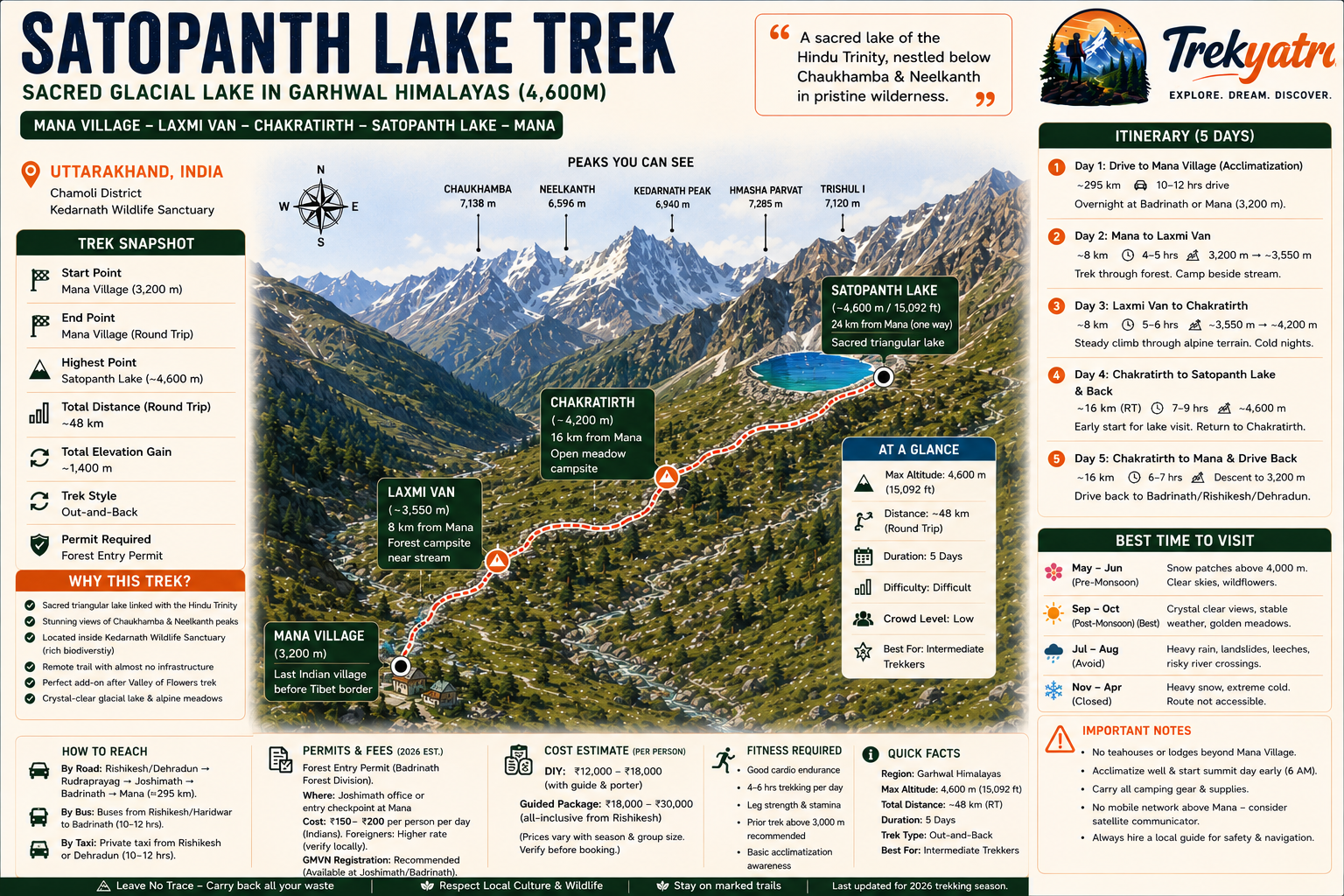
Why Satopanth Lake Trek is on every trekker's list
In an era when Uttarakhand treks increasingly attract large crowds, Satopanth remains refreshingly remote. While the Valley of Flowers — just a ridge away — draws tens of thousands of visitors annually, Satopanth sees a fraction of that footfall, rewarding those who make the effort with a genuine sense of wilderness.
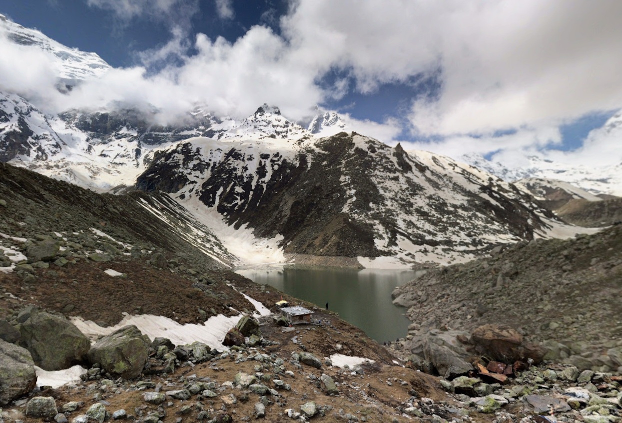
The sacred geometry of the lake itself is remarkable. According to Hindu tradition, each corner of the triangular lake is a bathing ghat for one member of the Trinity: Brahma at one vertex, Vishnu at another, and Shiva at the third. Pilgrims who complete the circumambulation and bathe here are said to attain moksha (liberation). This blend of spiritual purpose and natural grandeur gives the trek a dimension that purely adventure-focused routes lack.
Views of Chaukhamba Peak (7,138 m) and Neelkanth Peak (6,596 m) are visible throughout the upper sections of the trail, and on clear post-monsoon mornings the reflections of these giants in the lake's surface are among the most memorable sights in the Indian Himalaya.
The journey begins at Mana Village, itself a destination worth a day's exploration. Mana is the last Indian village before the Tibet border, home to a small population of Bhotiya people, an ancient cave attributed to the sage Vyas (where the Mahabharata is said to have been dictated), and the roaring Vasudhara Falls a short walk beyond. Starting your trek from this threshold place adds layers of cultural and historical resonance that few other Himalayan walks can match.
What Makes Satopanth Lake Unique?
Beyond its triangular sacred geometry, several features set Satopanth apart from other Himalayan lakes:
- Crystal-clear glacial water: The lake's colour shifts from turquoise in morning light to deep blue at midday. The water is remarkably transparent, fed by snowmelt and glacier runoff from the Satopanth Glacier above.
- Pandava mythology: Local legend holds that the Pandava brothers, during their final Himalayan journey (the Mahaprasthan), rested at Satopanth Lake before ascending to heaven. This connection to the Mahabharata epic amplifies the lake's spiritual weight.
- Alaknanda confluence below: The Alaknanda River, one of the two main headstreams of the Ganges, originates from the Satopanth and Bhagirath Kharak glaciers. Crossing and following this river's youthful, turbulent course on the lower trail is a reminder of how rivers that sustain hundreds of millions of people are born in lonely high-altitude cirques.
At a glance
Ask TrekSage about Satopanth Lake Trek
Get instant answers grounded in verified trek data — beginner-friendliness, best months, permits, packing, and more.
The route at a glance
The standard route runs from Mana Village (3,200 m) to Satopanth Lake (4,600 m) — a one-way distance of approximately 24 kilometres (48 km round trip). The trail climbs roughly 1,400 metres in elevation over three stages, passing through alpine meadows, dense birch and rhododendron forest, moraine fields, and glaciated terrain in the upper reaches.
Key waypoints:
- Mana Village (3,200 m) → Laxmi Van (~3,550 m) → Chakratirth (~4,200 m) → Satopanth Lake (~4,600 m)
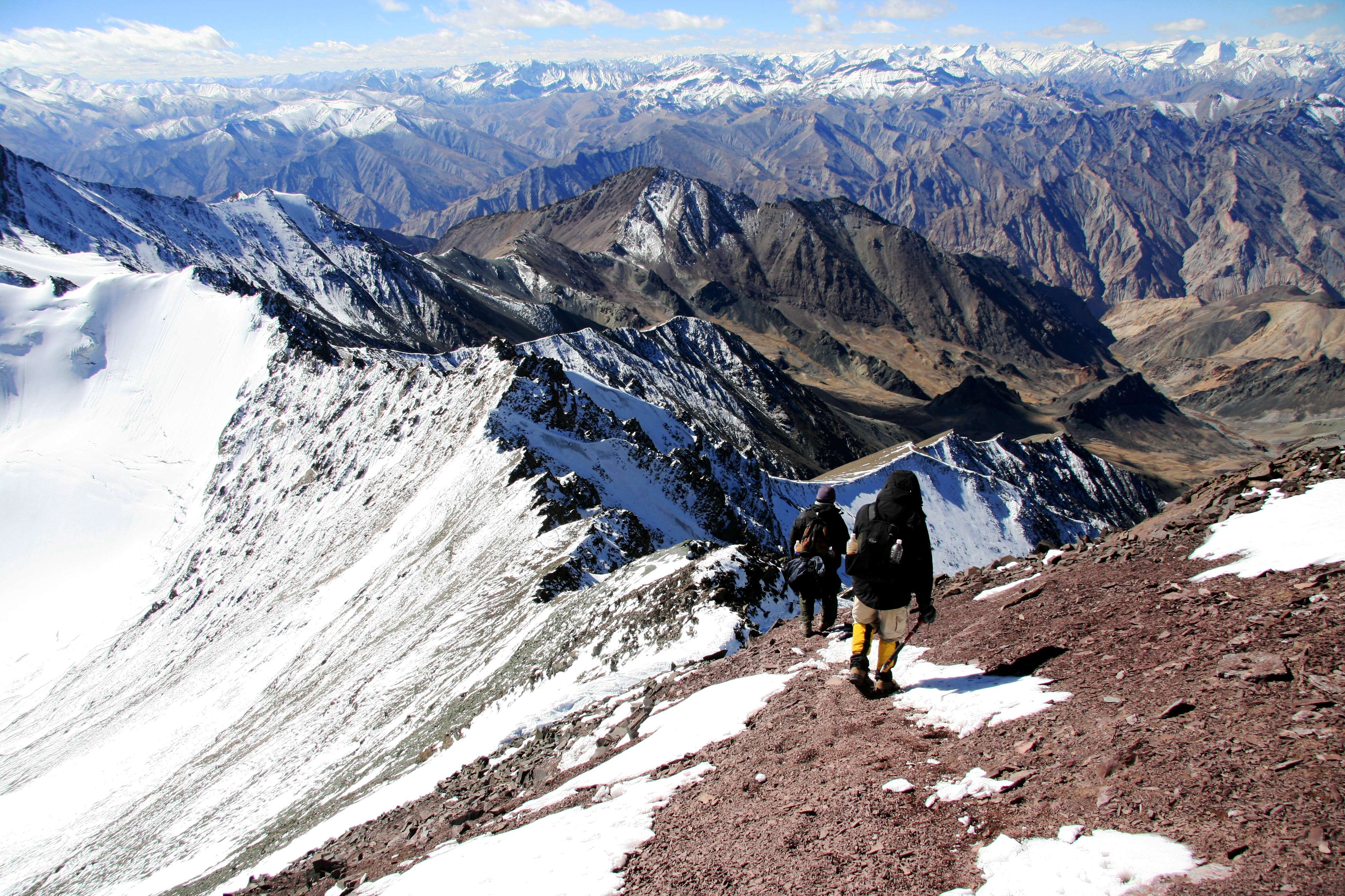
The trail crosses the Alaknanda River on the lower section and involves several boulder-hop or log-bridge crossings of side streams, which become significantly more hazardous during the monsoon. Above Chakratirth, the path traverses open moraine — loose rocks, unstable ground, and potential for sudden weather changes demand full attention.
There are no permanent teahouses, lodges, or medical facilities anywhere beyond Mana Village. This is a fully self-supported wilderness trek.
Elevation Profile & Distance Breakdown
| Segment | Start Point | End Point | Distance | Start Altitude | End Altitude | Elevation Gain |
|---|---|---|---|---|---|---|
| Segment 1 | Mana Village | Laxmi Van | ~8 km | 3,200 m | ~3,550 m | ~350 m |
| Segment 2 | Laxmi Van | Chakratirth | ~8 km | ~3,550 m | ~4,200 m | ~650 m |
| Segment 3 | Chakratirth | Satopanth Lake | ~8 km | ~4,200 m | ~4,600 m | ~400 m |
| Total (one way) | Mana Village | Satopanth Lake | ~24 km | 3,200 m | 4,600 m | ~1,400 m |
Note: Distance figures are approximate. Actual GPS distances may vary slightly depending on trail conditions and route variations. Verify with local guides before departure.
What each day actually looks like
The following 5-day itinerary is the standard plan for the 2026 trekking season. This schedule builds in an acclimatisation buffer at Badrinath/Mana, which is essential at this altitude.
Day 1 — Drive: Haridwar/Rishikesh to Badrinath/Mana
- Mode: Road (bus, shared jeep, or private taxi)
- Distance: ~295 km (Haridwar to Badrinath)
- Duration: 10–12 hours depending on road conditions and stops
- Overnight: Badrinath (3,133 m) or Mana Village (3,200 m) — guesthouses available at Badrinath; basic homestays at Mana
- Notes: The road passes through Joshimath (1,890 m), where the Badrinath Forest Division permit office is located — collect your forest entry permit here if you have not already arranged it at Mana's entry checkpoint. Use the afternoon to visit Badrinath Dham temple and acclimatise. Do not rush. Drink plenty of water and avoid alcohol.
See our Badrinath Dham travel guide and Joshimath travel guide for accommodation and local information.
Day 2 — Mana Village to Laxmi Van
- Distance: ~8 km
- Altitude gain: ~350 m (3,200 m → ~3,550 m)
- Walking time: 4–5 hours
- Overnight: Laxmi Van campsite (~3,550 m)
- Notes: Begin the day with a visit to Mana Village's key landmarks (Vyas Cave, Ganesh Cave, Bhim Pul bridge) before hitting the trail. The path initially follows the eastern bank of the Alaknanda through birch and rhododendron forest. The Laxmi Van camp is a forest clearing with a water source nearby; set up tents early as afternoon temperatures drop quickly.
Day 3 — Laxmi Van to Chakratirth
- Distance: ~8 km
- Altitude gain: ~650 m (~3,550 m → ~4,200 m)
- Walking time: 5–6 hours
- Overnight: Chakratirth campsite (~4,200 m)
- Notes: This is the most demanding day in terms of sustained elevation gain. The trail climbs through transitional terrain — scrubby vegetation gives way to open moraines and boulders. Watch your footing on loose rock. Chakratirth is an open meadow campsite; nights here are cold (temperatures can fall to -5°C or lower even in September). Eat a warm meal, hydrate well, and retire early.
Day 4 — Chakratirth to Satopanth Lake and Return to Chakratirth
- Distance: ~16 km (8 km each way)
- Altitude gain: ~400 m (up), ~400 m (down)
- Walking time: 7–9 hours total
- Overnight: Chakratirth campsite (~4,200 m)
- Notes: This is the summit day. Start by 5:30–6:00 AM. The upper trail crosses moraine and may involve snow patches in May–June; crampons recommended for early-season trips. At the lake, spend 30–45 minutes for exploration, photography, and — if it is part of your purpose — prayer. Do not linger if weather deteriorates. Return to Chakratirth well before dark.
Day 5 — Chakratirth to Mana Village and Drive Back
- Distance: ~16 km trekking (Chakratirth to Mana)
- Walking time: 6–7 hours
- Overnight: Badrinath / onward to Joshimath or Rishikesh
- Notes: The descent is faster but hard on knees — use trekking poles. Reach Mana by early afternoon, allowing time to catch a shared vehicle or pre-arranged taxi back toward Joshimath or Haridwar. If you plan to drive all the way to Rishikesh on Day 5, factor in 10–12 hours of road travel.
Campsite Details Along the Route
Laxmi Van (~3,550 m):
A sheltered forest clearing, Laxmi Van offers the most comfortable camping on the route. Birch trees provide some wind protection, and a freshwater stream runs nearby — purify all water before drinking. This is the last point with significant tree cover; above here the landscape opens dramatically.
Chakratirth (~4,200 m):
An exposed open meadow above the treeline, Chakratirth has historical and religious significance as a meditation site. There is no shelter other than what you carry. Night temperatures can plunge to -5°C to -10°C even in September–October; a quality -10°C sleeping bag is non-negotiable. Wind can be strong. The site offers stunning pre-dawn views of the Chaukhamba massif.
Critical note: There is no permanent infrastructure (teahouses, huts, or lodges) anywhere on this trail beyond Mana Village. Carry all camping equipment, food, and fuel.
When to go
The Satopanth Lake trek is accessible for a relatively short window each year. The 2026 trekking season follows the same seasonal pattern as previous years, though always verify road opening dates closer to departure.
May–June (Pre-Monsoon)
- Conditions: Snow patches on trail above Chakratirth; trail generally passable from mid-May once Badrinath road opens (typically late April/early May)
- Temperature (day/night at lake altitude): 5°C to 12°C / -5°C to -10°C
- Visibility: Generally good, with crisp clear mornings
- Pros: Fewer trekkers, dramatic snow-covered landscapes, wildflowers beginning to bloom in lower sections
- Cons: Crampons or microspikes required above 4,000 m; some stream crossings swollen with snowmelt; requires careful trail judgement
July–August (Monsoon) — Avoid
- Conditions: Heavy rainfall, landslides on the Badrinath road, swollen river crossings, trail erosion, leeches in lower forest sections
- Temperature: Warmer but consistently wet
- Strong recommendation: Do not attempt this trek during July–August. The risk from landslides, flash floods, and unstable moraine is severe. The Badrinath road is frequently closed during this period.
September–October (Post-Monsoon) — Recommended
- Conditions: Skies are clearest after monsoon washes the haze away; trails are stable; wildflowers (lower sections) and golden foliage add colour
- Temperature (day/night at lake altitude): 8°C to 15°C (September) / 0°C to 8°C (October day); -8°C to -15°C nights in October
- Visibility: Excellent — this is when Chaukhamba and Neelkanth reflections in the lake are most photogenic
- Closing: The trek typically becomes inaccessible after late October/early November due to heavy snowfall. Badrinath Dham temple closes in October/November for winter. Plan to complete the trek before the third week of October.
Bottom line for 2026: Target the September 10 – October 15 window for the best combination of clear weather, stable trails, and manageable temperatures.
Is this trek right for you?
Difficulty Rating: Difficult
This is not a trek for casual walkers or first-time Himalayan visitors. The combination of factors that make it difficult:
- High altitude: Reaching 4,600 m, above the threshold where AMS (Acute Mountain Sickness) becomes a serious risk for many people
- Long daily stages: Three consecutive days of ~8 km on rough, rocky, moraine terrain; the return day (Day 4) totals ~16 km
- No infrastructure: No escape to a teahouse if you are exhausted or unwell
- Remote location: Emergency evacuation from upper camps takes many hours
- Terrain: Loose moraine, boulder fields, and (in early season) snow and ice
Fitness requirements:
- Prior experience on at least two treks above 4,000 m is strongly recommended
- 4–6 weeks of dedicated pre-trek training: daily cardio (running, cycling, stair climbing), leg-strengthening exercises (squats, lunges, step-ups), and loaded weekend hikes (5–10 kg pack, 15+ km)
- Good cardiovascular health; not suitable for those with cardiac conditions, respiratory conditions, or severe anaemia
- Age alone is not a disqualifier — fit trekkers in their 50s and 60s complete this route — but honest self-assessment is essential
For general high-altitude fitness and acclimatisation guidance, see our high-altitude trekking tips for India.
What permits you need
Satopanth Lake trek covers approximately 48 km round trip from Mana Village (3,200 m) to a sacred glacial lake at 4,600 m in Uttarakhand's Chamoli district, rated Difficult, best visited September–October.
Nestled at approximately 4,600 metres (15,092 feet) above sea level in the Chamoli district of Uttarakhand, Satopanth Lake is one of the Garhwal Himalaya's most revered and least-crowded high-altitude glacial lakes. Fed by the Satopanth Glacier and ringed by the towering profiles of Chaukhamba and Neelkanth peaks, the lake's strikingly clear blue-green waters sit in a natural amphitheatre of rock, ice, and sky.
For Hindu pilgrims, Satopanth is far more than a scenic destination — it is a site of profound spiritual significance, said to form a perfect equilateral triangle whose three corners are associated with the Hindu Trinity: Brahma, Vishnu, and Shiva. The trek begins from Mana Village (3,200 m), the last inhabited village before the Tibet border on the Badrinath–Mana axis, lending the journey an atmosphere of both adventure and antiquity.
This guide provides everything you need to plan the Satopanth Lake trek in the 2026 trekking season: the complete route, day-wise itinerary, permit details, costs, packing list, safety advice, and honest answers to the questions trekkers ask most. Read every section before you book — this trek demands respect and preparation.
Permits for the Satopanth Lake trek are mandatory and must be arranged before or at the start of the trek.
Forest Entry Permit
- Issuing authority: Badrinath Forest Division (part of the Uttarakhand Forest Department)
- Where to obtain: At the Forest Division office in Joshimath, or at the designated entry checkpoint at Mana Village
- Cost (2026 — verify before travel): Approximately ₹150–₹200 per person per day for Indian nationals; higher rates apply for foreign nationals (exact foreign national fee — confirm with Badrinath Forest Division before travel)
- Duration: Permits cover the number of days you declare for the trek
- Documents required: Government-issued photo ID (Aadhaar card, passport, voter ID)
- Inner-Line Permit: Not required. Satopanth Lake is not in a restricted border zone for the purposes of civilian trekking permits (Mana Village is accessible without an ILP)
GMVN Registration
- Garhwal Mandal Vikas Nigam (GMVN) registration is recommended — it ensures your trek is logged with the local tourism authority, which aids in emergency response
- Registration can be completed at GMVN offices in Badrinath or Joshimath
- This is advisory rather than legally mandatory, but strongly recommended for safety
Important: Permit fees and regulations can change between seasons. Always verify current fees and procedures with the Badrinath Forest Division or GMVN before your 2026 trip. Do not rely solely on any third-party source, including this guide.
For a full overview of Garhwal Himalaya trekking permit requirements, see our Garhwal Himalaya trek permits guide.
What this trek will cost you
DIY Trek (Self-Organised)
| Item | Estimated Cost (2026) |
|---|---|
| Transport: Haridwar/Rishikesh to Badrinath (one way, bus/shared jeep) | ₹800–₹1,500 per person |
| Return transport | ₹800–₹1,500 per person |
| Forest entry permit (5 trek days × ₹150–₹200) | ₹750–₹1,000 per person |
| Local guide (mandatory recommendation) | ₹1,000–₹1,500 per day |
| Porter (optional but advised) | ₹800–₹1,200 per day |
| Camping gear rental (tent, sleeping bag, mat) | ₹500–₹800 per day |
| Food (self-prepared / provisions from Badrinath market) | ₹400–₹600 per day |
| Accommodation (Day 1 in Badrinath) | ₹500–₹1,200 |
| Miscellaneous (fuel, purification tablets, first aid top-up) | ₹500–₹800 |
Approximate DIY total for 5 days (1 trekker, with guide and porter): ₹12,000–₹18,000
Note: If sharing guide/porter costs across a group of 4, costs reduce significantly — approximately ₹8,000–₹12,000 per person.
Organised Package Tours
- Cost range: ₹18,000–₹30,000 per person (all-inclusive from Haridwar/Rishikesh)
- Typically includes: Transport, permits, guide, porters, camping equipment, all meals, first-aid support
- Typically excludes: Personal trekking gear, travel insurance, personal snacks
- Value comparison: Organised packages offer significant advantages on a remote trek like Satopanth — experienced guides, pre-arranged permits, quality camping gear, and emergency protocols. For first-time visitors to this region, the premium over DIY is well justified. DIY suits experienced trekkers with their own gear who are comfortable navigating permit bureaucracy independently.
All cost estimates are indicative for 2026 and subject to change. Verify with operators and permit offices before booking.
What to pack
Gear & Equipment
- 4-season tent (capable of handling wind and sub-zero temperatures)
- Sleeping bag rated to -10°C or below
- Sleeping mat (inflatable or foam)
- Trekking poles (pair — essential on moraine descent)
- Crampons or microspikes (essential May–June; carry October just in case)
- Headlamp with spare batteries
- Comprehensive first-aid kit (including AMS medication — consult your doctor about Diamox/acetazolamide prescription)
- Water purification tablets or filter
- Trekking backpack (50–65 L for overnight stages)
- Daypack (25–30 L for Day 4 summit push from Chakratirth)
- Camp stove and fuel (no firewood available above Laxmi Van)
- Cooking utensils and food containers
Clothing Layers
- Moisture-wicking thermal base layers (top and bottom)
- Mid-layer fleece or down jacket
- Waterproof/windproof outer shell jacket and trousers
- Insulated down jacket (for camp evenings)
- Trekking trousers (2 pairs)
- Warm gloves and waterproof over-mittens
- Balaclava or warm hat
- Sun hat or cap
- Gaiters (for moraine and early-season snow)
- Trekking boots (waterproof, ankle support, broken in before trek)
- Camp sandals or lightweight shoes
- Merino wool or synthetic trekking socks (4–5 pairs)
- Sunglasses (UV protection — UV intensity is severe at 4,000+ m)
Documents
- Original government-issued photo ID (Aadhaar, passport, voter ID)
- Photocopies of ID (keep separate from originals)
- Forest entry permit (carry multiple copies)
- GMVN registration confirmation
- Emergency contact list (printed, not just on phone)
- Travel insurance documents (ensure policy covers high-altitude trekking and emergency evacuation)
Food & Nutrition
- High-calorie trail snacks: nuts, dried fruit, energy bars, chocolate
- ORS (Oral Rehydration Salts) sachets
- Instant meals / dehydrated food for camp dinners
- Tea/coffee sachets, instant soups
- Electrolyte tablets
- Minimum 3-litre water-carrying capacity
Staying safe on the mountain
Acute Mountain Sickness (AMS)
AMS is a genuine risk at Satopanth Lake's altitude of 4,600 m. Symptoms include headache, nausea, dizziness, fatigue, and loss of appetite. If symptoms worsen or you experience confusion, inability to walk straight, or fluid in lungs/brain (HACE/HAPE) — descend immediately without delay. No mountain view is worth your life.
- Acclimatise: Spend at least one full day in Badrinath (3,133 m) or Mana Village (3,200 m) before starting the trek — this is non-negotiable
- Ascend slowly: Follow the itinerary as written; do not try to compress Days 2–3 into a single day
- Hydrate: Drink 3–4 litres of water daily
- Consult a doctor about Diamox (acetazolamide) before travel — not suitable for everyone
River Crossings
- The Alaknanda and its tributaries run fast and cold. In May–June, snowmelt swells crossings by midday — make all crossings in the early morning
- During monsoon (July–August), crossings can be dangerously high — another reason to avoid this season entirely
No Solo Trekking
- Solo trekking on Satopanth is strongly discouraged. There are no permanent residents or facilities beyond Mana. In an emergency, you need a companion or guide who can seek help
- Hire a local guide: Beyond safety, local guides understand trail conditions, weather patterns, and can communicate with rescue services
Mobile Connectivity
- Mobile phone signals (all networks) effectively end at Mana Village. Do not rely on your phone for navigation or emergency communication beyond this point
- Carry a satellite communicator (e.g., Garmin inReach or equivalent) if possible — this could save your life in a genuine emergency
Emergency Contacts
- Joshimath SDRF (State Disaster Response Force): +91-1389-222180 (verify this number is current before your 2026 trek)
- Badrinath Base Camp / Local Police Post: Enquire locally at Joshimath or Badrinath for the current-season contact numbers
- Leave a copy of your itinerary and emergency contacts with someone at home and with your guesthouse in Badrinath
Weather
- Himalayan weather at this altitude changes rapidly. Clear morning skies can turn to afternoon thunderstorms with little warning
- Start each day's walking by 6:00–7:00 AM to maximise safe hours and reach camp before afternoon weather deteriorates
- If weather looks threatening at Chakratirth on Day 4 morning, be prepared to delay the summit push by one day rather than take risks
For more guidance, see our high-altitude trekking tips for India.
Similar treks to explore
Nubra Valley Trek: Routes, Permits & Best Time (2026)
The Nubra Valley trek is a 65–90 km high-altitude route in Ladakh crossing Khardung La (5,359 m) into a cold-desert valley at 3,048 m, completed in 7 days.
Sham Valley Trek: Complete Beginner's Guide (2026)
The Sham Valley Trek is Ladakh's most beginner-friendly high-altitude trek, reaching a maximum of ~3,700m over 4–5 days.
Stok Kangri Trek: Complete Guide for Climbers
The Stok Kangri trek is a high-altitude mountaineering route in Ladakh, India, reaching a summit of 6,153 metres — one of India's most accessible 6,000m+ peaks.
Common questions answered
Satopanth Lake sits at approximately 4,600 metres (15,092 feet) above sea level in the Chamoli district of Uttarakhand. It lies in the upper Alaknanda basin, below the Satopanth Glacier.
Live Conditions
Real-time weather & trail status
Trail Conditions
Crowdsourced reports from trekkers who've done this route
Sign in to add a trip report
Find a Trek Buddy
Connect with trekkers planning the same route
No buddies yet for this trek
Sign in and be the first to post a planning signal.