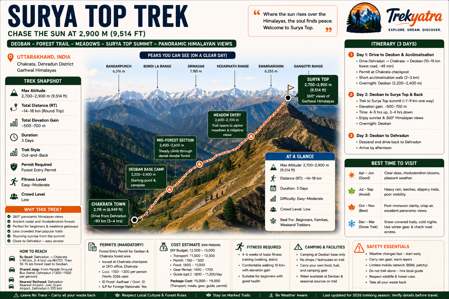
Why Surya Top Trek is on every trekker's list
Surya Top Trek is an easy-to-moderate trail in Chakrata, Uttarakhand, reaching ~2,700–2,900 m with panoramic Himalayan views, best done October–November or April–May.
Tucked inside the Chakrata forests of the Garhwal Himalayas, the Surya Top Trek is one of Uttarakhand's most rewarding yet underrated getaways. At a summit altitude of approximately 2,700–2,900 metres, this trail threads through ancient cedar and rhododendron forests before opening onto a panoramic ridgeline that — as the name suggests — feels tailor-made for watching the sun claim the sky. Unlike the well-worn trails of Kedarkantha or Nag Tibba, Surya Top sees a fraction of the footfall, making it a rare offbeat experience within easy reach of Dehradun. This guide covers everything you need for the 2026 trekking season: route details, permits, costs, itinerary options, packing lists, and safety advice.
In a state overflowing with incredible trails, Surya Top earns its place at the top of any offbeat shortlist. Here is why trekkers keep coming back:
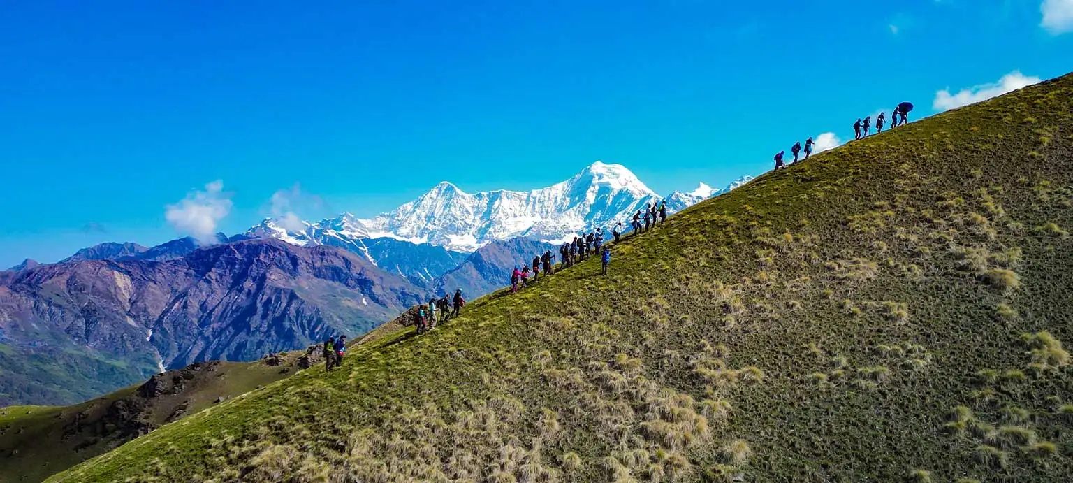
The views are genuinely jaw-dropping. On clear days — particularly in October and April — the summit ridge delivers an unobstructed 360-degree panorama of the western Garhwal Himalayas, with peaks stretching from the Tons River Valley in the north to the distant outline of Bandarpunch and the Kedarnath range. Very few treks at this altitude offer that kind of visual payoff.
It is blissfully uncrowded. Where Kedarkantha draws thousands of trekkers each winter weekend, Surya Top is still the preserve of those who do their homework. You can camp under a genuinely dark, star-filled sky — a luxury that is increasingly rare on Uttarakhand's popular routes.
The access is easy. Sitting roughly 90 km from Dehradun via the NH707 and located in the Chakrata-Deoban forest belt near Mussoorie, the trek is reachable in a single morning drive. That accessibility makes it perfect for a long weekend without the need for extensive travel logistics.
Beginners are welcome. The trail demands solid walking fitness but no technical climbing skills. Families, college groups, and first-time trekkers regularly complete it comfortably. For more beginner-friendly options near Dehradun, see our best treks near Dehradun guide.
How Does Surya Top Compare to Other Uttarakhand Treks?
Compare Surya Top with the two most popular beginner treks in Uttarakhand and the differences become clear:
- Kedarkantha (see our Kedarkantha trek guide) tops out near 3,800 m with a significant high-altitude snow section in winter, attracts large organised groups, and requires early booking with multiple operators.
- Nag Tibba (see our Nag Tibba trek guide) is excellent but has become one of the most-walked weekend trails from Dehradun — trail erosion and crowding are real concerns on peak weekends.
- Surya Top sits lower, stays quieter, and rewards you with the kind of raw, unhurried forest experience that made Uttarakhand trekking special in the first place. The name itself — Surya meaning sun — comes from the spectacular sunrise views that explode over the Himalayan horizon from the open meadows at the top, a moment that feels earned precisely because fewer people have seen it.
For more offbeat ideas in the state, browse our offbeat treks in Uttarakhand collection.
At a glance
Ask TrekSage about Surya Top Trek
Get instant answers grounded in verified trek data — beginner-friendliness, best months, permits, packing, and more.
The route at a glance
The trek originates from either Chakrata town (approximately 2,118 m / 6,949 ft) or the Deoban forest rest house (approximately 2,200–2,400 m), which serves as the more common base point for the summit push. Both entry points sit within the Chakrata cantonment and civil forest area managed by the Uttarakhand Forest Department.
Total trail distance: Approximately 14–18 km for the full out-and-back route, depending on the variant taken from Chakrata or Deoban.
Elevation range: Base camp at Deoban approximately 2,200–2,400 m rising to the Surya Top summit at approximately 2,700–2,900 m.
Terrain type: The majority of the trail passes through dense deodar (Himalayan cedar), oak, and rhododendron forest. The forest floor is soft and well-shaded, making mid-day walking pleasant even in summer. Approaching the summit, the tree cover thins and the trail opens onto broad grassy meadows and a rocky ridgeline. There are no technical sections, fixed ropes, or scrambling.
Water sources: Seasonal springs exist along the lower forest sections, but water availability cannot be guaranteed, particularly in the pre-monsoon period (April–May). Carry at least 2 litres from base and use a filter or purification tablets at any natural source.
Forest zones: The Deoban forest area is a protected reserve. Stay on the marked trail, avoid disturbing vegetation, and adhere to the forest department's no-fire policy outside designated campsites.
For a broader look at the Chakrata region, see our Chakrata travel guide.
Elevation Profile and Trail Terrain
| Section | Approx. Altitude | Character |
|---|---|---|
| Deoban Base / Trailhead | ~2,200–2,400 m | Forest road, vehicle access |
| Mid-forest section | ~2,400–2,600 m | Steady ascent, dense cedar forest |
| Forest fringe / meadow entry | ~2,600–2,700 m | Trail widens, views open |
| Surya Top Summit Ridge | ~2,700–2,900 m | Open meadow, rocky outcrops, panoramic views |
The ascent gradient is moderate throughout — there are no sudden steep technical sections. The most demanding stretch is the final 200–300 m of elevation gain through the thinning forest to the meadow, where the trail becomes looser underfoot. Total elevation gain from Deoban base is approximately 500–700 m. [Verify precise elevation gain against GPS-tracked route data.]
The standard approach is from Dehradun, the nearest major city.
By Road (Recommended):
From Dehradun, take NH707 westward toward Vikasnagar and Chakrata. The distance is approximately 90 km and takes 3–4 hours depending on road conditions, season, and traffic through hill sections. The road quality is reasonable up to Chakrata but becomes narrower and rougher on the Deoban forest road. High-clearance vehicles handle it better; SUVs and jeeps are preferable to small sedans.
From Deoban: Chakrata to Deoban is a further 10–15 km on a forest road (approximately 45 minutes). [Road condition to Deoban in winter and post-monsoon season should be confirmed locally before travel.]
Shared Jeeps from Dehradun:
Shared jeeps depart from Parade Ground Bus Stand, Dehradun toward Chakrata. Frequency is reasonable in morning hours. Cost: approximately INR 300–500 per person one way. [2026 shared jeep fares subject to change; confirm at Parade Ground before travel.]
Private Taxi:
A private cab from Dehradun to Deoban costs approximately INR 2,500–3,500 one way for the vehicle (split among passengers). Book through Dehradun's prepaid taxi counters or local cab aggregators.
Nearest Railhead: Dehradun Railway Station (well-connected to Delhi and major North Indian cities).
Nearest Airport: Jolly Grant Airport, Dehradun — served by daily flights from Delhi, Mumbai, and select other cities. From the airport, Chakrata is approximately 100+ km by road.
What each day actually looks like
The standard plan is a 2-night, 3-day itinerary combining a road journey, acclimatisation, the summit, and return. All timings are approximate and weather-dependent.
Day 1 — Dehradun to Deoban (Drive + Short Walk)
- Depart Dehradun early morning (6:00–7:00 am)
- Drive via NH707 to Chakrata (~90 km, approximately 3–4 hours depending on road conditions and season)
- Collect forest entry permits at the Chakrata checkpost
- Continue to Deoban (~10–15 km further, ~45 min on forest road) and set up camp at the forest rest house area
- Afternoon: short acclimatisation walk of 2–3 km through the surrounding forest, elevation ~2,200–2,400 m
- Return to camp for dinner; sleep early
- Elevation gain this day: Minimal (drive-based)
Day 2 — Deoban to Surya Top Summit and Return to Camp
- Early start (6:00 am) to catch sunrise from the trail or summit
- Trek from Deoban base to Surya Top summit: approximately 7–9 km one way, 4–5 hours ascent
- Spend 1–2 hours at the summit: take in the Himalayan panorama, photograph the Tons Valley and distant peaks
- Descend back to Deoban camp: approximately 3–4 hours
- Elevation gain: ~500–700 m
- Total walking time: 7–9 hours including breaks
Day 3 — Deoban to Dehradun (Return Drive)
- Morning optional short walk; break camp
- Drive from Deoban back to Chakrata and onward to Dehradun
- Arrive Dehradun by early afternoon
- Elevation gain this day: None
1-Day Surya Top Trek Option
For trekkers based in Chakrata who want a quick day hike, a single-day summit and return is feasible but demanding. Start no later than 5:30–6:00 am from Deoban to ensure you reach the top in time for morning views and return before dark. A reasonable level of trail fitness — comfortable walking 10+ km with elevation — is required. Carry a full day's food and water (minimum 3 litres), a headlamp, a rain jacket, and ensure you have your forest permit in hand before setting off. Do not attempt this option alone without a local guide or prior knowledge of the trail, as signage can be sparse in the forest sections.
When to go
Choosing the right window dramatically affects your experience on this trail.
Summer — April to June (Good)
Temperatures at the summit range from 5–18°C. Skies are generally clear in April and May, delivering excellent visibility for Himalayan views. Rhododendrons bloom in late March–April, adding colour to the forest. June can bring pre-monsoon haze and occasional afternoon thunderstorms; start early and plan to be off the summit by noon.
Monsoon — July to September (Not Recommended)
Heavy rainfall makes the trail slippery and significantly increases leech activity throughout the forest sections. Cloud cover eliminates the panoramic views that make Surya Top worthwhile. Flash flooding is a risk on approach roads near Chakrata. Unless you are specifically seeking a monsoon forest experience, this window is best avoided. [Monsoon trail closure policies should be confirmed with DFO Chakrata for 2026.]
Autumn — October to November (Best Season)
This is the prime window. Post-monsoon skies are crystal clear, humidity is low, temperatures are crisp (summit temperatures 0–12°C), and the forest turns golden. Visibility of distant Himalayan peaks is at its annual peak. October–November is our top recommendation for the Surya Top Trek.
Winter — December to March (Snow Trek Experience)
Surya Top receives snowfall from late December through February, transforming the trail into a classic Himalayan snow trek. The experience is beautiful but demands preparation: layered winter clothing, microspikes or gaiters, and a sleeping bag rated to at least -10°C for camping. The approach road to Deoban can become inaccessible after heavy snowfall; check road conditions before departing Dehradun. March brings warming temperatures and clear post-winter skies, making it a quieter but rewarding shoulder option.
Ideal windows: October–November and April–May.
Is this trek right for you?
Difficulty rating: Easy to Moderate.
The Surya Top Trek is one of the most accessible Himalayan trails in Uttarakhand, making it an ideal first trek for those new to the mountains. There is no technical climbing, no fixed ropes, and no extreme altitude to manage. The trail is a straightforward forest path with a consistent, manageable gradient.
Who can do it:
- First-time trekkers with basic walking fitness
- Teenagers and adults up to their 60s in good health
- School and college groups with adequate supervision
- Families with children aged 10 and above (depending on fitness)
Recommended fitness preparation:
- Walk 5 km daily for at least 2 weeks before the trek
- Include stair climbing or incline walking to prepare leg muscles for sustained ascent
- Stay well hydrated in the days leading up to the trek
Altitude note: At 2,700–2,900 m, Surya Top is well below the threshold where acute mountain sickness (AMS) becomes a serious concern for most healthy individuals. However, those with pre-existing cardiovascular or respiratory conditions should consult a doctor before trekking. Ascend slowly, drink water regularly, and descend if you experience persistent headache, dizziness, or nausea.
For a detailed overview of trek permits across Uttarakhand, see our Uttarakhand trek permits guide.
What permits you need
A forest entry permit is required for the Deoban and Chakrata forest area.
The Chakrata-Deoban belt falls within a protected forest zone managed by the Uttarakhand Forest Department (Divisional Forest Officer, Chakrata). All trekkers must obtain a permit before entering the forest.
Where to get it:
- At the forest checkpost at or near Chakrata on the approach road to Deoban
- Alternatively, in advance from the Divisional Forest Officer (DFO) office, Chakrata
- [As of 2026, online permit availability via the Uttarakhand Forest Department portal should be confirmed — offline collection at the checkpost has historically been the standard process.]
Documents required:
- Valid government-issued photo ID (Aadhaar card, passport, driving licence)
- One photocopy of ID per person is advisable
Permit cost:
- Approximately INR 150–300 per person for Indian nationals [2026 fee structure must be verified directly with DFO Chakrata — rates are subject to annual revision by the Uttarakhand Forest Department.]
Foreigners — Inner Line Permit:
Chakrata is a restricted/cantonment area and foreign nationals require an Inner Line Permit (ILP) in addition to the standard forest entry permit. The ILP can be obtained from the District Magistrate's office in Dehradun or relevant SDM offices. Processing time varies; apply at least 2–3 days in advance. [ILP requirements and processing times for foreign nationals in Chakrata should be confirmed with the DM office Dehradun for 2026.]
What this trek will cost you
DIY Cost Breakdown (Per Person, 3 Days)
| Item | Estimated Cost (INR) |
|---|---|
| Shared jeep Dehradun (Parade Ground) to Chakrata | 300–500 |
| Private cab Dehradun to Chakrata/Deoban (split 4 ways) | 600–900 per person |
| Forest entry permit | 150–300 |
| Camping gear rental (tent, sleeping bag, mat) | 400–700 |
| Food and provisions (3 days) | 600–1,000 |
| Local guide (optional, recommended) | 800–1,200 per day |
| Miscellaneous (water, snacks, tips) | 200–400 |
| Total DIY estimate | ~INR 2,500–5,000 per person |
[Transport costs and gear rental rates reflect best available estimates for 2026 but should be verified with local operators and jeep services from Dehradun's Parade Ground bus stand.]
Guided Package Cost
Organised packages from Dehradun-based trek operators typically include transport, camping gear, meals, permits, and a guide. Expect to pay INR 5,000–9,000 per person for a 3-day guided package. [Package rates vary significantly by operator; verify current 2026 pricing before booking.]
DIY vs. Package — Quick Comparison:
- DIY gives flexibility, lower cost, and a more independent experience — but requires more logistical planning, your own gear or rentals, and confidence on a trail that is not always well-signed.
- Guided package is better for first-timers, those unfamiliar with the region, or anyone trekking solo — the local knowledge and safety net justify the extra cost.
What to pack
For a comprehensive general trekking packing guide, see our India trekking packing list. Below is what Surya Top specifically demands.
Clothing (layering system is essential):
- Moisture-wicking base layer (top and bottom)
- Insulating mid-layer: fleece or light down jacket
- Waterproof and windproof outer shell / rain jacket
- Trekking pants (quick-dry; avoid denim)
- Warm hat, gloves, and neck gaiter (essential Oct–Mar)
- Sun hat or cap (Apr–Jun)
- 2–3 pairs of moisture-wicking trekking socks
Footwear:
- Ankle-support waterproof trekking shoes with grip sole (essential — forest terrain can be wet and rooted)
- Lightweight camp sandals or flip-flops for evening
Gear:
- Trekking poles (highly recommended for descent)
- Headlamp with spare batteries
- 40–50 litre backpack with rain cover
- Sleeping bag (see camping section below)
- Trekking poles
Nutrition and Hydration:
- Dry snacks: trail mix, energy bars, nuts, chikki
- ORS sachets (minimum 6)
- 2 x 1-litre water bottles or a 2-litre hydration bladder
- Water purification tablets or a filter straw
Documents:
- Original government photo ID
- Photocopy of ID (keep separate from original)
- Forest permit copy
- Emergency contact list (written, not just on phone)
- ILP copy (foreign nationals)
Miscellaneous:
- High-SPF sunscreen (SPF 50+) and UV-protection sunglasses
- Insect repellent (DEET-based for monsoon/shoulder season)
- Basic first aid kit: bandages, antiseptic cream, blister plasters, ibuprofen, antihistamines
- Biodegradable wet wipes
- Trekking gaiters (useful for snow season Dec–Feb)
Camping Gear Essentials for Surya Top
If you are camping independently rather than with an organised operator:
- Tent: A 3-season mountain tent is adequate for Apr–Nov. Winter camping (Dec–Feb) requires a 4-season tent or a very sturdy 3-season model with snow stakes.
- Sleeping bag: Rated to -5°C minimum for autumn and spring camping; rated to -10°C to -15°C for winter nights at Deoban. Overnight temperatures at Deoban in winter can drop below -10°C; verify with local operators.]
- Sleeping mat: Foam or inflatable insulated mat — crucial for ground insulation in cold seasons
- Camp stove and fuel canister: If self-catering; confirm fuel canister availability in Chakrata before relying on it
- Waterproof stuff sacks / dry bags: To protect sleeping bag and clothing from moisture
Staying safe on the mountain
Altitude and AMS: At 2,700–2,900 m, Surya Top is unlikely to trigger serious altitude sickness in healthy individuals. However, ascend gradually, stay hydrated, and descend if you or any group member develops persistent headache, nausea, or disorientation. Do not ignore symptoms.
Weather changes: Hill weather in Uttarakhand is notoriously fast-moving. Clear skies can turn to rain or hail within 30–45 minutes. Always carry a rain jacket regardless of the morning forecast. Aim to be off the summit and back in the forest treeline by early afternoon.
Trail markings: Surya Top trail is not comprehensively signposted throughout. Solo trekkers or those unfamiliar with the area should carry a downloaded offline map (Maps.me or Google Maps offline) and ideally hire a local guide from Chakrata.
Mobile network: Coverage in the Chakrata-Deoban forest area is limited to partial BSNL signal in some spots. Do not rely on your phone for navigation or emergency calls. Inform someone at your accommodation in Chakrata of your trekking plan and expected return time.
Emergency contacts:
- Chakrata Forest Office (DFO Chakrata): Obtain the current number locally before trekking
- Civil Hospital Chakrata: The nearest medical facility; basic emergency care available [Confirm operating hours and emergency capacity for 2026]
- Uttarakhand Emergency / Disaster Management: 1070
Wildlife: The Deoban forest harbours leopards and other wildlife. Do not trek alone in low-light conditions (dawn/dusk). Make noise while walking through dense forest sections to alert animals of your presence. Do not leave food unattended at camp. If you encounter a leopard: do not run, maintain eye contact, appear large, and back away slowly.
Leave No Trace: Pack out all waste. The forest department strictly prohibits lighting open fires outside designated areas. Use a camp stove for cooking.
Trekking buddy rule: Always trek with at least one other person or a local guide, especially given the limited mobile connectivity and trail-marking quality on this route. Solo trekking without a guide is not recommended for first-time visitors to the area.
Similar treks to explore
Nubra Valley Trek: Routes, Permits & Best Time (2026)
The Nubra Valley trek is a 65–90 km high-altitude route in Ladakh crossing Khardung La (5,359 m) into a cold-desert valley at 3,048 m, completed in 7 days.
Sham Valley Trek: Complete Beginner's Guide (2026)
The Sham Valley Trek is Ladakh's most beginner-friendly high-altitude trek, reaching a maximum of ~3,700m over 4–5 days.
Stok Kangri Trek: Complete Guide for Climbers
The Stok Kangri trek is a high-altitude mountaineering route in Ladakh, India, reaching a summit of 6,153 metres — one of India's most accessible 6,000m+ peaks.
Common questions answered
The Surya Top summit sits at approximately 2,700–2,900 metres (8,858–9,514 feet) above sea level. The base camp at Deoban is around 2,200–2,400 metres, giving a total elevation gain of roughly 500–700 metres on the summit day.
Live Conditions
Real-time weather & trail status
Trail Conditions
Crowdsourced reports from trekkers who've done this route
Sign in to add a trip report
Find a Trek Buddy
Connect with trekkers planning the same route
No buddies yet for this trek
Sign in and be the first to post a planning signal.