Why Valley of Flowers Trek 2026 is on every trekker's list
Few treks in India can claim the combination of ecological rarity, spiritual significance, and sheer visual splendour that the Valley of Flowers delivers.
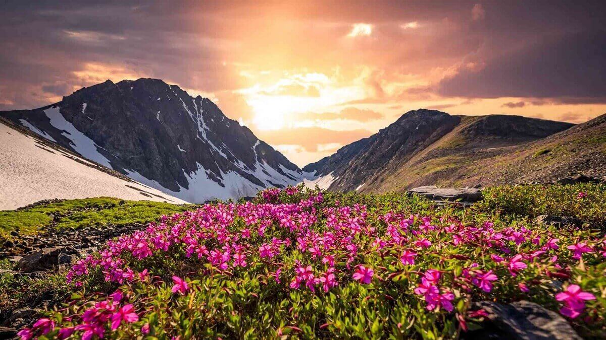
UNESCO Recognition & Biodiversity: As part of the Nanda Devi Biosphere Reserve — a UNESCO World Heritage Site — the valley is home to over 500 flowering plant species, including rare Himalayan endemics. This is not a trek where you pass through scenery; you walk into it.
The Monsoon Magic: Most Himalayan treks advise avoiding the July–September monsoon window. The Valley of Flowers inverts that logic entirely. The heavy rainfall is precisely what triggers the legendary bloom. Walking through acres of Brahmakamal, Blue Poppy, Cobra Lily, and Himalayan Balsam under clearing morning skies is an experience that no post-monsoon trek can replicate.
Hemkund Sahib Proximity: The nearby Hemkund Sahib — one of the world's highest Gurudwaras at 4,329 m — sits just 6 km from the Ghangaria base camp. This makes the trek a rare combination of natural wonder and living Sikh pilgrimage, drawing a diverse mix of visitors and creating a remarkably well-serviced trail infrastructure.
Beginner-Friendly Gradient: Despite its UNESCO prestige, the core trek to the valley is rated easy-to-moderate. The trail is wide, well-marked, and supported by mule services. Families with older children (10+) and adults up to their sixties complete it regularly.
Explore more Uttarakhand treks →
At a glance
Ask TrekSage about Valley of Flowers Trek 2026
Get instant answers grounded in verified trek data — beginner-friendliness, best months, permits, packing, and more.
The route at a glance
The main trekking route follows a logical progression from the roadhead at Govindghat up the Pushpawati River valley to the base village of Ghangaria, and from there into the national park itself.
- Total distance (round trip, valley only): ~38 km
- Maximum elevation (valley floor): 3,658 m
- Maximum elevation (with Hemkund Sahib): 4,329 m
- Trail type: GMVN-managed, well-marked, partially paved
- Technical difficulty: None — no ropes, ladders, or scrambling required
Govindghat to Ghangaria
The journey begins at Govindghat (1,828 m), a small town at the confluence of the Alaknanda and Pushpawati rivers, roughly 20 km from Joshimath on the Badrinath Highway.
The 14 km trail to Ghangaria (3,050 m) follows the Pushpawati River upstream, gaining altitude gradually through dense mixed forest and past several dhaba settlements. Key landmarks include the suspension bridge over the Pushpawati near the trail start, the small village of Pulna (about 4 km in, where the motorable road ends), and increasingly open views of the surrounding ridgeline as you approach Ghangaria.
The ascent takes 5–6 hours at a comfortable pace. Mule hire is available from Govindghat/Pulna for those who prefer not to walk the full distance (approximately INR 1,500–2,500 per day — flag: verify 2026 mule rates locally). A helicopter service operates between Govindghat and Ghangaria during the trekking season, priced at approximately INR 3,500 one-way (flag: verify 2026 helicopter fares with operator before booking).
Ghangaria to Valley of Flowers
Ghangaria (3,050 m) is the sole accommodation hub for this trek — a compact village of guesthouses, dhabas, and the GMVN Tourist Rest House. From here, the 4 km trail to the Valley of Flowers entry gate involves a moderate climb through forest and open scrub before the trail levels into the valley floor.
The forest department entry gate is where you pay your national park permit fee (see Permits section). Camping inside the valley is strictly prohibited. Day visitors must return to Ghangaria before sunset. The valley itself stretches across 87 sq km of alpine meadow, and even a 3–4 hour exploration barely scratches its full expanse — focus on the marked trail corridor and viewpoints.
Optional: Ghangaria to Hemkund Sahib
For those with a spare day and willing legs, Hemkund Sahib is a compelling add-on. The 6 km trail from Ghangaria climbs steeply to 4,329 m, gaining over 1,200 m of elevation on a well-paved but relentlessly ascending path shared with pilgrims.
At the top, the sacred glacial lake of Hemkund and the gleaming white Gurudwara Shri Hemkund Sahib offer a profoundly different atmosphere from the floral valley — austere, high-altitude, and deeply moving. The Langar (free community kitchen) run by the Gurudwara serves hot meals to all visitors regardless of faith. Allow 3–4 hours each way and depart by 5:30–6:00 am to return before afternoon weather deteriorates.
Full Hemkund Sahib trek guide →
What each day actually looks like
This 6-day itinerary begins and ends in Haridwar, the most common gateway city with good rail and road connectivity.
Day 1: Haridwar to Joshimath
- Distance: ~260 km by road
- Drive time: 8–9 hours
- Overnight: Joshimath (1,890 m)
Depart Haridwar early (5–6 am) by private taxi or shared vehicle via Rishikesh, Devprayag, Rudraprayag, and Karnaprayag, ascending steadily through the Alaknanda valley to Joshimath. This night at Joshimath is your critical acclimatization stop — do not skip it. Explore the town, eat a light meal, and rest. Joshimath travel guide →
Day 2: Joshimath to Govindghat to Ghangaria
- Drive: Joshimath to Govindghat — 20 km (~45 minutes)
- Trek: Govindghat (1,828 m) to Ghangaria (3,050 m) — 14 km, 5–6 hours
- Elevation gain: ~1,222 m
- Overnight: Ghangaria
Start the drive to Govindghat by 7 am. Begin the trek from Govindghat (or Pulna, 4 km by vehicle/mule) by 8 am. Pack a lunch from Joshimath — dhabas on the trail exist but are basic. Arrive Ghangaria by early afternoon, check in, hydrate, and rest. Avoid heavy exertion this evening.
Day 3: Valley of Flowers Day Hike
- Trek: Ghangaria to Valley of Flowers — 4 km one-way, ~1.5–2 hours each way
- Explore time: 3–4 hours inside the valley
- Overnight: Ghangaria
Depart Ghangaria no later than 6:00–6:30 am. Morning hours (6 am–noon) offer the clearest skies, the richest light for photography, and minimal rain risk. Afternoon showers — often heavy — are near-certain in July and August. Pay your permit fee at the entry gate and keep your ID handy. Photograph freely but do not pluck or remove any flowers — it is illegal inside the national park and carries a fine. Return to Ghangaria by 1–2 pm, well ahead of rain.
Day 4: Optional Hemkund Sahib Excursion
- Trek: Ghangaria to Hemkund Sahib — 6 km one-way, ~3–4 hours ascent
- Altitude: 4,329 m
- Overnight: Ghangaria
Depart by 5:30 am sharp. The steep climb demands a slow, steady pace — this is not the day to race. Visit the Gurudwara, take Langar prasad, spend time at the glacial lake, and begin descent by noon. Return to Ghangaria by 3–4 pm. Altitude sickness risk increases significantly here — if you have a headache, nausea, or dizziness at the top, descend immediately and do not overnight above Ghangaria. Those skipping Hemkund Sahib can use Day 4 for a second valley visit or a full rest day.
Altitude sickness prevention guide →
Day 5–6: Return Journey
- Day 5: Trek Ghangaria to Govindghat (14 km, 4–5 hrs descent), drive to Joshimath — overnight Joshimath
- Day 6: Drive Joshimath to Haridwar via Rishikesh (~260 km, 8–9 hrs)
The descent to Govindghat is significantly faster than the ascent but hard on the knees — trekking poles are strongly recommended. From Govindghat, shared taxis or pre-booked vehicles return to Joshimath. Depart Joshimath by 6 am on Day 6 for a comfortable Haridwar arrival by late afternoon. Haridwar travel guide →
When to go
The trail officially opens June 1 and closes October 31 each year. The best time for peak bloom is mid-July to mid-September.
| Month | Conditions | Flora | Recommendation |
|---|---|---|---|
| June | Snow patches early in month, clearing by mid-June | Early bloomers only | Possible but limited flowers |
| July | Peak monsoon, lush, heavy rain | Peak bloom begins | ✅ Best for flowers |
| August | Heavy monsoon continues | Peak bloom — maximum species | ✅ Best overall |
| September (early) | Rains easing, clearer mornings | Late bloom, thinning | ✅ Good balance of flowers and visibility |
| September (late) | Mostly dry | Flora fading | Acceptable, fewer flowers |
| October | Dry, cool, pre-closure | Minimal bloom | Trail closes Oct 31 |
Rainfall advisory: July and August see near-daily afternoon showers, often heavy. Start your valley hike by 6 am without exception. Landslides can temporarily block the Badrinath Highway (Rishikesh–Joshimath road) — build a 1-day buffer into your travel plan. Monsoon trekking tips →
Snow note (early June): Snow patches may persist on the Ghangaria–Valley trail until mid-June in years of heavy winter snowfall. Check GMVN advisories before departing if trekking before June 15.
The Valley of Flowers sits in a monsoon-dominated weather zone from July through mid-September.
| Location | Temperature Range (July–August) | Temperature Range (September) |
|---|---|---|
| Ghangaria (3,050 m) | 8–18°C | 6–16°C |
| Valley floor (3,658 m) | 5–15°C | 4–13°C |
| Hemkund Sahib (4,329 m) | 2–10°C | 0–8°C |
Flag: Temperature ranges are indicative — actual conditions vary year to year. Check weather forecasts closer to your travel date.
Key weather facts:
- Afternoon rain is near-certain in July and August — plan all valley entry for 6–11 am
- Leeches are active on the Govindghat–Ghangaria trail in July–August — gaiters and salt/repellent recommended
- Flash flood risk exists along Pushpawati River banks during and after heavy rain — stay strictly on the marked trail
- Mist and low cloud frequently obscure views from mid-morning; early starts are rewarded with the clearest conditions and best photography light
Is this trek right for you?
Rating: Easy to Moderate
The Valley of Flowers trek requires no technical climbing, rope work, or prior high-altitude experience. The trail is wide, well-maintained, and regularly used by pilgrims of all ages heading to Hemkund Sahib.
- Maximum altitude (valley): 3,658 m — moderate altitude, AMS possible
- Maximum altitude (Hemkund option): 4,329 m — high altitude, AMS risk increases
- Suitable ages: 10–60 years with basic fitness (flag: upper age suitability depends on individual health — consult a doctor)
- Not recommended for: People with cardiac or respiratory conditions without explicit medical clearance; anyone with a history of severe AMS
4-Week Fitness Preparation:
1. Weeks 1–2: Daily 30-minute brisk walks, building to 45 minutes
2. Weeks 3–4: Add stair climbing (10–15 floors daily), increase to 60-minute walks with a 5 kg daypack
3. Throughout: Practice hydration discipline — 3–4 litres of water daily
Acclimatization: The overnight stop in Joshimath (1,890 m) on Day 1 is mandatory, not optional. Ascending directly to Ghangaria (3,050 m) from sea level in one day significantly increases AMS risk.
Full altitude sickness guide →
What permits you need
The Valley of Flowers trek is a 38 km round-trip trail in Uttarakhand's Chamoli district, open June 1–October 31, reaching 3,658 m altitude, rated easy-to-moderate, with peak bloom mid-July to mid-September.
Tucked into the high-altitude folds of Uttarakhand's Chamoli district, the Valley of Flowers trek is unlike any other journey in the Indian Himalayas. Designated a UNESCO World Heritage Site (as part of the Nanda Devi Biosphere Reserve) and protected as a national park since 1982, this 87 sq km alpine meadow bursts into a riotous carpet of colour every monsoon season — drawing botanists, photographers, pilgrims, and first-time trekkers from across the world.
At a maximum trekking elevation of 3,658 m inside the valley (with an optional ascent to 4,329 m at Hemkund Sahib), the route is accessible enough for beginners yet dramatic enough to satisfy seasoned Himalayan explorers. The 2026 trekking season promises well-maintained GMVN-managed trails, clear permit processes, and the same jaw-dropping floral spectacle that has defined this trail for generations.
Whether you're a solo traveller, a family group, or a nature enthusiast, this guide covers every detail you need to plan a safe and memorable Valley of Flowers trek in 2026.
All trekkers must pay a National Park Entry Fee at the forest department check post at the Valley of Flowers entry gate (located between Ghangaria and the valley).
| Category | Fee (per day) |
|---|---|
| Indian nationals | INR 150 |
| Foreign nationals | INR 600 |
Flag: Permit fees listed are based on last available confirmed rates — verify 2026 rates at the Ghangaria forest office or via the Uttarakhand Forest Department before your trek.
Key permit details:
- No advance online booking required — fees are paid in cash on-site at Ghangaria
- Carry government-issued photo ID (Aadhaar, passport, voter ID) and 1–2 passport-size photographs
- The permit is valid for entry on the day of purchase — multi-day valley access requires re-paying each day
- Camping inside the national park is strictly prohibited — day visits only
- A separate wildlife zone permit may be required depending on current forest department regulations (flag: verify wildlife zone permit requirement for 2026 with GMVN or forest office at Ghangaria)
- GMVN trek packages include permit assistance but not the fee itself
What this trek will cost you
DIY Trek Cost Breakdown (per person, 6 days from Haridwar)
| Item | Estimated Cost (INR) |
|---|---|
| Transport: Haridwar to Govindghat (shared taxi/bus) | 800–1,200 |
| Transport: Return Govindghat to Haridwar | 800–1,200 |
| Accommodation: Joshimath (2 nights × INR 500–1,000) | 1,000–2,000 |
| Accommodation: Ghangaria (2–3 nights × INR 600–1,500) | 1,200–4,500 |
| Meals (12–15 meals × INR 200–400) | 2,400–6,000 |
| National Park Permit (2–3 days × INR 150) | 300–450 |
| Porter/Mule (optional, 1–2 days) | 0–5,000 |
| Miscellaneous (tips, snacks, contingency) | 500–1,000 |
| DIY Total (excluding mule) | ~6,000–10,000 |
Flag: All cost estimates are approximate — prices in Ghangaria tend to be higher during peak July–August season. Verify current rates locally.
Guided Package (from Haridwar, all-inclusive)
- Budget operators: INR 12,000–15,000
- Mid-range operators: INR 16,000–22,000
- Packages typically include transport, accommodation, meals, permits, and guide
Helicopter Option
- Govindghat to Ghangaria (one-way): ~INR 3,500 (flag: verify 2026 helicopter fare with operator — subject to change)
- Popular with elderly pilgrims and those with limited time
What to pack
Clothing
- Rain jacket / waterproof shell (must-have — afternoon showers are daily)
- Fleece mid-layer (must-have — Ghangaria evenings are cold)
- Thermal base layer (top and bottom)
- 2–3 moisture-wicking trek t-shirts
- Trek pants (quick-dry, non-cotton)
- Gaiters (must-have — leeches and wet trail July–August)
- Warm hat and gloves (for Hemkund Sahib option)
- Sun hat / cap
Footwear
- Waterproof trekking shoes with ankle support (must-have)
- Camp sandals / flip-flops for guesthouse use
- Wool or synthetic trekking socks (3–4 pairs)
Gear
- Trekking poles (must-have — steep descent from Hemkund Sahib)
- Daypack 20–25L
- Rain cover for backpack
- Headlamp with spare batteries
- Sunglasses (UV400 or higher)
- Reusable water bottle / hydration bladder (2L minimum)
- Water purification tablets or filter
Health & Safety
- Diamox (acetazolamide) — consult your doctor before use
- ORS sachets
- Basic first-aid kit (bandages, antiseptic, blister treatment)
- Sunscreen SPF 50+
- Lip balm with SPF
- Insect repellent
- Hand sanitiser
- Personal prescription medications
Documents
- Government-issued photo ID (must-have — needed for permits)
- 2 passport-size photographs
- Permit copy (once obtained)
- Travel insurance documents (with altitude coverage)
- Emergency contacts list (printed, not just on phone)
Food & Energy
- Energy/protein bars (6–10 units)
- Dry fruits and nuts
- Electrolyte tablets or sachets
Full trekking gear checklist →
Staying safe on the mountain
Altitude Mountain Sickness (AMS):
- Recognise symptoms: persistent headache, nausea, vomiting, dizziness, shortness of breath at rest
- At Ghangaria (3,050 m): Mild headache is common — hydrate, rest, and monitor
- At Hemkund Sahib (4,329 m): Any worsening of symptoms = descend immediately
- Do not ascend further if symptoms persist — no summit is worth your life
- Diamox (prescribed by a doctor) can help with prevention but is not a substitute for acclimatization
Trail Safety:
- Do not trek the valley trail solo during heavy rain — trails become slippery and visibility drops
- Avoid Pushpawati River banks during and immediately after heavy rain — flash flood risk is real
- Yield to mule traffic on narrow trail sections — move uphill side and stand still
- Inform your guesthouse of your planned return time before departing for the valley
Emergency Contacts:
- Chamoli District Disaster Rescue: 01372-251437 (flag: verify this number is current for 2026)
- SDRF Joshimath: 9411117227 (flag: verify this number is current for 2026)
Mobile network: BSNL provides the most reliable coverage at Ghangaria. Airtel/Jio signals are unreliable beyond Govindghat. Carry a fully charged power bank.
Cash: Carry all required cash from Joshimath — there are no ATMs at Govindghat or Ghangaria. ATMs are available in Joshimath.
Travel insurance: Strongly recommended — ensure your policy includes high-altitude trekking coverage and emergency helicopter evacuation.
Monsoon trekking safety tips →
Similar treks to explore
Nubra Valley Trek: Routes, Permits & Best Time (2026)
The Nubra Valley trek is a 65–90 km high-altitude route in Ladakh crossing Khardung La (5,359 m) into a cold-desert valley at 3,048 m, completed in 7 days.
Sham Valley Trek: Complete Beginner's Guide (2026)
The Sham Valley Trek is Ladakh's most beginner-friendly high-altitude trek, reaching a maximum of ~3,700m over 4–5 days.
Stok Kangri Trek: Complete Guide for Climbers
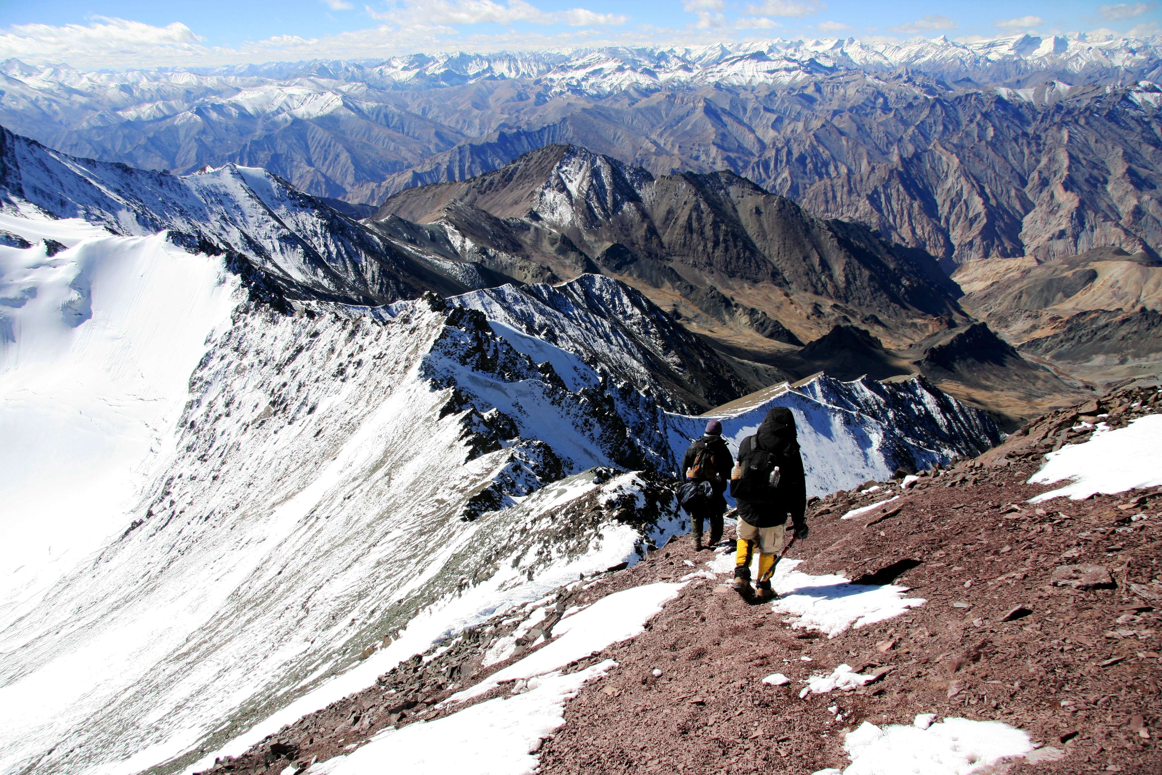
The Stok Kangri trek is a high-altitude mountaineering route in Ladakh, India, reaching a summit of 6,153 metres — one of India's most accessible 6,000m+ peaks.
Common questions answered
The trail officially opens on June 1 and closes on October 31 each year. The best bloom period is mid-July to mid-September. In years with heavy winter snowfall, the upper section of the trail near the valley entry may have residual snow patches until mid-June — check GMVN advisories if trekking in the first two weeks of June.
Live Conditions
Real-time weather & trail status
Trail Conditions
Crowdsourced reports from trekkers who've done this route
Sign in to add a trip report
Find a Trek Buddy
Connect with trekkers planning the same route
No buddies yet for this trek
Sign in and be the first to post a planning signal.